Zimbabwe Google maps and Driving Directions
Get free driving directions, Google maps, traffic information for Zimbabwe, and Harare (GPS: 17 49 S 31 02 E), the capital city of the country located in (the) Southern Africa, between South Africa and Zambia.
Find any address in Harare on the Google map of Zimbabwe (ZW) with ease or calculate your up to date itinerary to and from Zimbabwe or its neighboring counties like Botswana, Mozambique, South Africa, Zambia.
Sightseeing and exploring in Africa starts here, thanks to Google because its Earth Engine combines a multi-petabyte catalog of updated satellite imagery and geospatial datasets with planetary-scale analysis capabilities. Wonder the world, use the satellite map function of the Google maps to explore or see differences on the Earth’s surface, inland, or the surrounding areas of Zimbabwe.
Google Maps Zimbabwe
Situated in southern Africa, Zimbabwe achieved independence from the UK in 1980. President Robert Mugabe, in power since then, has become increasingly authoritarian.
Zimbabwe is mostly high plateau with higher central plateau (high veld); mountains in east.
The map above fully covers Zimbabwe with its road routes from cities to towns, road intersections in any region, provinces, prefectures, also with free driving directions in Harare or to the neighboring towns and countries. To look at the detailed map about a particular quarter in Harare, please click on the area and zoom to the place you are interested in the Google maps of Zimbabwe (ZW).
Be creative, use the extras of this Google map; This is a detailed, clear, zoomable, large road map of Zimbabwe with its administrative divisions; 8 provinces and 2 cities* with provincial status; Bulawayo*, Harare*, Manicaland, Mashonaland Central, Mashonaland East, Mashonaland West, Masvingo, Matabeleland North, Matabeleland South, Midlands.
The interactive map above is also may be used as the satellite map of Zimbabwe, or as a reverse search map for finding an address from its GPS coordinates.
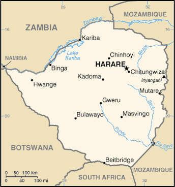
Zimbabwe, a landlocked country in south-central Africa, is slightly smaller than California. It is bordered by Botswana on the west, Zambia on the north, Mozambique on the east, and South Africa on the south.
Zimbabwe (area: 390 757 sq km / 150 872,06 sq mi), where the official language is Chewa, Chibarwe, Chitonga, English, Kalanga, Koisan, Nambya, Ndau, Shangani, Shona, Sign Language, Sotho, Southern Ndebele, Tswana, Venda, Xhosa, lying in Africa and using the currency; United States dollar (USD), set their clock to UTC+2. That means they are 7 hours ahead of Washington DC during Standard Time in Harare, the capital. Note to the time difference: N/A.
The climate in Zimbabwe; Tropical, though moderated by the high altitude. The wet season NovemberMarch. Drought is common in the eastern highlands.
Geography in a nutshell; High plateaus in center bordered by Zambezi River in the north and Limpopo in the south. Rivers crisscross central area.
Click here for more detailed information about Zimbabwe.
Driving directions Zimbabwe
The Google maps and Google Satellite maps of Zimbabwe above showing the country, located next to Botswana, Mozambique, South Africa, Zambia. For your further reference, the latitude and longitude coordinates of Zimbabwe are 20 00 S, 30 00 E , while the capital, Harare found at 17 49 S 31 02 E.
When you are traveling around Zimbabwe, Harare, or its other cities, use this routing tool, providing up to date route planning service free of charge.
Look no further; get accurate driving directions in Zimbabwe, Africa, by filling the route planner form below.
[xyz-ihs snippet=”routing”]
Since Google acquired and introduced its digitalized maps in 2004, you’re probably familiar with its base functions, like finding an address or driving directions to locations. Still, Google maps also accommodate bicyclists, pedestrians, and also public transportation with special directions and customizable routes.
About Zimbabwe and the capital, Harare
 |
 |
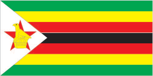
| The national flag of Zimbabwe | Borderline map of Zimbabwe |
| Flag description: seven equal horizontal bands of green, yellow, red, black, red, yellow, and green with a white isosceles triangle edged in black with its base on the hoist side; a yellow Zimbabwe bird representing the long history of the country is superimposed on a red five-pointed star in the center of the triangle, which symbolizes peace; green represents agriculture, yellow mineral wealth, red the bloodshed to achieve independence, and black stands for the native people. | Border length: total: 3,229 km. Border countries (total: 4): Botswana 834 km, Mozambique 1,402 km, South Africa 230 km, Zambia 763 km. |
Did you know about Zimbabwe?
- Zimbabwe, the name of an ancient African city, now applied to the whole country, which was formerly known as Rhodesia.
- The ruins of the 1000-year-old city of Great Zimbabwe, after which the country named, are near modern-day Masvingo.
- In the Bantu language, Zimbabwe means “stone houses and gets its name from the stone buildings of Great Zimbabwe-an ancient trading city.
Facts of Zimbabwe (ZW)
Name conventional long form: Republic of Zimbabwe, conventional short form: Zimbabwe, former: Southern Rhodesia, Rhodesia, etymology: takes its name from the Kingdom of Zimbabwe (13th-15th century) and its capital of Great Zimbabwe, the largest stone structure in pre-colonial southern Africa
Codes: ISO; ZW, Internet; .zw
Capital city: Harare
Language(s): Shona (official language; most widely spoken), Ndebele (official language, second most widely spoken), English (official language; traditionally used for official language business), 13 minority languages (official language; includes Chewa, Chibarwe, Kalanga, Koisan, Nambya, Ndau, Shangani, sign language, Sotho, Tonga, Tswana, Venda, and Xhosa)
National holiday(s): Independence Day, 18 April (1980)
Motto: Unity, Freedom, Work
Currency: United States dollar (USD)
GPS: 20 00 S, 30 00 E, Harare; 17 49 S 31 02 E
Location: Southern Africa, between South Africa and Zambia
Geography note: landlocked country; the Zambezi forms a natural riverine boundary with Zambia; in full flood (February-April) the massive Victoria Falls on the river forms the world’s largest curtain of falling water; Lake Kariba on the Zambia-Zimbabwe border forms the world’s largest reservoir by volume (180 cu km; 43 cu mi)
Land boundaries: Botswana 834 km, Mozambique 1,402 km, South Africa 230 km, Zambia 763 km, total: 3,229 km
Maritime boundaries: N/A
Coastline: 0 km (landlocked country)
Area: total: 390,757 sq km; land: 386,847 sq km, water: 3,910 sq km (total 150 872,06 mi2), slightly larger than Montana.
Roadways: total: 97,267 km, paved: 18,481 km, unpaved: 78,786 km (2002)
Waterways: (some navigation possible on Lake Kariba) (2011)
Local time (capital): UTC+2, 7 hours ahead of Washington DC during Standard Time
Note to the local time: N/A
Population in Zimbabwe: 16 913 261
Population in Harare: 1 542 000 (including the metropolitan areas)
Urbanization: urban population: 32.4% of total population (2015)
Major urban areas population: HARARE (capital) 1.501 million (2015)
Population growth rate: 2.2% (2016 estimate)
Birth rate: 31.9 births / 1,000 population (2016 estimate)
Death rate: 9.9 deaths / 1,000 population (2016 estimate)
Age structure: 0-14 years: 37.8% (male 2,778,806 / female 2,720,033) 15-24 years: 21.29% (male 1,560,833 / female 1,536,110) 25-54 years: 33.86% (male 2,578,142 / female 2,346,993) 55-64 years: 3.55% (male 188,851 / female 327,483) 65 years and over: 3.5% (male 194,933 / female 314,777) (2016 estimate)
Median age: total: 20.6 years; male: 20.5 years, female: 20.8 years (2016 estimate)
Ethnic groups: African 99.4% (predominantly Shona; Ndebele is the second largest ethnic group), other 0.4%, unspecified 0.2% (2012 estimate)
Religions: Protestant 75.9% (includes Apostolic 38%, Pentecostal 21.1%, other 16.8%), Roman Catholic 8.4%, other Christian 8.4%, other 1.2% (includes traditional, Muslim), none 6.1% (2011 estimate)
Government type: Unitary Dominant-party presidential republic
Legal system: mixed legal system of English common law, Roman-Dutch civil law, and customary law
National anthem: Kalibusiswe Ilizwe leZimbabwe (Blessed be the land of Zimbabwe)
Known national hazards: recurring droughts; floods and severe storms are rare
Major infectious diseases: The degree of risk(s): high food or waterborne diseases: bacterial and protozoal diarrhea, hepatitis A, and typhoid fever vectorborne diseases: malaria and dengue feverwater contact disease: schistosomiasis animal contact disease: rabies (2016)
Land use: agricultural land: 42.5%; arable land 10.9%; permanent crops 0.3%; permanent pasture 31.3%; forest: 39.5%; other: 18% (2011 estimate)
Agricultural products: tobacco, corn, cotton, wheat, coffee, sugarcane, peanuts; sheep, goats, pigs
Industries: mining (coal, gold, platinum, copper, nickel, tin, diamonds, clay, numerous metallic and nonmetallic ores), steel; wood products, cement, chemicals, fertilizer, clothing and footwear, foodstuffs, beverages
Export commodities: platinum, cotton, tobacco, gold, ferroalloys, textiles/clothing
Main export partners: China 27.8%, Democratic Republic of the Congo 14%, Botswana 12.5%, South Africa 7.6% (2015)
Import commodities: machinery and transport equipment, other manufactures, chemicals, fuels, food products
Main import partners: South Africa 48.1%, China 12.1%, India 5.2%, Zambia 4.6% (2015)
Navigate the countries in Africa faster and easier while driving, use the interactive Google maps for your driving directions. The continuously updated database contains over 220 countries and territories digitally mapped, hundreds of millions of businesses and places around the world positioned on the map.
Get fresh GPS navigation, traffic, and transit information – no matter what part of Zimbabwe, Harare, any other city and country in Africa, or the world you’re in.
Do you like this Zimbabwe information page? Please don’t forget to share it with others! Thank you.
17 thoughts on “Zimbabwe”
Comments are closed.