Serbia Google maps and Driving Directions
Get free driving directions, Google maps, traffic information for Serbia, and Belgrade (GPS: 44 50 N 20 30 E), the capital city of the country located in (the) Southeastern Europe, between Macedonia and Hungary.
Find any address in Belgrade on the Google map of Serbia (RS) with ease or calculate your up to date itinerary to and from Serbia or its neighboring counties like Bosnia and Herzegovina, Bulgaria, Croatia, Hungary, Kosovo, Macedonia, Montenegro, Romania.
Sightseeing and exploring in Europe starts here, thanks to Google because its Earth Engine combines a multi-petabyte catalog of updated satellite imagery and geospatial datasets with planetary-scale analysis capabilities. Wonder the world, use the satellite map function of the Google maps to explore or see differences on the Earth’s surface, inland, or the surrounding areas of Serbia.
Google Maps Serbia
The central and eastern region of what was once Yugoslavia, Serbia was a pariah state until Slobodan Milosevic was ousted in 2000. Montenegro broke away in 2006, and Kosovo in 2008.
Serbia is extremely varied; to the north, rich fertile plains; to the east, limestone ranges and basins; to the southeast, ancient mountains and hills.
The map above fully covers Serbia with its road routes from cities to towns, road intersections in any region, provinces, prefectures, also with free driving directions in Belgrade or to the neighboring towns and countries. To look at the detailed map about a particular quarter in Belgrade, please click on the area and zoom to the place you are interested in the Google maps of Serbia (RS).
Be creative, use the extras of this Google map; This is a detailed, clear, zoomable, large road map of Serbia with its administrative divisions; 119 municipalities (opstine, singular – opstina) and 26 cities (gradovi, singular – grad)municipalities: Ada*, Aleksandrovac, Aleksinac, Alibunar*, Apatin*, Arandelovac, Arilje, Babusnica, Bac*, Backa Palanka*, Backa Topola*, Backi Petrovac*, Bajina Basta, Batocina, Becej*, Bela Crkva*, Bela Palanka, Beocin*, Blace, Bogatic, Bojnik, Boljevac, Bor, Bosilegrad, Brus, Bujanovac, Cajetina, Cicevac, Coka*, Crna Trava, Cuprija, Despotovac, Dimitrov, Doljevac, Gadzin Han, Golubac, Gornji Milanovac, Indija*, Irig*, Ivanjica, Kanjiza*, Kladovo, Knic, Knjazevac, Koceljeva, Kosjeric, Kovacica*, Kovin*, Krupanj, Kucevo, Kula*, Kursumlija, Lajkovac, Lapovo, Lebane, Ljig, Ljubovija, Lucani, Majdanpek, Mali Idos*, Mali Zvornik, Malo Crnice, Medveda, Merosina, Mionica, Negotin, Nova Crnja*, Nova Varos, Novi Becej*, Novi Knezevac*, Odzaci*, Opovo*, Osecina, Paracin, Pecinci*, Petrovac na Mlavi, Plandiste*, Pozega, Presevo, Priboj, Prijepolje, Prokuplje, Raca, Raska, Razanj, Rekovac, Ruma*, Secanj*, Senta*, Sid*, Sjenica, Smederevska Palanka, Sokobanja, Srbobran*, Sremski Karlovci*, Stara Pazova*, Surdulica, Svilajnac, Svrljig, Temerin*, Titel*, Topola, Trgoviste, Trstenik, Tutin, Ub, Varvarin, Velika Plana, Veliko Gradiste, Vladicin Han, Vladimirci, Vlasotince, Vrbas*, Vrnjacka Banja, Zabalj*, Zabari, Zagubica, Zitiste*, Zitoradacities: Beograd, Cacak, Jagodina, Kikinda*, Kragujevac, Kraljevo, Krusevac, Leskovac, Loznica, Nis, Novi Pazar, Novi Sad*, Pancevo*, Pirot, Pozarevac, Sabac, Smederevo, Sombor*, Sremska Mitrovica*, Subotica*, Uzice, Valjevo, Vranje, Vrsac, Zajecar, Zrenjanin*note: the northern 39 municipalities and 6 cities – about 28% of Serbia’s area – compose the autonomous province of Vojvodina and are indicated with *.
The interactive map above is also may be used as the satellite map of Serbia, or as a reverse search map for finding an address from its GPS coordinates.
Serbia is largely mountainous. Its northeast section is part of the rich, fertile Danubian Plain drained by the Danube, Tisa, Sava, and Morava river systems. It borders Croatia on the northwest, Hungary on the north, Romania on the northeast, Bulgaria on the east, Macedonia on the south, and Albania, Montenegro, and Bosnia and Herzegovina on the west.
Serbia (area: 88 361 sq km / 34 116,36 sq mi), where the official language is Serbian, lying in Europe and using the currency; Serbian dinar (RSD), since 1214, set their clock to UTC+1. That means they are 6 hours ahead of Washington DC during Standard Time in Belgrade, the capital. Note to the time difference: Daylight saving time: +1hr begins last Sunday in March; ends last Sunday in October.
The climate in Serbia; Continental in north, with wet springs and warm summers. Colder winters with heavy snow in south.
Geography in a nutshell; Landlocked since secession of Montenegro. Fertile Danube plain in the north, rolling uplands in the center and southeast. Mountains in southwest.
Click here for more detailed information about Serbia.
Driving directions Serbia
The Google maps and Google Satellite maps of Serbia above showing the country, located next to Bosnia and Herzegovina, Bulgaria, Croatia, Hungary, Kosovo, Macedonia, Montenegro, Romania. For your further reference, the latitude and longitude coordinates of Serbia are 44 00 N, 21 00 E , while the capital, Belgrade found at 44 50 N 20 30 E.
When you are traveling around Serbia, Belgrade, or its other cities, use this routing tool, providing up to date route planning service free of charge.
Look no further; get accurate driving directions in Serbia, Europe, by filling the route planner form below.
Since Google acquired and introduced its digitalized maps in 2004, you’re probably familiar with its base functions, like finding an address or driving directions to locations. Still, Google maps also accommodate bicyclists, pedestrians, and also public transportation with special directions and customizable routes.
About Serbia and the capital, Belgrade
 |
 |
| The national flag of Serbia | Borderline map of Serbia |
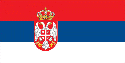
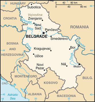
| Flag description: three equal horizontal stripes of red (top), blue, and white – the Pan-Slav colors representing freedom and revolutionary ideals; charged with the coat of arms of Serbia shifted slightly to the hoist side; the principal field of the coat of arms represents the Serbian state and displays a white two-headed eagle on a red shield; a smaller red shield on the eagle represents the Serbian nation, and is divided into four quarters by a white cross; interpretations vary as to the meaning and origin of the white, curved symbols resembling firesteels or Cyrillic “C’s” in each quarter; a royal crown surmounts the coat of arms. Note: the Pan-Slav colors were inspired by the 19th-century flag of Russia. | Border length: total: 2,322 km. Border countries (total: 8): Bosnia and Herzegovina 345 km, Bulgaria 344 km, Croatia 314 km, Hungary 164 km, Kosovo 366 km, Macedonia 101 km, Montenegro 157 km, Romania 531 km. |
About Belgrade
Belgrade (Београд; Beograd) is a lively, high-energy city, especially in spring and summer, when all ages throng the streets at all hours. With a seemingly endless supply of bars and clubs, the city’s pulsing nightlife is one of the unexpected high points on any European itinerary. The town sits at a strategic position on the junction of the Danube and Sava rivers, something that has proved a source of weakness as well as strength over the ages: Belgrade has been captured as many as sixty times by Celts, Romans, Huns, Avars and more.
The onslaught continued right through the twentieth century when the city suffered heavy shelling during World War II and in 1999 withstood 78 days of NATO airstrikes. Visually, the mingling and merging of architectural styles can be off-putting, particularly when a row of beautiful older frontages is interrupted by a postwar interloper. Yet this mishmash also makes the city what it is: alongside all the Yugoslav experimentation, the grand nineteenth-century buildings and Art Nouveau facades bear eloquent witness to the days of Ottoman and Austro- Hungarian rule.
Did you know about Serbia?
- Serbia was a kingdom, until conquered by theTurks. It regained independence in the 19th century, Yugoslavia united in 1919, but separated 1991-2006.
- The medieval Serbian Empire reached into northern Greece.
- The Serbs are Orthodox Christians and share a language with the Croats, although they use different scripts to write it down.
Serbia is a buzzy and boisterous country, compact enough for visitors to sample both Belgrade’s urban hedonism and the gentler pace of the smaller towns or national parks within a few days – and it’s one of Europe’s most affordable destinations to boot. Grittier than its blue-eyed neighbor Croatia, it is nevertheless an integral part of any backpacker’s Balkan tour. At the heart of the region, it gives easy access to the cluster of cultures and histories crammed into this small corner of Europe.
Facts of Serbia (RS)
Name conventional long form: Republic of Serbia, conventional short form: Serbia, local long form: Republika Srbija, local short form: Srbija, former: People’s Republic of Serbia, Socialist Republic of Serbia, etymology: the origin of the name in uncertain, but seems to be related to the name of the West Slavic Sorbs who reside in the Lusatian region in present-day eastern Germany; by tradition, the Serbs migrated from that region to the Balkans in about the 6th century A.D.
Codes: ISO; RS, Internet; .rs
Capital city: Belgrade
Language(s): Serbian (official language) 88.1%, Hungarian 3.4%, Bosnian 1.9%, Romany 1.4%, other 3.4%, undeclared or unknown 1.8%. Note: Serbian, Hungarian, Slovak, Romanian, Croatian, and Rusyn are official language in Vojvodina (2011 estimate)
National holiday(s): National Day, 15 February (1835), the day the first constitution of the country was adopted
Motto: N/A
Currency: Serbian dinar (RSD), since 1214
GPS: 44 00 N, 21 00 E, Belgrade; 44 50 N 20 30 E
Location: Southeastern Europe, between Macedonia and Hungary
Geography note: controls one of the major land routes from Western Europe to Turkey and the Near East
Land boundaries: Bosnia and Herzegovina 345 km, Bulgaria 344 km, Croatia 314 km, Hungary 164 km, Kosovo 366 km, Macedonia 101 km, Montenegro 157 km, Romania 531 km, total: 2,322 km
Maritime boundaries: N/A
Coastline: 0 km (landlocked country)
Area: total: 77,474 sq km; land: 77,474 sq km, water: 0 sq km (total 34 116,36 mi2), slightly smaller than South Carolina.
Roadways: total: 44,248 km, paved: 28,000 km, unpaved: 16,248 km (2010)
Waterways: 587 km (primarily on the Danube and Sava rivers) (2009)
Local time (capital): UTC+1, 6 hours ahead of Washington DC during Standard Time
Note to the local time: Daylight saving time: +1hr begins last Sunday in March; ends last Sunday in October
Population in Serbia: 8 762 027
Population in Belgrade: 1 135 000 (including the metropolitan areas)
Urbanization: urban population: 55.6% of total population (2015)
Major urban areas population: BELGRADE (capital) 1.182 million (2015)
Population growth rate: -0.46% (2016 estimate)
Birth rate: 9 births / 1,000 population (2016 estimate)
Death rate: 13.6 deaths / 1,000 population (2016 estimate)
Age structure: 0-14 years: 14.64% (male 539,189 / female 506,727) 15-24 years: 11.34% (male 417,692 / female 392,379) 25-54 years: 41.41% (male 1,492,799 / female 1,465,270) 55-64 years: 14.58% (male 502,172 / female 539,349) 65 years and over: 18.03% (male 530,827 / female 757,517) (2016 estimate)
Median age: total: 42.3 years; male: 40.7 years, female: 44 years (2016 estimate)
Ethnic groups: Serb 83.3%, Hungarian 3.5%, Romany 2.1%, Bosniak 2%, other 5.7%, undeclared or unknown 3.4% (2011 estimate)
Religions: Serbian Orthodox 84.6%, Catholic 5%, Muslim 3.1%, Protestant 1%, atheist 1.1%, other 0.8%, undeclared or unknown 4.5% (2011 estimate)
Government type: Unitary parliamentary constitutional republic
Legal system: civil law system
National anthem: Boze Pravde (God of Justice)
Known national hazards: destructive earthquakes
Major infectious diseases: The degree of risk(s): intermediatefood or waterborne diseases: bacterial diarrhea (2016)
Land use: agricultural land: 57.9%; arable land 37.7%; permanent crops 3.4%; permanent pasture 16.8%; forest: 31.6%; other: 10.5% (2011 estimate)
Agricultural products: wheat, maize, sunflower, sugar beets, grapes/wine, fruits (raspberries, apples, sour cherries), vegetables (tomatoes, peppers, potatoes), beef, pork, and meat products, milk and dairy products
Industries: automobiles, base metals, furniture, food processing, machinery, chemicals, sugar, tires, clothes, pharmaceuticals
Export commodities: iron and steel, rubber, clothes, wheat, fruit and vegetables, nonferrous metals, electric appliances, metal products, weapons and ammunition, automobiles
Main export partners: Italy 16.2%, Germany 12.6%, Bosnia and Herzegovina 8.7%, Romania 5.6%, Russia 5.4% (2015)
Import commodities: machinery and transport equipment, fuels and lubricants, manufactured goods, chemicals, food and live animals, raw materials
Main import partners: Germany 12.4%, Italy 10.6%, Russia 9.6%, China 8.5%, Hungary 4.8%, Poland 4.2% (2015)
Navigate the countries in Europe faster and easier while driving, use the interactive Google maps for your driving directions. The continuously updated database contains over 220 countries and territories digitally mapped, hundreds of millions of businesses and places around the world positioned on the map.
Get fresh GPS navigation, traffic, and transit information – no matter what part of Serbia, Belgrade, any other city and country in Europe, or the world you’re in.
Do you like this Serbia information page? Please don’t forget to share it with others! Thank you.