Hungary Google maps and Driving Directions
Get free driving directions, Google maps, traffic information for Hungary, and Budapest (GPS: 47 30 N 19 05 E), the capital city of the country located in (the) Central Europe, northwest of Romania.
Find any address in Budapest on the Google map of Hungary (HU) with ease or calculate your up to date itinerary to and from Hungary or its neighboring counties like Austria, Croatia, Romania, Serbia, Slovakia, Slovenia, Ukraine.
Sightseeing and exploring in Europe starts here, thanks to Google because its Earth Engine combines a multi-petabyte catalog of updated satellite imagery and geospatial datasets with planetary-scale analysis capabilities. Wonder the world, use the satellite map function of the Google maps to explore or see differences on the Earth’s surface, inland, or the surrounding areas of Hungary.
Google Maps Hungary
Landlocked in central Europe, Hungary was one of the twin centers of the once-great Habsburg Empire. It lost two-thirds of its historical territory for supporting Germany in World War I.
Hungary is mostly flat to rolling plains; hills and low mountains on the Slovakian border.
The map above fully covers Hungary with its road routes from cities to towns, road intersections in any region, provinces, prefectures, also with free driving directions in Budapest or to the neighboring towns and countries. To look at the detailed map about a particular quarter in Budapest, please click on the area and zoom to the place you are interested in the Google maps of Hungary (HU).
Be creative, use the extras of this Google map; This is a detailed, clear, zoomable, large road map of Hungary with its administrative divisions; 19 counties (megyek, singular – megye), 23 cities with county rights (megyei jogu varosok, singular – megyei jogu varos), and 1 capital city (fovaros)counties: Bacs-Kiskun, Baranya, Bekes, Borsod-Abauj-Zemplen, Csongrad, Fejer, Gyor-Moson-Sopron, Hajdu-Bihar, Heves, Jasz-Nagykun-Szolnok, Komarom-Esztergom, Nograd, Pest, Somogy, Szabolcs-Szatmar-Bereg, Tolna, Vas, Veszprem, Zalacities with county rights: Bekescsaba, Debrecen, Dunaujvaros, Eger, Erd, Gyor, Hodmezovasarhely, Kaposvar, Kecskemet, Miskolc, Nagykanizsa, Nyiregyhaza, Pecs, Salgotarjan, Sopron, Szeged, Szekesfehervar, Szekszard, Szolnok, Szombathely, Tatabanya, Veszprem, Zalaegerszegcapital city: Budapest.
The interactive map above is also may be used as the satellite map of Hungary, or as a reverse search map for finding an address from its GPS coordinates.
This central European country is the size of Indiana. Most of Hungary is a fertile, rolling plain lying east of the Danube River and drained by the Danube and Tisza rivers. In the extreme northwest is the Little Hungarian Plain. South of that area is Lake Balaton (250 sq mi 648 sq km). Hungary shares borders with seven neighboring countries. In order of shared border length, these are: Slovakia (627 km), Romania (424 km), Croatia (348 km), Austria (321 km), Serbia (164 km), Ukraine (128 km), and Slovenia (94 km).
Hungary (area: 93 028 sq km / 35 918,30 sq mi), where the official language is Hungarian, lying in Europe and using the currency; Hungarian forint (HUF), since 1946, set their clock to UTC+1. That means they are 6 hours ahead of Washington DC during Standard Time in Budapest, the capital. Note to the time difference: Daylight saving time: +1hr begins last Sunday in March; ends last Sunday in October.
The climate in Hungary; Continental, with wet springs, late but very hot summers, and cold, cloudy winters. The transition between seasons tends to be sudden.
Geography in a nutshell; Landlocked. Fertile plains in east and north west; west and north are hilly. The Danube River cuts through the country and the capital.
Click here for more detailed information about Hungary.
Driving directions Hungary
The Google maps and Google Satellite maps of Hungary above showing the country, located next to Austria, Croatia, Romania, Serbia, Slovakia, Slovenia, Ukraine. For your further reference, the latitude and longitude coordinates of Hungary are 47 00 N, 20 00 E , while the capital, Budapest found at 47 30 N 19 05 E.
When you are traveling around Hungary, Budapest, or its other cities, use this routing tool, providing up to date route planning service free of charge.
Look no further; get accurate driving directions in Hungary, Europe, by filling the route planner form below.
Since Google acquired and introduced its digitalized maps in 2004, you’re probably familiar with its base functions, like finding an address or driving directions to locations. Still, Google maps also accommodate bicyclists, pedestrians, and also public transportation with special directions and customizable routes.
About Hungary and the capital, Budapest
 |
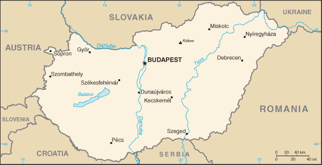 |
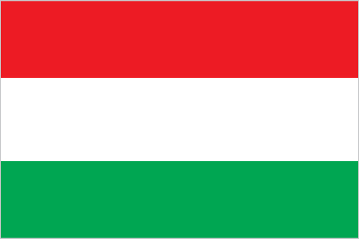
| The national flag of Hungary | Borderline map of Hungary |
| Flag description: three equal horizontal bands of red (top), white, and green; the flag dates to the national movement of the 18th and 19th centuries, and fuses the medieval colors of the Hungarian coat of arms with the revolutionary tricolor form of the French flag; folklore attributes virtues to the colors: red for strength, white for faithfulness, and green for hope; alternatively, the red is seen as being for the blood spilled in defense of the land, white for freedom, and green for the pasturelands that make up so much of the country. | Border length: total: 2,106 km. Border countries (total: 7): Austria 321 km, Croatia 348 km, Romania 424 km, Serbia 164 km, Slovakia 627 km, Slovenia 94 km, Ukraine 128 km. |
About Budapest
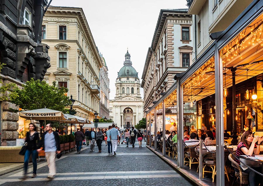
Budapest has a glorious history, having once rivaled its neighboring Vienna under the Austro-Hungarian monarchy. But don’t let the city’s rich past fool you: The Budapest of today buzzes with a culture that is becoming more and more dynamically European. A vibrant young generation is proof of this. While the political elite continues to argue about the past, the youth are concentrating on the future. They’re becoming multilingual; they’re creating new film festivals and fashion shows. The scene they’re developing is vibrant and fun – if a bit secretive and cliquish. While it might take some time to enter into their world, it’s a pleasurable journey in the end. They are playing catchup, living off the seat of their pants.
Did you know about Hungary?
- Part of Austria-Hungary until 1918, Hungary became part of the communist bloc from 1945-1989.
- The Hungarian language is Asian in origin and is most closely related to Finnish.
- Budapest, the capital of Hungary, was once two cities, with Buda and its magnificent castle on one side of the River Danube and Pest on the other.
Hungary is a landlocked country sharing borders with Austria, Slovenia, Croatia, Yugoslavia, Romania, and Ukraine. It is a region of plains ringed by the high mountain ranges of neighboring countries. The main topographical feature is the Great Plain or Great Alföld.
The Danube and its tributaries, being navigable, form an important part of the country’s transportation system and are the source of most of the country’s water for domestic and industrial needs. About 18 percent of the country covered with forest.
Hungary has traditionally been an agricultural country and around half the land area is suitable for agriculture, although irrigation is necessary to ensure productivity. Hungary is relatively poor in mineral resources and heavily reliant upon imports of oil and coal to supply its energy needs although over 40 percent of electricity generated by nuclear power. The economy has a sizeable industrial base and tourism also makes a significant contribution to the economy. Hungary’s capital, the beautiful ancient city of Budapest, and Lake Balaton are two of Hungary’s most popular tourist destinations.
Facts of Hungary (HU)
Name conventional long form: none, conventional short form: Hungary, local long form: none, local short form: Magyarorszag, etymology: the Byzantine Greeks refered to the tribes that arrived on the steppes of Eastern Europe in the 9th century as the “Oungroi,” a name that was later Latinized to “Ungri” and which became “Hungari”; the name originally meant an “[alliance of] ten tribes”; the Hungarian name “Magyarorszag” means “Land of the Magyars”; the term may derive from the most prominent of the Hungarian tribes, the Megyer
Codes: ISO; HU, Internet; .hu
Capital city: Budapest
Language(s): Hungarian (official language) 99.6%, English 16%, German 11.2%, Russian 1.6%, Romanian 1.3%, French 1.2%, other 4.2%. Note: shares sum to more than 100% because some respondents gave more than one answer on the census; Hungarian is the mother tongue of 98.9% of Hungarian speakers (2011 estimate)
National holiday(s): Saint Stephen’s Day, 20 August
Motto: N/A
Currency: Hungarian forint (HUF), since 1946
GPS: 47 00 N, 20 00 E, Budapest; 47 30 N 19 05 E
Location: Central Europe, northwest of Romania
Geography note: landlocked country; strategic location astride main land routes between Western Europe and Balkan Peninsula as well as between Ukraine and Mediterranean basin; the north-south flowing Duna (Danube) and Tisza Rivers divide the country into three large regions
Land boundaries: Austria 321 km, Croatia 348 km, Romania 424 km, Serbia 164 km, Slovakia 627 km, Slovenia 94 km, Ukraine 128 km, total: 2,106 km
Maritime boundaries: N/A
Coastline: 0 km (landlocked country)
Area: total: 93,028 sq km; land: 89,608 sq km, water: 3,420 sq km (total 35 918,30 mi2), slightly smaller than Virginia; about the same size as Indiana.
Roadways: total: 203,601 km, paved: 77,087 km (includes 1,582 km of expressways), unpaved: 126,514 km (2014)
Waterways: 1,622 km (most on Danube River) (2011)
Local time (capital): UTC+1, 6 hours ahead of Washington DC during Standard Time
Note to the local time: Daylight saving time: +1hr begins last Sunday in March; ends last Sunday in October
Population in Hungary: 9 688 847
Population in Budapest: 2 597 000 (including the metropolitan areas)
Urbanization: urban population: 71.2% of total population (2015)
Major urban areas population: BUDAPEST (capital) 1.714 million (2015)
Population growth rate: -0.24% (2016 estimate)
Birth rate: 9.1 births / 1,000 population (2016 estimate)
Death rate: 12.8 deaths / 1,000 population (2016 estimate)
Age structure: 0-14 years: 14.76% (male 750,516 / female 706,780) 15-24 years: 11.19% (male 570,097 / female 534,856) 25-54 years: 41.74% (male 2,071,865 / female 2,049,939) 55-64 years: 13.66% (male 620,362 / female 728,387) 65 years and over: 18.65% (male 693,609 / female 1,148,373) (2016 estimate)
Median age: total: 41.8 years; male: 39.9 years, female: 44.1 years (2016 estimate)
Ethnic groups: Hungarian 85.6%, Roma 3.2%, German 1.9%, other 2.6%, unspecified 14.1%note: percentages add up to more than 100% because respondents were able to identify more than one ethnic group (2011 estimate)
Religions: Roman Catholic 37.2%, Calvinist 11.6%, Lutheran 2.2%, Greek Catholic 1.8%, other 1.9%, none 18.2%, unspecified 27.2% (2011 estimate)
Government type: Unitary parliamentary constitutional republic
Legal system: civil legal system influenced by the German model
National anthem: Himnusz
Known national hazards: N/A
Major infectious diseases: The degree of risk(s): intermediatevectorborne diseases: tickborne encephalitis (2016)
Land use: agricultural land: 58.9%; arable land 48.5%; permanent crops 2%; permanent pasture 8.4%; forest: 22.5%; other: 18.6% (2011 estimate)
Agricultural products: wheat, corn, sunflower seed, potatoes, sugar beets; pigs, cattle, poultry, dairy products
Industries: mining, metallurgy, construction materials, processed foods, textiles, chemicals (especially pharmaceuticals), motor vehicles
Export commodities: machinery and equipment 53.5%, other manufactures 31.2%, food products 8.7%, raw materials 3.4%, fuels and electricity 3.9% (2012 estimate)
Main export partners: Germany 28%, Romania 5.4%, Slovakia 5.1%, Austria 5%, Italy 4.8%, France 4.7%, UK 4%, Czech Republic 4% (2015)
Import commodities: machinery and equipment 45.4%, other manufactures 34.3%, fuels and electricity 12.6%, food products 5.3%, raw materials 2.5% (2012)
Main import partners: Germany 25.8%, China 6.7%, Austria 6.6%, Poland 5.5%, Slovakia 5.3%, France 5%, Czech Republic 4.8%, Netherlands 4.6%, Italy 4.5% (2015)
Navigate the countries in Europe faster and easier while driving, use the interactive Google maps for your driving directions. The continuously updated database contains over 220 countries and territories digitally mapped, hundreds of millions of businesses and places around the world positioned on the map.
Get fresh GPS navigation, traffic, and transit information – no matter what part of Hungary, Budapest, any other city and country in Europe, or the world you’re in.
Do you like this Hungary information page? Please don’t forget to share it with others! Thank you.