Albania Google maps and Driving Directions
Get free driving directions, Google maps, traffic information for Albania, and Tirana (GPS: 41 19 N 19 49 E), the capital city of the country located in (the) Southeastern Europe, bordering the Adriatic Sea and Ionian Sea, between Greece to the south and Montenegro and Kosovo to the north.
Find any address in Tirana on the Google map of Albania (AL) with ease or calculate your up to date itinerary to and from Albania or its neighboring counties like Greece, Kosovo, Macedonia, Montenegro.
Sightseeing and exploring in Europe starts here, thanks to Google because its Earth Engine combines a multi-petabyte catalog of updated satellite imagery and geospatial datasets with planetary-scale analysis capabilities. Wonder the world, use the satellite map function of the Google maps to explore or see differences on the Earth’s surface, inland, or the surrounding areas of Albania.
Google Maps Albania
Lying at the southeastern end of the Adriatic Sea, Albania was the last east European country to liberalize its economy. The regional strife of the 1990s has left a difficult legacy.
Albania is mostly mountains and hills; small plains along coast.
The map above fully covers Albania with its road routes from cities to towns, road intersections in any region, provinces, prefectures, also with free driving directions in Tirana or to the neighboring towns and countries. To look at the detailed map about a particular quarter in Tirana, please click on the area and zoom to the place you are interested in the Google maps of Albania (AL).
Be creative, use the extras of this Google map; This is a detailed, clear, zoomable, large road map of Albania with its administrative divisions; 12 counties (qarqe, singular – qark); Berat, Diber, Durres, Elbasan, Fier, Gjirokaster, Korce, Kukes, Lezhe, Shkoder, Tirane, Vlore.
The interactive map above is also may be used as the satellite map of Albania, or as a reverse search map for finding an address from its GPS coordinates.
Albania is situated on the eastern shore of the Adriatic Sea, with Montenegro and Serbia to the north, Macedonia to the east, and Greece to the south. Slightly larger than Maryland, Albania is composed of two major regions: a mountainous highland region (north, east, and south) constituting 70% of the land area, and a western coastal lowland region that contains nearly all of the country’s agricultural land and is the most densely populated part of Albania.
Albania (area: 28 748 sq km / 11 099,66 sq mi), where the official language is Albanian, lying in Europe and using the currency; Albanian lek (ALL), since 1926, set their clock to UTC+1. That means they are 6 hours ahead of Washington DC during Standard Time in Tirana, the capital. Note to the time difference: Daylight saving time: +1hr begins last Sunday in March; ends last Sunday in October.
The climate in Albania; Mediterranean coastal climate, with warm summers and cool winters. Mountains receive heavy rains or snows in winter.
Geography in a nutshell; Narrow coastal plain. Interior is mostly hills and mountains. Forest and scrub cover over 40% of the land.
Click here for more detailed information about Albania.
Driving directions Albania
The Google maps and Google Satellite maps of Albania above showing the country, located next to Greece, Kosovo, Macedonia, Montenegro. For your further reference, the latitude and longitude coordinates of Albania are 41 00 N, 20 00 E , while the capital, Tirana found at 41 19 N 19 49 E.
When you are traveling around Albania, Tirana, or its other cities, use this routing tool, providing up to date route planning service free of charge.
Look no further; get accurate driving directions in Albania, Europe, by filling the route planner form below.
Since Google acquired and introduced its digitalized maps in 2004, you’re probably familiar with its base functions, like finding an address or driving directions to locations. Still, Google maps also accommodate bicyclists, pedestrians, and also public transportation with special directions and customizable routes.
About Albania and the capital, Tirana
 |
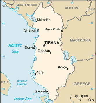 |
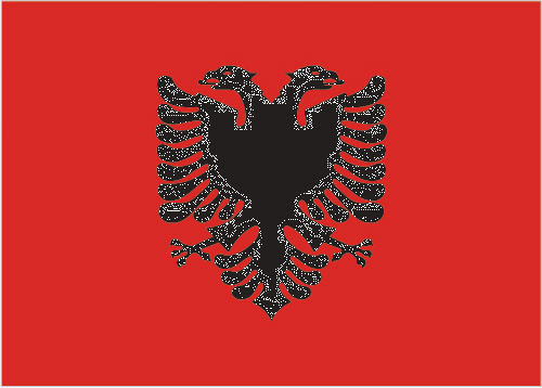
| The national flag of Albania | Borderline map of Albania |
| Flag description: red with a black two-headed eagle in the center; the design is claimed to be that of 15th-century hero George Kastrioti SKANDERBEG, who led a successful uprising against the Ottoman Turks that resulted in a short-lived independence for some Albanian regions (1443-78); an unsubstantiated explanation for the eagle symbol is the tradition that Albanians see themselves as descendants of the eagle; they refer to themselves as “Shqiptare,” which translates as “sons of the eagle”. | Border length: total: 691 km. Border countries (total: 4): Greece 212 km, Kosovo 112 km, Macedonia 181 km, Montenegro 186 km. |
About Tirana
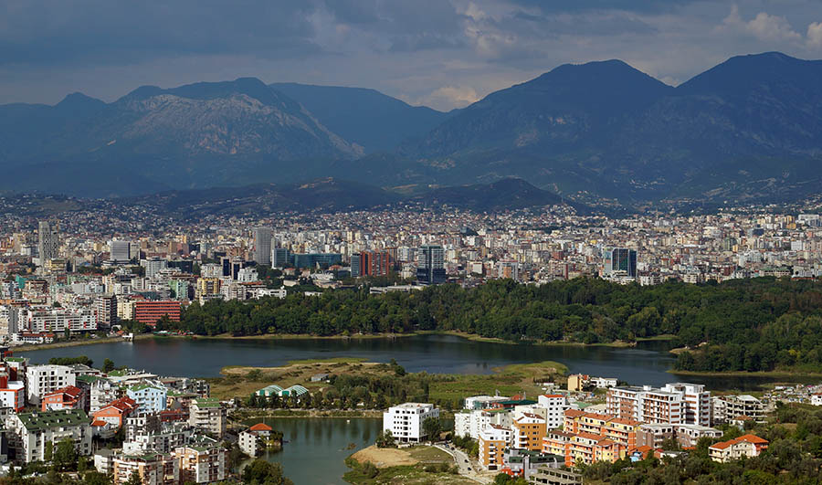
Its buildings painted in lurid colors, a gigantic, useless pyramid rises smack in the center, the main square is a mess, the roads are potholed, and still, there’s no official bus station for this city of almost one million people. Yet, for all these quirks, Tirana is undeniably a charmer. The clash of architectural styles (from Italian to Communist to postmodern) is most evident in the central Blloku area, which was off-limits to all but Party members during Communist times. A generation or so down the line, espresso sipping, funloving locals and trendy bar openings are vivid proof that the city is well on its way to becoming a “regular” European capital.
Tirana’s Ottoman legacy was primarily eroded by former dictator Enver Hoxha’s failed regime, an era still evidenced by enormous boulevards and Brutalist architecture. In 2000, the Edi Rama period began with the city’s charismatic mayor attempting to paint Tirana into the modern-day; the resulting streetscape kaleidoscope performs a continuous palette shift from lemon to lime, saffron to cinnamon and burgundy to baby blue. Some locals grumble that their city looks to have fallen victim to a made-for-TV makeover.
Did you know about Albania?
- Once part of the Byzantine Empire, Albania became a kingdom in 1912. From 1944 to 1991 it was a strict communist state.
- The Albanians name for their country, Shqipërisë, means “Land of the Eagles”.
- Albania is largely agricultural with most Albanians working on the land for a living.
Albania is a small, mountainous republic bounded by Montenegro (Yugoslavia) in the northwest, Serbia (Yugoslavia) in the north, Macedonia in the east and Greece in the southeast. The country’s western border formed by the Adriatic Sea, and behind the coast the land is low-lying and fertile although rather marshy in places. Away from the coast, the land rises to form a series of wild and rugged hills and mountains. In the north, these form the southernmost extension of the Dinaric Alps and are called the Albanian Alps.
Many large rivers, including the Drin and the Vijose, rise in the mountains and flow in a generally westerly direction towards the sea. There are also numerous beautiful freshwater lakes and extensive forests covering the hills and lower mountain slopes. Along the Adriatic coast, where a Mediterranean-type climate prevails, citrus fruit trees, olives, vines, palms, figs, laurel, and myrtle able to grow. The capital, Tirane, is situated in the center of the country.
Albania is one of the most impoverished and poorly developed countries in Europe, and this is largely because of factors in its recent political history. However, the country possesses valuable mineral resources, especially chromium, nickel, copper, iron ore, coal, petroleum and pyrites, and the mining and processing of these minerals is important to the Albanian economy. Some industries and manufacturing plants have developed, and agriculture, fishing, and forestry are also important to the country’s economy.
Facts of Albania (AL)
Name conventional long form: Republic of Albania, conventional short form: Albania, local long form: Republika e Shqiperise, local short form: Shqiperia, former: People’s Socialist Republic of Albania, etymology: the English-language country name seems to be derived from the ancient Illyrian tribe of the Albani; the native name “Shqiperia” is popularly interpreted to mean “Land of the eagles”
Codes: ISO; AL, Internet; .al
Capital city: Tirana
Language(s): Albanian 98.8% (official language – derived from Tosk dialect), Greek 0.5%, other 0.6% (including Macedonian, Roma, Vlach, Turkish, Italian, and Serbo-Croatian), unspecified 0.1% (2011 estimate)
National holiday(s): Independence Day, 28 November (1912) also known as Flag Day
Motto: Ti Shqipëri, më jep nder, më jep emrin Shqipëtar (You Albania, give me honour, give me the name Albanian)
Currency: Albanian lek (ALL), since 1926
GPS: 41 00 N, 20 00 E, Tirana; 41 19 N 19 49 E
Location: Southeastern Europe, bordering the Adriatic Sea and Ionian Sea, between Greece to the south and Montenegro and Kosovo to the north
Geography note: strategic location along Strait of Otranto (links Adriatic Sea to Ionian Sea and Mediterranean Sea)
Land boundaries: Greece 212 km, Kosovo 112 km, Macedonia 181 km, Montenegro 186 km, total: 691 km
Maritime boundaries: Adriatic Sea, Ionian Sea
Coastline: 362 km
Area: total: 28,748 sq km; land: 27,398 sq km, water: 1,350 sq km (total 11 099,66 mi2), slightly smaller than Maryland.
Roadways: total: 18,000 km, paved: 7,020 km, unpaved: 10,980 km (2002)
Waterways: 41 km (on the Bojana River) (2011)
Local time (capital): UTC+1, 6 hours ahead of Washington DC during Standard Time
Note to the local time: Daylight saving time: +1hr begins last Sunday in March; ends last Sunday in October
Population in Albania: 2 934 363
Population in Tirana: 353 400 (including the metropolitan areas)
Urbanization: urban population: 57.4% of total population (2015)
Major urban areas population: TIRANA (capital) 454,000 (2015)
Population growth rate: 0.31% (2016 estimate)
Birth rate: 13.1 births / 1,000 population (2016 estimate)
Death rate: 6.7 deaths / 1,000 population (2016 estimate)
Age structure: 0-14 years: 18.37% (male 295,022 / female 263,141) 15-24 years: 18.09% (male 284,201 / female 265,530) 25-54 years: 40.73% (male 589,707 / female 648,021) 55-64 years: 11.23% (male 168,500 / female 172,587) 65 years and over: 11.58% (male 165,076 / female 186,809) (2016 estimate)
Median age: total: 32.5 years; male: 31.2 years, female: 33.8 years (2016 estimate)
Ethnic groups: Albanian 82.6%, Greek 0.9%, other 1% (including Vlach, Roma (Gypsy), Macedonian, Montenegrin, and Egyptian), unspecified 15.5% (2011 estimate)
Religions: Muslim 56.7%, Roman Catholic 10%, Orthodox 6.8%, atheist 2.5%, Bektashi (a Sufi order) 2.1%, other 5.7%, unspecified 16.2%note: all mosques and churches were closed in 1967 and religious observances prohibited; in November 1990, Albania began allowing private religious practice (2011 estimate)
Government type: Unitary parliamentary constitutional republic
Legal system: civil law system except in the northern rural areas where customary law known as the “Code of Leke” prevails
National anthem: Albanian National Anthem
Known national hazards: destructive earthquakes; tsunamis occur along southwestern coast; floods; drought
Major infectious diseases: N/A
Land use: agricultural land: 43.8%; arable land 22.7%; permanent crops 2.7%; permanent pasture 18.4%; forest: 28.3%; other: 27.9% (2011 estimate)
Agricultural products: wheat, corn, potatoes, vegetables, fruits, sugar beets, grapes; meat, dairy products; sheep
Industries: food and tobacco products; textiles and clothing; lumber, oil, cement, chemicals, mining, basic metals, hydropower
Export commodities: textiles, footwear; asphalt, metals and metallic ores, crude oil; vegetables, fruits, tobacco
Main export partners: Italy 43.4%, Kosovo 9.8%, US 7.7%, China 6.2%, Greece 5.3%, Spain 4.8% (2015)
Import commodities: machinery and equipment, foodstuffs, textiles, chemicals
Main import partners: Italy 33.5%, China 10.1%, Greece 9%, Turkey 6.7%, Germany 5.2% (2015)
Navigate the countries in Europe faster and easier while driving, use the interactive Google maps for your driving directions. The continuously updated database contains over 220 countries and territories digitally mapped, hundreds of millions of businesses and places around the world positioned on the map.
Get fresh GPS navigation, traffic, and transit information – no matter what part of Albania, Tirana, any other city and country in Europe, or the world you’re in.
Do you like this Albania information page? Please don’t forget to share it with others! Thank you.