Montenegro Google maps and Driving Directions
Get free driving directions, Google maps, traffic information for Montenegro, and Podgorica (GPS: 42 26 N 19 16 E), the capital city of the country located in (the) Southeastern Europe, between the Adriatic Sea and Serbia.
Find any address in Podgorica on the Google map of Montenegro (ME) with ease or calculate your up to date itinerary to and from Montenegro or its neighboring counties like Albania, Bosnia and Herzegovina, Croatia, Kosovo, Serbia.
Sightseeing and exploring in Europe starts here, thanks to Google because its Earth Engine combines a multi-petabyte catalog of updated satellite imagery and geospatial datasets with planetary-scale analysis capabilities. Wonder the world, use the satellite map function of the Google maps to explore or see differences on the Earth’s surface, inland, or the surrounding areas of Montenegro.
Google Maps Montenegro
Perched on the Adriatic coast, this tiny republic became a separate state in 2006, after 88 years of federation with its neighbors in various forms of the state of Yugoslavia.
Montenegro is highly indented coastline with narrow coastal plain backed by rugged high limestone mountains and plateaus.
The map above fully covers Montenegro with its road routes from cities to towns, road intersections in any region, provinces, prefectures, also with free driving directions in Podgorica or to the neighboring towns and countries. To look at the detailed map about a particular quarter in Podgorica, please click on the area and zoom to the place you are interested in the Google maps of Montenegro (ME).
Be creative, use the extras of this Google map; This is a detailed, clear, zoomable, large road map of Montenegro with its administrative divisions; 23 municipalities (opstine, singular – opstina); Andrijevica, Bar, Berane, Bijelo Polje, Budva, Cetinje, Danilovgrad, Gusinje, Herceg Novi, Kolasin, Kotor, Mojkovac, Niksic, Petnijica, Plav, Pljevlja, Pluzine, Podgorica, Rozaje, Savnik, Tivat, Ulcinj, Zabljak.
The interactive map above is also may be used as the satellite map of Montenegro, or as a reverse search map for finding an address from its GPS coordinates.
Montenegro, a jumbled mass of mountains, with a small coastline along the Adriatic, borders Albania, Bosnia and Herzegovina, and Serbia. It is roughly the size of Connecticut.
Montenegro (area: 13 812 sq km / 5 332,84 sq mi), where the official language is Montenegrin, lying in Europe and using the currency; Euro (EUR), since 2002, set their clock to UTC+1. That means they are 6 hours ahead of Washington DC during Standard Time in Podgorica, the capital. Note to the time difference: Daylight saving time: +1 hr begins last Sunday in March; ends last Sunday in October.
The climate in Montenegro; The lowlands have hot, dry summers and mild winters. Heavy snow in winter in the mountains.
Geography in a nutshell; A narrow coastal strip on the Adriatic. Fertile lowland plains around Lake Scutari. Mountainous interior with deep canyons.
Click here for more detailed information about Montenegro.
Driving directions Montenegro
The Google maps and Google Satellite maps of Montenegro above showing the country, located next to Albania, Bosnia and Herzegovina, Croatia, Kosovo, Serbia. For your further reference, the latitude and longitude coordinates of Montenegro are 42 30 N, 19 18 E , while the capital, Podgorica found at 42 26 N 19 16 E.
When you are traveling around Montenegro, Podgorica, or its other cities, use this routing tool, providing up to date route planning service free of charge.
Look no further; get accurate driving directions in Montenegro, Europe, by filling the route planner form below.
Since Google acquired and introduced its digitalized maps in 2004, you’re probably familiar with its base functions, like finding an address or driving directions to locations. Still, Google maps also accommodate bicyclists, pedestrians, and also public transportation with special directions and customizable routes.
About Montenegro and the capital, Podgorica
 |
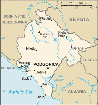 |
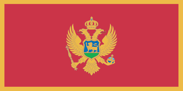
| The national flag of Montenegro | Borderline map of Montenegro |
| Flag description: a red field bordered by a narrow golden-yellow stripe with the Montenegrin coat of arms centered; the arms consist of a double-headed golden eagle – symbolizing the unity of church and state – surmounted by a crown; the eagle holds a golden scepter in its right claw and a blue orb in its left; the breast shield over the eagle shows a golden lion passant on a green field in front of a blue sky; the lion is a symbol of episcopal authority and harkens back to the three and a half centuries when Montenegro was ruled as a theocracy. | Border length: total: 680 km. Border countries (total: 5): Albania 186 km, Bosnia and Herzegovina 242 km, Croatia 19 km, Kosovo 76 km, Serbia 157 km. |
About Podgorica
Though there may not be a great deal to see in Podgorica, the Montenegrin capital has been attracting an increasing number of backpackers in recent years, and the hostel scene has expanded to accommodate them. It is the newest capital city in Europe, one of the smallest, and, until recently, one of the least visited. It also might be the only European capital in which the river water looks positively drinkable – the city centers on the Morača, a fast-flowing turquoise river edged by parkland and spanned by a couple of pedestrian bridges, one of which – the Gazela – dives down below street level. There is also some impressive fortress that remains in this area, while Gorica Forest Park is worth a visit for its pleasant walking trails; it’s to the north of town, behind the easy-to-find national stadium.
Did you know about Montenegro?
- Montenegro united with Serbia and other states in 1919, to form Yugoslavia. In 2006, Montenegro declared independence from Serbia.
- Dark forests once cloaked Montenegros mountains; its name means Black Mountain.
- Montenegro (“Black Mountain) became one of the worlds newest states after gaining independence from Serbia in 2006.
The tiny state of Crna Gora is better known under its Italian name, Montenegro. The English translation – “Black Mountain” – may sound a little bleak, but Montenegro is a land exploding with color. Carpeted with flowers for much of the year, the country’s muscular peaks dappled with the dark greens of pine, beech, and birch from which turquoise streams rush down to a tantalizingly azure blue sea. Fringing it, the coastline dotted from border to border with beaches of yellow and volcanic grey, and huddles of picturesque, orange-roofed houses – a postcard come to life.
Facts of Montenegro (ME)
Name conventional long form: none, conventional short form: Montenegro, local long form: none, local short form: Crna Gora, former: People’s Republic of Montenegro, Socialist Republic of Montenegro, Republic of Montenegro, etymology: the country’s name locally as well as in most Western European languages means “black mountain” and refers to the dark coniferous forests on Mount Lovcen and the surrounding area
Codes: ISO; ME, Internet; .me
Capital city: Podgorica
Language(s): Serbian 42.9%, Montenegrin (official language) 37%, Bosnian 5.3%, Albanian 5.3%, Serbo-Croat 2%, other 3.5%, unspecified 4% (2011 estimate)
National holiday(s): National Day, 13 July (1878, the day the Berlin Congress recognized Montenegro as the 27th independent state in the world, and 1941, the day the Montenegrins staged an uprising against Nazi occupiers and sided with the partisan Communist movement)
Motto: N/A
Currency: Euro (EUR), since 2002
GPS: 42 30 N, 19 18 E, Podgorica; 42 26 N 19 16 E
Location: Southeastern Europe, between the Adriatic Sea and Serbia
Geography note: strategic location along the Adriatic coast
Land boundaries: Albania 186 km, Bosnia and Herzegovina 242 km, Croatia 19 km, Kosovo 76 km, Serbia 157 km, total: 680 km
Maritime boundaries: Adriatic Sea
Coastline: 293.5 km
Area: total: 13,812 sq km; land: 13,452 sq km, water: 360 sq km (total 5 332,84 mi2), slightly smaller than Connecticut.
Roadways: total: 7,762 km, paved: 7,141 km, unpaved: 621 km (2010)
Waterways: N/A
Local time (capital): UTC+1, 6 hours ahead of Washington DC during Standard Time
Note to the local time: Daylight saving time: +1 hr begins last Sunday in March; ends last Sunday in October
Population in Montenegro: 629 219
Population in Podgorica: 117 875 (including the metropolitan areas)
Urbanization: urban population: 64% of total population (2015)
Major urban areas population: PODGORICA (capital) 165,000 (2014)
Population growth rate: -0.35% (2016 estimate)
Birth rate: 10.2 births / 1,000 population (2016 estimate)
Death rate: 9.6 deaths / 1,000 population (2016 estimate)
Age structure: 0-14 years: 15.13% (male 47,983 / female 49,527) 15-24 years: 9.92% (male 29,003 / female 34,907) 25-54 years: 46.83% (male 163,055 / female 138,792) 55-64 years: 13.37% (male 42,998 / female 43,168) 65 years and over: 14.76% (male 38,014 / female 57,131) (2016 estimate)
Median age: total: 40.2 years; male: 39.3 years, female: 41.3 years (2016 estimate)
Ethnic groups: Montenegrin 45%, Serbian 28.7%, Bosniak 8.7%, Albanian 4.9%, Muslim 3.3%, Roma 1%, Croat 1%, other 2.6%, unspecified 4.9% (2011 estimate)
Religions: Orthodox 72.1%, Muslim 19.1%, Catholic 3.4%, atheist 1.2%, other 1.5%, unspecified 2.6% (2011 estimate)
Government type: Parliamentary republic
Legal system: civil law
National anthem: Oj, svijetla majska zoro (Oh, Bright Dawn of May)
Known national hazards: destructive earthquakes
Major infectious diseases: The degree of risk(s): intermediatefood or waterborne diseases: bacterial diarrheavectorborne disease: Crimean-Congo hemorrhagic fever (2016)
Land use: agricultural land: 38.2%; arable land 12.9%; permanent crops 1.2%; permanent pasture 24.1%; forest: 40.4%; other: 21.4% (2011 estimate)
Agricultural products: tobacco, potatoes, citrus fruits, olives, grapes; sheep
Industries: steelmaking, aluminum, agricultural processing, consumer goods, tourism
Export commodities: N/A
Main export partners: Croatia 22.7%, Serbia 22.7%, Slovenia 7.8% (2012 estimate)
Import commodities: N/A
Main import partners: Serbia 29.3%, Greece 8.7%, China 7.1% (2012 estimate)
Navigate the countries in Europe faster and easier while driving, use the interactive Google maps for your driving directions. The continuously updated database contains over 220 countries and territories digitally mapped, hundreds of millions of businesses and places around the world positioned on the map.
Get fresh GPS navigation, traffic, and transit information – no matter what part of Montenegro, Podgorica, any other city and country in Europe, or the world you’re in.
Do you like this Montenegro information page? Please don’t forget to share it with others! Thank you.