Mauritania Google maps and Driving Directions
Get free driving directions, Google maps, traffic information for Mauritania, and Nouakchott (GPS: 18 04 N 15 58 W), the capital city of the country located in (the) Western Africa, bordering the North Atlantic Ocean, between Senegal and Western Sahara.
Find any address in Nouakchott on the Google map of Mauritania (MR) with ease or calculate your up to date itinerary to and from Mauritania or its neighboring counties like Algeria, Mali, Senegal.
Sightseeing and exploring in Africa starts here, thanks to Google because its Earth Engine combines a multi-petabyte catalog of updated satellite imagery and geospatial datasets with planetary-scale analysis capabilities. Wonder the world, use the satellite map function of the Google maps to explore or see differences on the Earth’s surface, inland, or the surrounding areas of Mauritania.
Google Maps Mauritania
Two-thirds of Mauritanias territory is desert the only productive land is that drained by the Senegal River. The country has taken a strongly Arab direction since 1964.
Mauritania is mostly barren, flat plains of the Sahara; some central hills.
The map above fully covers Mauritania with its road routes from cities to towns, road intersections in any region, provinces, prefectures, also with free driving directions in Nouakchott or to the neighboring towns and countries. To look at the detailed map about a particular quarter in Nouakchott, please click on the area and zoom to the place you are interested in the Google maps of Mauritania (MR).
Be creative, use the extras of this Google map; This is a detailed, clear, zoomable, large road map of Mauritania with its administrative divisions; 15 regions (wilayas, singular – wilaya); Adrar, Assaba, Brakna, Dakhlet Nouadhibou, Gorgol, Guidimaka, Hodh ech Chargui, Hodh El Gharbi, Inchiri, Nouakchott Nord, Nouakchott Ouest, Nouakchott Sud, Tagant, Tiris Zemmour, Trarza.
The interactive map above is also may be used as the satellite map of Mauritania, or as a reverse search map for finding an address from its GPS coordinates.
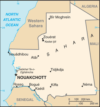
Mauritania located in Western Africa, bordering the North Atlantic Ocean, between Senegal and Western Sahara.
Mauritania (area: 1 025 520 sq km / 395 955,32 sq mi), where the official language is Arabic, lying in Africa and using the currency; Mauritanian ouguiya (MRO), since 1973, set their clock to UTC 0. That means they are 5 hours ahead of Washington DC during Standard Time in Nouakchott, the capital. Note to the time difference: N/A.
The climate in Mauritania; The climate is generally hot and dry, aggravated by the dusty harmattan wind. Summer rain in the south, virtually none in the north.
Geography in a nutshell; The Sahara, barren except for some scattered oases, covers the north. Savanna lands lie to the south.
Click here for more detailed information about Mauritania.
Driving directions Mauritania
The Google maps and Google Satellite maps of Mauritania above showing the country, located next to Algeria, Mali, Senegal. For your further reference, the latitude and longitude coordinates of Mauritania are 20 00 N, 12 00 W , while the capital, Nouakchott found at 18 04 N 15 58 W.
When you are traveling around Mauritania, Nouakchott, or its other cities, use this routing tool, providing up to date route planning service free of charge.
Look no further; get accurate driving directions in Mauritania, Africa, by filling the route planner form below.
Since Google acquired and introduced its digitalized maps in 2004, you’re probably familiar with its base functions, like finding an address or driving directions to locations. Still, Google maps also accommodate bicyclists, pedestrians, and also public transportation with special directions and customizable routes.
About Mauritania and the capital, Nouakchott
 |
 |
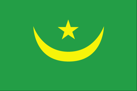
| The national flag of Mauritania | Borderline map of Mauritania |
| Flag description: green with a yellow five-pointed star above a yellow, horizontal crescent; the closed side of the crescent is down; the crescent, star, and color green are traditional symbols of Islam; green also represents hope for a bright future; the yellow color stands for the sands of the Sahara. | Border length: total: 5,002 km. Border countries (total: 4): Algeria 460 km, Mali 2,236 km, Senegal 742 km, Western Sahara 1,564 km. |
Did you know about Mauritania?
- Mauritania became fully independent from France in 1960. From 1976-1979 it occupied part of Western Sahara; now occupied by Morocco.
- Slavery officially became illegal in Mauritania in 1980, but de facto slavery still persists.
- Lying to the north of the Niger Valley on the Atlantic coast, Mauritania has a major offshore fishing industry.
Facts of Mauritania (MR)
Name conventional long form: Islamic Republic of Mauritania, conventional short form: Mauritania, local long form: Al Jumhuriyah al Islamiyah al Muritaniyah, local short form: Muritaniyah, etymology: named for the ancient Kingdom of Mauretania (3rd century B.C. to 1st century A.D.), which existed further north in present-day Morocco; the name derives from the Mauri (Moors), the Berber-speaking peoples of northwest Africa
Codes: ISO; MR, Internet; .mr
Capital city: Nouakchott
Language(s): Arabic (official language and national), Pulaar, Soninke, Wolof (all national languages), French. Note: the spoken Arabic in Mauritania differs considerably from the modern standard Arabic used for official language written purposes or in the media; the Mauritanian dialect, which incorporates many Berber words, is referred to as Hassaniya
National holiday(s): Independence Day, 28 November (1960)
Motto: Honor, Fraternity, Justice
Currency: Mauritanian ouguiya (MRO), since 1973
GPS: 20 00 N, 12 00 W, Nouakchott; 18 04 N 15 58 W
Location: Western Africa, bordering the North Atlantic Ocean, between Senegal and Western Sahara
Geography note: Mauritania is considered both a part of North Africa’s Maghreb region and West Africa’s Sahel region; most of the population is concentrated in the cities of Nouakchott and Nouadhibou and along the Senegal River in the southern part of the country
Land boundaries: Algeria 460 km, Mali 2,236 km, Senegal 742 km, Western Sahara 1,564 km, total: 5,002 km
Maritime boundaries: N/A
Coastline: 754 km
Area: total: 1,030,700 sq km; land: 1,030,700 sq km, water: 0 sq km (total 395 955,32 mi2), slightly larger than three times the size of New Mexico.
Roadways: total: 10,628 km, paved: 3,158 km, unpaved: 7,470 km (2010)
Waterways: (some navigation possible on the Senegal River) (2011)
Local time (capital): UTC 0, 5 hours ahead of Washington DC during Standard Time
Note to the local time: N/A
Population in Mauritania: 4 540 068
Population in Nouakchott: 661 400 (including the metropolitan areas)
Urbanization: urban population: 59.9% of total population (2015)
Major urban areas population: NOUAKCHOTT (capital) 968,000 (2015)
Population growth rate: 2.2% (2016 estimate)
Birth rate: 30.9 births / 1,000 population (2016 estimate)
Death rate: 8.1 deaths / 1,000 population (2016 estimate)
Age structure: 0-14 years: 38.87% (male 717,790 / female 711,694) 15-24 years: 19.86% (male 357,460 / female 372,744) 25-54 years: 32.96% (male 561,341 / female 650,580) 55-64 years: 4.61% (male 76,372 / female 93,065) 65 years and over: 3.71% (male 57,814 / female 78,433) (2016 estimate)
Median age: total: 20.3 years; male: 19.3 years, female: 21.2 years (2016 estimate)
Ethnic groups: black Moors (Haratines – Arab-speaking slaves, former slaves, and their descendants of African origin, enslaved by white Moors) 40%, white Moors (of Arab-Berber descent, known as Bidhan) 30%, black Africans (non-Arabic speaking, Halpulaar, Soninke, Wolof, and Bamara ethnic groups) 30%
Religions: Muslim (official) 100%
Government type: Unitary semi-presidential republic
Legal system: mixed legal system of Islamic and French civil law
National anthem: Nachid al-watani
Known national hazards: hot, dry, dust/sand-laden sirocco wind primarily in March and April; periodic droughts
Major infectious diseases: The degree of risk(s): very high food or waterborne diseases: bacterial and protozoal diarrhea, hepatitis A, and typhoid fever vectorborne diseases: malaria and dengue feverrespiratory disease: meningococcal meningitisanimal contact disease: rabies (2016)
Land use: agricultural land: 38.5%; arable land 0.4%; permanent crops 0%; permanent pasture 38.1%; forest: 0.2%; other: 61.3% (2011 estimate)
Agricultural products: dates, millet, sorghum, rice, corn; cattle, sheep
Industries: fish processing, oil production, mining (iron ore, gold, copper). Note: gypsum deposits have never been exploited
Export commodities: iron ore, fish and fish products, gold, copper, petroleum
Main export partners: China 32.7%, Switzerland 11.1%, Spain 8.6%, Italy 6.7%, Cote dIvoire 6.6%, Japan 5.7% (2015)
Import commodities: machinery and equipment, petroleum products, capital goods, foodstuffs, consumer goods
Main import partners: China 25.5%, Algeria 8.4%, France 6.3%, Morocco 5.1%, Spain 4.8%, Brazil 4.5%, US 4% (2015)
Navigate the countries in Africa faster and easier while driving, use the interactive Google maps for your driving directions. The continuously updated database contains over 220 countries and territories digitally mapped, hundreds of millions of businesses and places around the world positioned on the map.
Get fresh GPS navigation, traffic, and transit information – no matter what part of Mauritania, Nouakchott, any other city and country in Africa, or the world you’re in.
Do you like this Mauritania information page? Please don’t forget to share it with others! Thank you.