Algeria Google maps and Driving Directions
Get free driving directions, Google maps, traffic information for Algeria, and Algiers (GPS: 36 45 N 3 03 E), the capital city of the country located in (the) Northern Africa, bordering the Mediterranean Sea, between Morocco and Tunisia.
Find any address in Algiers on the Google map of Algeria (DZ) with ease or calculate your up to date itinerary to and from Algeria or its neighboring counties like Libya, Mali, Mauritania, Morocco, Niger, Tunisia.
Sightseeing and exploring in Africa starts here, thanks to Google because its Earth Engine combines a multi-petabyte catalog of updated satellite imagery and geospatial datasets with planetary-scale analysis capabilities. Wonder the world, use the satellite map function of the Google maps to explore or see differences on the Earth’s surface, inland, or the surrounding areas of Algeria.
Google Maps Algeria
Africas second-largest country, Algeria won independence from France in 1962. Today, national reconciliation is key to recovery from a conflict launched by Islamic extremists in 1992.
Algeria is mostly high plateau and desert; some mountains; narrow, discontinuous coastal plain.
The map above fully covers Algeria with its road routes from cities to towns, road intersections in any region, provinces, prefectures, also with free driving directions in Algiers or to the neighboring towns and countries. To look at the detailed map about a particular quarter in Algiers, please click on the area and zoom to the place you are interested in the Google maps of Algeria (DZ).
Be creative, use the extras of this Google map; This is a detailed, clear, zoomable, large road map of Algeria with its administrative divisions; 48 provinces (wilayas, singular – wilaya); Adrar, Ain Defla, Ain Temouchent, Alger, Annaba, Batna, Bechar, Bejaia, Biskra, Blida, Bordj Bou Arreridj, Bouira, Boumerdes, Chlef, Constantine, Djelfa, El Bayadh, El Oued, El Tarf, Ghardaia, Guelma, Illizi, Jijel, Khenchela, Laghouat, Mascara, Medea, Mila, Mostaganem, M’Sila, Naama, Oran, Ouargla, Oum el Bouaghi, Relizane, Saida, Setif, Sidi Bel Abbes, Skikda, Souk Ahras, Tamanrasset, Tebessa, Tiaret, Tindouf, Tipaza, Tissemsilt, Tizi Ouzou, Tlemcen.
The interactive map above is also may be used as the satellite map of Algeria, or as a reverse search map for finding an address from its GPS coordinates.
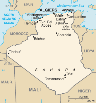
Nearly four times the size of Texas and the largest country on the continent, Algeria is bordered on the west by Morocco and Western Sahara and on the east by Tunisia and Libya. The Mediterranean Sea is to the north, and to the south are Mauritania, Mali, and Niger. The Saharan region, which is 85% of the country, is almost completely uninhabited. The highest point is Mount Tahat in the Sahara, which rises 9,850 ft (3,000 m).
Algeria (area: 2 381 740 sq km / 919 594,58 sq mi), where the official language is Arabic, Berber, lying in Africa and using the currency; Algerian dinar (DZD), since 1964, set their clock to UTC+1. That means they are 6 hours ahead of Washington DC during Standard Time in Algiers, the capital. Note to the time difference: N/A.
The climate in Algeria; Coastal areas are warm and temperate, with most rainfall during the mild winters. The south is very hot, with negligible rainfall.
Geography in a nutshell; 85% of the country lies within the Sahara Desert. Fertile coastal region with plains and hills rises from the southeast to the Atlas Mountains.
Click here for more detailed information about Algeria.
Driving directions Algeria
The Google maps and Google Satellite maps of Algeria above showing the country, located next to Libya, Mali, Mauritania, Morocco, Niger, Tunisia. For your further reference, the latitude and longitude coordinates of Algeria are 28 00 N, 3 00 E , while the capital, Algiers found at 36 45 N 3 03 E.
When you are traveling around Algeria, Algiers, or its other cities, use this routing tool, providing up to date route planning service free of charge.
Look no further; get accurate driving directions in Algeria, Africa, by filling the route planner form below.
Since Google acquired and introduced its digitalized maps in 2004, you’re probably familiar with its base functions, like finding an address or driving directions to locations. Still, Google maps also accommodate bicyclists, pedestrians, and also public transportation with special directions and customizable routes.
About Algeria and the capital, Algiers
 |
 |
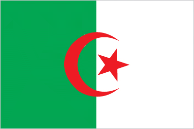
| The national flag of Algeria | Borderline map of Algeria |
| Flag description: two equal vertical bands of green (hoist side) and white; a red, five-pointed star within a red crescent centered over the two-color boundary; the colors represent Islam (green), purity and peace (white), and liberty (red); the crescent and star are also Islamic symbols, but the crescent is more closed than those of other Muslim countries because Algerians believe the long crescent horns bring happiness. | Border length: total: 6,734 km. Border countries (total: 7): Libya 989 km, Mali 1,359 km, Mauritania 460 km, Morocco 1,900 km, Niger 951 km, Tunisia 1,034 km, Western Sahara 41 km. |
Did you know about Algeria?
- Algeria occupied by the French from 1830. Independence achieved in 1962 after a long struggle led by the National Liberation Front.
- The worlds highest dunes are located in the deserts of east central Algeria.
- Algeria is a major exporter of natural gas to Europe and has reserves of oil, iron ore, and phosphates.
Facts of Algeria (DZ)
Name conventional long form: People’s Democratic Republic of Algeria, conventional short form: Algeria, local long form: Al Jumhuriyah al Jaza’iriyah ad Dimuqratiyah ash Sha’biyah, local short form: Al Jaza’ir, etymology: the country name derives from the capital city of Algiers
Codes: ISO; DZ, Internet; .dz
Capital city: Algiers
Language(s): Arabic (official language), French (lingua franca), Berber or Tamazight (official language); dialects include Kabyle Berber (Taqbaylit), Shawiya Berber (Tacawit), Mzab Berber, Tuareg Berber (Tamahaq)
National holiday(s): Revolution Day, 1 November (1954)
Motto: By the people and for the people
Currency: Algerian dinar (DZD), since 1964
GPS: 28 00 N, 3 00 E, Algiers; 36 45 N 3 03 E
Location: Northern Africa, bordering the Mediterranean Sea, between Morocco and Tunisia
Geography note: largest country in Africa
Land boundaries: Libya 989 km, Mali 1,359 km, Mauritania 460 km, Morocco 1,900 km, Niger 951 km, Tunisia 1,034 km, Western Sahara 41 km, total: 6,734 km
Maritime boundaries: N/A
Coastline: 998 km
Area: total: 2,381,741 sq km; land: 2,381,741 sq km, water: 0 sq km (total 919 594,58 mi2), slightly less than 3.5 times the size of Texas.
Roadways: total: 113,655 km, paved: 87,605 km (includes 645 km of expressways), unpaved: 26,050 km (2010)
Waterways: N/A
Local time (capital): UTC+1, 6 hours ahead of Washington DC during Standard Time
Note to the local time: N/A
Population in Algeria: 42 008 054
Population in Algiers: 3 917 000 (including the metropolitan areas)
Urbanization: urban population: 70.7% of total population (2015)
Major urban areas population: ALGIERS (capital) 2.594 million; Oran 858,000 (2015)
Population growth rate: 1.77% (2016 estimate)
Birth rate: 23 births / 1,000 population (2016 estimate)
Death rate: 4.3 deaths / 1,000 population (2016 estimate)
Age structure: 0-14 years: 29.06% (male 5,991,164 / female 5,709,616) 15-24 years: 15.95% (male 3,287,448 / female 3,136,624) 25-54 years: 42.88% (male 8,737,944 / female 8,526,137) 55-64 years: 6.61% (male 1,349,291 / female 1,312,339) 65 years and over: 5.5% (male 1,027,126 / female 1,186,022) (2016 estimate)
Median age: total: 27.8 years; male: 27.5 years, female: 28.1 years (2016 estimate)
Ethnic groups: Arab-Berber 99%, European less than 1%note: although almost all Algerians are Berber in origin (not Arab), only a minority identify themselves as Berber, about 15% of the total population; these people live mostly in the mountainous region of Kabylie east of Algiers; the Berbers are also Muslim but identify with their Berber rather than Arab cultural heritage; Berbers have long agitated, sometimes violently, for autonomy; the government is unlikely to grant autonomy but has offered to begin sponsoring teaching Berber language in schools
Religions: Muslim (official; predominantly Sunni) 99%, other (includes Christian and Jewish)
Government type: Unitary semi-presidential people’s republic
Legal system: mixed legal system of French civil law and Islamic law; judicial review of legislative acts in ad hoc Constitutional Council composed of various public officials including several Supreme Court justices
National anthem: Kassaman (We Pledge)
Known national hazards: mountainous areas subject to severe earthquakes; mudslides and floods in rainy season
Major infectious diseases: N/A
Land use: agricultural land: 17.3%; arable land 3.1%; permanent crops 0.4%; permanent pasture 13.8%; forest: 0.6%; other: 82% (2011 estimate)
Agricultural products: wheat, barley, oats, grapes, olives, citrus, fruits; sheep, cattle
Industries: petroleum, natural gas, light industries, mining, electrical, petrochemical, food processing
Export commodities: petroleum, natural gas, and petroleum products 97% (2009 estimate)
Main export partners: Spain 18.8%, France 11.2%, US 8.8%, Italy 8.7%, UK 7.1%, Brazil 5.2%, Tunisia 4.9%, Germany 4.5% (2015)
Import commodities: capital goods, foodstuffs, consumer goods
Main import partners: China 15.6%, France 14.4%, Italy 9.4%, Spain 7.4%, Germany 5.6%, Russia 4.1% (2015)
Navigate the countries in Africa faster and easier while driving, use the interactive Google maps for your driving directions. The continuously updated database contains over 220 countries and territories digitally mapped, hundreds of millions of businesses and places around the world positioned on the map.
Get fresh GPS navigation, traffic, and transit information – no matter what part of Algeria, Algiers, any other city and country in Africa, or the world you’re in.
Do you like this Algeria information page? Please don’t forget to share it with others! Thank you.