Togo Google maps and Driving Directions
Get free driving directions, Google maps, traffic information for Togo, and Lomé (GPS: 6 07 N 1 13 E), the capital city of the country located in (the) Western Africa, bordering the Bight of Benin, between Benin and Ghana.
Find any address in Lomé on the Google map of Togo (TG) with ease or calculate your up to date itinerary to and from Togo or its neighboring counties like Benin, Burkina Faso, Ghana.
Sightseeing and exploring in Africa starts here, thanks to Google because its Earth Engine combines a multi-petabyte catalog of updated satellite imagery and geospatial datasets with planetary-scale analysis capabilities. Wonder the world, use the satellite map function of the Google maps to explore or see differences on the Earth’s surface, inland, or the surrounding areas of Togo.
Google Maps Togo
Togo lies sandwiched between Ghana and Benin in west Africa. General Eyadema ruled from 19672005; his son succeeded him. Lomé port is an important entrepôt for regional trade.
Togo is gently rolling savanna in north; central hills; southern plateau; low coastal plain with extensive lagoons and marshes.
The map above fully covers Togo with its road routes from cities to towns, road intersections in any region, provinces, prefectures, also with free driving directions in Lomé or to the neighboring towns and countries. To look at the detailed map about a particular quarter in Lome, please click on the area and zoom to the place you are interested in the Google maps of Togo (TG).
Be creative, use the extras of this Google map; This is a detailed, clear, zoomable, large road map of Togo with its administrative divisions; 5 regions (regions, singular – region); Centrale, Kara, Maritime, Plateaux, Savanes.
The interactive map above is also may be used as the satellite map of Togo, or as a reverse search map for finding an address from its GPS coordinates.
Togo, twice the size of Maryland, is on the south coast of West Africa bordering on Ghana to the west, Burkina Faso to the north, and Benin to the east. The Gulf of Guinea coastline, only 32 mi long (51 km), is low and sandy. The only port is at Lomé. The Togo hills traverse the central section.
Togo (area: 56 785 sq km / 21 924,80 sq mi), where the official language is French, lying in Africa and using the currency; West African CFA franc (XOF), set their clock to UTC 0. That means they are 5 hours ahead of Washington DC during Standard Time in Lome, the capital. Note to the time difference: N/A.
The climate in Togo; Coast hot and humid; drier inland. Rainy season MarchJuly, with heaviest falls in the west.
Geography in a nutshell; Central forested region bounded by savanna lands to the north and south. Mountain range stretches southwest to northeast.
Click here for more detailed information about Togo.
Driving directions Togo
The Google maps and Google Satellite maps of Togo above showing the country, located next to Benin, Burkina Faso, Ghana. For your further reference, the latitude and longitude coordinates of Togo are 8 00 N, 1 10 E , while the capital, Lome found at 6 07 N 1 13 E.
When you are traveling around Togo, Lome, or its other cities, use this routing tool, providing up to date route planning service free of charge.
Look no further; get accurate driving directions in Togo, Africa, by filling the route planner form below.
Since Google acquired and introduced its digitalized maps in 2004, you’re probably familiar with its base functions, like finding an address or driving directions to locations. Still, Google maps also accommodate bicyclists, pedestrians, and also public transportation with special directions and customizable routes.
About Togo and the capital, Lomé
 |
 |
| The national flag of Togo | Borderline map of Togo |
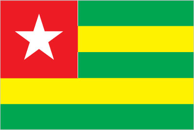
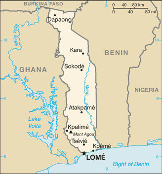
| Flag description: five equal horizontal bands of green (top and bottom) alternating with yellow; a white five-pointed star on a red square is in the upper hoist-side corner; the five horizontal stripes stand for the five different regions of the country; the red square is meant to express the loyalty and patriotism of the people; green symbolizes hope, fertility, and agriculture; yellow represents mineral wealth and faith that hard work and strength will bring prosperity; the star symbolizes life, purity, peace, dignity, and Togo’s independence. Note: uses the popular Pan-African colors of Ethiopia. | Border length: total: 1,880 km. Border countries (total: 3): Benin 651 km, Burkina Faso 131 km, Ghana 1,098 km. |
Did you know about Togo?
- Togo once was a German colony, divided between France and Britain in 1914. The French part became independent, as Togo, in 1960.
- The “Nana Benz, the entrepreneurial market-women of Lomé, control Togos retail trade.
- This long, thin country is self-sufficient in basic foodstuffs, growing corn, yams, rice, and cassava to eat, and cocoa, coffee, and cotton to export.
Facts of Togo (TG)
Name conventional long form: Togolese Republic, conventional short form: Togo, local long form: Republique Togolaise, local short form: none, former: French Togoland, etymology: derived from the Ewe words “to” (water) and “go” (shore) to give the sense of “by the water”; originally, this designation applied to the town of Togo (now Togoville) on the northern shore of Lake Togo, but the name was eventually extended to the entire nation
Codes: ISO; TG, Internet; .tg
Capital city: Lomé
Language(s): French (official language, the language of commerce), Ewe and Mina (the two major African languages in the south), Kabye (sometimes spelled Kabiye) and Dagomba (the two major African languages in the north)
National holiday(s): Independence Day, 27 April (1960)
Motto: Travail, Liberté, Patrie (Work, Liberty, Homeland)
Currency: West African CFA franc (XOF)
GPS: 8 00 N, 1 10 E, Lomé; 6 07 N 1 13 E
Location: Western Africa, bordering the Bight of Benin, between Benin and Ghana
Geography note: the country’s length allows it to stretch through six distinct geographic regions; climate varies from tropical to savanna
Land boundaries: Benin 651 km, Burkina Faso 131 km, Ghana 1,098 km, total: 1,880 km
Maritime boundaries: N/A
Coastline: 56 km
Area: total: 56,785 sq km; land: 54,385 sq km, water: 2,400 sq km (total 21 924,80 mi2), slightly smaller than West Virginia.
Roadways: total: 11,652 km, paved: 2,447 km, unpaved: 9,205 km (2007)
Waterways: 50 km (seasonally navigable by small craft on the Mono River depending on rainfall) (2011)
Local time (capital): UTC 0, 5 hours ahead of Washington DC during Standard Time
Note to the local time: N/A
Population in Togo: 7 990 926
Population in Lome: 1 524 000 (including the metropolitan areas)
Urbanization: urban population: 40% of total population (2015)
Major urban areas population: LOME (capital) 956,000 (2015)
Population growth rate: 2.66% (2016 estimate)
Birth rate: 33.7 births / 1,000 population (2016 estimate)
Death rate: 7.1 deaths / 1,000 population (2016 estimate)
Age structure: 0-14 years: 40.44% (male 1,573,363 / female 1,563,267) 15-24 years: 19.34% (male 749,002 / female 751,571) 25-54 years: 32.58% (male 1,255,524 / female 1,271,804) 55-64 years: 4.27% (male 156,249 / female 175,089) 65 years and over: 3.37% (male 112,845 / female 148,223) (2016 estimate)
Median age: total: 19.7 years; male: 19.4 years, female: 20 years (2016 estimate)
Ethnic groups: African (37 tribes; largest and most important are Ewe, Mina, and Kabre) 99%, European and Syrian-Lebanese less than 1%
Religions: Christian 29%, Muslim 20%, indigenous beliefs 51%
Government type: Presidential republic
Legal system: customary law system
National anthem: Salut á toi, pays de nos aieux (Hail to thee, land of our forefathers)
Known national hazards: hot, dry harmattan wind can reduce visibility in north during winter; periodic droughts
Major infectious diseases: The degree of risk(s): very high food or waterborne diseases: bacterial and protozoal diarrhea, hepatitis A, and typhoid fever vectorborne diseases: malaria, dengue fever, and yellow feverrespiratory disease: meningococcal meningitiswater contact disease: schistosomiasis animal contact disease: rabies (2016)
Land use: agricultural land: 67.4%; arable land 45.2%; permanent crops 3.8%; permanent pasture 18.4%; forest: 4.9%; other: 27.7% (2011 estimate)
Agricultural products: coffee, cocoa, cotton, yams, cassava (manioc, tapioca), corn, beans, rice, millet, sorghum; livestock; fish
Industries: phosphate mining, agricultural processing, cement, handicrafts, textiles, beverages
Export commodities: reexports, cotton, phosphates, coffee, cocoa
Main export partners: India 14.6%, Burkina Faso 11.3%, China 11.3%, Benin 9.6%, Ghana 9%, Lebanon 8.3%, Nigeria 6.1%, Niger 5.9% (2015)
Import commodities: machinery and equipment, foodstuffs, petroleum products
Main import partners: China 22.9%, Belgium 20.3%, Netherlands 11.9%, France 6.6%, India 4.8%, Singapore 4.4% (2015)
Navigate the countries in Africa faster and easier while driving, use the interactive Google maps for your driving directions. The continuously updated database contains over 220 countries and territories digitally mapped, hundreds of millions of businesses and places around the world positioned on the map.
Get fresh GPS navigation, traffic, and transit information – no matter what part of Togo, Lomé, any other city and country in Africa, or the world you’re in.
Do you like this Togo information page? Please don’t forget to share it with others! Thank you.