Cameroon Google maps and Driving Directions
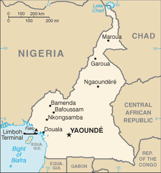
Get free driving directions, Google maps, traffic information for Cameroon, and Yaoundé (GPS: 3 52 N 11 31 E), the capital city of the country located in (the) Central Africa, bordering the Bight of Biafra, between Equatorial Guinea and Nigeria.
Find any address in Yaoundé on the Google map of Cameroon (CM) with ease or calculate your up to date itinerary to and from Cameroon or its neighboring counties like Central African Republic, Chad, Equatorial Guinea, Gabon, Nigeria, Republic of the Congo.
Sightseeing and exploring in Africa starts here, thanks to Google because its Earth Engine combines a multi-petabyte catalog of updated satellite imagery and geospatial datasets with planetary-scale analysis capabilities. Wonder the world, use the satellite map function of the Google maps to explore or see differences on the Earth’s surface, inland, or the surrounding areas of Cameroon.
Google Maps Cameroon
Situated in the corner of the Gulf of Guinea, Cameroon was effectively a one-party state for 30 years. Multiparty elections, since 1992, regularly return that same party to power.
Cameroon is diverse, with coastal plain in southwest, dissected plateau in center, mountains in west, plains in north.
The map above fully covers Cameroon with its road routes from cities to towns, road intersections in any region, provinces, prefectures, also with free driving directions in Yaoundé or to the neighboring towns and countries. To look at the detailed map about a particular quarter in Yaounde, please click on the area and zoom to the place you are interested in the Google maps of Cameroon (CM).
Be creative, use the extras of this Google map; This is a detailed, clear, zoomable, large road map of Cameroon with its administrative divisions; 10 regions (regions, singular – region); Adamaoua, Centre, East (Est), Far North (Extreme-Nord), Littoral, North (Nord), North-West (Nord-Ouest), West (Ouest), South (Sud), South-West (Sud-Ouest).
The interactive map above is also may be used as the satellite map of Cameroon, or as a reverse search map for finding an address from its GPS coordinates.
Cameroon is a Central African nation on the Gulf of Guinea, bordered by Nigeria, Chad, the Central African Republic, the Republic of Congo, Equatorial Guinea, and Gabon. It is nearly twice the size of Oregon. Mount Cameroon (13,350 ft 4,069 m), near the coast, is the highest elevation in the country. The main rivers are the Benue, Nyong, and Sanaga.
Cameroon (area: 475 442 sq km / 183 569,11 sq mi), where the official language is English, French, lying in Africa and using the currency; Central African CFA franc (XAF), set their clock to UTC+1. That means they are 6 hours ahead of Washington DC during Standard Time in Yaounde, the capital. Note to the time difference: N/A.
The climate in Cameroon; South is equatorial, with plentiful rainfall, declining inland. Far north is beset by drought.
Geography in a nutshell; Over half the land is forested: equatorial rainforest in north, evergreen forest and wooded savanna in south. Mountains in the west.
Click here for more detailed information about Cameroon.
Driving directions Cameroon
The Google maps and Google Satellite maps of Cameroon above showing the country, located next to Central African Republic, Chad, Equatorial Guinea, Gabon, Nigeria, Republic of the Congo. For your further reference, the latitude and longitude coordinates of Cameroon are 6 00 N, 12 00 E , while the capital, Yaounde found at 3 52 N 11 31 E.
When you are traveling around Cameroon, Yaounde, or its other cities, use this routing tool, providing up to date route planning service free of charge.
Look no further; get accurate driving directions in Cameroon, Africa, by filling the route planner form below.
Since Google acquired and introduced its digitalized maps in 2004, you’re probably familiar with its base functions, like finding an address or driving directions to locations. Still, Google maps also accommodate bicyclists, pedestrians, and also public transportation with special directions and customizable routes.
About Cameroon and the capital, Yaoundé
 |
 |
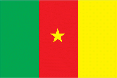
| The national flag of Cameroon | Borderline map of Cameroon |
| Flag description: three equal vertical bands of green (hoist side), red, and yellow, with a yellow five-pointed star centered in the red band; the vertical tricolor recalls the flag of France; red symbolizes unity, yellow the sun, happiness, and the savannahs in the north, and green hope and the forests in the south; the star is referred to as the “star of unity”note: uses the popular Pan-African colors of Ethiopia. | Border length: total: 5,018 km. Border countries (total: 6): Central African Republic 901 km, Chad 1,116 km, Republic of the Congo 494 km, Equatorial Guinea 183 km, Gabon 349 km, Nigeria 1,975 km. |
Did you know about Cameroon?
- Cameroon was originally a German colony, which was partitioned by the French and the British after World War I.
- Cameroons namederives from the Portuguese word camar?es, after the shrimp fished by the early European explorers.
- Heavily wooded Cameroon boasts quality hardwoods, such as ebony, mahogany, and teak, which are greatly sought after by Western furniture-makers.
Facts of Cameroon (CM)
Name conventional long form: Republic of Cameroon, conventional short form: Cameroon, local long form: Republique du Cameroun/Republic of Cameroon, local short form: Cameroun/Cameroon, former: French Cameroon, British Cameroon, Federal Republic of Cameroon, United Republic of Cameroon, etymology: in the 15th century, Portuguese explorers named the area near the mouth of the Wouri River the Rio dos Camaroes (River of Prawns) after the abundant shrimp in the water; over time the designation became Cameroon in English; this is the only instance where a country is named afer a crustacean
Codes: ISO; CM, Internet; .cm
Capital city: Yaoundé
Language(s): 24 major African language groups, English (official language), French (official language)
National holiday(s): State Unification Day (National Day), 20 May (1972)
Motto: Paix, travail, patrie (Peace, Work, Fatherland)
Currency: Central African CFA franc (XAF)
GPS: 6 00 N, 12 00 E, Yaoundé; 3 52 N 11 31 E
Location: Central Africa, bordering the Bight of Biafra, between Equatorial Guinea and Nigeria
Geography note: sometimes referred to as the hinge of Africa; throughout the country there are areas of thermal springs and indications of current or prior volcanic activity; Mount Cameroon, the highest mountain in Sub-Saharan west Africa, is an active volcano
Land boundaries: Central African Republic 901 km, Chad 1,116 km, Republic of the Congo 494 km, Equatorial Guinea 183 km, Gabon 349 km, Nigeria 1,975 km, total: 5,018 km
Maritime boundaries: N/A
Coastline: 402 km
Area: total: 475,440 sq km; land: 472,710 sq km, water: 2,730 sq km (total 183 569,11 mi2), slightly larger than California.
Roadways: total: 51,350 km, paved: 4,108 km, unpaved: 47,242 km, note: there are 28,857 km of national roads (2011)
Waterways: (major rivers in the south, such as the Wouri and the Sanaga, are largely non-navigable; in the north, the Benue, which connects through Nigeria to the Niger River, is navigable in the rainy season only to the port of Garoua) (2010)
Local time (capital): UTC+1, 6 hours ahead of Washington DC during Standard Time
Note to the local time: N/A
Population in Cameroon: 24 678 234
Population in Yaounde: 1 395 200 (including the metropolitan areas)
Urbanization: urban population: 54.4% of total population (2015)
Major urban areas population: YAOUNDE (capital) 3.066 million; Douala 2.943 million (2015)
Population growth rate: 2.58% (2016 estimate)
Birth rate: 35.8 births / 1,000 population (2016 estimate)
Death rate: 9.8 deaths / 1,000 population (2016 estimate)
Age structure: 0-14 years: 42.6% (male 5,228,047 / female 5,149,228) 15-24 years: 19.55% (male 2,393,598 / female 2,368,557) 25-54 years: 30.71% (male 3,762,054 / female 3,718,266) 55-64 years: 3.97% (male 471,306 / female 495,462) 65 years and over: 3.18% (male 360,386 / female 413,899) (2016 estimate)
Median age: total: 18.5 years; male: 18.4 years, female: 18.6 years (2016 estimate)
Ethnic groups: Cameroon Highlanders 31%, Equatorial Bantu 19%, Kirdi 11%, Fulani 10%, Northwestern Bantu 8%, Eastern Nigritic 7%, other African 13%, non-African less than 1%
Religions: Catholic 38.4%, Protestant 26.3%, other Christian 4.5%, Muslim 20.9%, animist 5.6%, other 1%, non-believer 3.2% (2005 estimate)
Government type: Unitary dominant-party presidential republic
Legal system: mixed legal system of English common law, French civil law, and customary law
National anthem: Chant de Ralliement (O Cameroon, Cradle of our Forefathers)
Known national hazards: volcanic activity with periodic releases of poisonous gases from Lake Nyos and Lake Monoun volcanoesvolcanism: Mt. Cameroon (elev. 4,095 m), which last erupted in 2000, is the most frequently active volcano in West Africa; lakes in Oku volcanic field have released fatal levels of gas on occasion, killing some 1,700 people in 1986
Major infectious diseases: The The degree of risk(s): very high food or waterborne diseases: bacterial and protozoal diarrhea, hepatitis A, and typhoid fever vectorborne diseases: malaria, dengue fever, and yellow feverwater contact disease: schistosomiasisrespiratory disease: meningococcal meningitisanimal contact disease: rabies (2016)
Land use: agricultural land: 20.6%; arable land 13.1%; permanent crops 3.3%; permanent pasture 4.2%; forest: 41.7%; other: 37.7% (2011 estimate)
Agricultural products: coffee, cocoa, cotton, rubber, bananas, oilseed, grains, cassava (manioc, tapioca); livestock; timber
Industries: petroleum production and refining, aluminum production, food processing, light consumer goods, textiles, lumber, ship repair
Export commodities: crude oil and petroleum products, lumber, cocoa beans, aluminum, coffee, cotton
Main export partners: China 16.7%, India 15.7%, Spain 6.2%, Belgium 6.1%, France 6.1%, Portugal 5.6%, Netherlands 5%, Italy 5% (2015)
Import commodities: machinery, electrical equipment, transport equipment, fuel, food
Main import partners: China 27.9%, Nigeria 13.9%, France 10.9%, Belgium 4.1% (2015)
Navigate the countries in Africa faster and easier while driving, use the interactive Google maps for your driving directions. The continuously updated database contains over 220 countries and territories digitally mapped, hundreds of millions of businesses and places around the world positioned on the map.
Get fresh GPS navigation, traffic, and transit information – no matter what part of Cameroon, Yaoundé, any other city and country in Africa, or the world you’re in.
Do you like this Cameroon information page? Please don’t forget to share it with others! Thank you.