Equatorial Guinea Google maps and Driving Directions
Get free driving directions, Google maps, traffic information for Equatorial Guinea, and Malabo (GPS: 3 45 N 8 47 E), the capital city of the country located in (the) Central Africa, bordering the Bight of Biafra, between Cameroon and Gabon.
Find any address in Malabo on the Google map of Equatorial Guinea (GQ) with ease or calculate your up to date itinerary to and from Equatorial Guinea or its neighboring counties like Cameroon, Gabon.
Sightseeing and exploring in Africa starts here, thanks to Google because its Earth Engine combines a multi-petabyte catalog of updated satellite imagery and geospatial datasets with planetary-scale analysis capabilities. Wonder the world, use the satellite map function of the Google maps to explore or see differences on the Earth’s surface, inland, or the surrounding areas of Equatorial Guinea.
Google Maps Equatorial Guinea
Comprising the mainland territory of Río Muni and five islands on the west coast of central Africa, Equatorial Guinea, despite its name, lies just north of the equator.
Equatorial Guinea is coastal plains rise to interior hills; islands are volcanic.
The map above fully covers Equatorial Guinea with its road routes from cities to towns, road intersections in any region, provinces, prefectures, also with free driving directions in Malabo or to the neighboring towns and countries. To look at the detailed map about a particular quarter in Malabo, please click on the area and zoom to the place you are interested in the Google maps of Equatorial Guinea (GQ).
Be creative, use the extras of this Google map; This is a detailed, clear, zoomable, large road map of Equatorial Guinea with its administrative divisions; 7 provinces (provincias, singular – provincia); Annobon, Bioko Norte, Bioko Sur, Centro Sur, Kie-Ntem, Litoral, Wele-Nzas.
The interactive map above is also may be used as the satellite map of Equatorial Guinea, or as a reverse search map for finding an address from its GPS coordinates.
Equatorial Guinea, formerly Spanish Guinea, consists of Río Muni (10,045 sq mi 26,117 sq km), on the western coast of Africa, and several islands in the Gulf of Guinea, the largest of which is Bioko (formerly Fernando Po) (785 sq mi 2,033 sq km). The other islands are Annobón, Corisco, Elobey Grande, and Elobey Chico. The total area is twice that of Connecticut.
Equatorial Guinea (area: 28 051 sq km / 10 830,55 sq mi), where the official language is French, Portuguese, Spanish, lying in Africa and using the currency; Central African CFA franc (XAF), set their clock to UTC+1. That means they are 6 hours ahead of Washington DC during Standard Time in Malabo, the capital. Note to the time difference: N/A.
The climate in Equatorial Guinea; The island of Bioko is extremely wet and humid. The mainland is only marginally drier and cooler.
Geography in a nutshell; The islands are mountainous and volcanic. The mainland is lower, with mangrove swamps along the coast.
Click here for more detailed information about Equatorial Guinea.
Driving directions Equatorial Guinea
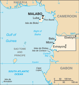
The Google maps and Google Satellite maps of Equatorial Guinea above showing the country, located next to Cameroon, Gabon. For your further reference, the latitude and longitude coordinates of Equatorial Guinea are 2 00 N, 10 00 E , while the capital, Malabo found at 3 45 N 8 47 E.
When you are traveling around Equatorial Guinea, Malabo, or its other cities, use this routing tool, providing up to date route planning service free of charge.
Look no further; get accurate driving directions in Equatorial Guinea, Africa, by filling the route planner form below.
Since Google acquired and introduced its digitalized maps in 2004, you’re probably familiar with its base functions, like finding an address or driving directions to locations. Still, Google maps also accommodate bicyclists, pedestrians, and also public transportation with special directions and customizable routes.
About Equatorial Guinea and the capital, Malabo
 |
 |
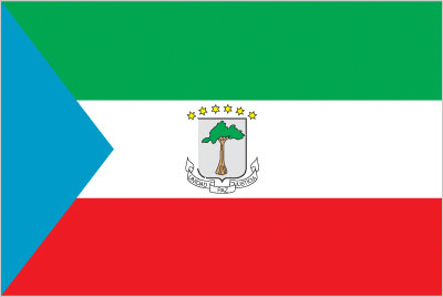
| The national flag of Equatorial Guinea | Borderline map of Equatorial Guinea |
| Flag description: three equal horizontal bands of green (top), white, and red, with a blue isosceles triangle based on the hoist side and the coat of arms centered in the white band; the coat of arms has six yellow six-pointed stars (representing the mainland and five offshore islands) above a gray shield bearing a silk-cotton tree and below which is a scroll with the motto UNIDAD, PAZ, JUSTICIA (Unity, Peace, Justice); green symbolizes the jungle and natural resources, blue represents the sea that connects the mainland to the islands, white stands for peace, and red recalls the fight for independence. | Border length: total: 528 km. Border countries (total: 2): Cameroon 183 km, Gabon 345 km. |
Did you know about Equatorial Guinea?
- Equatorial Guinea includes the former Spanish colonies of Río Muni, the island of Fernando Po (Bioko), and other islands in the Gulf of Guinea.
- In 2003, state radio declared President Obiang Nguema to be “like God in Heaven”.
- This tiny country is mainly tropical rain forest and consists of five offshore islands and a rectangle of land between Cameroon and Gabon.
Facts of Equatorial Guinea (GQ)
Name conventional long form: Republic of Equatorial Guinea, conventional short form: Equatorial Guinea, local long form: Republica de Guinea Ecuatorial/Republique de Guinee Equatoriale, local short form: Guinea Ecuatorial/Guinee Equatoriale, former: Spanish Guinea, etymology: the country named for the Guinea region of West Africa that lies along the Gulf of Guinea and stretches north to the Sahel; the “equatorial” refers to the fact that the country lies just north of the Equator
Codes: ISO; GQ, Internet; .gq
Capital city: Malabo
Language(s): Spanish (official language) 67.6%, other (includes French (official language), Fang, Bubi) 32.4% (1994 census)
National holiday(s): Independence Day, 12 October (1968)
Motto: Unidad, Paz, Justicia (Unity, Peace, Justice)
Currency: Central African CFA franc (XAF)
GPS: 2 00 N, 10 00 E, Malabo; 3 45 N 8 47 E
Location: Central Africa, bordering the Bight of Biafra, between Cameroon and Gabon
Geography note: insular and continental regions widely separated
Land boundaries: Cameroon 183 km, Gabon 345 km, total: 528 km
Maritime boundaries: N/A
Coastline: 296 km
Area: total: 28,051 sq km; land: 28,051 sq km, water: 0 sq km (total 10 830,55 mi2), slightly smaller than Maryland.
Roadways: total: 2,880 km (2000)
Waterways: N/A
Local time (capital): UTC+1, 6 hours ahead of Washington DC during Standard Time
Note to the local time: N/A
Population in Equatorial Guinea: 1 313 894
Population in Malabo: 92 900 (including the metropolitan areas)
Urbanization: urban population: 39.9% of total population (2015)
Major urban areas population: MALABO (capital) 145,000 (2014)
Population growth rate: 2.48% (2016 estimate)
Birth rate: 32.8 births / 1,000 population (2016 estimate)
Death rate: 8 deaths / 1,000 population (2016 estimate)
Age structure: 0-14 years: 40.15% (male 154,896 / female 150,010) 15-24 years: 19.63% (male 75,914 / female 73,194) 25-54 years: 31.94% (male 120,999 / female 121,587) 55-64 years: 4.3% (male 14,052 / female 18,583) 65 years and over: 3.98% (male 12,627 / female 17,589) (2016 estimate)
Median age: total: 19.6 years; male: 19.1 years, female: 20.1 years (2016 estimate)
Ethnic groups: Fang 85.7%, Bubi 6.5%, Mdowe 3.6%, Annobon 1.6%, Bujeba 1.1%, other 1.4% (1994 census)
Religions: nominally Christian and predominantly Roman Catholic, pagan practices
Government type: Presidential republic
Legal system: mixed system of civil and customary law
National anthem: Caminemos pisando las sendas de nuestra inmensa felicidad (Let us walk the paths of our immense felicity)
Known national hazards: violent windstorms; flash floodsvolcanism: Santa Isabel (elev. 3,007 m), which last erupted in 1923, is the country’s only historically active volcano; Santa Isabel, along with two dormant volcanoes, form Bioko Island in the Gulf of Guinea
Major infectious diseases: The degree of risk(s): very high food or waterborne diseases: bacterial and protozoal diarrhea, hepatitis A, and typhoid fever vectorborne disease: malaria and dengue feveranimal contact disease: rabies (2016)
Land use: agricultural land: 10.1%; arable land 4.3%; permanent crops 2.1%; permanent pasture 3.7%; forest: 57.5%; other: 32.4% (2011 estimate)
Agricultural products: coffee, cocoa, rice, yams, cassava (manioc, tapioca), bananas, palm oil nuts; livestock; timber
Industries: petroleum, natural gas, sawmilling
Export commodities: petroleum products, timber
Main export partners: China 16.6%, South Korea 15.1%, Spain 9%, Brazil 8.2%, Netherlands 6.8%, South Africa 6.6%, India 5.8%, UK 5.7%, France 5.7% (2015)
Import commodities: petroleum sector equipment, other equipment, construction materials, vehicles
Main import partners: Netherlands 16.9%, Spain 16.3%, China 14.8%, US 8.9%, Cote dIvoire 6%, France 4.8% (2015)
Navigate the countries in Africa faster and easier while driving, use the interactive Google maps for your driving directions. The continuously updated database contains over 220 countries and territories digitally mapped, hundreds of millions of businesses and places around the world positioned on the map.
Get fresh GPS navigation, traffic, and transit information – no matter what part of Equatorial Guinea, Malabo, any other city and country in Africa, or the world you’re in.
Do you like this Equatorial Guinea information page? Please don’t forget to share it with others! Thank you.