Lesotho Google maps and Driving Directions
Get free driving directions, Google maps, traffic information for Lesotho, and Maseru (GPS: 29 19 S 27 29 E), the capital city of the country located in (the) Southern Africa, an enclave of South Africa.
Find any address in Maseru on the Google map of Lesotho (LS) with ease or calculate your up to date itinerary to and from Lesotho or its neighboring counties like South Africa.
Sightseeing and exploring in Africa starts here, thanks to Google because its Earth Engine combines a multi-petabyte catalog of updated satellite imagery and geospatial datasets with planetary-scale analysis capabilities. Wonder the world, use the satellite map function of the Google maps to explore or see differences on the Earth’s surface, inland, or the surrounding areas of Lesotho.
Google Maps Lesotho
The landlocked Kingdom of Lesotho is entirely surrounded by and economically dependent on South Africa, which even sent in troops to restore calm after rioting in 1998.
Lesotho is mostly highland with plateaus, hills, and mountains.
The map above fully covers Lesotho with its road routes from cities to towns, road intersections in any region, provinces, prefectures, also with free driving directions in Maseru or to the neighboring towns and countries. To look at the detailed map about a particular quarter in Maseru, please click on the area and zoom to the place you are interested in the Google maps of Lesotho (LS).
Be creative, use the extras of this Google map; This is a detailed, clear, zoomable, large road map of Lesotho with its administrative divisions; 10 districts; Berea, Butha-Buthe, Leribe, Mafeteng, Maseru, Mohale’s Hoek, Mokhotlong, Qacha’s Nek, Quthing, Thaba-Tseka.
The interactive map above is also may be used as the satellite map of Lesotho, or as a reverse search map for finding an address from its GPS coordinates.
Mountainous Lesotho, the size of Maryland, is surrounded by the Republic of South Africa.
Lesotho (area: 30 355 sq km / 11 720,13 sq mi), where the official language is English, Sotho, lying in Africa and using the currency; Lesotho loti (LSL), since 1980, set their clock to UTC+2. That means they are 7 hours ahead of Washington DC during Standard Time in Maseru, the capital. Note to the time difference: N/A.
The climate in Lesotho; Temperate. Summers are hot with torrential rain storms. Snow is frequent in the mountains in winter.
Geography in a nutshell; A high mountainous plateau, cut by valleys and ravines. The Maluti Range runs through the center. The Drakensberg Range lies to the east.
Click here for more detailed information about Lesotho.
Driving directions Lesotho
The Google maps and Google Satellite maps of Lesotho above showing the country, located next to South Africa. For your further reference, the latitude and longitude coordinates of Lesotho are 29 30 S, 28 30 E , while the capital, Maseru found at 29 19 S 27 29 E.
When you are traveling around Lesotho, Maseru, or its other cities, use this routing tool, providing up to date route planning service free of charge.
Look no further; get accurate driving directions in Lesotho, Africa, by filling the route planner form below.
Since Google acquired and introduced its digitalized maps in 2004, you’re probably familiar with its base functions, like finding an address or driving directions to locations. Still, Google maps also accommodate bicyclists, pedestrians, and also public transportation with special directions and customizable routes.
About Lesotho and the capital, Maseru
 |
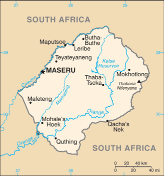 |
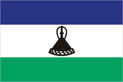
| The national flag of Lesotho | Borderline map of Lesotho |
| Flag description: three horizontal stripes of blue (top), white, and green in the proportions of 3:4:3; the colors represent rain, peace, and prosperity respectively; centered in the white stripe is a black Basotho hat representing the indigenous people; the flag was unfurled in October 2006 to celebrate 40 years of independence. | Border length: total: 1,106 km. Border countries (total: 1): South Africa 1,106 km. |
Did you know about Lesotho?
- Lesotho formerly known as British Basutoland but now known by its Sesotho name. It became independent in 1966.
- Lesotho has one of the highest literacy rates in Africa but one of the highest rates of HIV/AIDS too.
- The lofty lands of Lesotho are all above 3,300ft (1,000m).
Facts of Lesotho (LS)
Name conventional long form: Kingdom of Lesotho, conventional short form: Lesotho, local long form: Kingdom of Lesotho, local short form: Lesotho, former: Basutoland, etymology: the name translates as “Land of the Sesotho speakers”
Codes: ISO; LS, Internet; .ls
Capital city: Maseru
Language(s): Sesotho (official language) (southern Sotho), English (official language), Zulu, Xhosa
National holiday(s): Independence Day, 4 October (1966)
Motto: Khotso Pula Nala (Peace, Rain, Prosperity)
Currency: Lesotho loti (LSL), since 1980
GPS: 29 30 S, 28 30 E, Maseru; 29 19 S 27 29 E
Location: Southern Africa, an enclave of South Africa
Geography note: landlocked, completely surrounded by South Africa; mountainous, more than 80% of the country is 1,800 m above sea level
Land boundaries: South Africa 1,106 km, total: 1,106 km
Maritime boundaries: N/A
Coastline: 0 km (landlocked country)
Area: total: 30,355 sq km; land: 30,355 sq km, water: 0 sq km (total 11 720,13 mi2), slightly smaller than Maryland.
Roadways: total: 5,940 km, paved: 1,069 km, unpaved: 4,871 km (2011)
Waterways: N/A
Local time (capital): UTC+2, 7 hours ahead of Washington DC during Standard Time
Note to the local time: N/A
Population in Lesotho: 2 263 010
Population in Maseru: 173 700 (including the metropolitan areas)
Urbanization: urban population: 27.3% of total population (2015)
Major urban areas population: MASERU (capital) 267,000 (2014)
Population growth rate: 0.3% (2016 estimate)
Birth rate: 25.1 births / 1,000 population (2016 estimate)
Death rate: 14.9 deaths / 1,000 population (2016 estimate)
Age structure: 0-14 years: 32.4% (male 317,933 / female 314,849) 15-24 years: 19.56% (male 181,907 / female 200,113) 25-54 years: 37.58% (male 358,643 / female 375,313) 55-64 years: 5% (male 52,016 / female 45,549) 65 years and over: 5.47% (male 54,466 / female 52,281) (2016 estimate)
Median age: total: 24 years; male: 24 years, female: 24 years (2016 estimate)
Ethnic groups: Sotho 99.7%, Europeans, Asians, and other 0.3%
Religions: Christian 80%, indigenous beliefs 20%
Government type: Unitary parliamentary constitutional monarchy
Legal system: mixed legal system of English common law and Roman-Dutch law; judicial review of legislative acts in High Court and Court of Appeal
National anthem: Lesotho Fatse La Bontata Rona (Lesotho, land of our Fathers)
Known national hazards: periodic droughts
Major infectious diseases: N/A
Land use: agricultural land: 76.1%; arable land 10.1%; permanent crops 0.1%; permanent pasture 65.9%; forest: 1.5%; other: 22.4% (2011 estimate)
Agricultural products: corn, wheat, pulses, sorghum, barley; livestock
Industries: food, beverages, textiles, apparel assembly, handicrafts, construction, tourism
Export commodities: manufactures (clothing, footwear), wool and mohair, food and live animals, electricity, water, diamonds
Main export partners: N/A
Import commodities: food; building materials, vehicles, machinery, medicines, petroleum products
Main import partners: N/A
Navigate the countries in Africa faster and easier while driving, use the interactive Google maps for your driving directions. The continuously updated database contains over 220 countries and territories digitally mapped, hundreds of millions of businesses and places around the world positioned on the map.
Get fresh GPS navigation, traffic, and transit information – no matter what part of Lesotho, Maseru, any other city and country in Africa, or the world you’re in.
Do you like this Lesotho information page? Please don’t forget to share it with others! Thank you.