Swaziland Google maps and Driving Directions
Get free driving directions, Google maps, traffic information for Swaziland, and Mbabane (GPS: 26 19 S 31 08 E), the capital city of the country located in (the) Southern Africa, between Mozambique and South Africa.
Find any address in Mbabane on the Google map of Swaziland (SZ) with ease or calculate your up to date itinerary to and from Swaziland or its neighboring counties like Mozambique, South Africa.
Sightseeing and exploring in Africa starts here, thanks to Google because its Earth Engine combines a multi-petabyte catalog of updated satellite imagery and geospatial datasets with planetary-scale analysis capabilities. Wonder the world, use the satellite map function of the Google maps to explore or see differences on the Earth’s surface, inland, or the surrounding areas of Swaziland.
Google Maps Swaziland
The tiny southern African kingdom of Swaziland is crippled with HIV/AIDS and economically dependent on South Africa. Vocal demands for multiparty democracy have been ignored.
Swaziland is mostly mountains and hills; some moderately sloping plains.
The map above fully covers Swaziland with its road routes from cities to towns, road intersections in any region, provinces, prefectures, also with free driving directions in Mbabane or to the neighboring towns and countries. To look at the detailed map about a particular quarter in Mbabane, please click on the area and zoom to the place you are interested in the Google maps of Swaziland (SZ).
Be creative, use the extras of this Google map; This is a detailed, clear, zoomable, large road map of Swaziland with its administrative divisions; 4 districts; Hhohho, Lubombo, Manzini, Shiselweni.
The interactive map above is also may be used as the satellite map of Swaziland, or as a reverse search map for finding an address from its GPS coordinates.
Swaziland located in Southern Africa, between Mozambique and South Africa.
Swaziland (area: 17 364 sq km / 6 704,28 sq mi), where the official language is English, Swazi, lying in Africa and using the currency; Swazi lilangeni (SZL), since 1974, set their clock to UTC+2. That means they are 7 hours ahead of Washington DC during Standard Time in Mbabane, the capital. Note to the time difference: N/A.
The climate in Swaziland; Temperatures rise and rainfall declines as the land descends eastward, from high to low grassy veld.
Geography in a nutshell; Mainly high plateaus and mountains. Rolling grasslands and low scrub plains to the east. Pine forests on western border.
Click here for more detailed information about Swaziland.
Driving directions Swaziland
The Google maps and Google Satellite maps of Swaziland above showing the country, located next to Mozambique, South Africa. For your further reference, the latitude and longitude coordinates of Swaziland are 26 30 S, 31 30 E , while the capital, Mbabane found at 26 19 S 31 08 E.
When you are traveling around Swaziland, Mbabane, or its other cities, use this routing tool, providing up to date route planning service free of charge.
Look no further; get accurate driving directions in Swaziland, Africa, by filling the route planner form below.
Since Google acquired and introduced its digitalized maps in 2004, you’re probably familiar with its base functions, like finding an address or driving directions to locations. Still, Google maps also accommodate bicyclists, pedestrians, and also public transportation with special directions and customizable routes.
About Swaziland and the capital, Mbabane
 |
 |
| The national flag of Swaziland | Borderline map of Swaziland |
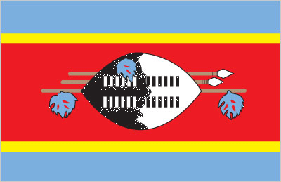
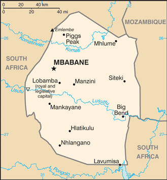
| Flag description: three horizontal bands of blue (top), red (triple width), and blue; the red band is edged in yellow; centered in the red band is a large black and white shield covering two spears and a staff decorated with feather tassels, all placed horizontally; blue stands for peace and stability, red represents past struggles, and yellow the mineral resources of the country; the shield, spears, and staff symbolize protection from the country’s enemies, while the black and white of the shield are meant to portray black and white people living in peaceful coexistence. | Border length: total: 546 km. Border countries (total: 2): Mozambique 108 km, South Africa 438 km. |
Did you know about Swaziland?
- Swaziland was a British Protectorate until 1968. It is now ruled by the Swazi royal family who founded the kingdom in the 19th century.
- Polygamy is practiced in Swaziland when King Sobhuza died in 1982, he left 100 widows.
- The Kingdom of Swaziland relies on sugar cane as its main export.
Facts of Swaziland (SZ)
Name conventional long form: Kingdom of Swaziland, conventional short form: Swaziland, local long form: Umbuso weSwatini, local short form: eSwatini, etymology: “Land of the Swazi” people; the name “Swazi” derives from 19th century King MSWATI II, under whose rule Swazi territory was expanded and unified
Codes: ISO; SZ, Internet; .sz
Capital city: Mbabane
Language(s): English (official language, used for government business), siSwati (official language)
National holiday(s): Independence Day, 6 September (1968)
Motto: Siyinqaba (We are a fortress)
Currency: Swazi lilangeni (SZL), since 1974
GPS: 26 30 S, 31 30 E, Mbabane; 26 19 S 31 08 E
Location: Southern Africa, between Mozambique and South Africa
Geography note: landlocked country; almost completely surrounded by South Africa
Land boundaries: Mozambique 108 km, South Africa 438 km, total: 546 km
Maritime boundaries: N/A
Coastline: 0 km (landlocked country)
Area: total: 17,364 sq km; land: 17,204 sq km, water: 160 sq km (total 6 704,28 mi2), slightly smaller than New Jersey.
Roadways: total: 3,594 km, paved: 1,078 km, unpaved: 2,516 km (2002)
Waterways: N/A
Local time (capital): UTC+2, 7 hours ahead of Washington DC during Standard Time
Note to the local time: N/A
Population in Swaziland: 1 391 385
Population in Mbabane: 66 000 (including the metropolitan areas)
Urbanization: urban population: 21.3% of total population (2015)
Major urban areas population: MBABANE (capital) 66,000 (2014)
Population growth rate: 1.1% (2016 estimate)
Birth rate: 24.3 births / 1,000 population (2016 estimate)
Death rate: 13.4 deaths / 1,000 population (2016 estimate)
Age structure: 0-14 years: 35.5% (male 260,507 / female 254,811) 15-24 years: 22.19% (male 162,880 / female 159,229) 25-54 years: 34.12% (male 256,696 / female 238,471) 55-64 years: 4.28% (male 24,758 / female 37,399) 65 years and over: 3.9% (male 21,842 / female 34,835) (2016 estimate)
Median age: total: 21.4 years; male: 21.2 years, female: 21.7 years (2016 estimate)
Ethnic groups: African 97%, European 3%
Religions: Zionist 40% (a blend of Christianity and indigenous ancestral worship), Roman Catholic 20%, Muslim 10%, other 30% (includes Anglican, Baha’i, Methodist, Mormon, Jewish)
Government type: Unitary parliamentary absolute diarchy
Legal system: mixed legal system of civil, common, and customary law
National anthem: Nkulunkulu Mnikati wetibusiso temaSwati (Oh God, Bestower of the Blessings of the Swazi)
Known national hazards: drought
Major infectious diseases: The degree of risk(s): intermediatefood or waterborne diseases: bacterial diarrhea, hepatitis A, and typhoid fever vectorborne disease: malariawater contact disease: schistosomiasis (2016)
Land use: agricultural land: 68.3%; arable land 9.8%; permanent crops 0.8%; permanent pasture 57.7%; forest: 31.7%; other: 0% (2011 estimate)
Agricultural products: sugarcane, cotton, corn, tobacco, rice, citrus, pineapples, sorghum, peanuts; cattle, goats, sheep
Industries: coal, forestry, sugar, soft drink concentrates, textiles and apparel
Export commodities: soft drink concentrates, sugar, timber, cotton yarn, refrigerators, citrus and canned fruit
Main export partners: N/A
Import commodities: motor vehicles, machinery, transport equipment, foodstuffs, petroleum products, chemicals
Main import partners: N/A
Navigate the countries in Africa faster and easier while driving, use the interactive Google maps for your driving directions. The continuously updated database contains over 220 countries and territories digitally mapped, hundreds of millions of businesses and places around the world positioned on the map.
Get fresh GPS navigation, traffic, and transit information – no matter what part of Swaziland, Mbabane, any other city and country in Africa, or the world you’re in.
Do you like this Swaziland information page? Please don’t forget to share it with others! Thank you.