Tunisia Google maps and Driving Directions
Get free driving directions, Google maps, traffic information for Tunisia, and Tunis (GPS: 36 48 N 10 11 E), the capital city of the country located in (the) Northern Africa, bordering the Mediterranean Sea, between Algeria and Libya.
Find any address in Tunis on the Google map of Tunisia (TN) with ease or calculate your up to date itinerary to and from Tunisia or its neighboring counties like Algeria, Libya.
Sightseeing and exploring in Africa starts here, thanks to Google because its Earth Engine combines a multi-petabyte catalog of updated satellite imagery and geospatial datasets with planetary-scale analysis capabilities. Wonder the world, use the satellite map function of the Google maps to explore or see differences on the Earth’s surface, inland, or the surrounding areas of Tunisia.
Google Maps Tunisia
Tunisia has traditionally been one of the more liberal Arab states, moving toward a multiparty democracy, but its government is now facing a challenge from Islamic fundamentalists.
Tunisia is mountains in north; hot, dry central plain; semiarid south merges into the Sahara.
The map above fully covers Tunisia with its road routes from cities to towns, road intersections in any region, provinces, prefectures, also with free driving directions in Tunis or to the neighboring towns and countries. To look at the detailed map about a particular quarter in Tunis, please click on the area and zoom to the place you are interested in the Google maps of Tunisia (TN).
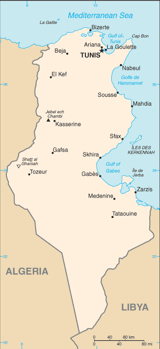
Be creative, use the extras of this Google map; This is a detailed, clear, zoomable, large road map of Tunisia with its administrative divisions; 24 governorates (wilayat, singular – wilayah); Beja (Bajah), Ben Arous (Bin ‘Arus), Bizerte (Banzart), Gabes (Qabis), Gafsa (Qafsah), Jendouba (Jundubah), Kairouan (Al Qayrawan), Kasserine (Al Qasrayn), Kebili (Qibili), Kef (Al Kaf), L’Ariana (Aryanah), Mahdia (Al Mahdiyah), Manouba (Manubah), Medenine (Madanin), Monastir (Al Munastir), Nabeul (Nabul), Sfax (Safaqis), Sidi Bouzid (Sidi Bu Zayd), Siliana (Silyanah), Sousse (Susah), Tataouine (Tatawin), Tozeur (Tawzar), Tunis, Zaghouan (Zaghwan).
The interactive map above is also may be used as the satellite map of Tunisia, or as a reverse search map for finding an address from its GPS coordinates.
Tunisia, at the northernmost bulge of Africa, thrusts out toward Sicily to mark the division between the eastern and western Mediterranean Sea. Twice the size of South Carolina, it is bordered on the west by Algeria and by Libya on the south. Coastal plains on the east rise to a north-south escarpment that slopes gently to the west. The Sahara Desert lies in the southernmost part. Tunisia is more mountainous in the north, where the Atlas range continues from Algeria.
Tunisia (area: 163 610 sq km / 63 170,15 sq mi), where the official language is Arabic, lying in Africa and using the currency; Tunisian dinar (TND), since 1958, set their clock to UTC+1. That means they are 6 hours ahead of Washington DC during Standard Time in Tunis, the capital. Note to the time difference: N/A.
The climate in Tunisia; Summer temperatures are high. The north is often wet and windy in winter. Far south is arid.
Geography in a nutshell; Mountains in the north are surrounded by plains. Vast, low-lying salt pans in the center. To the south lies the Sahara Desert.
Click here for more detailed information about Tunisia.
Driving directions Tunisia
The Google maps and Google Satellite maps of Tunisia above showing the country, located next to Algeria, Libya. For your further reference, the latitude and longitude coordinates of Tunisia are 34 00 N, 9 00 E , while the capital, Tunis found at 36 48 N 10 11 E.
When you are traveling around Tunisia, Tunis, or its other cities, use this routing tool, providing up to date route planning service free of charge.
Look no further; get accurate driving directions in Tunisia, Africa, by filling the route planner form below.
Since Google acquired and introduced its digitalized maps in 2004, you’re probably familiar with its base functions, like finding an address or driving directions to locations. Still, Google maps also accommodate bicyclists, pedestrians, and also public transportation with special directions and customizable routes.
About Tunisia and the capital, Tunis
 |
 |
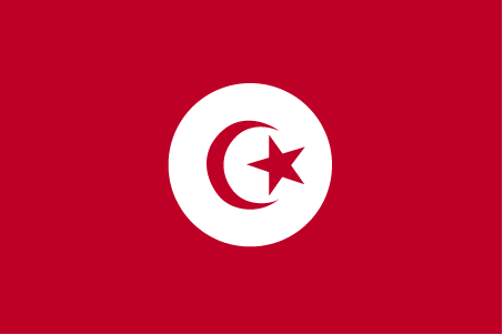
| The national flag of Tunisia | Borderline map of Tunisia |
| Flag description: red with a white disk in the center bearing a red crescent nearly encircling a red five-pointed star; resembles the Ottoman flag (red banner with white crescent and star) and recalls Tunisia’s history as part of the Ottoman Empire; red represents the bloodshed by martyrs in the struggle against oppression, white stands for peace; the crescent and star are traditional symbols of Islam. Note: the flag is based on that of Turkey, itself a successor state to the Ottoman Empire. | Border length: total: 1,495 km. Border countries (total: 2): Algeria 1,034 km, Libya 461 km. |
Did you know about Tunisia?
- Part of the Turkish Empire until 1881,Tunisia then became a French Protectorate. In 1957, it became a republic when the “Bey” was deposed.
- Tunisia was the center of trading empires from the 9th century BCE.
- Popular with Europeans, Tunisia is an alluring destination on the Mediterranean coast for hot beach vacations.
Facts of Tunisia (TN)
Name conventional long form: Republic of Tunisia, conventional short form: Tunisia, local long form: Al Jumhuriyah at Tunisiyah, local short form: Tunis. Note: the country name derives from the capital city of Tunis
Codes: ISO; TN, Internet; .tn
Capital city: Tunis
Language(s): Arabic (official language, one of the languages of commerce), French (commerce), Berber (Tamazight). Note: despite having no official language status, French plays a major role in the country and is spoken by about two-thirds of the population
National holiday(s): Independence Day, 20 March (1956); Revolution and Youth Day, 14 January (2011)
Motto: Horiya, nizam, adala (Liberty, Justice, Order)
Currency: Tunisian dinar (TND), since 1958
GPS: 34 00 N, 9 00 E, Tunis; 36 48 N 10 11 E
Location: Northern Africa, bordering the Mediterranean Sea, between Algeria and Libya
Geography note: strategic location in central Mediterranean; Malta and Tunisia are discussing the commercial exploitation of the continental shelf between their countries, particularly for oil exploration
Land boundaries: Algeria 1,034 km, Libya 461 km, total: 1,495 km
Maritime boundaries: N/A
Coastline: 1,148 km
Area: total: 163,610 sq km; land: 155,360 sq km, water: 8,250 sq km (total 63 170,15 mi2), slightly larger than Georgia.
Roadways: total: 19,418 km, paved: 14,756 km (includes 357 km of expressways), unpaved: 4,662 km (2010)
Waterways: N/A
Local time (capital): UTC+1, 6 hours ahead of Washington DC during Standard Time
Note to the local time: N/A
Population in Tunisia: 11 659 174
Population in Tunis: 790 000 (including the metropolitan areas)
Urbanization: urban population: 66.8% of total population (2015)
Major urban areas population: TUNIS (capital) 1.993 million (2015)
Population growth rate: 0.86% (2016 estimate)
Birth rate: 16.4 births / 1,000 population (2016 estimate)
Death rate: 6 deaths / 1,000 population (2016 estimate)
Age structure: 0-14 years: 23.02% (male 1,320,426 / female 1,243,287) 15-24 years: 15.05% (male 840,907 / female 834,320) 25-54 years: 44.52% (male 2,402,272 / female 2,554,362) 55-64 years: 9.21% (male 520,305 / female 505,612) 65 years and over: 8.2% (male 448,870 / female 464,227) (2016 estimate)
Median age: total: 32.4 years; male: 31.9 years, female: 32.7 years (2016 estimate)
Ethnic groups: Arab 98%, European 1%, Jewish and other 1%
Religions: Muslim (official; Sunni) 99.1%, other (includes Christian, Jewish, Shia Muslim, and Baha’i) 1%
Government type: Unitary semi-presidential republic
Legal system: mixed legal system of civil law, based on the French civil code, and Islamic law; some judicial review of legislative acts in the Supreme Court in joint session
National anthem: Humat Al-Hima (Defenders of the Homeland)
Known national hazards: N/A
Major infectious diseases: N/A
Land use: agricultural land: 64.8%; arable land 18.3%; permanent crops 15.4%; permanent pasture 31.1%; forest: 6.6%; other: 28.6% (2011 estimate)
Agricultural products: olives, olive oil, grain, tomatoes, citrus fruit, sugar beets, dates, almonds; beef, dairy products
Industries: petroleum, mining (particularly phosphate, iron ore), tourism, textiles, footwear, agribusiness, beverages
Export commodities: clothing, semi-finished goods and textiles, agricultural products, mechanical goods, phosphates and chemicals, hydrocarbons, electrical equipment
Main export partners: France 28.5%, Italy 17.2%, Germany 10.9%, Libya 6.1%, Spain 4.2% (2015)
Import commodities: textiles, machinery and equipment, hydrocarbons, chemicals, foodstuffs
Main import partners: France 19.4%, Italy 16.4%, Algeria 8.2%, Germany 7.4%, China 6% (2015)
Navigate the countries in Africa faster and easier while driving, use the interactive Google maps for your driving directions. The continuously updated database contains over 220 countries and territories digitally mapped, hundreds of millions of businesses and places around the world positioned on the map.
Get fresh GPS navigation, traffic, and transit information – no matter what part of Tunisia, Tunis, any other city and country in Africa, or the world you’re in.
Do you like this Tunisia information page? Please don’t forget to share it with others! Thank you.