Sao Tome and Principe Google maps and Driving Directions
Get free driving directions, Google maps, traffic information for Sao Tome and Principe, and Sáo Tomé (GPS: 0 20 N 6 44 E), the capital city of the country located in (the) Central Africa, islands in the Gulf of Guinea, just north of the Equator, west of Gabon.
Find any address in Sáo Tomé on the Google map of Sao Tome and Principe (ST) with ease or calculate your up to date itinerary to and from Sao Tome and Principe or its neighboring counties like N/A.
Sightseeing and exploring in Africa starts here, thanks to Google because its Earth Engine combines a multi-petabyte catalog of updated satellite imagery and geospatial datasets with planetary-scale analysis capabilities. Wonder the world, use the satellite map function of the Google maps to explore or see differences on the Earth’s surface, inland, or the surrounding areas of Sao Tome and Principe.
Google Maps Sao Tome and Principe
A former Portuguese colony, Sáo Tomé and Príncipe comprises two main islands and surrounding islets, off the west coast of Africa. Elections in 1991 ended 15 years of Marxism.
Sao Tome and Principe is volcanic, mountainous.
The map above fully covers Sao Tome and Principe with its road routes from cities to towns, road intersections in any region, provinces, prefectures, also with free driving directions in Sáo Tomé or to the neighboring towns and countries. To look at the detailed map about a particular quarter in Sao Tome, please click on the area and zoom to the place you are interested in the Google maps of Sao Tome and Principe (ST).
Be creative, use the extras of this Google map; This is a detailed, clear, zoomable, large road map of Sao Tome and Principe with its administrative divisions; 2 provinces; Principe, Sao Tome.
The interactive map above is also may be used as the satellite map of Sao Tome and Principe, or as a reverse search map for finding an address from its GPS coordinates.
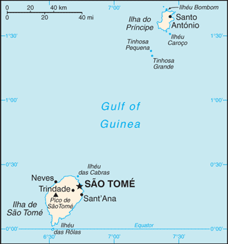
The tiny volcanic islands of Sáo Tomé and Príncipe lie in the Gulf of Guinea about 150 mi (240 km) off West Africa. Sáo Tomé (about 330 sq mi 859 sq km) is covered by a dense mountainous jungle, out of which have been carved large plantations. Príncipe (about 40 sq mi 142 sq km) consists of jagged mountains. Other islands in the republic are Pedras Tinhosas and Rolas. About 95% of the population lives on Sáo Tomé.
Sáo Tomé and Príncipe (area: 964 sq km / 372,2 sq mi), where the official language is Portuguese, lying in Africa and using the currency; Sáo Tomé and Príncipe dobra (STD), since 1977, set their clock to UTC 0. That means they are 5 hours ahead of Washington DC during Standard Time in Sao Tome, the capital. Note to the time difference: N/A.
The climate in Sao Tome and Principe; Hot and humid, but cooled by the Benguela Current. Plentiful rainfall.
Geography in a nutshell; Islands scattered across the equator. Sáo Tomé and Príncipe are heavily forested and mountainous.
Click here for more detailed information about Sao Tome and Principe.
Driving directions Sao Tome and Principe
The Google maps and Google Satellite maps of Sao Tome and Principe above showing the country, located next to N/A. For your further reference, the latitude and longitude coordinates of Sao Tome and Principe are 1 00 N, 7 00 E , while the capital, Sao Tome found at 0 20 N 6 44 E.
When you are traveling around Sao Tome and Principe, Sao Tome, or its other cities, use this routing tool, providing up to date route planning service free of charge.
Look no further; get accurate driving directions in Sao Tome and Principe, Africa, by filling the route planner form below.
Since Google acquired and introduced its digitalized maps in 2004, you’re probably familiar with its base functions, like finding an address or driving directions to locations. Still, Google maps also accommodate bicyclists, pedestrians, and also public transportation with special directions and customizable routes.
About Sao Tome and Principe and the capital, Sáo Tomé
 |
 |
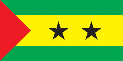
| The national flag of Sao Tome and Principe | Borderline map of Sao Tome and Principe |
| Flag description: three horizontal bands of green (top), yellow (double width), and green with two black five-pointed stars placed side by side in the center of the yellow band and a red isosceles triangle based on the hoist side; green stands for the country’s rich vegetation, red recalls the struggle for independence, and yellow represents cocoa, one of the country’s main agricultural products; the two stars symbolize the two main islands. Note: uses the popular Pan-African colors of Ethiopia. | Border length: 0 km. |
Did you know about Sao Tome and Principe?
- Sáo Tomé & Príncipe are a pair of islands in the Gulf of Guinea that formerly belonged to Portugal. They became independent in 1975.
- Cocoa provides 95% of export earnings. Coconuts, pepper, coffee also farmed. Tourism potential. Offshore oil may come onstream in 2012.
- Largely volcanic, this two-island republic depends on cocoa exports for almost all its income.
Facts of Sao Tome and Principe (ST)
Name conventional long form: Democratic Republic of Sao Tome and Principe, conventional short form: Sao Tome and Principe, local long form: Republica Democratica de Sao Tome e Principe, local short form: Sao Tome e Principe, etymology: Sao Tome was named after Saint THOMAS the Apostle by the Portuguese who discovered the island on 21 December 1470 (or 1471), the saint’s feast day; Principe is a shortening of the original Portuguese name of “Ilha do Principe” (Isle of the Prince) referring to the Prince of Portugal to whom duties on the island’s sugar crop were paid
Codes: ISO; ST, Internet; .st
Capital city: Sáo Tomé
Language(s): Portuguese 98.4% (official language), Forro 36.2%, Cabo Verdian 8.5%, French 6.8%, Angolar 6.6%, English 4.9%, Lunguie 1%, other (including sign language) 2.4%. Note: shares sum to more than 100% because some respondents gave more than one answer on the census (2012 estimate)
National holiday(s): Independence Day, 12 July (1975)
Motto: Unidade, Disciplina, Trabalho (Unity, Discipline, Work)
Currency: Sáo Tomé and Príncipe dobra (STD), since 1977
GPS: 1 00 N, 7 00 E, Sáo Tomé; 0 20 N 6 44 E
Location: Central Africa, islands in the Gulf of Guinea, just north of the Equator, west of Gabon
Geography note: the smallest country in Africa; the two main islands form part of a chain of extinct volcanoes and both are mountainous
Land boundaries: N/A, 0 km
Maritime boundaries: Atlantic Ocean
Coastline: 209 km
Area: total: 964 sq km; land: 964 sq km, water: 0 sq km (total 372,2 mi2), more than five times the size of Washington, DC.
Roadways: total: 320 km, paved: 218 km, unpaved: 102 km (2000)
Waterways: N/A
Local time (capital): UTC 0, 5 hours ahead of Washington DC during Standard Time
Note to the local time: N/A
Population in Sao Tome and Principe: 208 818
Population in Sao Tome: 64 000 (including the metropolitan areas)
Urbanization: urban population: 65.1% of total population (2015)
Major urban areas population: SAO TOME (capital) 71,000 (2014)
Population growth rate: 1.78% (2016 estimate)
Birth rate: 33.3 births / 1,000 population (2016 estimate)
Death rate: 7 deaths / 1,000 population (2016 estimate)
Age structure: 0-14 years: 42.47% (male 42,660 / female 41,234) 15-24 years: 20.33% (male 20,358 / female 19,808) 25-54 years: 30.66% (male 29,728 / female 30,829) 55-64 years: 3.7% (male 3,342 / female 3,959) 65 years and over: 2.85% (male 2,506 / female 3,117) (2016 estimate)
Median age: total: 18.2 years; male: 17.8 years, female: 18.6 years (2016 estimate)
Ethnic groups: mestico, angolares (descendants of Angolan slaves), forros (descendants of freed slaves), servicais (contract laborers from Angola, Mozambique, and Cape Verde), tongas (children of servicais born on the islands), Europeans (primarily Portuguese), Asians (mostly Chinese)
Religions: Catholic 55.7%, Adventist 4.1%, Assembly of God 3.4%, New Apostolic 2.9%, Mana 2.3%, Universal Kingdom of God 2%, Jehovah’s Witness 1.2%, other 6.2%, none 21.2%, unspecified 1% (2012 estimate)
Government type: Unitary semi-presidential republic
Legal system: mixed legal system of civil law base on the Portuguese model and customary law
National anthem: Independencia (Total Independence)
Known national hazards: N/A
Major infectious diseases: The degree of risk(s): high food or waterborne diseases: bacterial diarrhea, hepatitis A, and typhoid fever vectorborne diseases: malaria and dengue feverwater contact disease: schistosomiasis (2016)
Land use: agricultural land: 50.7%; arable land 9.1%; permanent crops 40.6%; permanent pasture 1%; forest: 28.1%; other: 21.2% (2011 estimate)
Agricultural products: cocoa, coconuts, palm kernels, copra, cinnamon, pepper, coffee, bananas, papayas, beans; poultry; fish
Industries: light construction, textiles, soap, beer, fish processing, timber
Export commodities: cocoa 80%, copra, coffee, palm oil (2010 estimate)
Main export partners: Netherlands 29.2%, Belgium 22.4%, Spain 15.5%, US 6.6%, Nigeria 5.1% (2015)
Import commodities: machinery and electrical equipment, food products, petroleum products
Main import partners: Portugal 65.2%, China 8.1%, Gabon 7.3% (2015)
Navigate the countries in Africa faster and easier while driving, use the interactive Google maps for your driving directions. The continuously updated database contains over 220 countries and territories digitally mapped, hundreds of millions of businesses and places around the world positioned on the map.
Get fresh GPS navigation, traffic, and transit information – no matter what part of Sao Tome and Principe, Sáo Tomé, any other city and country in Africa, or the world you’re in.
Do you like this Sao Tome and Principe information page? Please don’t forget to share it with others! Thank you.