Cape Verde Google maps and Driving Directions
Get free driving directions, Google maps, traffic information for Cape Verde, and Praia (GPS: 14 55 N 23 31 W), the capital city of the country located in (the) Western Africa, group of islands in the North Atlantic Ocean, west of Senegal.
Find any address in Praia on the Google map of Cape Verde (CV) with ease or calculate your up to date itinerary to and from Cape Verde or its neighboring counties like N/A.
Sightseeing and exploring in Africa starts here, thanks to Google because its Earth Engine combines a multi-petabyte catalog of updated satellite imagery and geospatial datasets with planetary-scale analysis capabilities. Wonder the world, use the satellite map function of the Google maps to explore or see differences on the Earth’s surface, inland, or the surrounding areas of Cape Verde.
Google Maps Cape Verde
Off the west coast of Africa, in the Atlantic Ocean, lies the group of islands that make up Cape Verde, a Portuguese colony until it gained independence in 1975.
Cape Verde is steep, rugged, rocky, volcanic.
The map above fully covers Cape Verde with its road routes from cities to towns, road intersections in any region, provinces, prefectures, also with free driving directions in Praia or to the neighboring towns and countries. To look at the detailed map about a particular quarter in Praia, please click on the area and zoom to the place you are interested in the Google maps of Cape Verde (CV).
Be creative, use the extras of this Google map; This is a detailed, clear, zoomable, large road map of Cape Verde with its administrative divisions; 22 municipalities (concelhos, singular – concelho); Boa Vista, Brava, Maio, Mosteiros, Paul, Porto Novo, Praia, Ribeira Brava, Ribeira Grande, Ribeira Grande de Santiago, Sal, Santa Catarina, Santa Catarina do Fogo, Santa Cruz, Sao Domingos, Sao Filipe, Sao Lourenco dos Orgaos, Sao Miguel, Sao Salvador do Mundo, Sao Vicente, Tarrafal, Tarrafal de Sao Nicolau.
The interactive map above is also may be used as the satellite map of Cape Verde, or as a reverse search map for finding an address from its GPS coordinates.
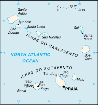
Cape Verde, only slightly larger than Rhode Island, is an archipelago in the Atlantic 385 mi (500 km) west of Senegal. The islands are divided into two groups: Barlavento in the north, composed of Santo Antao (291 sq mi 754 sq km), Boa Vista (240 sq mi 622 sq km), Sáo Nicolau (132 sq mi 342 sq km), Sáo Vicente (88 sq mi 246 sq km), Sal (83 sq mi 298 sq km), and Santa Luzia (13 sq mi 34 sq km) and Sotavento in the south, consisting of Sáo Tiago (383 sq mi 992 sq km), Fogo (184 sq mi 477 sq km), Maio (103 sq mi 267 sq km), and Brava (25 sq mi 65 sq km). The islands are mostly mountainous, with the land deeply scarred by erosion. There is an active volcano on Fogo.
Cape Verde (area: 4 033 sq km / 1 557,15 sq mi), where the official language is Portuguese, lying in Africa and using the currency; Cape Verdean escudo (CVE), since 1975, set their clock to UTC-1. That means they are 4 hours ahead of Washington DC during Standard Time in Praia, the capital. Note to the time difference: N/A.
The climate in Cape Verde; Warm, and very dry. Subject to droughts that can sometimes last for years at a time.
Geography in a nutshell; Ten main islands and eight smaller islets, all of volcanic origin. Mostly mountainous, with steep cliffs and rocky headlands.
Click here for more detailed information about Cape Verde.
Driving directions Cape Verde
The Google maps and Google Satellite maps of Cape Verde above showing the country, located next to N/A. For your further reference, the latitude and longitude coordinates of Cape Verde are 16 00 N, 24 00 W , while the capital, Praia found at 14 55 N 23 31 W.
When you are traveling around Cape Verde, Praia, or its other cities, use this routing tool, providing up to date route planning service free of charge.
Look no further; get accurate driving directions in Cape Verde, Africa, by filling the route planner form below.
Since Google acquired and introduced its digitalized maps in 2004, you’re probably familiar with its base functions, like finding an address or driving directions to locations. Still, Google maps also accommodate bicyclists, pedestrians, and also public transportation with special directions and customizable routes.
About Cape Verde and the capital, Praia
 |
 |
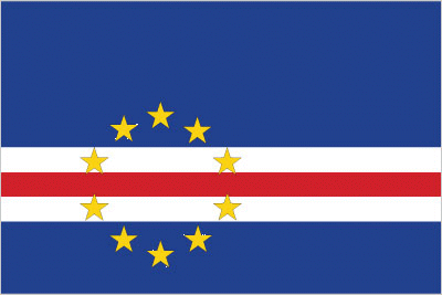
| The national flag of Cape Verde | Borderline map of Cape Verde |
| Flag description: five unequal horizontal bands; the top-most band of blue – equal to one half the width of the flag – is followed by three bands of white, red, and white, each equal to 1/12 of the width, and a bottom stripe of blue equal to one quarter of the flag width; a circle of 10, yellow, five-pointed stars is centered on the red stripe and positioned 3/8 of the length of the flag from the hoist side; blue stands for the sea and the sky, the circle of stars represents the 10 major islands united into a nation, the stripes symbolize the road to formation of the country through peace (white) and effort (red). | Border length: 0 km. |
Did you know about Cape Verde?
- Cape Verde was originally an overseas province of Portugal. It obtained independence in 1975. In 1992, a multiparty constitution adopted.
- Poor soils and lack of surface water mean that Cape Verde is dependent on food aid.
- Before the arrival of Europeans, the Cape Verde Islands were uninhabited.
Facts of Cape Verde (CV)
Name conventional long form: Republic of Cabo Verde, conventional short form: Cabo Verde, local long form: Republica de Cabo Verde, local short form: Cabo Verde, etymology: the name derives from Cap-Vert (Green Cape) on the Senegalese coast, the westernmost point of Africa and the nearest mainland to the islands
Codes: ISO; CV, Internet; .cv
Capital city: Praia
Language(s): Portuguese (official language), Crioulo (a blend of Portuguese and West African words)
National holiday(s): Independence Day, 5 July (1975)
Motto: Unidade, Trabalho, Progresso
Currency: Cape Verdean escudo (CVE), since 1975
GPS: 16 00 N, 24 00 W, Praia; 14 55 N 23 31 W
Location: Western Africa, group of islands in the North Atlantic Ocean, west of Senegal
Geography note: strategic location 500 km from west coast of Africa near major north-south sea routes; important communications station; important sea and air refueling site
Land boundaries: N/A, 0 km
Maritime boundaries: Atlantic Ocean
Coastline: 965 km
Area: total: 4,033 sq km; land: 4,033 sq km, water: 0 sq km (total 1 557,15 mi2), slightly larger than Rhode Island.
Roadways: total: 1,350 km, paved: 932 km, unpaved: 418 km (2013)
Waterways: N/A
Local time (capital): UTC-1, 4 hours ahead of Washington DC during Standard Time
Note to the local time: N/A
Population in Cape Verde: 553 335
Population in Praia: 99 400 (including the metropolitan areas)
Urbanization: urban population: 65.5% of total population (2015)
Major urban areas population: PRAIA (capital) 145,000 (2014)
Population growth rate: 1.35% (2016 estimate)
Birth rate: 20.2 births / 1,000 population (2016 estimate)
Death rate: 6.1 deaths / 1,000 population (2016 estimate)
Age structure: 0-14 years: 29.6% (male 82,359 / female 81,448) 15-24 years: 20.56% (male 56,885 / female 56,882) 25-54 years: 39.2% (male 105,383 / female 111,535) 55-64 years: 5.53% (male 13,131 / female 17,479) 65 years and over: 5.12% (male 10,722 / female 17,608) (2016 estimate)
Median age: total: 24.9 years; male: 24.1 years, female: 25.7 years (2016 estimate)
Ethnic groups: Creole (mulatto) 71%, African 28%, European 1%
Religions: Roman Catholic 77.3%, Protestant 4.6% (includes Church of the Nazarene 1.7%, Adventist 1.5%, Assembly of God 0.9%, Universal Kingdom of God 0.4%, and God and Love 0.1%), other Christian 3.4% (includes Christian Rationalism 1.9%, Jehovah’s Witness 1%, and New Apostolic 0.5%), Muslim 1.8%, other 1.3%, none 10.8%, unspecified 0.7% (2010 estimate)
Government type: Unitary semi-presidential republic
Legal system: civil law system of Portugal
National anthem: Cântico da Liberdade
Known national hazards: prolonged droughts; seasonal harmattan wind produces obscuring dust; volcanically and seismically activevolcanism: Fogo (elev. 2,829 m), which last erupted in 1995, is Cape Verde’s only active volcano
Major infectious diseases: note: active local transmission of Zika virus by Aedes species mosquitoes has been identified in this country (as of August 2016); it poses an important risk (a large number of cases possible) among US citizens if bitten by an infective mosquito; other less common ways to get Zika are through sex, via blood transfusion, or during pregnancy, in which the pregnant woman passes Zika virus to her fetus (2016)
Land use: agricultural land: 18.6%; arable land 11.7%; permanent crops 0.7%; permanent pasture 6.2%; forest: 21%; other: 60.4% (2011 estimate)
Agricultural products: bananas, corn, beans, sweet potatoes, sugarcane, coffee, peanuts; fish
Industries: food and beverages, fish processing, shoes and garments, salt mining, ship repair
Export commodities: fuel (re-exports), shoes, garments, fish, hides
Main export partners: Australia 83%, Spain 8.6% (2015)
Import commodities: foodstuffs, industrial products, transport equipment, fuels
Main import partners: Portugal 29.9%, Australia 26.4%, Netherlands 11.2%, Spain 5.6%, China 5.6% (2015)
Navigate the countries in Africa faster and easier while driving, use the interactive Google maps for your driving directions. The continuously updated database contains over 220 countries and territories digitally mapped, hundreds of millions of businesses and places around the world positioned on the map.
Get fresh GPS navigation, traffic, and transit information – no matter what part of Cape Verde, Praia, any other city and country in Africa, or the world you’re in.
Do you like this Cape Verde information page? Please don’t forget to share it with others! Thank you.