Austria Google maps and Driving Directions
Get free driving directions, Google maps, traffic information for Austria, and Vienna (GPS: 48 12 N 16 22 E), the capital city of the country located in (the) Central Europe, north of Italy and Slovenia.
Find any address in Vienna on the Google map of Austria (AT) with ease or calculate your up to date itinerary to and from Austria or its neighboring counties like Czech Republic, Germany, Hungary, Italy, Liechtenstein, Slovakia, Slovenia, Switzerland.
Sightseeing and exploring in Europe starts here, thanks to Google because its Earth Engine combines a multi-petabyte catalog of updated satellite imagery and geospatial datasets with planetary-scale analysis capabilities. Wonder the world, use the satellite map function of the Google maps to explore or see differences on the Earth’s surface, inland, or the surrounding areas of Austria.
Google Maps Austria
Bordering eight countries in the heart of Europe, Austria was created in 1918 after the collapse of the Habsburg Empire. Neutral after World War II, it joined the EU in 1995.
Austria is mostly mountains (Alps) in the west and south; mostly flat or gently sloping along the eastern and northern margins.
The map above fully covers Austria with its road routes from cities to towns, road intersections in any region, provinces, prefectures, also with free driving directions in Vienna or to the neighboring towns and countries. To look at the detailed map about a particular quarter in Vienna, please click on the area and zoom to the place you are interested in the Google maps of Austria (AT).
Be creative, use the extras of this Google map; This is a detailed, clear, zoomable, large road map of Austria with its administrative divisions; 9 states (Bundeslaender, singular – Bundesland); Burgenland, Kaernten (Carinthia), Niederoesterreich (Lower Austria), Oberoesterreich (Upper Austria), Salzburg, Steiermark (Styria), Tirol (Tyrol), Vorarlberg, Wien (Vienna).
The interactive map above is also may be used as the satellite map of Austria, or as a reverse search map for finding an address from its GPS coordinates.
Slightly smaller than Maine, Austria includes much of the mountainous territory of the eastern Alps (about 75% of the area). The country contains many snowfields, glaciers, and snowcapped peaks, the highest being the Grossglockner (12,530 ft 3,819 m). The Danube is the principal river. Forests and woodlands cover about 40% of the land.
Austria (area: 83 871 sq km / 32 382,76 sq mi), where the official language is German, lying in Europe and using the currency; Euro (EUR), since 1999, set their clock to UTC+1. That means they are 6 hours ahead of Washington DC during Standard Time in Vienna, the capital. Note to the time difference: Daylight saving time: +1hr begins last Sunday in March; ends last Sunday in October.
The climate in Austria; Temperate continental climate. The western Alpine regions have colder winters and more rainfall.
Geography in a nutshell; Mainly mountainous. Alps and foothills cover the west and south. Lowlands in the east are part of the Danube River basin.
Click here for more detailed information about Austria.
Driving directions Austria
The Google maps and Google Satellite maps of Austria above showing the country, located next to Czech Republic, Germany, Hungary, Italy, Liechtenstein, Slovakia, Slovenia, Switzerland. For your further reference, the latitude and longitude coordinates of Austria are 47 20 N, 13 20 E , while the capital, Vienna found at 48 12 N 16 22 E.
When you are traveling around Austria, Vienna, or its other cities, use this routing tool, providing up to date route planning service free of charge.
Look no further; get accurate driving directions in Austria, Europe, by filling the route planner form below.
Since Google acquired and introduced its digitalized maps in 2004, you’re probably familiar with its base functions, like finding an address or driving directions to locations. Still, Google maps also accommodate bicyclists, pedestrians, and also public transportation with special directions and customizable routes.
About Austria and the capital, Vienna
 |
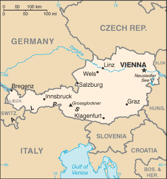 |
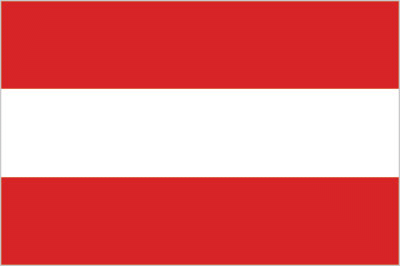
| The national flag of Austria | Borderline map of Austria |
| Flag description: three equal horizontal bands of red (top), white, and red; the flag design is certainly one of the oldest – if not the oldest – national banners in the world; according to tradition, in 1191, following a fierce battle in the Third Crusade, Duke Leopold V of Austria’s white tunic became completely blood-spattered; upon removal of his wide belt or sash, a white band was revealed; the red-white-red color combination was subsequently adopted as his banner. | Border length: total: 2,524 km. Border countries (total: 8): Czech Republic 402 km, Germany 801 km, Hungary 321 km, Italy 404 km, Liechtenstein 34 km, Slovakia 105 km, Slovenia 299 km, Switzerland 158 km. |
About Vienna
Vienna still retains much of the glory and grandeur of the empire’s heady days. Museum treasures from all over Europe, baroque palaces through which Maria Theresa and her brood wandered, Johann Strauss’s lively music, Gustav Klimt’s paintings, the concert halls, the unparalleled opera – it’s all still here as if the empire were still flourishing. Tourism is growing as thousands arrive every year to view Vienna’s great art and architecture, to feast on lavish Viennese pastries, to explore the Vienna Woods, to sail down the Danube, to attend Vienna’s balls, operas, and festivals, and to listen to the “music that never stops.”
Visitors today face a newer and brighter Vienna, a city with more joie de vivre and punch than it’s had since before the war. There’s also a downside: Prices are on the rise – they haven’t reached the height of the Ferris wheel at the Prater, but they’re climbing there.
Did you know about Austria?
- Austria once ruled much of central Europe, but lost most of its territory in 1919. Between 1938 and 1945 Austria was annexed to Germany.
- Many of the worlds great composers were Austrian, including Mozart, Haydn, Schubert, and Strauss.
- The birthplace of Mozart and the Strauss family, Austria is famous for its music, as well as its delectable Sacher Torte chocolate cake.
Austria is a landlocked Alpine country with most of its territory situated within the eastern Alps. Some lower-lying land does occur, however, in the basin of the River Danube and along the country’s eastern border south of Vienna, the country’s capital. About 61 percent of Austrians live in cities or urban areas.
Over a third of Austria is forested, providing the country with valuable timber resources. Hydroelectric power schemes supply about two-thirds of the country’s electricity needs, with some exported. Austria has modest reserves of iron ore, lignite, oil, natural gas, lead, zinc, copper, magnesium, salt, gypsum, talc, and kaolin and although there is only a limited amount of land available for agriculture, the country is able to produce enough food to meet most of its own domestic needs.
Austria is a prosperous country with a fairly wide manufacturing base. The Alpine scenery, picturesque and historic villages and towns, music festivals and sporting opportunities make Austria a popular holiday destination and tourism makes a significant contribution to the economy.
Facts of Austria (AT)
Name conventional long form: Republic of Austria, conventional short form: Austria, local long form: Republik Oesterreich, local short form: Oesterreich, etymology: the name Oesterreich means “eastern realm” or “eastern march” and dates to the 10th century; the designation refers to the fact that Austria was the easternmost extension of Bavaria, and in fact of all the Germans; the word Austria is a Latinization of the German name
Codes: ISO; AT, Internet; .at
Capital city: Vienna
Language(s): German (official language nationwide) 88.6%, Turkish 2.3%, Serbian 2.2%, Croatian (official language in Burgenland) 1.6%, other (includes Slovene, official language in South Carinthia, and Hungarian, official language in Burgenland) 5.3% (2001 estimate)
National holiday(s): National Day, 26 October (1955)
Motto: N/A
Currency: Euro (EUR), since 1999
GPS: 47 20 N, 13 20 E, Vienna; 48 12 N 16 22 E
Location: Central Europe, north of Italy and Slovenia
Geography note: landlocked country; strategic location at the crossroads of central Europe with many easily traversable Alpine passes and valleys; major river is the Danube; population is concentrated on eastern lowlands because of steep slopes, poor soils, and low temperatures elsewhere
Land boundaries: Czech Republic 402 km, Germany 801 km, Hungary 321 km, Italy 404 km, Liechtenstein 34 km, Slovakia 105 km, Slovenia 299 km, Switzerland 158 km, total: 2,524 km
Maritime boundaries: N/A
Coastline: 0 km (landlocked country)
Area: total: 83,871 sq km; land: 82,445 sq km, water: 1,426 sq km (total 32 382,76 mi2), about the size of South Carolina; slightly more than two-thirds the size of Pennsylvania.
Roadways: total: 133,597 km, paved: 133,597 km (includes 2,207 km of expressways) (2016)
Waterways: 358 km (2011)
Local time (capital): UTC+1, 6 hours ahead of Washington DC during Standard Time
Note to the local time: Daylight saving time: +1hr begins last Sunday in March; ends last Sunday in October
Population in Austria: 8 751 820
Population in Vienna: 2 041 300 (including the metropolitan areas)
Urbanization: urban population: 66% of total population (2015)
Major urban areas population: VIENNA (capital) 1.753 million (2015)
Population growth rate: 0.51% (2016 estimate)
Birth rate: 9.5 births / 1,000 population (2016 estimate)
Death rate: 9.5 deaths / 1,000 population (2016 estimate)
Age structure: 0-14 years: 14.02% (male 625,391 / female 596,310) 15-24 years: 11.33% (male 503,333 / female 483,748) 25-54 years: 42.71% (male 1,859,985 / female 1,860,641) 55-64 years: 12.85% (male 554,191 / female 565,189) 65 years and over: 19.09% (male 719,012 / female 943,970) (2016 estimate)
Median age: total: 43.8 years; male: 42.7 years, female: 44.9 years (2016 estimate)
Ethnic groups: Austrians 91.1%, former Yugoslavs 4% (includes Croatians, Slovenes, Serbs, and Bosniaks), Turks 1.6%, Germans 0.9%, other or unspecified 2.4% (2001 census)
Religions: Catholic 73.8% (includes Roman Catholic 73.6%, other Catholic 0.2%), Protestant 4.9%, Muslim 4.2%, Orthodox 2.2%, other 0.8% (includes other Christian), none 12%, unspecified 2% (2001 estimate)
Government type: Federal parliamentary republic
Legal system: civil law system; judicial review of legislative acts by the Constitutional Court
National anthem: Land der Berge, Land am Strome (Land of Mountains, Land by the River)
Known national hazards: landslides; avalanches; earthquakes
Major infectious diseases: N/A
Land use: agricultural land: 38.4%; arable land 16.5%; permanent crops 0.8%; permanent pasture 21.1%; forest: 47.2%; other: 14.4% (2011 estimate)
Agricultural products: grains, potatoes, wine, fruit; dairy products, cattle, pigs, poultry; lumber and other forestry products
Industries: construction, machinery, vehicles and parts, food, metals, chemicals, lumber, paper and paperboard, communications equipment, tourism
Export commodities: machinery and equipment, motor vehicles and parts, paper and paperboard, metal goods, chemicals, iron and steel, textiles, foodstuffs
Main export partners: Germany 29.4%, US 6.4%, Italy 6.1%, Switzerland 5.7%, France 4.4%, Slovakia 4.2% (2015)
Import commodities: machinery and equipment, motor vehicles, chemicals, metal goods, oil and oil products, natural gas; foodstuffs
Main import partners: Germany 41.5%, Italy 6.3%, Switzerland 6%, Czech Republic 4.2% (2015)
Navigate the countries in Europe faster and easier while driving, use the interactive Google maps for your driving directions. The continuously updated database contains over 220 countries and territories digitally mapped, hundreds of millions of businesses and places around the world positioned on the map.
Get fresh GPS navigation, traffic, and transit information – no matter what part of Austria, Vienna, any other city and country in Europe, or the world you’re in.
Do you like this Austria information page? Please don’t forget to share it with others! Thank you.