Czechia Google maps and Driving Directions
Get free driving directions, Google maps, traffic information for Czechia, and Prague (GPS: 50 05 N 14 28 E), the capital city of the country located in (the) Central Europe, between Germany, Poland, Slovakia, and Austria.
Find any address in Prague on the Google map of Czechia (CZ) with ease or calculate your up to date itinerary to and from Czechia or its neighboring counties like Austria, Germany, Poland, Slovakia.
Sightseeing and exploring in Europe starts here, thanks to Google because its Earth Engine combines a multi-petabyte catalog of updated satellite imagery and geospatial datasets with planetary-scale analysis capabilities. Wonder the world, use the satellite map function of the Google maps to explore or see differences on the Earth’s surface, inland, or the surrounding areas of Czechia.
Google Maps Czechia
Once part of Czechoslovakia, a central European communist state in 19481989, the Czech Republic peacefully dissolved its union with Slovakia in 1993. It joined the EU in 2004.
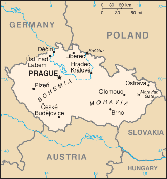
Czechia is Bohemia in the west consists of rolling plains, hills, and plateaus surrounded by low mountains; Moravia in the east consists of very hilly country.
The map above fully covers Czechia with its road routes from cities to towns, road intersections in any region, provinces, prefectures, also with free driving directions in Prague or to the neighboring towns and countries. To look at the detailed map about a particular quarter in Prague, please click on the area and zoom to the place you are interested in the Google maps of Czechia (CZ).
Be creative, use the extras of this Google map; This is a detailed, clear, zoomable, large road map of Czechia with its administrative divisions; 13 regions (kraje, singular – kraj) and 1 capital city* (hlavni mesto); Jihocesky (South Bohemia), Jihomoravsky (South Moravia), Karlovarsky (Karlovy Vary), Kralovehradecky (Hradec Kralove), Liberecky (Liberec), Moravskoslezsky (Moravia-Silesia), Olomoucky (Olomouc), Pardubicky (Pardubice), Plzensky (Pilsen), Praha (Prague)*, Stredocesky (Central Bohemia), Ustecky (Usti), Vysocina (Highlands), Zlinsky (Zlin).
The interactive map above is also may be used as the satellite map of Czechia, or as a reverse search map for finding an address from its GPS coordinates.
The Czech Republic’s central European landscape is dominated by the Bohemian Massif, which rises to heights of 3,000 ft (900 m) above sea level. This ring of mountains encircles a large elevated basin, the Bohemian Plateau. The principal rivers are the Elbe and the Vltava.
Czech Republic (area: 78 865 sq km / 30 449,93 sq mi), where the official language is Czech, lying in Europe and using the currency; Czech koruna (CZK), since 1993, set their clock to UTC+1. That means they are 6 hours ahead of Washington DC during Standard Time in Prague, the capital. Note to the time difference: Daylight saving time: +1hr begins last Sunday in March; ends last Sunday in October.
The climate in Czechia; Cool, sometimes cold winters and warm summer months, which bring most of the annual rainfall.
Geography in a nutshell; Landlocked in central Europe. Bohemia, the western territory, is a plateau surrounded by mountains. Moravia, in the east, is characterized by hills and lowlands.
Click here for more detailed information about Czechia.
Driving directions Czechia
The Google maps and Google Satellite maps of Czechia above showing the country, located next to Austria, Germany, Poland, Slovakia. For your further reference, the latitude and longitude coordinates of Czechia are 49 45 N, 15 30 E , while the capital, Prague found at 50 05 N 14 28 E.
When you are traveling around Czechia, Prague, or its other cities, use this routing tool, providing up to date route planning service free of charge.
Look no further; get accurate driving directions in Czechia, Europe, by filling the route planner form below.
Since Google acquired and introduced its digitalized maps in 2004, you’re probably familiar with its base functions, like finding an address or driving directions to locations. Still, Google maps also accommodate bicyclists, pedestrians, and also public transportation with special directions and customizable routes.
About Czechia and the capital, Prague
 |
 |
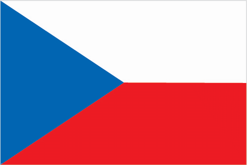
| The national flag of Czechia | Borderline map of Czechia |
| Flag description: two equal horizontal bands of white (top) and red with a blue isosceles triangle based on the hoist side. Note: is identical to the flag of the former Czechoslovakia. | Border length: total: 2,143 km. Border countries (total: 4): Austria 402 km, Germany 704 km, Poland 796 km, Slovakia 241 km. |
About Prague
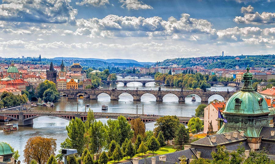
Prague has stood the test of time, but the floods of 2002 threatened to ruin centuries of culture and history forever. Happily, the waters were no match for the robust landmarks and iron will of the people of this ancient kingdom, and the city is back, and better than ever. Here, the last 1,000 years of triumphs in art and architecture have collided, often violently, with power politics and religious conflicts.
While Prague’s rich collection of Gothic, baroque, and Renaissance buildings has stood stoically through all the strife, the streets and squares fronting the grand halls have often been the stages for tragedy. The well-worn cobblestones have felt the hooves of kings’ horses, the jackboots of Hitler’s armies, the heaving wheels of Soviet tanks, and the shuffling feet of students in passive revolt. Today spaghetti-strand alleys winding through Old Town are jammed with armies of visitors jostling for space to experience an aura of “Golden Prague” only to be bombarded with peddlers. But while Prague’s rebirth and its embrace of capitalism have come with labor pains of inflation, traffic jams (with new Western cars), and the ever-present pounding of construction crews, the stately spires of this living baroque and medieval museum rise above it all.
Despite the furious development and reconstruction popping up all over, the classical monuments remain the city’s bedrock. Prague Castle’s reflection in the Vltava or the mellow nighttime glow of the lanterns around the 18th-century Stavovské Divadlo (Estates Theater) gives the city a Mozart-really-was-here feel.
Did you know about Czechia?
- The Czech Republic was part of Austria until 1919, when it merged with Slovakia to form Czechoslovakia. The states separated in 1993.
- Charles University in Prague was founded in the 13th century.
- Prague, the Czech capital, is one of Europes most beautiful capital cities, sitting on the River Vltava and dominated by its historic castle.
The Czech Republic was created in 1993 when it separated from Slovakia, the two having formerly united as Czechoslovakia. It is a landlocked country that shares borders with Austria, Germany, Poland, and Slovakia. The country is almost ringed by mountains that stretch over the borders with neighboring countries.
Lying east of the center of the country, the Moravian Highlands give way to lower-lying, rolling plains. There are numerous rivers in the country and several freshwater lakes. Forests, including the Bohemian Forest, cover about a third of the Czech Republic. The republic’s capital is the beautiful, ancient city of Prague (Praha) located on the bank of the Vltava river. More than two-thirds of Czechs live in cities or towns.
The lower-lying areas and river valleys provide suitable farming land, and the country has valuable timber resources, particularly in the Bohemian Forest. Lignite is the most abundant mineral resource, but there are also some reserves of hard coal, uranium, tin, antimony and mercury, iron ore, lead, and zinc. The country relies heavily on imported oil and gas and coal-fired power stations to generate electricity. Mining and heavy industries have declined in recent years although iron and steel, machinery and vehicle production are still significant. Traditional craft products include beautiful crystal from Bohemia, decorated glass and painted eggs.
Facts of Czechia (CZ)
Name conventional long form: Czech Republic, conventional short form: Czechia, local long form: Ceska republika, local short form: Cesko, etymology: name derives from the Czechs, a West Slavic tribe who rose to prominence in the late 9th century A.D.
Codes: ISO; CZ, Internet; .cz
Capital city: Prague
Language(s): Czech (official language) 95.4%, Slovak 1.6%, other 3% (2011 census)
National holiday(s): Czechoslovak Founding Day, 28 October (1918)
Motto: Pravda vítezí
Currency: Czech koruna (CZK), since 1993
GPS: 49 45 N, 15 30 E, Prague; 50 05 N 14 28 E
Location: Central Europe, between Germany, Poland, Slovakia, and Austria
Geography note: landlocked country; strategically located astride some of oldest and most significant land routes in Europe; Moravian Gate is a traditional military corridor between the North European Plain and the Danube in central Europe
Land boundaries: Austria 402 km, Germany 704 km, Poland 796 km, Slovakia 241 km, total: 2,143 km
Maritime boundaries: N/A
Coastline: 0 km (landlocked country)
Area: total: 78,867 sq km; land: 77,247 sq km, water: 1,620 sq km (total 30 449,93 mi2), slightly smaller than South Carolina.
Roadways: total: 130,661 km (includes urban roads)paved: 130,661 km (includes 730 km of expressways) (2011)
Waterways: 664 km (principally on Elbe, Vltava, Oder, and other navigable rivers, lakes, and canals) (2010)
Local time (capital): UTC+1, 6 hours ahead of Washington DC during Standard Time
Note to the local time: Daylight saving time: +1hr begins last Sunday in March; ends last Sunday in October
Population in Czechia: 10 625 250
Population in Prague: 1 378 700 (including the metropolitan areas)
Urbanization: urban population: 73% of total population (2015)
Major urban areas population: PRAGUE (capital) 1.314 million (2015)
Population growth rate: 0.14% (2016 estimate)
Birth rate: 9.5 births / 1,000 population (2016 estimate)
Death rate: 10.4 deaths / 1,000 population (2016 estimate)
Age structure: 0-14 years: 15.09% (male 826,005 / female 782,470) 15-24 years: 9.89% (male 542,433 / female 511,941) 25-54 years: 43.79% (male 2,396,550 / female 2,271,974) 55-64 years: 12.73% (male 658,784 / female 698,782) 65 years and over: 18.5% (male 817,550 / female 1,154,443) (2016 estimate)
Median age: total: 41.7 years; male: 40.4 years, female: 43 years (2016 estimate)
Ethnic groups: Czech 64.3%, Moravian 5%, Slovak 1.4%, other 1.8%, unspecified 27.5% (2011 estimate)
Religions: Roman Catholic 10.4%, Protestant (includes Czech Brethren and Hussite) 1.1%, other and unspecified 54%, none 34.5% (2011 estimate)
Government type: Unitary parliamentary constitutional republic
Legal system: new civil code enacted in 2014, replacing civil code of 1964 – based on former Austro-Hungarian civil codes and socialist theory – and reintroducing former Czech legal terminology
National anthem: Kde domov muj (Where is my home)
Known national hazards: flooding
Major infectious diseases: N/A
Land use: agricultural land: 54.8%; arable land 41%; permanent crops 1%; permanent pasture 12.8%; forest: 34.4%; other: 10.8% (2011 estimate)
Agricultural products: wheat, potatoes, sugar beets, hops, fruit; pigs, poultry
Industries: motor vehicles, metallurgy, machinery and equipment, glass, armaments
Export commodities: machinery and transport equipment, raw materials, fuel, chemicals
Main export partners: Germany 32.4%, Slovakia 9%, Poland 5.8%, UK 5.3%, France 5.1%, Austria 4.1% (2015)
Import commodities: machinery and transport equipment, raw materials and fuels, chemicals
Main import partners: Germany 30%, Poland 9%, China 8.3%, Slovakia 6.6%, Netherlands 5%, Austria 4.1% (2015)
Navigate the countries in Europe faster and easier while driving, use the interactive Google maps for your driving directions. The continuously updated database contains over 220 countries and territories digitally mapped, hundreds of millions of businesses and places around the world positioned on the map.
Get fresh GPS navigation, traffic, and transit information – no matter what part of Czechia, Prague, any other city and country in Europe, or the world you’re in.
Do you like this Czechia information page? Please don’t forget to share it with others! Thank you.