Central African Republic Google maps and Driving Directions
Get free driving directions, Google maps, traffic information for Central African Republic, and Bangui (GPS: 4 22 N 18 35 E), the capital city of the country located in (the) Central Africa, north of Democratic Republic of the Congo.
Find any address in Bangui on the Google map of Central African Republic (CF) with ease or calculate your up to date itinerary to and from Central African Republic or its neighboring counties like Cameroon, Chad, Democratic Republic of Congo, Republic of the Congo, South Sudan, Sudan.
Sightseeing and exploring in Africa starts here, thanks to Google because its Earth Engine combines a multi-petabyte catalog of updated satellite imagery and geospatial datasets with planetary-scale analysis capabilities. Wonder the world, use the satellite map function of the Google maps to explore or see differences on the Earth’s surface, inland, or the surrounding areas of Central African Republic.
Google Maps Central African Republic
The Central African Republic (CAR) is a landlocked country lying between the basins of the Chad and Congo Rivers. Politics has suffered frequent interruption by military coups.
Central African Republic is vast, flat to rolling plateau; scattered hills in northeast and southwest.
The map above fully covers Central African Republic with its road routes from cities to towns, road intersections in any region, provinces, prefectures, also with free driving directions in Bangui or to the neighboring towns and countries. To look at the detailed map about a particular quarter in Bangui, please click on the area and zoom to the place you are interested in the Google maps of Central African Republic (CF).
Be creative, use the extras of this Google map; This is a detailed, clear, zoomable, large road map of Central African Republic with its administrative divisions; 14 prefectures (prefectures, singular – prefecture), 2 economic prefectures* (prefectures economiques, singular – prefecture economique), and 1 commune**; Bamingui-Bangoran, Bangui**, Basse-Kotto, Haute-Kotto, Haut-Mbomou, Kemo, Lobaye, Mambere-Kadei, Mbomou, Nana-Grebizi*, Nana-Mambere, Ombella-Mpoko, Ouaka, Ouham, Ouham-Pende, Sangha-Mbaere*, Vakaga.
The interactive map above is also may be used as the satellite map of Central African Republic, or as a reverse search map for finding an address from its GPS coordinates.
Situated about 500 mi (805 km) north of the equator, the Central African Republic is a landlocked nation bordered by Cameroon, Chad, the Sudan, the Democratic Republic of the Congo, and the Republic of Congo. The Ubangi and the Shari are the largest of many rivers.
Central African Republic (area: 622 984 sq km / 240 535,37 sq mi), where the official language is French, Sango, lying in Africa and using the currency; Central African CFA franc (XAF), set their clock to UTC+1. That means they are 6 hours ahead of Washington DC during Standard Time in Bangui, the capital. Note to the time difference: N/A.
The climate in Central African Republic; The south is equatorial; the north is hot and dry. Rain occurs all year round, with heaviest falls between July and October.
Geography in a nutshell; Comprises a low plateau, covered by scrub or savanna. North is arid. Equatorial rainforests in the south. The Ubangi River forms the border with the Democratic Republic of the Congo.
Click here for more detailed information about Central African Republic.
Driving directions Central African Republic
The Google maps and Google Satellite maps of Central African Republic above showing the country, located next to Cameroon, Chad, Democratic Republic of Congo, Republic of the Congo, South Sudan, Sudan. For your further reference, the latitude and longitude coordinates of Central African Republic are 7 00 N, 21 00 E , while the capital, Bangui found at 4 22 N 18 35 E.
When you are traveling around Central African Republic, Bangui, or its other cities, use this routing tool, providing up to date route planning service free of charge.
Look no further; get accurate driving directions in Central African Republic, Africa, by filling the route planner form below.
Since Google acquired and introduced its digitalized maps in 2004, you’re probably familiar with its base functions, like finding an address or driving directions to locations. Still, Google maps also accommodate bicyclists, pedestrians, and also public transportation with special directions and customizable routes.
About Central African Republic and the capital, Bangui
 |
 |
| The national flag of Central African Republic | Borderline map of Central African Republic |
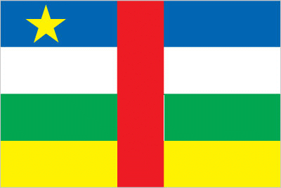
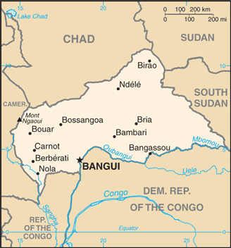
| Flag description: four equal horizontal bands of blue (top), white, green, and yellow with a vertical red band in center; a yellow five-pointed star to the hoist side of the blue band; banner combines the Pan-African and French flag colors; red symbolizes the blood spilled in the struggle for independence, blue represents the sky and freedom, white peace and dignity, green hope and faith, and yellow tolerance; the star represents aspiration towards a vibrant future. | Border length: total: 5,920 km. Border countries (total: 6): Cameroon 901 km, Chad 1,556 km, Democratic Republic of the Congo 1,747 km, Republic of the Congo 487 km, South Sudan 1,055 km, Sudan 174 km. |
Did you know about Central African Republic?
- Previously known as Ubangui-Shari, the Central African Republic was formed as an autonomous state in 1958 under French protection.
- “Emperor” Bokassas eccentric rule from 1965 to 1979 was followed by military dictatorship until democracy was restored in 1993.
- Landlocked with few roads and no railways, the Central African Republic largely relies on the Ubangi River as its main transportation link, which flows along the southern border of the country to join the Congo River.
Facts of Central African Republic (CF)
Name conventional long form: Central African Republic, conventional short form: none, local long form: Republique Centrafricaine, local short form: none, former: Ubangi-Shari, Central African Empireabbreviation: CAR, etymology: self-descriptive name specifying the country’s location on the continent; “Africa” is derived from the Roman designation of the area corresponding to present-day Tunisia “Africa terra,” which meant “Land of the Afri” (the tribe resident in that area), but which eventually came to mean the entire continent
Codes: ISO; CF, Internet; .cf
Capital city: Bangui
Language(s): French (official language), Sangho (lingua franca and national language), tribal languages
National holiday(s): Republic Day, 1 December (1958)
Motto: Unité, Dignité, Travail (Unity, Dignity, Work)
Currency: Central African CFA franc (XAF)
GPS: 7 00 N, 21 00 E, Bangui; 4 22 N 18 35 E
Location: Central Africa, north of Democratic Republic of the Congo
Geography note: landlocked country; almost the precise center of Africa
Land boundaries: Cameroon 901 km, Chad 1,556 km, Democratic Republic of the Congo 1,747 km, Republic of the Congo 487 km, South Sudan 1,055 km, Sudan 174 km, total: 5,920 km
Maritime boundaries: N/A
Coastline: 0 km (landlocked country)
Area: total: 622,984 sq km; land: 622,984 sq km, water: 0 sq km (total 240 535,37 mi2), slightly smaller than Texas.
Roadways: total: 20,278 km, paved: 1,385 km, unpaved: 18,893 km (2010)
Waterways: 2,800 km (the primary navigable river is the Ubangi, which joins the River Congo; it was the traditional route for the export of products because it connected with the Congo-Ocean railway at Brazzaville; because of the warfare on both sides of the River Congo from 1997, importers and exporters preferred routes through Cameroon) (2011)
Local time (capital): UTC+1, 6 hours ahead of Washington DC during Standard Time
Note to the local time: N/A
Population in Central African Republic: 4 737 423
Population in Bangui: 810 000 (including the metropolitan areas)
Urbanization: urban population: 40% of total population (2015)
Major urban areas population: BANGUI (capital) 794,000 (2015)
Population growth rate: 2.12% (2016 estimate)
Birth rate: 34.7 births / 1,000 population (2016 estimate)
Death rate: 13.5 deaths / 1,000 population (2016 estimate)
Age structure: 0-14 years: 40.27% (male 1,114,727 / female 1,102,809) 15-24 years: 19.98% (male 553,264 / female 547,308) 25-54 years: 32.24% (male 888,304 / female 887,348) 55-64 years: 4.04% (male 101,306 / female 120,964) 65 years and over: 3.47% (male 74,516 / female 116,711) (2016 estimate)
Median age: total: 19.6 years; male: 19.3 years, female: 19.9 years (2016 estimate)
Ethnic groups: Baya 33%, Banda 27%, Mandjia 13%, Sara 10%, Mboum 7%, M’Baka 4%, Yakoma 4%, other 2%
Religions: indigenous beliefs 35%, Protestant 25%, Roman Catholic 25%, Muslim 15%note: animistic beliefs and practices strongly influence the Christian majority
Government type: Semi-presidential republic
Legal system: civil law system based on the French model
National anthem: La Renaissance (The Renaissance)
Known national hazards: hot, dry, dusty harmattan winds affect northern areas; floods are common
Major infectious diseases: The The degree of risk(s): very high food or waterborne diseases: bacterial and protozoal diarrhea, hepatitis A and E, and typhoid fever vectorborne diseases: malaria and dengue feverrespiratory disease: meningococcal meningitiswater contact disease: schistosomiasis animal contact disease: rabies (2016)
Land use: agricultural land: 8.1%; arable land 2.9%; permanent crops 0.1%; permanent pasture 5.1%; forest: 36.2%; other: 55.7% (2011 estimate)
Agricultural products: cotton, coffee, tobacco, cassava (manioc, tapioca), yams, millet, corn, bananas; timber
Industries: gold and diamond mining, logging, brewing, sugar refining
Export commodities: diamonds, timber, cotton, coffee
Main export partners: Norway 52.2%, China 14.1%, Democratic Republic of the Congo 8.3% (2015)
Import commodities: food, textiles, petroleum products, machinery, electrical equipment, motor vehicles, chemicals, pharmaceuticals
Main import partners: Norway 39.6%, France 6.8%, US 4.6% (2015)
Navigate the countries in Africa faster and easier while driving, use the interactive Google maps for your driving directions. The continuously updated database contains over 220 countries and territories digitally mapped, hundreds of millions of businesses and places around the world positioned on the map.
Get fresh GPS navigation, traffic, and transit information – no matter what part of Central African Republic, Bangui, any other city and country in Africa, or the world you’re in.
Do you like this Central African Republic information page? Please don’t forget to share it with others! Thank you.