Burundi Google maps and Driving Directions
Get free driving directions, Google maps, traffic information for Burundi, and Bujumbura (GPS: 3 22 S 29 21 E), the capital city of the country located in (the) Central Africa, east of the Democratic Republic of the Congo, west of Tanzania.
Find any address in Bujumbura on the Google map of Burundi (BY) with ease or calculate your up to date itinerary to and from Burundi or its neighboring counties like Democratic Republic of Congo, Rwanda, Tanzania.
Sightseeing and exploring in Africa starts here, thanks to Google because its Earth Engine combines a multi-petabyte catalog of updated satellite imagery and geospatial datasets with planetary-scale analysis capabilities. Wonder the world, use the satellite map function of the Google maps to explore or see differences on the Earth’s surface, inland, or the surrounding areas of Burundi.
Google Maps Burundi
Small, densely populated and landlocked, Burundi lies just south of the equator, on the NileCongo watershed in central Africa. Its people have the worlds lowest per capita income.
Burundi is hilly and mountainous, dropping to a plateau in east, some plains.
The map above fully covers Burundi with its road routes from cities to towns, road intersections in any region, provinces, prefectures, also with free driving directions in Bujumbura or to the neighboring towns and countries. To look at the detailed map about a particular quarter in Bujumbura, please click on the area and zoom to the place you are interested in the Google maps of Burundi (BY).
Be creative, use the extras of this Google map; This is a detailed, clear, zoomable, large road map of Burundi with its administrative divisions; 18 provinces; Bubanza, Bujumbura Mairie, Bujumbura Rural, Bururi, Cankuzo, Cibitoke, Gitega, Karuzi, Kayanza, Kirundo, Makamba, Muramvya, Muyinga, Mwaro, Ngozi, Rumonge, Rutana, Ruyigi.
The interactive map above is also may be used as the satellite map of Burundi, or as a reverse search map for finding an address from its GPS coordinates.
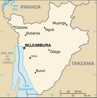
Wedged between Tanzania, the Democratic Republic of the Congo, and Rwanda in east-central Africa, Burundi occupies a high plateau divided by several deep valleys. It is equal in size to Maryland.
Burundi (area: 27 834 sq km / 10 746,76 sq mi), where the official language is French, Kirundi, lying in Africa and using the currency; Burundian franc (BIF), since 1960, set their clock to UTC+2. That means they are 7 hours ahead of Washington DC during Standard Time in Bujumbura, the capital. Note to the time difference: N/A.
The climate in Burundi; Temperate, with high humidity. Heavy and frequent rainfall, mostly October May. Highlands have frost.
Geography in a nutshell; Hilly with high plateaus in center and savanna in the east. Great Rift Valley on western side.
Click here for more detailed information about Burundi.
Driving directions Burundi
The Google maps and Google Satellite maps of Burundi above showing the country, located next to Democratic Republic of Congo, Rwanda, Tanzania. For your further reference, the latitude and longitude coordinates of Burundi are 3 30 S, 30 00 E , while the capital, Bujumbura found at 3 22 S 29 21 E.
When you are traveling around Burundi, Bujumbura, or its other cities, use this routing tool, providing up to date route planning service free of charge.
Look no further; get accurate driving directions in Burundi, Africa, by filling the route planner form below.
Since Google acquired and introduced its digitalized maps in 2004, you’re probably familiar with its base functions, like finding an address or driving directions to locations. Still, Google maps also accommodate bicyclists, pedestrians, and also public transportation with special directions and customizable routes.
About Burundi and the capital, Bujumbura
 |
 |
| The national flag of Burundi | Borderline map of Burundi |
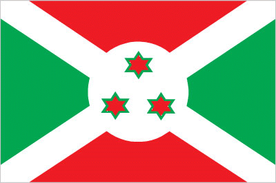
| Flag description: divided by a white diagonal cross into red panels (top and bottom) and green panels (hoist side and fly side) with a white disk superimposed at the center bearing three red six-pointed stars outlined in green arranged in a triangular design (one star above, two stars below); green symbolizes hope and optimism, white purity and peace, and red the bloodshed in the struggle for independence; the three stars in the disk represent the three major ethnic groups: Hutu, Twa, Tutsi, as well as the three elements in the national motto: unity, work, progress. | Border length: total: 1,140 km. Border countries (total: 3): Democratic Republic of the Congo 236 km, Rwanda 315 km, Tanzania 589 km. |
Did you know about Burundi?
- Like Rwanda, Burundi was a German, then a Belgian territory. It achieved independence as a kingdom in 1962 and became a republic in 1966.
- Burundis fertility rate is one of the highest in Africa. On average, women have seven children.
- Fertile land is scarce in Burundi, so most farmers work small plots of land that are just big enough to feed a family.
Facts of Burundi (BY)
Name conventional long form: Republic of Burundi, conventional short form: Burundi, local long form: Republique du Burundi/Republika y’u Burundi, local short form: Burundi, former: Urundi, etymology: name derived from the pre-colonial Kingdom of Burundi (17th-19th century)
Codes: ISO; BY, Internet; .bi
Capital city: Bujumbura
Language(s): Kirundi 29.7% (official language), Kirundi and other language 9.1%, French (official language) and French and other language 0.3%, Swahili and Swahili and other language 0.2% (along Lake Tanganyika and in the Bujumbura area), English and English and other language 0.06%, more than 2 languages 3.7%, unspecified 56.9% (2008 estimate)
National holiday(s): Independence Day, 1 July (1962)
Motto: Unité, Travail, Progrés
Currency: Burundian franc (BIF), since 1960
GPS: 3 30 S, 30 00 E, Bujumbura; 3 22 S 29 21 E
Location: Central Africa, east of the Democratic Republic of the Congo, west of Tanzania
Geography note: landlocked country; straddles crest of the Nile-Congo watershed; the Kagera, which drains into Lake Victoria, is the most remote headstream of the White Nile
Land boundaries: Democratic Republic of the Congo 236 km, Rwanda 315 km, Tanzania 589 km, total: 1,140 km
Maritime boundaries: N/A
Coastline: 0 km (landlocked country)
Area: total: 27,830 sq km; land: 25,680 sq km, water: 2,150 sq km (total 10 746,76 mi2), slightly smaller than Maryland.
Roadways: total: 12,322 km, paved: 1,286 km, unpaved: 11,036 km (2004)
Waterways: (mainly on Lake Tanganyika between Bujumbura, Burundi’s principal port, and lake ports in Tanzania, Zambia, and the Democratic Republic of the Congo) (2011)
Local time (capital): UTC+2, 7 hours ahead of Washington DC during Standard Time
Note to the local time: N/A
Population in Burundi: 11 216 450
Population in Bujumbura: 331 700 (including the metropolitan areas)
Urbanization: urban population: 12.1% of total population (2015)
Major urban areas population: BUJUMBURA (capital) 751,000 (2015)
Population growth rate: 3.26% (2016 estimate)
Birth rate: 41.7 births / 1,000 population (2016 estimate)
Death rate: 9 deaths / 1,000 population (2016 estimate)
Age structure: 0-14 years: 45.61% (male 2,545,895 / female 2,516,480) 15-24 years: 19.17% (male 1,061,538 / female 1,066,581) 25-54 years: 28.71% (male 1,589,506 / female 1,597,081) 55-64 years: 3.94% (male 205,538 / female 231,317) 65 years and over: 2.57% (male 121,935 / female 163,427) (2016 estimate)
Median age: total: 17 years; male: 16.8 years, female: 17.2 years (2016 estimate)
Ethnic groups: Hutu (Bantu) 85%, Tutsi (Hamitic) 14%, Twa (Pygmy) 1%, Europeans 3,000, South Asians 2,000
Religions: Catholic 62.1%, Protestant 23.9% (includes Adventist 2.3% and other Protestant 21.6%), Muslim 2.5%, other 3.6%, unspecified 7.9% (2008 estimate)
Government type: Presidential republic
Legal system: mixed legal system of Belgian civil law and customary law
National anthem: Burundi bwacu (Our Burundi)
Known national hazards: flooding; landslides; drought
Major infectious diseases: The The degree of risk(s): very high food or waterborne diseases: bacterial and protozoal diarrhea, hepatitis A, and typhoid fever vectorborne diseases: malaria and dengue feverwater contact disease: schistosomiasis animal contact disease: rabies (2016)
Land use: agricultural land: 73.3%; arable land 38.9%; permanent crops 15.6%; permanent pasture 18.8%; forest: 6.6%; other: 20.1% (2011 estimate)
Agricultural products: coffee, cotton, tea, corn, sorghum, sweet potatoes, bananas, cassava (manioc, tapioca); beef, milk, hides
Industries: light consumer goods (blankets, shoes, soap, beer); assembly of imported components; public works construction; food processing
Export commodities: coffee, tea, sugar, cotton, hides
Main export partners: Germany 12.3%, Pakistan 10.7%, Democratic Republic of the Congo 10.7%, Uganda 8.1%, Sweden 7.8%, US 7.1%, Belgium 6.3%, Rwanda 4.6%, France 4.4% (2015)
Import commodities: capital goods, petroleum products, foodstuffs
Main import partners: Kenya 15%, Saudi Arabia 14%, Belgium 9.9%, Tanzania 8.3%, Uganda 7.3%, China 7.1%, India 4.9%, France 4% (2015)
Navigate the countries in Africa faster and easier while driving, use the interactive Google maps for your driving directions. The continuously updated database contains over 220 countries and territories digitally mapped, hundreds of millions of businesses and places around the world positioned on the map.
Get fresh GPS navigation, traffic, and transit information – no matter what part of Burundi, Bujumbura, any other city and country in Africa, or the world you’re in.
Do you like this Burundi information page? Please don’t forget to share it with others! Thank you.