Cyprus Google maps and Driving Directions
Get free driving directions, Google maps, traffic information for Cyprus, and Nicosia (GPS: 35 10 N 33 22 E), the capital city of the country located in (the) Middle East, island in the Mediterranean Sea, south of Turkey; note – Cyprus views itself as part of Europe; geopolitically, it can be classified as falling within Europe, the Middle East, or both.
Find any address in Nicosia on the Google map of Cyprus (CY) with ease or calculate your up to date itinerary to and from Cyprus or its neighboring counties like N/A.
Sightseeing and exploring in Europe starts here, thanks to Google because its Earth Engine combines a multi-petabyte catalog of updated satellite imagery and geospatial datasets with planetary-scale analysis capabilities. Wonder the world, use the satellite map function of the Google maps to explore or see differences on the Earth’s surface, inland, or the surrounding areas of Cyprus.
Google Maps Cyprus
Cyprus lies south of Turkey in the eastern Mediterranean. Since 1974, it has been partitioned between the Turkish-occupied north and the Greek-Cypriot south.
Cyprus is central plain with mountains to north and south; scattered but significant plains along southern coast.
The map above fully covers Cyprus with its road routes from cities to towns, road intersections in any region, provinces, prefectures, also with free driving directions in Nicosia or to the neighboring towns and countries. To look at the detailed map about a particular quarter in Nicosia, please click on the area and zoom to the place you are interested in the Google maps of Cyprus (CY).
Be creative, use the extras of this Google map; This is a detailed, clear, zoomable, large road map of Cyprus with its administrative divisions; 6 districts; Ammochostos (Famagusta); (all but a small part located in the Turkish Cypriot community), Keryneia (Kyrenia; the only district located entirely in the Turkish Cypriot community), Larnaka (Larnaca; with a small part located in the Turkish Cypriot community), Lefkosia (Nicosia; a small part administered by Turkish Cypriots), Lemesos (Limassol), Pafos (Paphos); note – the 5 “districts” of the “TRNC” are Gazimagusa (Famagusta), Girne (Kyrenia), Guzelyurt (Morphou), Iskele (Trikomo), Lefkosia (Nicosia).
The interactive map above is also may be used as the satellite map of Cyprus, or as a reverse search map for finding an address from its GPS coordinates.
The third-largest island in the Mediterranean (one and one-half times the size of Delaware), Cyprus lies off the southern coast of Turkey and the western shore of Syria. The highest peak is Mount Olympus at 6,406 ft (1,953 m).
Cyprus (area: 9 251 sq km / 3 571,83 sq mi), where the official language is Greek, Turkish, lying in Europe and using the currency; Euro (EUR), since 2008, set their clock to UTC+2. That means they are 7 hours ahead of Washington DC during Standard Time in Nicosia, the capital. Note to the time difference: Daylight saving time: +1hr begins last Sunday in March; ends last Sunday in October.
The climate in Cyprus; Mediterranean. Summers are hot and dry. Winters are mild, with snow in the mountains.
Geography in a nutshell; Mountains in the center-west give way to a fertile plain in the east, flanked by hills to the northeast.
Click here for more detailed information about Cyprus.
Driving directions Cyprus
The Google maps and Google Satellite maps of Cyprus above showing the country, located next to N/A. For your further reference, the latitude and longitude coordinates of Cyprus are 35 00 N, 33 00 E , while the capital, Nicosia found at 35 10 N 33 22 E.
When you are traveling around Cyprus, Nicosia, or its other cities, use this routing tool, providing up to date route planning service free of charge.
Look no further; get accurate driving directions in Cyprus, Middle East, by filling the route planner form below.
Since Google acquired and introduced its digitalized maps in 2004, you’re probably familiar with its base functions, like finding an address or driving directions to locations. Still, Google maps also accommodate bicyclists, pedestrians, and also public transportation with special directions and customizable routes.
About Cyprus and the capital, Nicosia
 |
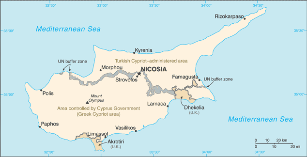 |
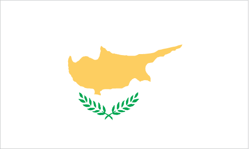
| The national flag of Cyprus | Borderline map of Cyprus |
| Flag description: white with a copper-colored silhouette of the island (the island has long been famous for its copper deposits) above two green crossed olive branches in the center of the flag; the branches symbolize the hope for peace and reconciliation between the Greek and Turkish communities. Note: the “Turkish Republic of Northern Cyprus” flag retains the white field of the Cyprus national flag but displays narrow horizontal red stripes positioned a small distance from the top and bottom edges between which are centered a red crescent and a red five-pointed star; the banner is modeled after the Turkish national flag but with the colors reversed. | Border length: total: 156 km. Border sovereign base areas: Akrotiri 48 km, Dhekelia 108 km. |
Did you know about Cyprus?
- In 1960, Cyprus gained independence after almost 100 years of British rule. In 1974, the island was partitioned, following an invasion by Turkey.
- The Green Line, which separates north from south, was opened for the first time in 2003.
- Aside from tourism, farming is the mainstay of Cypruss economy and Cypriots grow olives for their oil, citrus fruit, and grapes.
Facts of Cyprus (CY)
Name conventional long form: Republic of Cyprus, conventional short form: Cyprus, local long form: Kypriaki Dimokratia/Kibris Cumhuriyeti, local short form: Kypros/Kibris. Note: the Turkish Cypriot community, which administers the northern part of the island, refers to itself as the “Turkish Republic of Northern Cyprus” or “TRNC” (“Kuzey Kibris Turk Cumhuriyeti” or “KKTC”), etymology: the derivation of the name “Cyprus” is unknown, but the extensive mining of copper metal on the island in antiquity gave rise to the Latin word “cuprum” for copper
Codes: ISO; CY, Internet; .cy
Capital city: Nicosia
Language(s): Greek (official language) 80.9%, Turkish (official language) 0.2%, English 4.1%, Romanian 2.9%, Russian 2.5%, Bulgarian 2.2%, Arabic 1.2%, Filipino 1.1%, other 4.3%, unspecified 0.6%. Note: data represent only the government-controlled area of Cyprus (2011 estimate)
National holiday(s): Independence Day, 1 October (1960)
Motto: N/A
Currency: Euro (EUR), since 2008
GPS: 35 00 N, 33 00 E, Nicosia; 35 10 N 33 22 E
Location: Middle East, island in the Mediterranean Sea, south of Turkey; note – Cyprus views itself as part of Europe; geopolitically, it can be classified as falling within Europe, the Middle East, or both
Geography note: the third largest island in the Mediterranean Sea (after Sicily and Sardinia)
Land boundaries: Border sovereign base areas: Akrotiri 48 km, Dhekelia 108 km, total: 156 km
Maritime boundaries: Mediterranean Sea
Coastline: 648 km
Area: total: 9,251 sq km, land: 9,241 sq km, water: 10 sq km (total 3 571,83 mi2), about 0.6 times the size of Connecticut.
Roadways: total: 20,006 kmgovernment control: 13,006 km (includes 2,277 km of expressways), paved: 8,564 km, unpaved: 4,442 kmTurkish Cypriot control: 7,000 km (2011)
Waterways: N/A
Local time (capital): UTC+2, 7 hours ahead of Washington DC during Standard Time
Note to the local time: Daylight saving time: +1hr begins last Sunday in March; ends last Sunday in October
Population in Cyprus: 1 189 085
Population in Nicosia: 197 600 (including the metropolitan areas)
Urbanization: urban population: 66.9% of total population (2015)
Major urban areas population: NICOSIA (capital) 251,000 (2014)
Population growth rate: 1.38% (2016 estimate)
Birth rate: 11.4 births / 1,000 population (2016 estimate)
Death rate: 6.7 deaths / 1,000 population (2016 estimate)
Age structure: 0-14 years: 15.58% (male 96,582 / female 91,296) 15-24 years: 14.37% (male 94,262 / female 78,982) 25-54 years: 46.99% (male 298,368 / female 268,080) 55-64 years: 11.26% (male 65,005 / female 70,752) 65 years and over: 11.8% (male 61,581 / female 80,667) (2016 estimate)
Median age: total: 36.4 years; male: 35.1 years, female: 38 years (2016 estimate)
Ethnic groups: Greek 98.8%, other 1% (includes Maronite, Armenian, Turkish-Cypriot), unspecified 0.2%note: data represent only the government-controlled area of Cyprus (2011 estimate)
Religions: Orthodox Christian 89.1%, Roman Catholic 2.9%, Protestant/Anglican 2%, Muslim 1.8%, Buddhist 1%, other (includes Maronite, Armenian Church, Hindu) 1.4%, unknown 1.1%, none/atheist 0.6%note: data represent only the government-controlled area of Cyprus (2011 estimate)
Government type: Unitary presidential constitutional republic
Legal system: mixed legal system of English common law and civil law with European law supremacy
National anthem: Hymn to Liberty
Known national hazards: moderate earthquake activity; droughts
Major infectious diseases: N/A
Land use: agricultural land: 13.4%; arable land 9.8%; permanent crops 3.2%; permanent pasture 0.4%; forest: 18.8%; other: 67.8% (2011 estimate)
Agricultural products: citrus, vegetables, barley, grapes, olives, vegetables; poultry, pork, lamb; dairy, cheese
Industries: tourism, food and beverage processing, cement and gypsum, ship repair and refurbishment, textiles, light chemicals, metal products, wood, paper, stone and clay products
Export commodities: citrus, potatoes, pharmaceuticals, cement, clothing
Main export partners: Greece 10.9%, Ireland 10.2%, UK 7.2%, Israel 6% (2015)
Import commodities: consumer goods, petroleum and lubricants, machinery, transport equipment
Main import partners: Greece 25.7%, UK 9.1%, Italy 8%, Germany 7.5%, Israel 5.5%, China 4.8%, Netherlands 4.1% (2015)
Navigate the countries in Middle East faster and easier while driving, use the interactive Google maps for your driving directions. The continuously updated database contains over 220 countries and territories digitally mapped, hundreds of millions of businesses and places around the world positioned on the map.
Get fresh GPS navigation, traffic, and transit information – no matter what part of Cyprus, Nicosia, any other city and country in Europe, or the world you’re in.
Do you like this Cyprus information page? Please don’t forget to share it with others! Thank you.