Syria Google maps and Driving Directions
Get free driving directions, Google maps, traffic information for Syria, and Damascus (GPS: 33 30 N 36 18 E), the capital city of the country located in (the) Middle East, bordering the Mediterranean Sea, between Lebanon and Turkey.
Find any address in Damascus on the Google map of Syria (SY) with ease or calculate your up to date itinerary to and from Syria or its neighboring counties like Iraq, Israel, Jordan, Lebanon, Turkey.
Sightseeing and exploring in Asia starts here, thanks to Google because its Earth Engine combines a multi-petabyte catalog of updated satellite imagery and geospatial datasets with planetary-scale analysis capabilities. Wonder the world, use the satellite map function of the Google maps to explore or see differences on the Earth’s surface, inland, or the surrounding areas of Syria.
Google Maps Syria
Stretching from the eastern Mediterranean to the Tigris River, Syrias borders are regarded as an artificial creation of French colonial rule by many Syrians. Foreign relations are turbulent.
Syria is primarily semiarid and desert plateau; narrow coastal plain; mountains in west.
The map above fully covers Syria with its road routes from cities to towns, road intersections in any region, provinces, prefectures, also with free driving directions in Damascus or to the neighboring towns and countries. To look at the detailed map about a particular quarter in Damascus, please click on the area and zoom to the place you are interested in the Google maps of Syria (SY).
Be creative, use the extras of this Google map; This is a detailed, clear, zoomable, large road map of Syria with its administrative divisions; 14 provinces (muhafazat, singular – muhafazah); Al Hasakah, Al Ladhiqiyah (Latakia), Al Qunaytirah, Ar Raqqah, As Suwayda’, Dar’a, Dayr az Zawr, Dimashq (Damascus), Halab, Hamah, Hims (Homs), Idlib, Rif Dimashq (Damascus Countryside), Tartus.
The interactive map above is also may be used as the satellite map of Syria, or as a reverse search map for finding an address from its GPS coordinates.
Slightly larger than North Dakota, Syria lies at the eastern end of the Mediterranean Sea. It is bordered by Lebanon and Israel on the west, Turkey on the north, Iraq on the east, and Jordan on the south. Coastal Syria is a narrow plain, in back of which is a range of coastal mountains, and still farther inland a steppe area. In the east is the Syrian Desert and in the south is the Jebel Druze Range. The highest point in Syria is Mount Hermon (9,232 ft 2,814 m) on the Lebanese border.
Syria (area: 185 180 sq km / 71 498,37 sq mi), where the official language is Arabic, lying in Asia and using the currency; Syrian pound (SYP), set their clock to UTC+2. That means they are 7 hours ahead of Washington DC during Standard Time in Damascus, the capital. Note to the time difference: Daylight saving time: +1hr begins midnight on the last Friday in March; ends at midnight on the first Friday in November.
The climate in Syria; Mediterranean coastal climate. Inland areas are arid. In winter, snow is common on the mountains.
Geography in a nutshell; A short stretch of coastal plain is backed by a low range of hills. The Euphrates River cuts through a vast interior desert plateau.
Click here for more detailed information about Syria.
Driving directions Syria
The Google maps and Google Satellite maps of Syria above showing the country, located next to Iraq, Israel, Jordan, Lebanon, Turkey. For your further reference, the latitude and longitude coordinates of Syria are 35 00 N, 38 00 E , while the capital, Damascus found at 33 30 N 36 18 E.
When you are traveling around Syria, Damascus, or its other cities, use this routing tool, providing up to date route planning service free of charge.
Look no further; get accurate driving directions in Syria, Middle East, by filling the route planner form below.
Since Google acquired and introduced its digitalized maps in 2004, you’re probably familiar with its base functions, like finding an address or driving directions to locations. Still, Google maps also accommodate bicyclists, pedestrians, and also public transportation with special directions and customizable routes.
About Syria and the capital, Damascus
 |
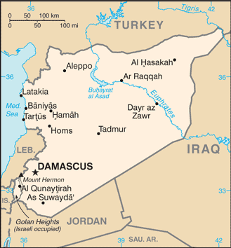 |
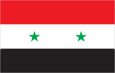
| The national flag of Syria | Borderline map of Syria |
| Flag description: three equal horizontal bands of red (top), white, and black; two small, green, five-pointed stars in a horizontal line centered in the white band; the band colors derive from the Arab Liberation flag and represent oppression (black), overcome through bloody struggle (red), to be replaced by a bright future (white); identical to the former flag of the United Arab Republic (1958-1961) where the two stars represented the constituent states of Syria and Egypt; the current design dates to 1980note: similar to the flag of Yemen, which has a plain white band, Iraq, which has an Arabic inscription centered in the white band, and that of Egypt, which has a gold Eagle of Saladin centered in the white band. | Border length: total: 2,363 km. Border countries (total: 5): Iraq 599 km, Israel 83 km, Jordan 379 km, Lebanon 403 km, Turkey 899 km. |
Did you know about Syria?
- Syria created after the dissolution of French colonial rule in 1946. From 19581961 it merged with Egypt to form the United Arab Republic.
- Syria is an ancient land; there are at least 3500 as yet unexcavated archaeological sites.
- Cotton is one of the main cash crops grown in Syria, alongside fruit and vegetables.
Facts of Syria (SY)
Name conventional long form: Syrian Arab Republic, conventional short form: Syria, local long form: Al Jumhuriyah al Arabiyah as Suriyah, local short form: Suriyah, former: United Arab Republic (with Egypt), etymology: name ultimately derived from the ancient Assyrians who dominated northern Mesopotamia, but whose reach also extended westward to the Levant; over time, the name came to be associated more with the western area
Codes: ISO; SY, Internet; .sy
Capital city: Damascus
Language(s): Arabic (official language), Kurdish, Armenian, Aramaic, Circassian, French, English
National holiday(s): Independence Day, 17 April (1946)
Motto: N/A
Currency: Syrian pound (SYP)
GPS: 35 00 N, 38 00 E, Damascus; 33 30 N 36 18 E
Location: Middle East, bordering the Mediterranean Sea, between Lebanon and Turkey
Geography note: the capital of Damascus – located at an oasis fed by the Barada River – is thought to be one of the world’s oldest continuously inhabited cities; there are 42 Israeli settlements and civilian land use sites in the Israeli-occupied Golan Heights (2014 estimate)
Land boundaries: Iraq 599 km, Israel 83 km, Jordan 379 km, Lebanon 403 km, Turkey 899 km, total: 2,363 km
Maritime boundaries: Mediterranean Sea
Coastline: 193 km
Area: total: 185,180 sq km; land: 183,630 sq km, water: 1,550 sq km (total 71 498,37 mi2), slightly more than 1.5 times the size of Pennsylvania.
Roadways: total: 69,873 km, paved: 63,060 km, unpaved: 6,813 km (2010)
Waterways: 900 km (navigable but not economically significant) (2011)
Local time (capital): UTC+2, 7 hours ahead of Washington DC during Standard Time
Note to the local time: Daylight saving time: +1hr begins midnight on the last Friday in March; ends at midnight on the first Friday in November
Population in Syria: 18 284 407
Population in Damascus: 2 650 000 (including the metropolitan areas)
Urbanization: urban population: 57.7% of total population (2015)
Major urban areas population: Aleppo 3.562 million; DAMASCUS (capital) 2.566 million; Hims (Homs) 1.641 million; Hamah 1.237 million; Lattakia 781,000 (2015)
Population growth rate: 1.56% (2016 estimate)
Birth rate: 21.7 births / 1,000 population (2016 estimate)
Death rate: 4 deaths / 1,000 population (2016 estimate)
Age structure: 0-14 years: 31.95% (male 2,815,140 / female 2,675,166) 15-24 years: 19.65% (male 1,711,847 / female 1,664,814) 25-54 years: 39.03% (male 3,342,264 / female 3,364,406) 55-64 years: 5.26% (male 447,205 / female 457,525) 65 years and over: 4.11% (male 318,691 / female 388,112) (2016 estimate)
Median age: total: 24.1 years; male: 23.7 years, female: 24.6 years (2016 estimate)
Ethnic groups: Arab 90.3%, Kurdish, Armenian, and other 9.7%
Religions: Muslim 87% (official; includes Sunni 74% and Alawi, Ismaili, and Shia 13%), Christian 10% (includes Orthodox, Uniate, and Nestorian), Druze 3%, Jewish (few remaining in Damascus and Aleppo)
Government type: Semi-presidential republic
Legal system: mixed legal system of civil and Islamic law (for family courts)
National anthem: Homat el Diyar (Guardians of the Homeland)
Known national hazards: dust storms, sandstormsvolcanism: Syria’s two historically active volcanoes, Es Safa and an unnamed volcano near the Turkish border have not erupted in centuries
Major infectious diseases: N/A
Land use: agricultural land: 75.8%; arable land 25.4%; permanent crops 5.8%; permanent pasture 44.6%; forest: 2.7%; other: 21.5% (2011 estimate)
Agricultural products: wheat, barley, cotton, lentils, chickpeas, olives, sugar beets; beef, mutton, eggs, poultry, milk
Industries: petroleum, textiles, food processing, beverages, tobacco, phosphate rock mining, cement, oil seeds crushing, automobile assembly
Export commodities: crude oil, minerals, petroleum products, fruits and vegetables, cotton fiber, textiles, clothing, meat and live animals, wheat
Main export partners: Iraq 64.7%, Saudi Arabia 11.2%, Kuwait 7.1%, UAE 6.1%, Libya 4.6% (2015)
Import commodities: machinery and transport equipment, electric power machinery, food and livestock, metal and metal products, chemicals and chemical products, plastics, yarn, paper
Main import partners: Saudi Arabia 28%, UAE 13.7%, Iran 10.1%, Turkey 9%, Iraq 8.3%, China 6.1% (2015)
Navigate the countries in Middle East faster and easier while driving, use the interactive Google maps for your driving directions. The continuously updated database contains over 220 countries and territories digitally mapped, hundreds of millions of businesses and places around the world positioned on the map.
Get fresh GPS navigation, traffic, and transit information – no matter what part of Syria, Damascus, any other city and country in Asia, or the world you’re in.
Do you like this Syria information page? Please don’t forget to share it with others! Thank you.