Jordan Google maps and Driving Directions
Get free driving directions, Google maps, traffic information for Jordan, and Amman (GPS: 31 57 N 35 56 E), the capital city of the country located in (the) Middle East, northwest of Saudi Arabia, between Israel (to the west) and Iraq.
Find any address in Amman on the Google map of Jordan (JO) with ease or calculate your up to date itinerary to and from Jordan or its neighboring counties like Iraq, Israel, Palestine, Saudi Arabia, Syria.
Sightseeing and exploring in Asia starts here, thanks to Google because its Earth Engine combines a multi-petabyte catalog of updated satellite imagery and geospatial datasets with planetary-scale analysis capabilities. Wonder the world, use the satellite map function of the Google maps to explore or see differences on the Earth’s surface, inland, or the surrounding areas of Jordan.
Google Maps Jordan
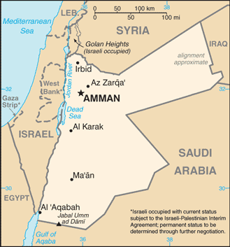
The Kingdom of Jordan lies east of Israel, and borders the Palestinian West Bank. Its relations with its Arab neighbors are troubled by its relatively close ties to the US.
Jordan is mostly desert plateau in east, highland area in west; Great Rift Valley separates eastern and western banks of the Jordan River.
The map above fully covers Jordan with its road routes from cities to towns, road intersections in any region, provinces, prefectures, also with free driving directions in Amman or to the neighboring towns and countries. To look at the detailed map about a particular quarter in Amman, please click on the area and zoom to the place you are interested in the Google maps of Jordan (JO).
Be creative, use the extras of this Google map; This is a detailed, clear, zoomable, large road map of Jordan with its administrative divisions; 12 governorates (muhafazat, singular – muhafazah); ‘Ajlun, Al ‘Aqabah, Al Balqa’, Al Karak, Al Mafraq, Al’Asimah, At Tafilah, Az Zarqa’, Irbid, Jarash, Ma’an, Ma’daba.
The interactive map above is also may be used as the satellite map of Jordan, or as a reverse search map for finding an address from its GPS coordinates.
The Middle East kingdom of Jordan is bordered on the west by Israel and the Dead Sea, on the north by Syria, on the east by Iraq, and on the south by Saudi Arabia. It is comparable in size to Indiana. Arid hills and mountains make up most of the country. The southern section of the Jordan River flows through the country.
Jordan (area: 89 342 sq km / 34 495,12 sq mi), where the official language is Arabic, lying in Asia and using the currency; Jordanian dinar (JOD), set their clock to UTC+2. That means they are 7 hours ahead of Washington DC during Standard Time in Amman, the capital. Note to the time difference: Daylight saving time: +1hr begins last Friday in March; ends last Friday in October.
The climate in Jordan; Hot, dry summers. Cool, wet winters. Areas below sea level very hot in summer, and warm in winter.
Geography in a nutshell; Mostly desert plateaus, with occasional salt pans. Lowest parts lie along the eastern shores of the Dead Sea and the Jordan River.
Click here for more detailed information about Jordan.
Driving directions Jordan
The Google maps and Google Satellite maps of Jordan above showing the country, located next to Iraq, Israel, Palestine, Saudi Arabia, Syria. For your further reference, the latitude and longitude coordinates of Jordan are 31 00 N, 36 00 E , while the capital, Amman found at 31 57 N 35 56 E.
When you are traveling around Jordan, Amman, or its other cities, use this routing tool, providing up to date route planning service free of charge.
Look no further; get accurate driving directions in Jordan, Middle East, by filling the route planner form below.
Since Google acquired and introduced its digitalized maps in 2004, you’re probably familiar with its base functions, like finding an address or driving directions to locations. Still, Google maps also accommodate bicyclists, pedestrians, and also public transportation with special directions and customizable routes.
About Jordan and the capital, Amman
 |
 |
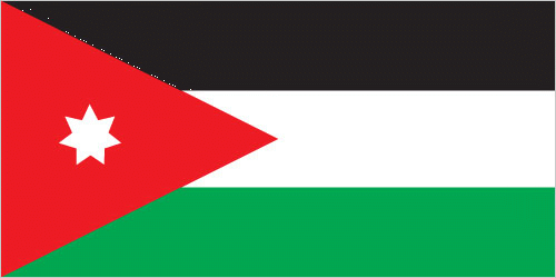
| The national flag of Jordan | Borderline map of Jordan |
| Flag description: three equal horizontal bands of black (top), representing the Abbassid Caliphate, white, representing the Ummayyad Caliphate, and green, representing the Fatimid Caliphate; a red isosceles triangle on the hoist side, representing the Great Arab Revolt of 1916, and bearing a small white seven-pointed star symbolizing the seven verses of the opening Sura (Al-Fatiha) of the Holy Koran; the seven points on the star represent faith in One God, humanity, national spirit, humility, social justice, virtue, and aspirations; design is based on the Arab Revolt flag of World War I. | Border length: total: 1,744 km. Border countries (total: 5): Iraq 179 km, Israel 307 km, Saudi Arabia 731 km, Syria 379 km, West Bank 148 km. |
Did you know about Jordan?
- Originally called Transjordan, as part of the Ottoman Empire, Jordan was officially renamed when independence was gained in 1946.
- The Nabataean ruins of the ancient city of Petra attract thousands of tourists every year.
- The salt of the Dead Sea is collected and used in cooking and preserving food, while some people find the waters have healing properties.
Facts of Jordan (JO)
Name conventional long form: Hashemite Kingdom of Jordan, conventional short form: Jordan, local long form: Al Mamlakah al Urduniyah al Hashimiyah, local short form: Al Urdun, former: Transjordan, etymology: named for the Jordan River, which makes up part of Jordan’s northwest border
Codes: ISO; JO, Internet; .jo
Capital city: Amman
Language(s): Arabic (official language), English (widely understood among upper and middle classes)
National holiday(s): Independence Day, 25 May (1946)
Motto: Allah, Al-Watan, Al-Malik (God, Country, King)
Currency: Jordanian dinar (JOD)
GPS: 31 00 N, 36 00 E, Amman; 31 57 N 35 56 E
Location: Middle East, northwest of Saudi Arabia, between Israel (to the west) and Iraq
Geography note: strategic location at the head of the Gulf of Aqaba and as the Arab country that shares the longest border with Israel and the occupied West Bank
Land boundaries: Iraq 179 km, Israel 307 km, Saudi Arabia 731 km, Syria 379 km, West Bank 148 km, total: 1,744 km
Maritime boundaries: N/A
Coastline: 26 km
Area: total: 89,342 sq km; land: 88,802 sq km, water: 540 sq km (total 34 495,12 mi2), about three-quarters the size of Pennsylvania; slightly smaller than Indiana.
Roadways: total: 7,203 km, paved: 7,203 km (2011)
Waterways: N/A
Local time (capital): UTC+2, 7 hours ahead of Washington DC during Standard Time
Note to the local time: Daylight saving time: +1hr begins last Friday in March; ends last Friday in October
Population in Jordan: 9 903 802
Population in Amman: 2 677 500 (including the metropolitan areas)
Urbanization: urban population: 83.7% of total population (2015)
Major urban areas population: AMMAN (capital) 1.155 million (2015)
Population growth rate: 0.83% (2016 estimate)
Birth rate: 25.5 births / 1,000 population (2016 estimate)
Death rate: 3.8 deaths / 1,000 population (2016 estimate)
Age structure: 0-14 years: 35.04% (male 1,470,865 / female 1,397,057) 15-24 years: 20.12% (male 842,202 / female 804,557) 25-54 years: 36.44% (male 1,491,855 / female 1,491,302) 55-64 years: 4.46% (male 177,720 / female 187,181) 65 years and over: 3.94% (male 151,071 / female 171,574) (2016 estimate)
Median age: total: 22.3 years; male: 21.9 years, female: 22.7 years (2016 estimate)
Ethnic groups: Arab 98%, Circassian 1%, Armenian 1%
Religions: Muslim 97.2% (official; predominantly Sunni), Christian 2.2% (majority Greek Orthodox, but some Greek and Roman Catholics, Syrian Orthodox, Coptic Orthodox, Armenian Orthodox, and Protestant denominations), Buddhist 0.4%, Hindu 0.1%, Jewish
Government type: Unitary parliamentary constitutional monarchy
Legal system: mixed system developed from codes instituted by the Ottoman Empire (based on French law), British common law, and Islamic law
National anthem: Al-Salam Al-Malaki Al-Urdunni (The Royal Anthem of Jordan)
Known national hazards: droughts; periodic earthquakes
Major infectious diseases: N/A
Land use: agricultural land: 11.4%; arable land 2%; permanent crops 1%; permanent pasture 8.4%; forest: 1.1%; other: 87.5% (2011 estimate)
Agricultural products: citrus, tomatoes, cucumbers, olives, strawberries, stone fruits; sheep, poultry, dairy
Industries: tourism, information technology, clothing, fertilizers, potash, phosphate mining, pharmaceuticals, petroleum refining, cement, inorganic chemicals, light manufacturing
Export commodities: textiles, fertilizers, potash, phosphates, vegetables, pharmaceuticals
Main export partners: US 21%, Saudi Arabia 16.5%, Iraq 10.3%, India 8.7%, UAE 4.8%, Kuwait 4.4% (2015)
Import commodities: crude oil, refined petroleum products, machinery, transport equipment, iron, cereals
Main import partners: Saudi Arabia 15.4%, China 12.8%, US 6.2%, Germany 4.7%, UAE 4.2% (2015)
Navigate the countries in Middle East faster and easier while driving, use the interactive Google maps for your driving directions. The continuously updated database contains over 220 countries and territories digitally mapped, hundreds of millions of businesses and places around the world positioned on the map.
Get fresh GPS navigation, traffic, and transit information – no matter what part of Jordan, Amman, any other city and country in Asia, or the world you’re in.
Do you like this Jordan information page? Please don’t forget to share it with others! Thank you.