Iraq Google maps and Driving Directions
Get free driving directions, Google maps, traffic information for Iraq, and Baghdad (GPS: 33 20 N 44 24 E), the capital city of the country located in (the) Middle East, bordering the Persian Gulf, between Iran and Kuwait.
Find any address in Baghdad on the Google map of Iraq (IQ) with ease or calculate your up to date itinerary to and from Iraq or its neighboring counties like Iran, Jordan, Kuwait, Saudi Arabia, Syria, Turkey.
Sightseeing and exploring in Asia starts here, thanks to Google because its Earth Engine combines a multi-petabyte catalog of updated satellite imagery and geospatial datasets with planetary-scale analysis capabilities. Wonder the world, use the satellite map function of the Google maps to explore or see differences on the Earth’s surface, inland, or the surrounding areas of Iraq.
Google Maps Iraq
Oil-rich Iraq is situated in the central Middle East. The last 50 years have been dominated by dictatorship, war, and civil strife. A US-led Coalition ousted Saddam Hussein in April 2003.
Iraq is mostly broad plains; reedy marshes along Iranian border in south with large flooded areas; mountains along borders with Iran and Turkey.
The map above fully covers Iraq with its road routes from cities to towns, road intersections in any region, provinces, prefectures, also with free driving directions in Baghdad or to the neighboring towns and countries. To look at the detailed map about a particular quarter in Baghdad, please click on the area and zoom to the place you are interested in the Google maps of Iraq (IQ).
Be creative, use the extras of this Google map; This is a detailed, clear, zoomable, large road map of Iraq with its administrative divisions; 18 governorates (muhafazat, singular – muhafazah (Arabic); parezgakan, singular – parezga (Kurdish)) and 1 region*; Al Anbar; Al Basrah; Al Muthanna; Al Qadisiyah (Ad Diwaniyah); An Najaf; Arbil (Erbil) (Arabic), Hewler (Kurdish); As Sulaymaniyah (Arabic), Slemani (Kurdish); Babil; Baghdad; Dahuk (Arabic), Dihok (Kurdish); Dhi Qar; Diyala; Karbala’; Kirkuk; Kurdistan Regional Government*; Maysan; Ninawa; Salah ad Din; Wasit.
The interactive map above is also may be used as the satellite map of Iraq, or as a reverse search map for finding an address from its GPS coordinates.
Iraq, a triangle of mountains, desert, and fertile river valley, is bounded on the east by Iran, on the north by Turkey, on the west by Syria and Jordan, and on the south by Saudi Arabia and Kuwait. It is twice the size of Idaho. The country has arid desert land west of the Euphrates, a broad central valley between the Euphrates and the Tigris, and mountains in the northeast.
Iraq (area: 435 244 sq km / 168 048,58 sq mi), where the official language is Arabic, Kurdish, lying in Asia and using the currency; Iraqi dinar (IQD), since 2003, set their clock to UTC+3. That means they are 8 hours ahead of Washington DC during Standard Time in Baghdad, the capital. Note to the time difference: N/A.
The climate in Iraq; Southern deserts have hot, dry summers and mild winters. North has dry summers, but winters can be harsh in the mountains. Rainfall is low.
Geography in a nutshell; Mainly desert. The Tigris and Euphrates rivers water fertile regions and create the southern marshland. Mountains along northeast border.
Click here for more detailed information about Iraq.
Driving directions Iraq
The Google maps and Google Satellite maps of Iraq above showing the country, located next to Iran, Jordan, Kuwait, Saudi Arabia, Syria, Turkey. For your further reference, the latitude and longitude coordinates of Iraq are 33 00 N, 44 00 E , while the capital, Baghdad found at 33 20 N 44 24 E.
When you are traveling around Iraq, Baghdad, or its other cities, use this routing tool, providing up to date route planning service free of charge.
Look no further; get accurate driving directions in Iraq, Middle East, by filling the route planner form below.
Since Google acquired and introduced its digitalized maps in 2004, you’re probably familiar with its base functions, like finding an address or driving directions to locations. Still, Google maps also accommodate bicyclists, pedestrians, and also public transportation with special directions and customizable routes.
About Iraq and the capital, Baghdad
 |
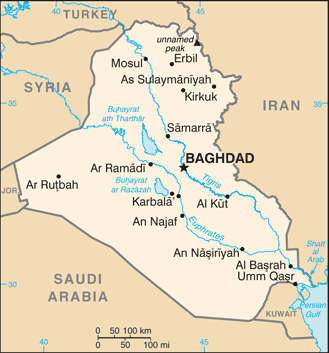 |
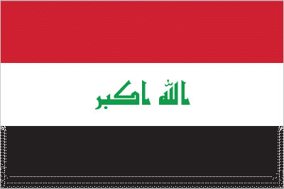
| The national flag of Iraq | Borderline map of Iraq |
| Flag description: three equal horizontal bands of red (top), white, and black; the Takbir (Arabic expression meaning “God is great”) in green Arabic script is centered in the white band; the band colors derive from the Arab Liberation flag and represent oppression (black), overcome through bloody struggle (red), to be replaced by a bright future (white); the Council of Representatives approved this flag in 2008 as a compromise temporary replacement for the Ba’athist SADDAM-era flag. Note: similar to the flag of Syria, which has two stars but no script; Yemen, which has a plain white band; and that of Egypt, which has a golden Eagle of Saladin centered in the white band. | Border length: total: 3,809 km. Border countries (total: 6): Iran 1,599 km, Jordan 179 km, Kuwait 254 km, Saudi Arabia 811 km, Syria 599 km, Turkey 367 km. |
Did you know about Iraq?
- Iraq has been independent since 1932. The republic proclaimed in 1958. Period of instability since 2003, following the overthrow of Saddam Hussein.
- As Mesopotamia, Iraq was the site where the Sumerians established the worlds first civilization.
- Lying across the fertile Tigris and Euphrates river valleys, Iraq is dominated by scorching desert in the south and west of the country, and mountains in its north and east.
Facts of Iraq (IQ)
Name conventional long form: Republic of Iraq, conventional short form: Iraq, local long form: Jumhuriyat al-Iraq/Komar-i Eraq, local short form: Al Iraq/Eraq, etymology: the name probably derives from “Uruk” (Biblical “Erech”), the ancient Sumerian and Babylonian city on the Euphrates River
Codes: ISO; IQ, Internet; .iq
Capital city: Baghdad
Language(s): Arabic (official language), Kurdish (official language), Turkmen (a Turkish dialect) and Assyrian (Neo-Aramaic) are official language in areas where they constitute a majority of the population), Armenian
National holiday(s): Republic Day, July 14 (1958)
Motto: N/A
Currency: Iraqi dinar (IQD), since 2003
GPS: 33 00 N, 44 00 E, Baghdad; 33 20 N 44 24 E
Location: Middle East, bordering the Persian Gulf, between Iran and Kuwait
Geography note: strategic location on Shatt al Arab waterway and at the head of the Persian Gulf
Land boundaries: Iran 1,599 km, Jordan 179 km, Kuwait 254 km, Saudi Arabia 811 km, Syria 599 km, Turkey 367 km, total: 3,809 km
Maritime boundaries: Persian Gulf
Coastline: 58 km
Area: total: 438,317 sq km; land: 437,367 sq km, water: 950 sq km (total 168 048,58 mi2), slightly more than three times the size of New York state.
Roadways: total: 59,623 km, paved: 59,623 km (includes Kurdistan Region) (2012)
Waterways: 5,279 km (the Euphrates River (2,815 km), Tigris River (1,899 km), and Third River (565 km) are the principal waterways) (2012)
Local time (capital): UTC+3, 8 hours ahead of Washington DC during Standard Time
Note to the local time: N/A
Population in Iraq: 39 339 753
Population in Baghdad: 6 777 300 (including the metropolitan areas)
Urbanization: urban population: 69.5% of total population (2015)
Major urban areas population: BAGHDAD (capital) 6.643 million; Mosul 1.694 million; Erbil 1.166 million; Basra 1.019 million; As Sulaymaniyah 1.004 million; Najaf 889,000 (2015)
Population growth rate: 2.87% (2016 estimate)
Birth rate: 30.9 births / 1,000 population (2016 estimate)
Death rate: 3.8 deaths / 1,000 population (2016 estimate)
Age structure: 0-14 years: 39.88% (male 7,766,832 / female 7,445,633) 15-24 years: 19.07% (male 3,703,302 / female 3,572,702) 25-54 years: 33.7% (male 6,499,345 / female 6,354,506) 55-64 years: 3.96% (male 720,976 / female 790,301) 65 years and over: 3.39% (male 574,521 / female 717,907) (2016 estimate)
Median age: total: 19.9 years; male: 19.6 years, female: 20.2 years (2016 estimate)
Ethnic groups: Arab 75%-80%, Kurdish 15%-20%, Turkoman, Assyrian, other 5%
Religions: Muslim (official) 99% (Shia 60%-65%, Sunni 32%-37%), Christian 0.8%, Hindu
Government type: Federal parliamentary republic
Legal system: mixed legal system of civil and Islamic law
National anthem: Mawtini (My Homeland)
Known national hazards: dust storms; sandstorms; floods
Major infectious diseases: The degree of risk(s): intermediatefood or waterborne diseases: bacterial diarrhea, hepatitis A, and typhoid fever (2016)
Land use: agricultural land: 18.1%; arable land 8.4%; permanent crops 0.5%; permanent pasture 9.2%; forest: 1.9%; other: 80% (2011 estimate)
Agricultural products: wheat, barley, rice, vegetables, dates, cotton; cattle, sheep, poultry
Industries: petroleum, chemicals, textiles, leather, construction materials, food processing, fertilizer, metal fabrication/processing
Export commodities: crude oil 99%, crude materials excluding fuels, food, live animals
Main export partners: China 22.6%, India 21.1%, South Korea 11.2%, US 7.8%, Italy 6.7%, Greece 6% (2015)
Import commodities: food, medicine, manufactures
Main import partners: Turkey 20.7%, Syria 19.6%, China 19.2%, US 4.8%, Russia 4.4% (2015)
Navigate the countries in Middle East faster and easier while driving, use the interactive Google maps for your driving directions. The continuously updated database contains over 220 countries and territories digitally mapped, hundreds of millions of businesses and places around the world positioned on the map.
Get fresh GPS navigation, traffic, and transit information – no matter what part of Iraq, Baghdad, any other city and country in Asia, or the world you’re in.
Do you like this Iraq information page? Please don’t forget to share it with others! Thank you.