Lebanon Google maps and Driving Directions
Get free driving directions, Google maps, traffic information for Lebanon, and Beirut (GPS: 33 52 N 35 30 E), the capital city of the country located in (the) Middle East, bordering the Mediterranean Sea, between Israel and Syria.
Find any address in Beirut on the Google map of Lebanon (LB) with ease or calculate your up to date itinerary to and from Lebanon or its neighboring counties like Israel, Syria.
Sightseeing and exploring in Asia starts here, thanks to Google because its Earth Engine combines a multi-petabyte catalog of updated satellite imagery and geospatial datasets with planetary-scale analysis capabilities. Wonder the world, use the satellite map function of the Google maps to explore or see differences on the Earth’s surface, inland, or the surrounding areas of Lebanon.
Google Maps Lebanon
Once a vibrant cultural hotspot, Lebanon suffered badly from years of civil war and occupation until a 1989 peace deal. Reconstruction was reversed by Israeli bombardment in 2006.
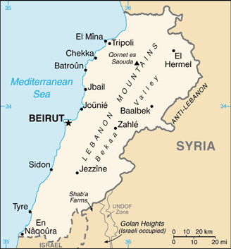
Lebanon is narrow coastal plain; El Beqaa (Bekaa Valley) separates Lebanon and Anti-Lebanon Mountains.
The map above fully covers Lebanon with its road routes from cities to towns, road intersections in any region, provinces, prefectures, also with free driving directions in Beirut or to the neighboring towns and countries. To look at the detailed map about a particular quarter in Beirut, please click on the area and zoom to the place you are interested in the Google maps of Lebanon (LB).
Be creative, use the extras of this Google map; This is a detailed, clear, zoomable, large road map of Lebanon with its administrative divisions; 8 governorates (mohafazat, singular – mohafazah); Aakkar, Baalbek-Hermel, Beqaa, Beyrouth (Beirut), Liban-Nord (North Lebanon), Liban-Sud (South Lebanon), Mont-Liban (Mount Lebanon), Nabatiye.
The interactive map above is also may be used as the satellite map of Lebanon, or as a reverse search map for finding an address from its GPS coordinates.
Lebanon lies at the eastern end of the Mediterranean Sea, north of Israel and west of Syria. It is four-fifths the size of Connecticut. The Lebanon Mountains, which run parallel to the western coast, cover most of the country, while on the eastern border is the Anti-Lebanon range. Between the two lies the Bekaa Valley, the principal agricultural area.
Lebanon (area: 10 452 sq km / 4 035,54 sq mi), where the official language is Arabic, lying in Asia and using the currency; Lebanese pound (LBP), set their clock to UTC+2. That means they are 7 hours ahead of Washington DC during Standard Time in Beirut, the capital. Note to the time difference: Daylight saving time: +1hr begins last Sunday in March; ends last Sunday in October.
The climate in Lebanon; Winters are mild and summers are hot, with high coastal humidity. Snow falls on high ground in winter.
Geography in a nutshell; Behind a narrow Mediterranean coastal plain, two parallel mountain ranges run the length of the country, separated by the fertile Beqaa Valley.
Click here for more detailed information about Lebanon.
Driving directions Lebanon
The Google maps and Google Satellite maps of Lebanon above showing the country, located next to Israel, Syria. For your further reference, the latitude and longitude coordinates of Lebanon are 33 50 N, 35 50 E , while the capital, Beirut found at 33 52 N 35 30 E.
When you are traveling around Lebanon, Beirut, or its other cities, use this routing tool, providing up to date route planning service free of charge.
Look no further; get accurate driving directions in Lebanon, Middle East, by filling the route planner form below.
Since Google acquired and introduced its digitalized maps in 2004, you’re probably familiar with its base functions, like finding an address or driving directions to locations. Still, Google maps also accommodate bicyclists, pedestrians, and also public transportation with special directions and customizable routes.
About Lebanon and the capital, Beirut
 |
 |
| The national flag of Lebanon | Borderline map of Lebanon |
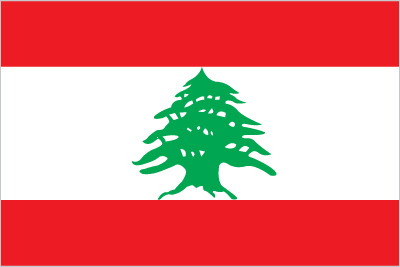
| Flag description: three horizontal bands consisting of red (top), white (middle, double width), and red (bottom) with a green cedar tree centered in the white band; the red bands symbolize bloodshed for liberation, the white band denotes peace, the snow of the mountains, and purity; the green cedar tree is the symbol of Lebanon and represents eternity, steadiness, happiness, and prosperity. | Border length: total: 484 km. Border countries (total: 2): Israel 81 km, Syria 403 km. |
Did you know about Lebanon?
- Lebanon became independent in 1944, after 20 years as a French mandate. The country is currently rebuilding after 14 years of civil war.
- The Cedar of Lebanon has been the nations symbol for more than 2000 years.
- The national symbol of Lebanon, cedar trees survive in a few protected woods and can live for more than 1,500 years.
Facts of Lebanon (LB)
Name conventional long form: Lebanese Republic, conventional short form: Lebanon, local long form: Al Jumhuriyah al Lubnaniyah, local short form: Lubnan, former: Greater Lebanon, etymology: derives from the Semitic root “lbn” meaning “white” and refers to snow-capped Mount Lebanon
Codes: ISO; LB, Internet; .lb
Capital city: Beirut
Language(s): Arabic (official language), French, English, Armenian
National holiday(s): Independence Day, 22 November (1943)
Motto: N/A
Currency: Lebanese pound (LBP)
GPS: 33 50 N, 35 50 E, Beirut; 33 52 N 35 30 E
Location: Middle East, bordering the Mediterranean Sea, between Israel and Syria
Geography note: smallest country in continental Asia; Nahr el Litani is the only major river in Near East not crossing an international boundary; rugged terrain historically helped isolate, protect, and develop numerous factional groups based on religion, clan, and ethnicity
Land boundaries: Israel 81 km, Syria 403 km, total: 484 km
Maritime boundaries: Mediterranean Sea
Coastline: 225 km
Area: total: 10,400 sq km; land: 10,230 sq km, water: 170 sq km (total 4 035,54 mi2), about one-third the size of Maryland.
Roadways: total: 6,970 km (includes 170 km of expressways) (2005)
Waterways: N/A
Local time (capital): UTC+2, 7 hours ahead of Washington DC during Standard Time
Note to the local time: Daylight saving time: +1hr begins last Sunday in March; ends last Sunday in October
Population in Lebanon: 6 093 509
Population in Beirut: 1 916 100 (including the metropolitan areas)
Urbanization: urban population: 87.8% of total population (2015)
Major urban areas population: BEIRUT (capital) 2.226 million (2015)
Population growth rate: 0.85% (2016 estimate)
Birth rate: 14.4 births / 1,000 population (2016 estimate)
Death rate: 4.9 deaths / 1,000 population (2016 estimate)
Age structure: 0-14 years: 24.65% (male 786,842 / female 750,449) 15-24 years: 16.73% (male 534,040 / female 509,663) 25-54 years: 44.44% (male 1,401,857 / female 1,370,462) 55-64 years: 7.54% (male 220,020 / female 250,288) 65 years and over: 6.64% (male 181,627 / female 232,490) (2016 estimate)
Median age: total: 29.9 years; male: 29.3 years, female: 30.5 years (2016 estimate)
Ethnic groups: Arab 95%, Armenian 4%, other 1%note: many Christian Lebanese do not identify themselves as Arab but rather as descendants of the ancient Canaanites and prefer to be called Phoenicians
Religions: Muslim 54% (27% Sunni, 27% Shia), Christian 40.5% (includes 21% Maronite Catholic, 8% Greek Orthodox, 5% Greek Catholic, 6.5% other Christian), Druze 5.6%, very small numbers of Jews, Baha’is, Buddhists, Hindus, and Mormons. Note: 18 religious sects recognized (2012 estimate)
Government type: Unitary parliamentary republic
Legal system: mixed legal system of civil law based on the French civil code, Ottoman legal tradition, and religious laws covering personal status, marriage, divorce, and other family relations of the Jewish, Islamic, and Christian communities
National anthem: All Of Us, For the Country!
Known national hazards: dust storms, sandstorms
Major infectious diseases: N/A
Land use: agricultural land: 63.3%; arable land 11.9%; permanent crops 12.3%; permanent pasture 39.1%; forest: 13.4%; other: 23.3% (2011 estimate)
Agricultural products: citrus, grapes, tomatoes, apples, vegetables, potatoes, olives, tobacco; sheep, goats
Industries: banking, tourism, food processing, wine, jewelry, cement, textiles, mineral and chemical products, wood and furniture products, oil refining, metal fabricating
Export commodities: jewelry, base metals, chemicals, consumer goods, fruit and vegetables, tobacco, construction minerals, electric power machinery and switchgear, textile fibers, paper
Main export partners: Saudi Arabia 12.1%, UAE 10.6%, Iraq 7.6%, Syria 7.1%, South Africa 6.6% (2015)
Import commodities: petroleum products, cars, medicinal products, clothing, meat and live animals, consumer goods, paper, textile fabrics, tobacco, electrical machinery and equipment, chemicals
Main import partners: China 11.5%, Italy 7.1%, Germany 6.8%, France 6%, US 5.7%, Russia 4.6%, Greece 4.4% (2015)
Navigate the countries in Middle East faster and easier while driving, use the interactive Google maps for your driving directions. The continuously updated database contains over 220 countries and territories digitally mapped, hundreds of millions of businesses and places around the world positioned on the map.
Get fresh GPS navigation, traffic, and transit information – no matter what part of Lebanon, Beirut, any other city and country in Asia, or the world you’re in.
Do you like this Lebanon information page? Please don’t forget to share it with others! Thank you.