Iran Google maps and Driving Directions
Get free driving directions, Google maps, traffic information for Iran, and Tehran (GPS: 35 42 N 51 25 E), the capital city of the country located in (the) Middle East, bordering the Gulf of Oman, the Persian Gulf, and the Caspian Sea, between Iraq and Pakistan.
Find any address in Tehran on the Google map of Iran (IR) with ease or calculate your up to date itinerary to and from Iran or its neighboring counties like Afghanistan, Armenia, Azerbaijan, Iraq, Pakistan, Turkey, Turkmenistan.
Sightseeing and exploring in Asia starts here, thanks to Google because its Earth Engine combines a multi-petabyte catalog of updated satellite imagery and geospatial datasets with planetary-scale analysis capabilities. Wonder the world, use the satellite map function of the Google maps to explore or see differences on the Earth’s surface, inland, or the surrounding areas of Iran.
Google Maps Iran
Since the 1979 Islamic fundamentalist revolution led by Ayatollah Khomeini, the Middle Eastern country of Iran has been the worlds largest theocracy.
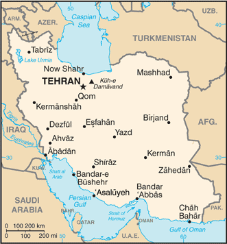
Iran is rugged, mountainous rim; high, central basin with deserts, mountains; small, discontinuous plains along both coasts.
The map above fully covers Iran with its road routes from cities to towns, road intersections in any region, provinces, prefectures, also with free driving directions in Tehran or to the neighboring towns and countries. To look at the detailed map about a particular quarter in Tehran, please click on the area and zoom to the place you are interested in the Google maps of Iran (IR).
Be creative, use the extras of this Google map; This is a detailed, clear, zoomable, large road map of Iran with its administrative divisions; 31 provinces (ostanha, singular – ostan); Alborz, Ardabil, Azarbayjan-e Gharbi (West Azerbaijan), Azarbayjan-e Sharqi (East Azerbaijan), Bushehr, Chahar Mahal va Bakhtiari, Esfahan, Fars, Gilan, Golestan, Hamadan, Hormozgan, Ilam, Kerman, Kermanshah, Khorasan-e Jonubi (South Khorasan), Khorasan-e Razavi (Razavi Khorasan), Khorasan-e Shomali (North Khorasan), Khuzestan, Kohgiluyeh va Bowyer Ahmad, Kordestan, Lorestan, Markazi, Mazandaran, Qazvin, Qom, Semnan, Sistan va Baluchestan, Tehran, Yazd, Zanjan.
The interactive map above is also may be used as the satellite map of Iran, or as a reverse search map for finding an address from its GPS coordinates.
Iran, a Middle Eastern country south of the Caspian Sea and north of the Persian Gulf, is three times the size of Arizona. It shares borders with Iraq, Turkey, Azerbaijan, Turkmenistan, Armenia, Afghanistan, and Pakistan. The Elburz Mountains in the north rise to 18,603 ft (5,670 m) at Mount Damavend. From northwest to southeast, the country is crossed by a desert 800 mi (1,287 km) long.
Iran (area: 1 648 200 sq km / 636 373,32 sq mi), where the official language is Persian, lying in Asia and using the currency; Iranian rial (IRR), since 1932, set their clock to UTC+3.5. That means they are 8.5 hours ahead of Washington DC during Standard Time in Tehran, the capital. Note to the time difference: Daylight saving time: +1hr begins fourth Tuesday in March; ends fourth Thursday in September.
The climate in Iran; Desert climate. Hot summers, and bitterly cold winters. Area around the Caspian Sea is more temperate.
Geography in a nutshell; High desert plateau with large salt pans in the east. West and north are mountainous. Coastal land bordering Caspian Sea is rainy and forested.
Click here for more detailed information about Iran.
Driving directions Iran
The Google maps and Google Satellite maps of Iran above showing the country, located next to Afghanistan, Armenia, Azerbaijan, Iraq, Pakistan, Turkey, Turkmenistan. For your further reference, the latitude and longitude coordinates of Iran are 32 00 N, 53 00 E , while the capital, Tehran found at 35 42 N 51 25 E.
When you are traveling around Iran, Tehran, or its other cities, use this routing tool, providing up to date route planning service free of charge.
Look no further; get accurate driving directions in Iran, Middle East, by filling the route planner form below.
Since Google acquired and introduced its digitalized maps in 2004, you’re probably familiar with its base functions, like finding an address or driving directions to locations. Still, Google maps also accommodate bicyclists, pedestrians, and also public transportation with special directions and customizable routes.
About Iran and the capital, Tehran
 |
 |
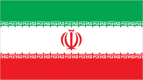
| The national flag of Iran | Borderline map of Iran |
| Flag description: three equal horizontal bands of green (top), white, and red; the national emblem (a stylized representation of the word Allah in the shape of a tulip, a symbol of martyrdom) in red is centered in the white band; ALLAH AKBAR (God is Great) in white Arabic script is repeated 11 times along the bottom edge of the green band and 11 times along the top edge of the red band; green is the color of Islam and also represents growth, white symbolizes honesty and peace, red stands for bravery and martyrdom. | Border length: total: 5,894 km. Border countries (total: 7): Afghanistan 921 km, Armenia 44 km, Azerbaijan 689 km, Iraq 1,599 km, Pakistan 959 km, Turkey 534 km, Turkmenistan 1,148 km. |
Did you know about Iran?
- Iran was a monarchy until 1979, when the Ayatollah Khomeini deposed the Shah. An Islamic republic was formed in 1980.
- More than a hundred offenses carry the death penalty.
- Islamic spiritual leaders have governed the ancient country of Iran since 1979, making it one of the only two theocracies in the world.
Facts of Iran (IR)
Name conventional long form: Islamic Republic of Iran, conventional short form: Iran, local long form: Jomhuri-ye Eslami-ye Iran, local short form: Iran, former: Persia, etymology: name derives from the Avestan term “aryanam” meaning “Land of the noble [ones]”
Codes: ISO; IR, Internet; .ir
Capital city: Tehran
Language(s): Persian (official language), Azeri Turkic and Turkic dialects, Kurdish, Gilaki and Mazandarani, Luri, Balochi, Arabic, other
National holiday(s): Republic Day, 1 April (1979)
Motto: Independence, freedom, the Islamic Republic
Currency: Iranian rial (IRR), since 1932
GPS: 32 00 N, 53 00 E, Tehran; 35 42 N 51 25 E
Location: Middle East, bordering the Gulf of Oman, the Persian Gulf, and the Caspian Sea, between Iraq and Pakistan
Geography note: strategic location on the Persian Gulf and Strait of Hormuz, which are vital maritime pathways for crude oil transport
Land boundaries: Afghanistan 921 km, Armenia 44 km, Azerbaijan 689 km, Iraq 1,599 km, Pakistan 959 km, Turkey 534 km, Turkmenistan 1,148 km, total: 5,894 km
Maritime boundaries: N/A
Coastline: 2,440 km; note – Iran also borders the Caspian Sea (740 km)
Area: total: 1,648,195 sq km; land: 1,531,595 sq km, water: 116,600 sq km (total 636 373,32 mi2), almost 2.5 times the size of Texas; slightly smaller than Alaska.
Roadways: total: 198,866 km, paved: 160,366 km (includes 1,948 km of expressways), unpaved: 38,500 km (2010)
Waterways: 850 km (on Karun River; some navigation on Lake Urmia) (2012)
Local time (capital): UTC+3.5, 8.5 hours ahead of Washington DC during Standard Time
Note to the local time: Daylight saving time: +1hr begins fourth Tuesday in March; ends fourth Thursday in September
Population in Iran: 82 011 735
Population in Tehran: 7 796 257 (including the metropolitan areas)
Urbanization: urban population: 73.4% of total population (2015)
Major urban areas population: TEHRAN (capital) 8.432 million; Mashhad 3.014 million; Esfahan 1.88 million; Karaj 1.807 million; Shiraz 1.661 million; Tabriz 1.572 million (2015)
Population growth rate: 1.18% (2016 estimate)
Birth rate: 17.8 births / 1,000 population (2016 estimate)
Death rate: 5.9 deaths / 1,000 population (2016 estimate)
Age structure: 0-14 years: 23.65% (male 10,037,814 / female 9,546,710) 15-24 years: 16.57% (male 7,041,801 / female 6,675,656) 25-54 years: 47.59% (male 20,085,331 / female 19,319,933) 55-64 years: 6.79% (male 2,770,618 / female 2,855,362) 65 years and over: 5.4% (male 2,052,541 / female 2,415,867) (2016 estimate)
Median age: total: 29.4 years; male: 29.1 years, female: 29.7 years (2016 estimate)
Ethnic groups: Persian, Azeri, Kurd, Lur, Baloch, Arab, Turkmen and Turkic tribes
Religions: Muslim (official) 99.4% (Shia 90-95%, Sunni 5-10%), other (includes Zoroastrian, Jewish, and Christian) 0.3%, unspecified 0.4% (2011 estimate)
Government type: Islamic Republic
Legal system: religious legal system based on secular and Islamic law
National anthem: Sorude Melliye Jomhuriye Eslâmiye Irân
Known national hazards: periodic droughts, floods; dust storms, sandstorms; earthquakes
Major infectious diseases: The degree of risk(s): intermediatefood or waterborne diseases: bacterial diarrheavectorborne diseases: Crimean-Congo hemorrhagic fever (2016)
Land use: agricultural land: 30.1%; arable land 10.8%; permanent crops 1.2%; permanent pasture 18.1%; forest: 6.8%; other: 63.1% (2011 estimate)
Agricultural products: wheat, rice, other grains, sugar beets, sugarcane, fruits, nuts, cotton; dairy products, wool; caviar
Industries: petroleum, petrochemicals, gas, fertilizers, caustic soda, textiles, cement and other construction materials, food processing (particularly sugar refining and vegetable oil production), ferrous and nonferrous metal fabrication, armaments
Export commodities: petroleum 80%, chemical and petrochemical products, fruits and nuts, carpets, cement, ore
Main export partners: China 22.2%, India 9.9%, Turkey 8.4%, Japan 4.5% (2015)
Import commodities: industrial supplies, capital goods, foodstuffs and other consumer goods, technical services
Main import partners: UAE 39.6%, China 22.4%, South Korea 4.7%, Turkey 4.6% (2015)
Navigate the countries in Middle East faster and easier while driving, use the interactive Google maps for your driving directions. The continuously updated database contains over 220 countries and territories digitally mapped, hundreds of millions of businesses and places around the world positioned on the map.
Get fresh GPS navigation, traffic, and transit information – no matter what part of Iran, Tehran, any other city and country in Asia, or the world you’re in.
Do you like this Iran information page? Please don’t forget to share it with others! Thank you.