Spain Google maps and Driving Directions
Get free driving directions, Google maps, traffic information for Spain, and Madrid (GPS: 40 24 N 3 41 W), the capital city of the country located in (the) Southwestern Europe, bordering the Mediterranean Sea, North Atlantic Ocean, Bay of Biscay, and Pyrenees Mountains; southwest of France.
Find any address in Madrid on the Google map of Spain (ES) with ease or calculate your up to date itinerary to and from Spain or its neighboring counties like Andorra, France, Morocco, Portugal.
Sightseeing and exploring in Europe starts here, thanks to Google because its Earth Engine combines a multi-petabyte catalog of updated satellite imagery and geospatial datasets with planetary-scale analysis capabilities. Wonder the world, use the satellite map function of the Google maps to explore or see differences on the Earth’s surface, inland, or the surrounding areas of Spain.
Google Maps Spain
Lodged between Europe, Africa, the North Atlantic, and the Mediterranean, Spain has occupied a pivotal global position since unification under Ferdinand and Isabella in 1492.
Spain is large, flat to dissected plateau surrounded by rugged hills; Pyrenees Mountains in north.
The map above fully covers Spain with its road routes from cities to towns, road intersections in any region, provinces, prefectures, also with free driving directions in Madrid or to the neighboring towns and countries. To look at the detailed map about a particular quarter in Madrid, please click on the area and zoom to the place you are interested in the Google maps of Spain (ES).
Be creative, use the extras of this Google map; This is a detailed, clear, zoomable, large road map of Spain with its administrative divisions; 17 semi-autonomous communities (comunidades autonomas, singular – comunidad autonoma) and 2 autonomous cities* (ciudades autonomas, singular – ciudad autonoma); Andalucia; Aragon; Asturias; Canarias (Canary Islands); Cantabria; Castilla-La Mancha; Castilla-Leon; Cataluna (Castilian), Catalunya (Catalan), Catalonha (Aranese) [Catalonia]; Ceuta*; Comunidad Valenciana (Castilian), Comunitat Valenciana (Valencian) [Valencian Community]; Extremadura; Galicia; Illes Baleares (Balearic Islands); La Rioja; Madrid; Melilla*; Murcia; Navarra (Castilian), Nafarroa (Basque) [Navarre]; Pais Vasco (Castilian), Euskadi (Basque) [Basque Country]note: the autonomous cities of Ceuta and Melilla plus three small islands of Islas Chafarinas, Penon de Alhucemas, and Penon de Velez de la Gomera, administered directly by the Spanish central government, are all along the coast of Morocco and are collectively referred to as Places of Sovereignty (Plazas de Soberania).
The interactive map above is also may be used as the satellite map of Spain, or as a reverse search map for finding an address from its GPS coordinates.
Spain occupies 85% of the Iberian Peninsula, which it shares with Portugal, in southwest Europe. Africa is less than 10 mi (16 km) south at the Strait of Gibraltar. A broad central plateau slopes to the south and east, crossed by a series of mountain ranges and river valleys. Principal rivers are the Ebro in the northeast, the Tajo in the central region, and the Guadalquivir in the south. Off Spain’s east coast in the Mediterranean are the Balearic Islands (1,936 sq mi 5,014 sq km), the largest of which is Majorca. Sixty mi (97 km) west of Africa are the Canary Islands (2,808 sq mi 7,273 sq km).
Spain (area: 505 992 sq km / 195 364,52 sq mi), where the official language is Spanish, lying in Europe and using the currency; Euro (EUR), since 1999, set their clock to UTC+1. That means they are 6 hours ahead of Washington DC during Standard Time in Madrid, the capital. Note to the time difference: Daylight saving time: +1hr begins last Sunday in March; ends last Sunday in October. Note: Spain has two time zones including the Canary Islands.
The climate in Spain; Maritime in north. Hotter and drier in south. The central plateau has an extreme climate.
Geography in a nutshell; Mountain ranges in the north, center, and south, with a huge central plateau. Mediterranean lowlands. Verdant valleys in the north west.
Click here for more detailed information about Spain.
Driving directions Spain
The Google maps and Google Satellite maps of Spain above showing the country, located next to Andorra, France, Morocco, Portugal. For your further reference, the latitude and longitude coordinates of Spain are 40 00 N, 4 00 W , while the capital, Madrid found at 40 24 N 3 41 W.
When you are traveling around Spain, Madrid, or its other cities, use this routing tool, providing up to date route planning service free of charge.
Look no further; get accurate driving directions in Spain, Europe, by filling the route planner form below.
Since Google acquired and introduced its digitalized maps in 2004, you’re probably familiar with its base functions, like finding an address or driving directions to locations. Still, Google maps also accommodate bicyclists, pedestrians, and also public transportation with special directions and customizable routes.
About Spain and the capital, Madrid
 |
 |
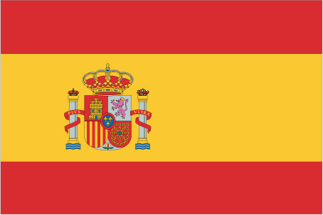
| The national flag of Spain | Borderline map of Spain |
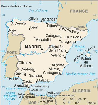
| Flag description: three horizontal bands of red (top), yellow (double width), and red with the national coat of arms on the hoist side of the yellow band; the coat of arms is quartered to display the emblems of the traditional kingdoms of Spain (clockwise from upper left, Castile, Leon, Navarre, and Aragon) while Granada is represented by the stylized pomegranate at the bottom of the shield; the arms are framed by two columns representing the Pillars of Hercules, which are the two promontories (Gibraltar and Ceuta) on either side of the eastern end of the Strait of Gibraltar; the red scroll across the two columns bears the imperial motto of “Plus Ultra” (further beyond) referring to Spanish lands beyond Europe; the triband arrangement with the center stripe twice the width of the outer dates to the 18th century. Note: the red and yellow colors are related to those of the oldest Spanish kingdoms: Aragon, Castile, Leon, and Navarre. | Border length: total: 1,952.7 km. Border countries (total: 5): Andorra 63 km, France 646 km, Gibraltar 1.2 km, Portugal 1,224 km, Morocco (Ceuta) 8 km, Morocco (Melilla) 10.5 km. Note: an additional 75-meter border segment exists between Morocco and the Spanish exclave of Penon de Velez de la Gomera. |
About Madrid
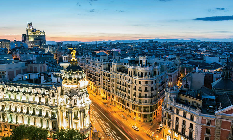
Madrid built to rule, established on a broad, flat plateau in the geographical center of the Iberian peninsula to bring Spain’s many fractious regions together. It’s no wonder, then, that Madrid is Spain’s melting pot. Native Madrileños are joined here not only by Basques, Galicians, Catalonians, and Andalusians but by immigrants from Africa and South America. Far from the sea and lacking the multi-millennial history of Barcelona or Seville, Madrid can still claim more than its fair share of world-class attractions: its impressive royal palace, beautiful parks, the wealth of art museums, and passionate and diverse population. Madrileños work hard and party even harder, dining at midnight and dancing until dawn in throbbing, multilevel nightclubs or whiling away the evening in smoky, atmospheric tapas bars.
Renovation and reconstruction are everywhere in Madrid, whether invisible in the lifted gloom of the Chueca neighborhood, once a dangerous, crime-ridden area and now the city’s hottest nightlife district, or thrillingly evident in the modern wings of the Prado, Thyssen, and Reina Sofia museums, three of Spain’s most significant temples of art. The result of all this work is a city of comfortable, well-lighted plazas and winding yet approachable streets and a population that looks to the future with power and pride.
Did you know about Spain?
- Spain united in the 15th century and rapidly became an imperial power. It lost most of its colonies during the 19th century.
- Over 3000 festivals and feasts take place each year in Spain.
- The south of Spain was once occupied by the Islamic Moors, who left behind many beautiful buildings.
Spain includes the Balearic Islands in the Mediterranean Sea, the Canary Islands in the Atlantic Ocean and the enclaves of Ceuta and Melilla on the coast of Morocco in North Africa.
Spain has a long Mediterranean coast and is a largely mountainous country with a dry, elevated central plateau called the Meseta. The two principal mountain ranges are the Pyrenees, which straddle the border with France, and the Sierra Nevada, which runs roughly west to east behind the Mediterranean coast. Considerable areas of Spain are relatively wild and uninhabited and are home to some of Europe’s rarer animals, such as the wolf, lynx, wildcat and mountain goat.
Agriculture and fishing still play a significant role in the country’s economy, and while traditional industries such as shipbuilding, iron and steel and textiles have declined, there has been considerable expansion in new areas such as information technology and electronics. The country has useful reserves of iron ore, copper, lead, zinc, mercury, gypsum, and silver but poor fossil fuel reserves. Electricity is generated from hydroelectric schemes and nuclear power and through the burning of mainly imported fossil fuels.
Tourism makes a significant contribution to the economy. Each year, numerous visitors come to enjoy Spain’s Mediterranean coastal resorts, historical cities and the unspoiled towns and villages of its interior.
Madrid
Spain’s capital city located in the center of the country in the dry, plateau region and there has been a settlement on the site since Roman times. Most of Madrid’s grand and beautiful buildings, including the famous Prado museum, were constructed in the mid-to-late 18th century. These form the historic heart of the city which has remained relatively unspoiled by the massive growth and urban sprawl that has developed around it. The museums and art galleries in the center of Madrid, particularly the Prado National Museum, the Thyssen-Bornemisza Museum, and the Centro de Arte Reina Sofia National Museum, together house one of the world’s greatest art collections. Of particular importance is the Prado Museum, which is home to an extensive collection of Spanish art, including works by El Greco, Velásquez, Goya, Murillo, Ribera, and Zubaran.
Facts of Spain (ES)
Name conventional long form: Kingdom of Spain, conventional short form: Spain, local long form: Reino de Espana, local short form: Espana, etymology: derivation of the name “Espana” is uncertain, but may come from the Phoenician term “span,” related to the word “spy,” meaning “to forge metals,” so, “i-spn-ya” would mean “place where metals are forged”; the ancient Phoenicians long exploited the Iberian Peninsula for its mineral wealth
Codes: ISO; ES, Internet; .es
Capital city: Madrid
Language(s): Castilian Spanish (official language nationwide) 74%, Catalan (official language in Catalonia, the Balearic Islands, and the Valencian Community (where it is known as Valencian)) 17%, Galician (official language in Galicia) 7%, Basque (official language in the Basque Country and in the Basque-speaking area of Navarre) 2%, Aranese (official language in the northwest corner of Catalonia (Vall d’Aran) along with Catalan;
National holiday(s): National Day, 12 October (1492); year when Columbus first set foot in the Americas
Motto: Plus Ultra (Further Beyond)
Currency: Euro (EUR), since 1999
GPS: 40 00 N, 4 00 W, Madrid; 40 24 N 3 41 W
Location: Southwestern Europe, bordering the Mediterranean Sea, North Atlantic Ocean, Bay of Biscay, and Pyrenees Mountains; southwest of France
Geography note: strategic location along approaches to Strait of Gibraltar; Spain controls a number of territories in northern Morocco including the enclaves of Ceuta and Melilla, and the islands of Penon de Velez de la Gomera, Penon de Alhucemas, and Islas Chafarinas
Land boundaries: Andorra 63 km, France 646 km, Gibraltar 1.2 km, Portugal 1,224 km, Morocco (Ceuta) 8 km, Morocco (Melilla) 10.5 km. Note: an additional 75-meter border segment exists between Morocco and the Spanish exclave of Penon de Velez de la Gomera, total: 1,952.7 km
Maritime boundaries: N/A
Coastline: 4,964 km
Area: total: 505,370 sq km; land: 498,980 sq km, water: 6,390 sq km (total 195 364,52 mi2), almost five times the size of Kentucky; slightly more than twice the size of Oregon.
Roadways: total: 683,175 km, paved: 683,175 km (includes 16,205 km of expressways) (2011)
Waterways: 1,000 km (2012)
Local time (capital): UTC+1, 6 hours ahead of Washington DC during Standard Time
Note to the local time: Daylight saving time: +1hr begins last Sunday in March; ends last Sunday in October. Note: Spain has two time zones including the Canary Islands
Population in Spain: 46 397 452
Population in Madrid: 6 574 000 (including the metropolitan areas)
Urbanization: urban population: 79.6% of total population (2015)
Major urban areas population: MADRID (capital) 6.199 million; Barcelona 5.258 million; Valencia 810,000 (2015)
Population growth rate: 0.84% (2016 estimate)
Birth rate: 9.4 births / 1,000 population (2016 estimate)
Death rate: 9.1 deaths / 1,000 population (2016 estimate)
Age structure: 0-14 years: 15.43% (male 3,854,687 / female 3,638,288) 15-24 years: 9.56% (male 2,400,188 / female 2,243,311) 25-54 years: 45.24% (male 11,200,786 / female 10,771,652) 55-64 years: 11.91% (male 2,820,933 / female 2,963,050) 65 years and over: 17.85% (male 3,700,832 / female 4,969,749) (2016 estimate)
Median age: total: 42.3 years; male: 41.2 years, female: 43.6 years (2016 estimate)
Ethnic groups: composite of Mediterranean and Nordic types
Religions: Roman Catholic 94%, other 6%
Government type: Unitary parliamentary constitutional monarchy
Legal system: civil law system with regional variations
National anthem: Marcha Real (Royal March)
Known national hazards: periodic droughts, occasional floodingvolcanism: volcanic activity in the Canary Islands, located off Africa’s northwest coast; Teide (elev. 3,715 m) has been deemed a Decade Volcano by the International Association of Volcanology and Chemistry of the Earth’s Interior, worthy of study due to its explosive history and proximity to human populations; La Palma (elev. 2,426 m), which last erupted in 1971, is the most active of the Canary Islands volcanoes; Lanzarote is the only other historically active volcano
Major infectious diseases: N/A
Land use: agricultural land: 54.1%; arable land 24.9%; permanent crops 9.1%; permanent pasture 20.1%; forest: 36.8%; other: 9.1% (2011 estimate)
Agricultural products: grain, vegetables, olives, wine grapes, sugar beets, citrus; beef, pork, poultry, dairy products; fish
Industries: textiles and apparel (including footwear), food and beverages, metals and metal manufactures, chemicals, shipbuilding, automobiles, machine tools, tourism, clay and refractory products, footwear, pharmaceuticals, medical equipment
Export commodities: machinery, motor vehicles; foodstuffs, pharmaceuticals, medicines, other consumer goods
Main export partners: France 15.7%, Germany 11%, Italy 7.4%, UK 7.4%, Portugal 7.1%, US 4.5% (2015)
Import commodities: machinery and equipment, fuels, chemicals, semi-finished goods, foodstuffs, consumer goods, measuring and medical control instruments
Main import partners: Germany 14.4%, France 11.7%, China 7.1%, Italy 6.5%, Netherlands 5%, UK 4.9% (2015)
Navigate the countries in Europe faster and easier while driving, use the interactive Google maps for your driving directions. The continuously updated database contains over 220 countries and territories digitally mapped, hundreds of millions of businesses and places around the world positioned on the map.
Get fresh GPS navigation, traffic, and transit information – no matter what part of Spain, Madrid, any other city and country in Europe, or the world you’re in.
Do you like this Spain information page? Please don’t forget to share it with others! Thank you.