Andorra Google maps and Driving Directions
Get free driving directions, Google maps, traffic information for Andorra, and Andorra la Vella (GPS: 42 30 N 1 31 E), the capital city of the country located in (the) Southwestern Europe, Pyrenees mountains, on the border between France and Spain.
Find any address in Andorra la Vella on the Google map of Andorra (AD) with ease or calculate your up to date itinerary to and from Andorra or its neighboring counties like France, Spain.
Sightseeing and exploring in Europe starts here, thanks to Google because its Earth Engine combines a multi-petabyte catalog of updated satellite imagery and geospatial datasets with planetary-scale analysis capabilities. Wonder the world, use the satellite map function of the Google maps to explore or see differences on the Earth’s surface, inland, or the surrounding areas of Andorra.
Google Maps Andorra
A tiny landlocked principality, Andorra lies high in the eastern Pyrenees between France and Spain. It held its first full elections in 1993. Tourism is the main source of income.
Andorra is rugged mountains dissected by narrow valleys.
The map above fully covers Andorra with its road routes from cities to towns, road intersections in any region, provinces, prefectures, also with free driving directions in Andorra la Vella or to the neighboring towns and countries. To look at the detailed map about a particular quarter in Andorra la Vella, please click on the area and zoom to the place you are interested in the Google maps of Andorra (AD).
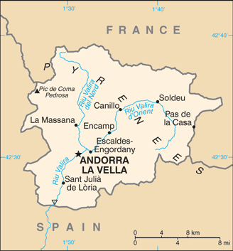
Be creative, use the extras of this Google map; This is a detailed, clear, zoomable, large road map of Andorra with its administrative divisions; 7 parishes (parroquies, singular – parroquia); Andorra la Vella, Canillo, Encamp, Escaldes-Engordany, La Massana, Ordino, Sant Julia de Loria.
The interactive map above is also may be used as the satellite map of Andorra, or as a reverse search map for finding an address from its GPS coordinates.
Andorra is nestled high in the Pyrénées Mountains on the French-Spanish border.
Andorra (area: 468 sq km / 180,7 sq mi), where the official language is Catalan, lying in Europe and using the currency; Euro (EUR), since 1999, set their clock to UTC+1. That means they are 6 hours ahead of Washington DC during Standard Time in Andorra la Vella, the capital. Note to the time difference: Daylight saving time: +1hr begins last Sunday in March; ends last Sunday in October.
The climate in Andorra; Cool, wet springs followed by dry, warm summers. Mountain snows linger until March.
Geography in a nutshell; High mountains, with six deep, glaciated valleys that drain into the Valira River as it flows into Spain.
Click here for more detailed information about Andorra.
Driving directions Andorra
The Google maps and Google Satellite maps of Andorra above showing the country, located next to France, Spain. For your further reference, the latitude and longitude coordinates of Andorra are 42 30 N, 1 30 E , while the capital, Andorra la Vella found at 42 30 N 1 31 E.
When you are traveling around Andorra, Andorra la Vella, or its other cities, use this routing tool, providing up to date route planning service free of charge.
Look no further; get accurate driving directions in Andorra, Europe, by filling the route planner form below.
Since Google acquired and introduced its digitalized maps in 2004, you’re probably familiar with its base functions, like finding an address or driving directions to locations. Still, Google maps also accommodate bicyclists, pedestrians, and also public transportation with special directions and customizable routes.
About Andorra and the capital, Andorra la Vella
 |
 |
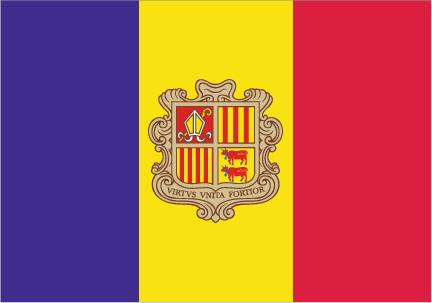
| The national flag of Andorra | Borderline map of Andorra |
| Flag description: three vertical bands of blue (hoist side), yellow, and red, with the national coat of arms centered in the yellow band; the latter band is slightly wider than the other two so that the ratio of band widths is 8:9:8; the coat of arms features a quartered shield with the emblems of (starting in the upper left and proceeding clockwise): Urgell, Foix, Bearn, and Catalonia; the motto reads VIRTUS UNITA FORTIOR (Strength United is Stronger); the flag combines the blue and red French colors with the red and yellow of Spain to show Franco-Spanish protection. Note: similar to the flags of Chad and Romania, which do not have a national coat of arms in the center, and the flag of Moldova, which does bear a national emblem. | Border length: total: 118 km. Border countries (total: 2): France 55 km, Spain 63 km. |
Did you know about Andorra?
- The Principality of Andorra is an independent republic in the Pyrenees, between France and Spain. It is one of the worlds oldest states.
- Andorras coprincipality status dates from the 13th century. The “princes are the president of France and the bishop of Urgel in Spain.
Facts of Andorra (AD)
Name conventional long form: Principality of Andorra, conventional short form: Andorra, local long form: Principat d’Andorra, local short form: Andorra, etymology: the origin of the country’s name is obscure; since the area served as part of the Spanish March (defensive buffer zone) against the invading Moors in the 8th century, the name may derive from the Arabic “ad-darra” meaning “the forest”
Codes: ISO; AD, Internet; .ad
Capital city: Andorra la Vella
Language(s): Catalan (official language), French, Castilian, Portuguese
National holiday(s): Our Lady of Meritxell Day, 8 September (1278)
Motto: Virtus Unita Fortior (United virtue is stronger)
Currency: Euro (EUR), since 1999
GPS: 42 30 N, 1 30 E, Andorra la Vella; 42 30 N 1 31 E
Location: Southwestern Europe, Pyrenees mountains, on the border between France and Spain
Geography note: landlocked country; straddles a number of important crossroads in the Pyrenees
Land boundaries: France 55 km, Spain 63 km, total: 118 km
Maritime boundaries: N/A
Coastline: 0 km (landlocked country)
Area: total: 468 sq km; land: 468 sq km, water: 0 sq km (total 180,7 mi2), 2.5 times the size of Washington, DC.
Roadways: total: 320 km (2008)
Waterways: N/A
Local time (capital): UTC+1, 6 hours ahead of Washington DC during Standard Time
Note to the local time: Daylight saving time: +1hr begins last Sunday in March; ends last Sunday in October
Population in Andorra: 76 953
Population in Andorra la Vella: 23 000 (including the metropolitan areas)
Urbanization: urban population: 85.1% of total population (2015)
Major urban areas population: ANDORRA LA VELLA (capital) 23,000 (2014)
Population growth rate: 0.07% (2016 estimate)
Birth rate: 7.8 births / 1,000 population (2016 estimate)
Death rate: 7.1 deaths / 1,000 population (2016 estimate)
Age structure: 0-14 years: 14.74% (male 6,476 / female 6,151) 15-24 years: 9.52% (male 4,236 / female 3,915) 25-54 years: 47.01% (male 20,614 / female 19,651) 55-64 years: 13.59% (male 6,229 / female 5,412) 65 years and over: 15.15% (male 6,566 / female 6,410) (2016 estimate)
Median age: total: 43.7 years; male: 43.8 years, female: 43.5 years (2016 estimate)
Ethnic groups: Andorran 49%, Spanish 24.6%, Portuguese 14.3%, French 3.9%, other 8.2% (2012 estimate)
Religions: Roman Catholic (predominant)
Government type: Unitary parliamentary Semi-Elective diarchy
Legal system: mixed legal system of civil and customary law with the influence of canon law
National anthem: El Gran Carlemany (The Great Charlemagne)
Known national hazards: avalanches
Major infectious diseases: N/A
Land use: agricultural land: 43.4%; arable land 5.5%; permanent crops 0%; permanent pasture 37.9%; forest: 34%; other: 22.6% (2011 estimate)
Agricultural products: small quantities of rye, wheat, barley, oats, vegetables, tobacco; sheep, cattle
Industries: tourism (particularly skiing), banking, timber, furniture
Export commodities: tobacco products, furniture
Main export partners: N/A
Import commodities: consumer goods, food, fuel, electricity
Main import partners: N/A
Navigate the countries in Europe faster and easier while driving, use the interactive Google maps for your driving directions. The continuously updated database contains over 220 countries and territories digitally mapped, hundreds of millions of businesses and places around the world positioned on the map.
Get fresh GPS navigation, traffic, and transit information – no matter what part of Andorra, Andorra la Vella, any other city and country in Europe, or the world you’re in.
Do you like this Andorra information page? Please don’t forget to share it with others! Thank you.