Morocco Google maps and Driving Directions
Get free driving directions, Google maps, traffic information for Morocco, and Rabat (GPS: 34 01 N 6 49 W), the capital city of the country located in (the) Northern Africa, bordering the North Atlantic Ocean and the Mediterranean Sea, between Algeria and Western Sahara.
Find any address in Rabat on the Google map of Morocco (MA) with ease or calculate your up to date itinerary to and from Morocco or its neighboring counties like Algeria, Spain.
Sightseeing and exploring in Africa starts here, thanks to Google because its Earth Engine combines a multi-petabyte catalog of updated satellite imagery and geospatial datasets with planetary-scale analysis capabilities. Wonder the world, use the satellite map function of the Google maps to explore or see differences on the Earth’s surface, inland, or the surrounding areas of Morocco.
Google Maps Morocco
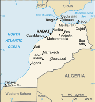
Morocco is a former French colony in northwest Africa. Since 1975, it has occupied the territory of Western Sahara, the future of which is yet to be determined by UN-supervised referendum.
Morocco is mountainous northern coast (Rif Mountains) and interior (Atlas Mountains) bordered by large plateaus with intermontane valleys, and fertile coastal plains.
The map above fully covers Morocco with its road routes from cities to towns, road intersections in any region, provinces, prefectures, also with free driving directions in Rabat or to the neighboring towns and countries. To look at the detailed map about a particular quarter in Rabat, please click on the area and zoom to the place you are interested in the Google maps of Morocco (MA).
Be creative, use the extras of this Google map; This is a detailed, clear, zoomable, large road map of Morocco with its administrative divisions; 11 regions (recognized); Beni Mellal-Khenifra, Casablanca-Settat, Draa-Tafilalet, Fes-Meknes, Guelmim-Oued Noun, Laayoune-Sakia al Hamra, Oriental, Marrakech-Safi, Rabat-Sale-Kenitra, Souss-Massa, Tanger-Tetouan-Al Hoceima. Note: Morocco claims the territory of Western Sahara, the political status of which is considered undetermined by the US Government; portions of the regions Guelmim-Oued Noun and Laayoune-Sakia al Hamra as claimed by Morocco lie within Western Sahara; Morocco also claims a 12th region, Dakhla-Oued ed Dahab, that falls entirely within Western Sahara.
The interactive map above is also may be used as the satellite map of Morocco, or as a reverse search map for finding an address from its GPS coordinates.
Morocco, about one-tenth larger than California, lies across the Strait of Gibraltar on the Mediterranean and looks out on the Atlantic from the northwest shoulder of Africa. Algeria is to the east and Mauritania to the south. On the Atlantic coast there is a fertile plain. The Mediterranean coast is mountainous. The Atlas Mountains, running northeastward from the south to the Algerian frontier, average 11,000 ft (3,353 m) in elevation.
Morocco (area: 446 550 sq km / 172 413,85 sq mi), where the official language is Arabic, Berber, lying in Africa and using the currency; Moroccan dirham (MAD), since 1958, set their clock to UTC 0. That means they are 5 hours ahead of Washington DC during Standard Time in Rabat, the capital. Note to the time difference: Daylight saving time: +1 hr begins last Sunday in April; ends last Sunday in September.
The climate in Morocco;
Geography in a nutshell;
Click here for more detailed information about Morocco.
Driving directions Morocco
The Google maps and Google Satellite maps of Morocco above showing the country, located next to Algeria, Spain. For your further reference, the latitude and longitude coordinates of Morocco are 32 00 N, 5 00 W , while the capital, Rabat found at 34 01 N 6 49 W.
When you are traveling around Morocco, Rabat, or its other cities, use this routing tool, providing up to date route planning service free of charge.
Look no further; get accurate driving directions in Morocco, Africa, by filling the route planner form below.
Since Google acquired and introduced its digitalized maps in 2004, you’re probably familiar with its base functions, like finding an address or driving directions to locations. Still, Google maps also accommodate bicyclists, pedestrians, and also public transportation with special directions and customizable routes.
About Morocco and the capital, Rabat
 |
 |
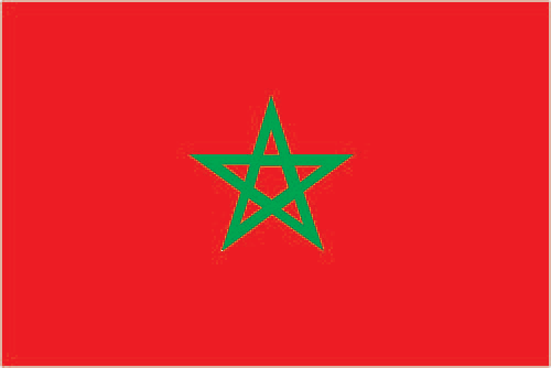
| The national flag of Morocco | Borderline map of Morocco |
| Flag description: red with a green pentacle (five-pointed, linear star) known as Sulayman’s (Solomon’s) seal in the center of the flag; red and green are traditional colors in Arab flags, although the use of red is more commonly associated with the Arab states of the Persian Gulf; the pentacle represents the five pillars of Islam and signifies the association between God and the nation; design dates to 1912. | Border length: total: 2,362.5 km. Border countries (total: 3): Algeria 1,900 km, Western Sahara 444 km, Spain (Ceuta) 8 km, Spain (Melilla) 10.5 km. Note: an additional 75-meter border segment exists between Morocco and the Spanish exclave of Penon de Velez de la Gomera. |
Did you know about Morocco?
- Morocco has been independent since 1956, becoming a kingdom in 1957. The state has occupied Western Sahara since 1975.
- The Kingdom of Morocco is famous for its historic towns, such as Fez and Marrakech, and their bustling souks, or markets.
Facts of Morocco (MA)
Name conventional long form: Kingdom of Morocco, conventional short form: Morocco, local long form: Al Mamlakah al Maghribiyah, local short form: Al Maghrib. Note: the English name “Morocco” derives from, respectively, the Spanish and Portuguese names “Marruecos” and “Marrocos,” which stem from “Marrakesh” the Latin name for the former capital of ancient Morocco; the Arabic name “Al Maghrib” translates as “The West”
Codes: ISO; MA, Internet; .ma
Capital city: Rabat
Language(s): Arabic (official language), Berber languages (Tamazight (official language), Tachelhit, Tarifit), French (often the language of business, government, and diplomacy)
National holiday(s): Throne Day (accession of King MOHAMMED VI to the throne), 30 July (1999)
Motto: Allah, al-Watan, al-Malik (God, Homeland, King)
Currency: Moroccan dirham (MAD), since 1958
GPS: 32 00 N, 5 00 W, Rabat; 34 01 N 6 49 W
Location: Northern Africa, bordering the North Atlantic Ocean and the Mediterranean Sea, between Algeria and Western Sahara
Geography note: strategic location along Strait of Gibraltar; the only African nation to have both Atlantic and Mediterranean coastlines
Land boundaries: Algeria 1,900 km, Western Sahara 444 km, Spain (Ceuta) 8 km, Spain (Melilla) 10.5 km. Note: an additional 75-meter border segment exists between Morocco and the Spanish exclave of Penon de Velez de la Gomera, total: 2,362.5 km
Maritime boundaries: N/A
Coastline: 1,835 km
Area: total: 446,550 sq km; land: 446,300 sq km, water: 250 sq km (total 172 413,85 mi2), slightly more than three times the size of New York; slightly larger than California.
Roadways: total: 58,395 km, paved: 41,116 km (includes 1,080 km of expressways), unpaved: 17,279 km (2010)
Waterways: N/A
Local time (capital): UTC 0, 5 hours ahead of Washington DC during Standard Time
Note to the local time: Daylight saving time: +1 hr begins last Sunday in April; ends last Sunday in September
Population in Morocco: 36 191 805
Population in Rabat: 1 636 600 (including the metropolitan areas)
Urbanization: urban population: 60.2% of total population (2015)
Major urban areas population: Casablanca 3.515 million; RABAT (capital) 1.967 million; Fes 1.172 million; Marrakech 1.134 million; Tangier 982,000 (2015)
Population growth rate: 0.99% (2016 estimate)
Birth rate: 18 births / 1,000 population (2016 estimate)
Death rate: 4.8 deaths / 1,000 population (2016 estimate)
Age structure: 0-14 years: 26.08% (male 4,459,511 / female 4,319,538) 15-24 years: 17.22% (male 2,882,145 / female 2,913,917) 25-54 years: 42.24% (male 6,874,144 / female 7,341,892) 55-64 years: 7.89% (male 1,318,302 / female 1,337,192) 65 years and over: 6.56% (male 995,620 / female 1,213,525) (2016 estimate)
Median age: total: 28.9 years; male: 28.3 years, female: 29.5 years (2016 estimate)
Ethnic groups: Arab-Berber 99%, other 1%
Religions: Muslim 99% (official; virtually all Sunni,
Government type: Unitary parliamentary constitutional monarchy
Legal system: mixed legal system of civil law based on French law and Islamic law; judicial review of legislative acts by Constitutional Court
National anthem: An-Naschid asch-Scharif (Cherifian Anthem)
Known national hazards: northern mountains geologically unstable and subject to earthquakes; periodic droughts
Major infectious diseases: N/A
Land use: agricultural land: 67.5%; arable land 17.5%; permanent crops 2.9%; permanent pasture 47.1%; forest: 11.5%; other: 21% (2011 estimate)
Agricultural products: barley, wheat, citrus fruits, grapes, vegetables, olives; livestock; wine
Industries: automotive parts, phosphate mining and processing, aerospace, food processing, leather goods, textiles, construction, energy, tourism
Export commodities: clothing and textiles, automobiles, electric components, inorganic chemicals, transistors, crude minerals, fertilizers (including phosphates), petroleum products, citrus fruits, vegetables, fish
Main export partners: Spain 22.1%, France 19.7%, India 4.9%, US 4.3%, Italy 4.3% (2015)
Import commodities: crude petroleum, textile fabric, telecommunications equipment, wheat, gas and electricity, transistors, plastics
Main import partners: Spain 13.9%, France 12.4%, China 8.5%, US 6.5%, Germany 5.8%, Italy 5.5%, Russia 4.4%, Turkey 4.3% (2015)
Navigate the countries in Africa faster and easier while driving, use the interactive Google maps for your driving directions. The continuously updated database contains over 220 countries and territories digitally mapped, hundreds of millions of businesses and places around the world positioned on the map.
Get fresh GPS navigation, traffic, and transit information – no matter what part of Morocco, Rabat, any other city and country in Africa, or the world you’re in.
Do you like this Morocco information page? Please don’t forget to share it with others! Thank you.