Gambia Google maps and Driving Directions
Get free driving directions, Google maps, traffic information for Gambia, and Banjul (GPS: 13 27 N 16 34 W), the capital city of the country located in (the) Western Africa, bordering the North Atlantic Ocean and Senegal.
Find any address in Banjul on the Google map of Gambia (GM) with ease or calculate your up to date itinerary to and from Gambia or its neighboring counties like Senegal.
Sightseeing and exploring in Africa starts here, thanks to Google because its Earth Engine combines a multi-petabyte catalog of updated satellite imagery and geospatial datasets with planetary-scale analysis capabilities. Wonder the world, use the satellite map function of the Google maps to explore or see differences on the Earth’s surface, inland, or the surrounding areas of Gambia.
Google Maps Gambia
Gambia is a riverbank state on the west coast of Africa, almost entirely surrounded by Senegal. It was renowned for its stability until its government was overthrown in a coup in 1994.
Gambia is flood plain of the Gambia River flanked by some low hills.
The map above fully covers Gambia with its road routes from cities to towns, road intersections in any region, provinces, prefectures, also with free driving directions in Banjul or to the neighboring towns and countries. To look at the detailed map about a particular quarter in Banjul, please click on the area and zoom to the place you are interested in the Google maps of Gambia (GM).
Be creative, use the extras of this Google map; This is a detailed, clear, zoomable, large road map of Gambia with its administrative divisions; 5 regions, 1 city*, and 1 municipality**; Banjul*, Central River, Kanifing**, Lower River, North Bank, Upper River, West Coast.
The interactive map above is also may be used as the satellite map of Gambia, or as a reverse search map for finding an address from its GPS coordinates.
Situated on the Atlantic coast in westernmost Africa and surrounded on three sides by Senegal, Gambia is twice the size of Delaware. The Gambia River flows for 200 mi (322 km) through Gambia on its way to the Atlantic. The country, the smallest on the continent, averages only 20 mi (32 km) in width.
Gambia (area: 11 295 sq km / 4 361,02 sq mi), where the official language is English, lying in Africa and using the currency; Gambian dalasi (GMD), since 1971, set their clock to UTC 0. That means they are 5 hours ahead of Washington DC during Standard Time in Banjul, the capital. Note to the time difference: N/A.
The climate in Gambia; Subtropical, with wet, humid months JulyOctober, and warm, dry season NovemberMay.
Geography in a nutshell; Located on the narrow strip of land bordering the Gambia River. Long, sandy beaches are backed by mangrove swamps along the river. Savanna and tropical forests higher up.
Click here for more detailed information about Gambia.
Driving directions Gambia
The Google maps and Google Satellite maps of Gambia above showing the country, located next to Senegal. For your further reference, the latitude and longitude coordinates of Gambia are 13 28 N, 16 34 W , while the capital, Banjul found at 13 27 N 16 34 W.
When you are traveling around Gambia, Banjul, or its other cities, use this routing tool, providing up to date route planning service free of charge.
Look no further; get accurate driving directions in Gambia, Africa, by filling the route planner form below.
Since Google acquired and introduced its digitalized maps in 2004, you’re probably familiar with its base functions, like finding an address or driving directions to locations. Still, Google maps also accommodate bicyclists, pedestrians, and also public transportation with special directions and customizable routes.
About Gambia and the capital, Banjul
 |
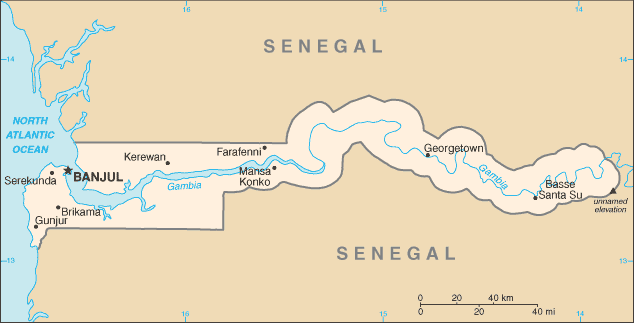 |
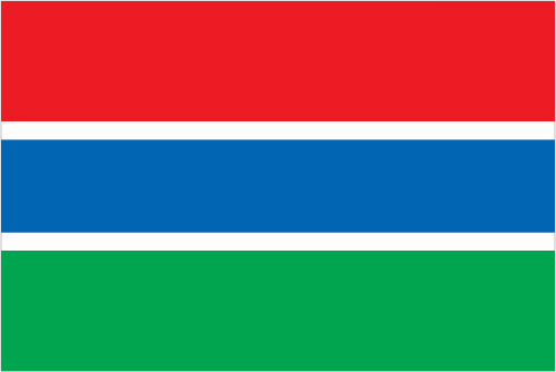
| The national flag of Gambia | Borderline map of Gambia |
| Flag description: three equal horizontal bands of red (top), blue with white edges, and green; red stands for the sun and the savannah, blue represents the Gambia River, and green symbolizes forests and agriculture; the white stripes denote unity and peace. | Border length: total: 749 km. Border countries (total: 1): Senegal 749 km. |
Did you know about Gambia?
- The Gambia became self-governing in 1963 and fully independent of Britain on February 18, 1965. It became a republic on April 24, 1970.
- Overfishing in the waters off Gambia and Senegal, mainly by foreign vessels, is a growing problem.
- A narrow strip of land on either side of the Gambia River, Gambia is popular with tourists.
Facts of Gambia (GM)
Name conventional long form: Republic of The Gambia, conventional short form: The Gambia, etymology: named for the Gambia River that flows through the heart of the country
Codes: ISO; GM, Internet; .gm
Capital city: Banjul
Language(s): English (official language), Mandinka, Wolof, Fula, other indigenous vernaculars
National holiday(s): Independence Day, 18 February (1965)
Motto: Progress, Peace, Prosperity
Currency: Gambian dalasi (GMD), since 1971
GPS: 13 28 N, 16 34 W, Banjul; 13 27 N 16 34 W
Location: Western Africa, bordering the North Atlantic Ocean and Senegal
Geography note: almost an enclave of Senegal; smallest country in Africa
Land boundaries: Senegal 749 km, total: 749 km
Maritime boundaries: N/A
Coastline: 80 km
Area: total: 11,300 sq km; land: 10,120 sq km, water: 1,180 sq km (total 4 361,02 mi2), slightly less than twice the size of Delaware.
Roadways: total: 3,740 km, paved: 711 km, unpaved: 3,029 km (2011)
Waterways: 390 km (on River Gambia; small oceangoing vessels can reach 190 km) (2010)
Local time (capital): UTC 0, 5 hours ahead of Washington DC during Standard Time
Note to the local time: N/A
Population in Gambia: 2 163 765
Population in Banjul: 54 700 (including the metropolitan areas)
Urbanization: urban population: 59.6% of total population (2015)
Major urban areas population: BANJUL (capital) 504,000 (2015)
Population growth rate: 2.11% (2016 estimate)
Birth rate: 30.1 births / 1,000 population (2016 estimate)
Death rate: 7.1 deaths / 1,000 population (2016 estimate)
Age structure: 0-14 years: 37.88% (male 382,215 / female 379,029) 15-24 years: 20.64% (male 204,979 / female 209,866) 25-54 years: 33.92% (male 333,875 / female 347,779) 55-64 years: 4.14% (male 39,978 / female 43,177) 65 years and over: 3.42% (male 32,011 / female 36,739) (2016 estimate)
Median age: total: 20.7 years; male: 20.4 years, female: 21 years (2016 estimate)
Ethnic groups: Mandinka/Jahanka 33.8%, Fulani/Tukulur/Lorobo 22.1%, Wollof 12.2%, Jola/Karoninka 10.9%, Serahuleh 7%, Serere 3.2%, Manjago 2.1%, Bambara 1%, Creole/Aku Marabout 0.8%, other 0.9%, non-Gambian 5.2%, no answer 0.7% (2013 estimate)
Religions: Muslim 95.7%, Christian 4.2%, none 0.1%, no answer 0.1% (2013 estimate)
Government type: Unitary presidential republic
Legal system: mixed legal system of English common law, Islamic law, and customary law
National anthem: For The Gambia Our Homeland
Known national hazards: drought (rainfall has dropped by 30% in the last 30 years)
Major infectious diseases: The degree of risk(s): very high food or waterborne diseases: bacterial and protozoal diarrhea, hepatitis A, and typhoid fever vectorborne diseases: malaria and dengue feverwater contact disease: schistosomiasisrespiratory disease: meningococcal meningitisanimal contact disease: rabies (2016)
Land use: agricultural land: 56.1%; arable land 41%; permanent crops 0.5%; permanent pasture 14.6%; forest: 43.9%; other: 0% (2011 estimate)
Agricultural products: rice, millet, sorghum, peanuts, corn, sesame, cassava (manioc, tapioca), palm kernels; cattle, sheep, goats
Industries: peanuts, fish, hides, tourism, beverages, agricultural machinery assembly, woodworking, metalworking, clothing
Export commodities: peanut products, fish, cotton lint, palm kernels
Main export partners: China 47.6%, India 27.2%, France 5.9%, UK 4.9% (2015)
Import commodities: foodstuffs, manufactures, fuel, machinery and transport equipment
Main import partners: China 34.2%, Brazil 8.1%, Senegal 6.9%, India 5.7%, Netherlands 4.8% (2015)
Navigate the countries in Africa faster and easier while driving, use the interactive Google maps for your driving directions. The continuously updated database contains over 220 countries and territories digitally mapped, hundreds of millions of businesses and places around the world positioned on the map.
Get fresh GPS navigation, traffic, and transit information – no matter what part of Gambia, Banjul, any other city and country in Africa, or the world you’re in.
Do you like this Gambia information page? Please don’t forget to share it with others! Thank you.