Azerbaijan Google maps and Driving Directions
Get free driving directions, Google maps, traffic information for Azerbaijan, and Baku (GPS: 40 23 N 49 52 E), the capital city of the country located in (the) Southwestern Asia, bordering the Caspian Sea, between Iran and Russia, with a small European portion north of the Caucasus range.
Find any address in Baku on the Google map of Azerbaijan (AZ) with ease or calculate your up to date itinerary to and from Azerbaijan or its neighboring counties like Armenia, Georgia, Iran, Russia, Turkey.
Sightseeing and exploring in Asia starts here, thanks to Google because its Earth Engine combines a multi-petabyte catalog of updated satellite imagery and geospatial datasets with planetary-scale analysis capabilities. Wonder the world, use the satellite map function of the Google maps to explore or see differences on the Earth’s surface, inland, or the surrounding areas of Azerbaijan.
Google Maps Azerbaijan
Situated on the western coast of the Caspian Sea, it was the first Soviet republic to declare independence in 1991. Territorial disputes with Armenia have dominated politics since.
Azerbaijan is large, flat Kur-Araz Ovaligi (Kura-Araks Lowland, much of it below sea level) with Great Caucasus Mountains to the north, Qarabag Yaylasi (Karabakh Upland) to the west; Baku lies on Abseron Yasaqligi (Apsheron Peninsula) that juts into Caspian Sea.
The map above fully covers Azerbaijan with its road routes from cities to towns, road intersections in any region, provinces, prefectures, also with free driving directions in Baku or to the neighboring towns and countries. To look at the detailed map about a particular quarter in Baku, please click on the area and zoom to the place you are interested in the Google maps of Azerbaijan (AZ).
Be creative, use the extras of this Google map; This is a detailed, clear, zoomable, large road map of Azerbaijan with its administrative divisions; 66 rayons (rayonlar; rayon – singular), 11 cities (saharlar; sahar – singular);rayons: Abseron, Agcabadi, Agdam, Agdas, Agstafa, Agsu, Astara, Babak, Balakan, Barda, Beylaqan, Bilasuvar, Cabrayil, Calilabad, Culfa, Daskasan, Fuzuli, Gadabay, Goranboy, Goycay, Goygol, Haciqabul, Imisli, Ismayilli, Kalbacar, Kangarli, Kurdamir, Lacin, Lankaran, Lerik, Masalli, Neftcala, Oguz, Ordubad, Qabala, Qax, Qazax, Qobustan, Quba, Qubadli, Qusar, Saatli, Sabirabad, Sabran, Sadarak, Sahbuz, Saki, Salyan, Samaxi, Samkir, Samux, Sarur, Siyazan, Susa, Tartar, Tovuz, Ucar, Xacmaz, Xizi, Xocali, Xocavand, Yardimli, Yevlax, Zangilan, Zaqatala, Zardabcities: Baku, Ganca, Lankaran, Mingacevir, Naftalan, Naxcivan (Nakhichevan), Saki, Sirvan, Sumqayit, Xankandi, Yevlax.
The interactive map above is also may be used as the satellite map of Azerbaijan, or as a reverse search map for finding an address from its GPS coordinates.
Azerbaijan is located on the western shore of the Caspian Sea at the southeast extremity of the Caucasus. The region is a mountainous country, and only about 7% of it is arable land. The Kura River Valley is the area’s major agricultural zone.
Azerbaijan (area: 86 600 sq km / 33 436,43 sq mi), where the official language is Azerbaijani, lying in Asia and using the currency; Azerbaijani manat (AZN), since 1992, set their clock to UTC+4. That means they are 9 hours ahead of Washington DC during Standard Time in Baku, the capital. Note to the time difference: N/A.
The climate in Azerbaijan; Low rainfall. Continental, with bitter winters, inland. Subtropical in coastal regions.
Geography in a nutshell; Caucasus Mountains in west, including Naxçivan exclave south of Armenia. Flat, low-lying terrain on the coast of the Caspian Sea.
Click here for more detailed information about Azerbaijan.
Driving directions Azerbaijan
The Google maps and Google Satellite maps of Azerbaijan above showing the country, located next to Armenia, Georgia, Iran, Russia, Turkey. For your further reference, the latitude and longitude coordinates of Azerbaijan are 40 30 N, 47 30 E , while the capital, Baku found at 40 23 N 49 52 E.
When you are traveling around Azerbaijan, Baku, or its other cities, use this routing tool, providing up to date route planning service free of charge.
Look no further; get accurate driving directions in Azerbaijan, Asia, by filling the route planner form below.
Since Google acquired and introduced its digitalized maps in 2004, you’re probably familiar with its base functions, like finding an address or driving directions to locations. Still, Google maps also accommodate bicyclists, pedestrians, and also public transportation with special directions and customizable routes.
About Azerbaijan and the capital, Baku
 |
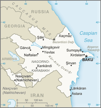 |
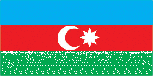
| The national flag of Azerbaijan | Borderline map of Azerbaijan |
| Flag description: three equal horizontal bands of blue (top), red, and green; a crescent and eight-pointed star in white are centered in the red band; the blue band recalls Azerbaijan’s Turkic heritage, red stands for modernization and progress, and green refers to Islam; the crescent moon and star are a Turkic insignia; the eight star points represent the eight Turkic peoples of the world. | Border length: total: 2,468 km. Border countries (total: 5): Armenia 996 km, Georgia 428 km, Iran 689 km, Russia 338 km, Turkey 17 km. |
Did you know about Azerbaijan?
- Azerbaijan has been under consecutive Persian, Ottoman, and Russian influence. It was part of the USSR from 1920, until independence in 1991.
- The fire-worshipping Zoroastrian faith originated in Azerbaijan in the 6th century BCE.
- Meaning “land of the flames after the 8th-century Persians saw burning natural gas escaping from the ground, Azerbaijan exports much oil and natural gas to Europe.
Facts of Azerbaijan (AZ)
Name conventional long form: Republic of Azerbaijan, conventional short form: Azerbaijan, local long form: Azarbaycan Respublikasi, local short form: Azarbaycan, former: Azerbaijan Soviet Socialist Republic, etymology: the name translates as “Land of fire” and refers to naturally occurring surface fires on ancient oil pools or from natural gas discharges
Codes: ISO; AZ, Internet; .az
Capital city: Baku
Language(s): Azerbaijani (Azeri) (official language) 92.5%, Russian 1.4%, Armenian 1.4%, other 4.7% (2009 estimate)
National holiday(s): Founding of the Democratic Republic of Azerbaijan, 28 May (1918)
Motto: N/A
Currency: Azerbaijani manat (AZN), since 1992
GPS: 40 30 N, 47 30 E, Baku; 40 23 N 49 52 E
Location: Southwestern Asia, bordering the Caspian Sea, between Iran and Russia, with a small European portion north of the Caucasus range
Geography note: both the main area of the country and the Naxcivan exclave are landlocked
Land boundaries: Armenia 996 km, Georgia 428 km, Iran 689 km, Russia 338 km, Turkey 17 km, total: 2,468 km
Maritime boundaries: Caspian Sea
Coastline: 0 km (landlocked country); note – Azerbaijan borders the Caspian Sea (713 km)
Area: total: 86,600 sq km; land: 82,629 sq km, water: 3,971 sq km (total 33 436,43 mi2), slightly smaller than Maine.
Roadways: total: 52,942 km, paved: 26,789 km, unpaved: 26,153 km (2006)
Waterways: N/A
Local time (capital): UTC+4, 9 hours ahead of Washington DC during Standard Time
Note to the local time: N/A
Population in Azerbaijan: 9 923 914
Population in Baku: 2 118 600 (including the metropolitan areas)
Urbanization: urban population: 54.6% of total population (2015)
Major urban areas population: BAKU (capital) 2.374 million (2015)
Population growth rate: 0.92% (2016 estimate)
Birth rate: 16.2 births / 1,000 population (2016 estimate)
Death rate: 7.1 deaths / 1,000 population (2016 estimate)
Age structure: 0-14 years: 22.82% (male 1,204,976 / female 1,047,737) 15-24 years: 15.77% (male 812,537 / female 744,538) 25-54 years: 45.28% (male 2,188,683 / female 2,281,242) 55-64 years: 9.64% (male 439,566 / female 512,118) 65 years and over: 6.5% (male 245,144 / female 396,224) (2016 estimate)
Median age: total: 30.9 years; male: 29.3 years, female: 32.6 years (2016 estimate)
Ethnic groups: Azerbaijani 91.6%, Lezghin 2%, Russian 1.3%, Armenian 1.3%, Talysh 1.3%, other 2.4%note: the separatist Nagorno-Karabakh region is populated almost entirely by ethnic Armenians (2009 estimate)
Religions: Muslim 96.9% (predominantly Shia), Christian 3%, other
Government type: Unitary dominant-party semi-presidential republic
Legal system: civil law system
National anthem: March of Azerbaijan
Known national hazards: droughts
Major infectious diseases: N/A
Land use: agricultural land: 57.6%; arable land 22.8%; permanent crops 2.7%; permanent pasture 32.1%; forest: 11.3%; other: 31.1% (2011 estimate)
Agricultural products: fruit, vegetables, grain, rice, grapes, tea, cotton, tobacco; cattle, pigs, sheep, goats
Industries: petroleum and petroleum products, natural gas, oilfield equipment; steel, iron ore; cement; chemicals and petrochemicals; textiles
Export commodities: oil and gas 90%, machinery, foodstuffs, cotton
Main export partners: Italy 26.3%, Germany 13.3%, Indonesia 7%, France 6.9%, Czech Republic 6% (2015)
Import commodities: machinery and equipment, foodstuffs, metals, chemicals
Main import partners: Russia 19.9%, Turkey 16.5%, UK 8.6%, Germany 6.6%, Italy 6.3%, US 4.1% (2015)
Navigate the countries in Asia faster and easier while driving, use the interactive Google maps for your driving directions. The continuously updated database contains over 220 countries and territories digitally mapped, hundreds of millions of businesses and places around the world positioned on the map.
Get fresh GPS navigation, traffic, and transit information – no matter what part of Azerbaijan, Baku, any other city and country in Asia, or the world you’re in.
Do you like this Azerbaijan information page? Please don’t forget to share it with others! Thank you.