Armenia Google maps and Driving Directions
Get free driving directions, Google maps, traffic information for Armenia, and Yerevan (GPS: 40 10 N 44 30 E), the capital city of the country located in (the) Southwestern Asia, between Turkey (to the west) and Azerbaijan; note – Armenia views itself as part of Europe; geopolitically, it can be classified as falling within Europe, the Middle East, or both.
Find any address in Yerevan on the Google map of Armenia (AM) with ease or calculate your up to date itinerary to and from Armenia or its neighboring counties like Azerbaijan, Georgia, Iran, Turkey.
Sightseeing and exploring in Asia starts here, thanks to Google because its Earth Engine combines a multi-petabyte catalog of updated satellite imagery and geospatial datasets with planetary-scale analysis capabilities. Wonder the world, use the satellite map function of the Google maps to explore or see differences on the Earth’s surface, inland, or the surrounding areas of Armenia.
Google Maps Armenia
The smallest of the former USSRs republics, Armenia lies landlocked in the Lesser Caucasus Mountains. After 1988, a confrontation with Azerbaijan dominated national life.
Armenia is Armenian Highland with mountains; little forest land; fast flowing rivers; good soil in Aras River valley.
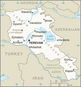
The map above fully covers Armenia with its road routes from cities to towns, road intersections in any region, provinces, prefectures, also with free driving directions in Yerevan or to the neighboring towns and countries. To look at the detailed map about a particular quarter in Yerevan, please click on the area and zoom to the place you are interested in the Google maps of Armenia (AM).
Be creative, use the extras of this Google map; This is a detailed, clear, zoomable, large road map of Armenia with its administrative divisions; 11 provinces (marzer, singular – marz); Aragatsotn, Ararat, Armavir, Geghark’unik’, Kotayk’, Lorri, Shirak, Syunik’, Tavush, Vayots’ Dzor, Yerevan.
The interactive map above is also may be used as the satellite map of Armenia, or as a reverse search map for finding an address from its GPS coordinates.
Armenia is located in the southern Caucasus and is the smallest of the former Soviet republics. It is bounded by Georgia on the north, Azerbaijan on the east, Iran on the south, and Turkey on the west. Contemporary Armenia is a fraction of the size of ancient Armenia. A land of rugged mountains and extinct volcanoes, its highest point is Mount Aragats, 13,435 ft (4,095 m).
Armenia (area: 29 743 sq km / 11 483,83 sq mi), where the official language is Armenian, lying in Asia and using the currency; Armenian dram (AMD), since 1993, set their clock to UTC+4. That means they are 9 hours ahead of Washington DC during Standard Time in Yerevan, the capital. Note to the time difference: N/A.
The climate in Armenia; Continental climate, with little rainfall in the lowlands. The winters are often bitterly cold.
Geography in a nutshell; Rugged and mountainous, with expanses of semidesert and a large lake in the east: Sevana Lich.
Click here for more detailed information about Armenia.
Driving directions Armenia
The Google maps and Google Satellite maps of Armenia above showing the country, located next to Azerbaijan, Georgia, Iran, Turkey. For your further reference, the latitude and longitude coordinates of Armenia are 40 00 N, 45 00 E , while the capital, Yerevan found at 40 10 N 44 30 E.
When you are traveling around Armenia, Yerevan, or its other cities, use this routing tool, providing up to date route planning service free of charge.
Look no further; get accurate driving directions in Armenia, Asia, by filling the route planner form below.
Since Google acquired and introduced its digitalized maps in 2004, you’re probably familiar with its base functions, like finding an address or driving directions to locations. Still, Google maps also accommodate bicyclists, pedestrians, and also public transportation with special directions and customizable routes.
About Armenia and the capital, Yerevan
 |
 |
| The national flag of Armenia | Borderline map of Armenia |
| Flag description: three equal horizontal bands of red (top), blue, and orange; the color red recalls the bloodshed for liberty, blue the Armenian skies as well as hope, and orange the land and the courage of the workers who farm it. | Border length: total: 1,570 km. Border countries (total: 4): Azerbaijan 996 km, Georgia 219 km, Iran 44 km, Turkey 311 km. |
Did you know about Armenia?
- Armenia became a Soviet republic in 1922. In 1991 it gained independence from the USSR and in 1995 held its first parliamentary elections.
- In the 4th century, Armenia became the first country to adopt Christianity as its state religion.
- Armenia relies primarily on farming, notably sheep rearing, as its main industry.
Facts of Armenia (AM)
Name conventional long form: Republic of Armenia, conventional short form: Armenia, local long form: Hayastani Hanrapetut’yun, local short form: Hayastan, former: Armenian Soviet Socialist Republic, Armenian Republic, etymology: the , etymology of the country’s name remains obscure; according to tradition, the country named after Hayk, the legendary patriarch of the Armenians and the great-great-grandson of Noah; Hayk’s descendant, Aram, purportedly is the source of the name Armenia
Codes: ISO; AM, Internet; .am
Capital city: Yerevan
Language(s): Armenian (official language) 97.9%, Kurdish (spoken by Yezidi minority) 1%, other 1% (2011 estimate)
National holiday(s): Independence Day, 21 September (1991)
Motto: N/A
Currency: Armenian dram (AMD), since 1993
GPS: 40 00 N, 45 00 E, Yerevan; 40 10 N 44 30 E
Location: Southwestern Asia, between Turkey (to the west) and Azerbaijan; note – Armenia views itself as part of Europe; geopolitically, it can be classified as falling within Europe, the Middle East, or both
Geography note: landlocked in the Lesser Caucasus Mountains; Sevana Lich (Lake Sevan) is the largest lake in this mountain range
Land boundaries: Azerbaijan 996 km, Georgia 219 km, Iran 44 km, Turkey 311 km, total: 1,570 km
Maritime boundaries: N/A
Coastline: 0 km (landlocked country)
Area: total: 29,743 sq km; land: 28,203 sq km, water: 1,540 sq km (total 11 483,83 mi2), slightly smaller than Maryland.
Roadways: total: 7,792 km (2013)
Waterways: N/A
Local time (capital): UTC+4, 9 hours ahead of Washington DC during Standard Time
Note to the local time: N/A
Population in Armenia: 2 934 152
Population in Yerevan: 1 462 700 (including the metropolitan areas)
Urbanization: urban population: 62.7% of total population (2015)
Major urban areas population: YEREVAN (capital) 1,044 (2015)
Population growth rate: -0.18% (2016 estimate)
Birth rate: 13.3 births / 1,000 population (2016 estimate)
Death rate: 9.4 deaths / 1,000 population (2016 estimate)
Age structure: 0-14 years: 19% (male 308,701 / female 271,028) 15-24 years: 13.58% (male 213,203 / female 201,291) 25-54 years: 43.46% (male 640,070 / female 685,958) 55-64 years: 12.96% (male 180,700 / female 214,834) 65 years and over: 10.99% (male 134,330 / female 201,135) (2016 estimate)
Median age: total: 34.6 years; male: 32.8 years, female: 36.5 years (2016 estimate)
Ethnic groups: Armenian 98.1%, Yezidi (Kurd) 1.1%, other 0.7% (2011 estimate)
Religions: Armenian Apostolic 92.6%, Evangelical 1%, other 2.4%, none 1.1%, unspecified 2.9% (2011 estimate)
Government type: Unitary semi-presidential republic
Legal system: civil law system
National anthem: Mer Hayrenik (Our Fatherland)
Known national hazards: occasionally severe earthquakes; droughts
Major infectious diseases: N/A
Land use: agricultural land: 59.7%; arable land 15.8%; permanent crops 1.9%; permanent pasture 42%; forest: 9.1%; other: 31.2% (2011 estimate)
Agricultural products: fruit (especially grapes), vegetables; livestock
Industries: diamond processing, metal-cutting machine tools, forging and pressing machines, electric motors, knitted wear, hosiery, shoes, silk fabric, chemicals, trucks, instruments, microelectronics, jewelry, software, food processing, brandy, mining
Export commodities: pig iron, unwrought copper, nonferrous metals, gold, diamonds, mineral products, foodstuffs, energy
Main export partners: Russia 15.2%, China 11.1%, Germany 9.8%, Iraq 8.8%, Georgia 7.8%, Canada 7.6%, Bulgaria 5.3%, Iran 5.3% (2015)
Import commodities: natural gas, petroleum, tobacco products, foodstuffs, diamonds, pharmaceuticals, cars
Main import partners: Russia 29.1%, China 9.7%, Germany 6.2%, Iran 6.1%, Italy 4.6%, Turkey 4.2% (2015)
Navigate the countries in Asia faster and easier while driving, use the interactive Google maps for your driving directions. The continuously updated database contains over 220 countries and territories digitally mapped, hundreds of millions of businesses and places around the world positioned on the map.
Get fresh GPS navigation, traffic, and transit information – no matter what part of Armenia, Yerevan, any other city and country in Asia, or the world you’re in.
Do you like this Armenia information page? Please don’t forget to share it with others! Thank you.