East Timor Google maps and Driving Directions
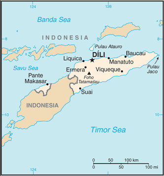
Get free driving directions, Google maps, traffic information for East Timor, and Dili (GPS: 8 35 S 125 36 E), the capital city of the country located in (the) Southeastern Asia, northwest of Australia in the Lesser Sunda Islands at the eastern end of the Indonesian archipelago; note – Timor-Leste includes the eastern half of the island of Timor, the Oecussi (Ambeno) region on the northwest portion of the island of Timor, and the islands of Pulau Atauro and Pulau Jaco.
Find any address in Dili on the Google map of East Timor (TL) with ease or calculate your up to date itinerary to and from East Timor or its neighboring counties like Indonesia.
Sightseeing and exploring in Oceania starts here, thanks to Google because its Earth Engine combines a multi-petabyte catalog of updated satellite imagery and geospatial datasets with planetary-scale analysis capabilities. Wonder the world, use the satellite map function of the Google maps to explore or see differences on the Earth’s surface, inland, or the surrounding areas of East Timor.
Google Maps East Timor
East Timor occupies the once Portuguese-owned eastern half of the island of Timor. Invaded by Indonesia in 1975, it became independent in 2002 following a long struggle.
East Timor is mountainous.
The map above fully covers East Timor with its road routes from cities to towns, road intersections in any region, provinces, prefectures, also with free driving directions in Dili or to the neighboring towns and countries. To look at the detailed map about a particular quarter in Dili, please click on the area and zoom to the place you are interested in the Google maps of East Timor (TL).
Be creative, use the extras of this Google map; This is a detailed, clear, zoomable, large road map of East Timor with its administrative divisions; 13 administrative districts; Aileu, Ainaro, Baucau, Bobonaro (Maliana), Cova-Lima (Suai), Dili, Ermera (Gleno), Lautem (Los Palos), Liquica, Manatuto, Manufahi (Same), Oecussi (Ambeno), Viqueque. Note: administrative divisions have the same names as their administrative centers (exceptions have the administrative center name following in parentheses).
The interactive map above is also may be used as the satellite map of East Timor, or as a reverse search map for finding an address from its GPS coordinates.
East Timor is located in the eastern part of Timor, an island in the Indonesian archipelago that lies between the South China Sea and the Indian Ocean. East Timor includes the enclave of Oecussi, which is located within West Timor (Indonesia). After Indonesia, East Timor’s closest neighbor is Australia, 400 mi to the south. It is semiarid and mountainous.
East Timor (area: 14 874 sq km / 5 742,88 sq mi), where the official language is Portuguese, Tetum, lying in Oceania and using the currency; United States dollar (USD), set their clock to UTC+9. That means they are 14 hours ahead of Washington DC during Standard Time in Dili, the capital. Note to the time difference: N/A.
The climate in East Timor; Tropical. Heavy rain in wet season (DecemberMarch), then dry and hot, particularly in the north.
Geography in a nutshell; A narrow coastal plain gives way to forested highlands. The mountain backbone rises to 9715 ft (2963 m).
Click here for more detailed information about East Timor.
Driving directions East Timor
The Google maps and Google Satellite maps of East Timor above showing the country, located next to Indonesia. For your further reference, the latitude and longitude coordinates of East Timor are 8 50 S, 125 55 E , while the capital, Dili found at 8 35 S 125 36 E.
When you are traveling around East Timor, Dili, or its other cities, use this routing tool, providing up to date route planning service free of charge.
Look no further; get accurate driving directions in East Timor, Southeast Asia, by filling the route planner form below.
[xyz-ihs snippet=”routing”]
Since Google acquired and introduced its digitalized maps in 2004, you’re probably familiar with its base functions, like finding an address or driving directions to locations. Still, Google maps also accommodate bicyclists, pedestrians, and also public transportation with special directions and customizable routes.
About East Timor and the capital, Dili
 |
 |
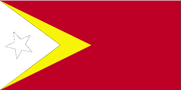
| The national flag of East Timor | Borderline map of East Timor |
| Flag description: red with a black isosceles triangle (based on the hoist side) superimposed on a slightly longer yellow arrowhead that extends to the center of the flag; a white star – pointing to the upper hoist-side corner of the flag – is in the center of the black triangle; yellow denotes the colonialism in Timor-Leste’s past; black represents the obscurantism that needs to be overcome; red stands for the national liberation struggle; the white star symbolizes peace and serves as a guiding light. | Border length: total: 253 km. Border countries (total: 1): Indonesia 253 km. |
Did you know about East Timor?
- East Timor voted for independence from Indonesia in 1999. A UN administration was in place until official independence on May 20, 2002.
- Once dependent on sandalwood, the economy is being transformed by oil under the Timor Sea.
- The waters off this tiny nation contain one of the richest oil fields in the world outside the Middle East.
Facts of East Timor (TL)
Name conventional long form: Democratic Republic of Timor-Leste, conventional short form: Timor-Leste. Note: pronounced TEE-mor LESS-tay, local long form: Republika Demokratika Timor Lorosa’e [Tetum]; Republica Democratica de Timor-Leste [Portuguese], local short form: Timor Lorosa’e [Tetum]; Timor-Leste [Portuguese], former: East Timor, Portuguese Timor, etymology: “timor” derives from the Indonesian and Malay word “timur” meaning “east”; “leste” is the Portuguese word for “east”, so “Timor-Leste” literally means “Eastern-East”; the local [Tetum] name “Timor Lorosa’e” translates as “East Rising Sun”
Codes: ISO; TL, Internet; .tl
Capital city: Dili
Language(s): Tetum (official language), Portuguese (official language), Indonesian, English. Note: there are about 16 indigenous languages; Tetum, Galole, Mambae, and Kemak are spoken by a significant portion of the population
National holiday(s): Restoration of Independence Day, 20 May (2002); Proclamation of Independence Day, 28 November (1975)
Motto: Unidade, Acçao, Progresso (Unity, Action, Progress)
Currency: United States dollar (USD)
GPS: 8 50 S, 125 55 E, Dili; 8 35 S 125 36 E
Location: Southeastern Asia, northwest of Australia in the Lesser Sunda Islands at the eastern end of the Indonesian archipelago; note – Timor-Leste includes the eastern half of the island of Timor, the Oecussi (Ambeno) region on the northwest portion of the island of Timor, and the islands of Pulau Atauro and Pulau Jaco
Geography note: Timor comes from the Malay word for “east”; the island of Timor is part of the Malay Archipelago and is the largest and easternmost of the Lesser Sunda Islands
Land boundaries: Indonesia 253 km, total: 253 km
Maritime boundaries: N/A
Coastline: 706 km
Area: total: 14,874 sq km; land: 14,874 sq km, water: 0 sq km (total 5 742,88 mi2), slightly larger than Connecticut.
Roadways: total: 6,040 km, paved: 2,600 km, unpaved: 3,440 km (2005)
Waterways: N/A
Local time (capital): UTC+9, 14 hours ahead of Washington DC during Standard Time
Note to the local time: N/A
Population in East Timor: 1 324 094
Population in Dili: 50 800 (including the metropolitan areas)
Urbanization: urban population: 32.8% of total population (2015)
Major urban areas population: DILI (capital) 228,000 (2014)
Population growth rate: 2.39% (2016 estimate)
Birth rate: 33.8 births / 1,000 population (2016 estimate)
Death rate: 6 deaths / 1,000 population (2016 estimate)
Age structure: 0-14 years: 41.43% (male 268,578 / female 253,897) 15-24 years: 20.11% (male 128,678 / female 124,870) 25-54 years: 29.79% (male 180,750 / female 194,916) 55-64 years: 4.88% (male 31,349 / female 30,194) 65 years and over: 3.79% (male 22,852 / female 24,988) (2016 estimate)
Median age: total: 18.8 years; male: 18.2 years, female: 19.4 years (2016 estimate)
Ethnic groups: Austronesian (Malayo-Polynesian), Papuan, small Chinese minority
Religions: Roman Catholic 96.9%, Protestant/Evangelical 2.2%, Muslim 0.3%, other 0.6% (2005)
Government type: Unitary semi-presidential republic
Legal system: civil law system based on the Portuguese model; note – penal and civil law codes to replace the Indonesian codes were passed by Parliament and promulgated in 2009 and 2011, respectively
National anthem: Pátria (Fatherland)
Known national hazards: floods and landslides are common; earthquakes; tsunamis; tropical cyclones
Major infectious diseases: The degree of risk(s): very high food or waterborne diseases: bacterial diarrhea, hepatitis A, and typhoid fever vectorborne diseases: dengue fever and malaria (2016)
Land use: agricultural land: 25.1%; arable land 10.1%; permanent crops 4.9%; permanent pasture 10.1%; forest: 49.1%; other: 25.8% (2011 estimate)
Agricultural products: coffee, rice, corn, cassava (manioc, tapioca), sweet potatoes, soybeans, cabbage, mangoes, bananas, vanilla
Industries: printing, soap manufacturing, handicrafts, woven cloth
Export commodities: oil, coffee, sandalwood, marble. Note: potential for vanilla exports
Main export partners: N/A
Import commodities: food, gasoline, kerosene, machinery
Main import partners: N/A
Navigate the countries in Southeast Asia faster and easier while driving, use the interactive Google maps for your driving directions. The continuously updated database contains over 220 countries and territories digitally mapped, hundreds of millions of businesses and places around the world positioned on the map.
Get fresh GPS navigation, traffic, and transit information – no matter what part of East Timor, Dili, any other city and country in Oceania, or the world you’re in.
Do you like this East Timor information page? Please don’t forget to share it with others! Thank you.