Benin Google maps and Driving Directions
Get free driving directions, Google maps, traffic information for Benin, and Porto Novo (GPS: 6 29 N 2 37 E), the capital city of the country located in (the) Western Africa, bordering the Bight of Benin, between Nigeria and Togo.
Find any address in Porto Novo on the Google map of Benin (BN) with ease or calculate your up to date itinerary to and from Benin or its neighboring counties like Burkina Faso, Niger, Nigeria, Togo.
Sightseeing and exploring in Africa starts here, thanks to Google because its Earth Engine combines a multi-petabyte catalog of updated satellite imagery and geospatial datasets with planetary-scale analysis capabilities. Wonder the world, use the satellite map function of the Google maps to explore or see differences on the Earth’s surface, inland, or the surrounding areas of Benin.
Google Maps Benin
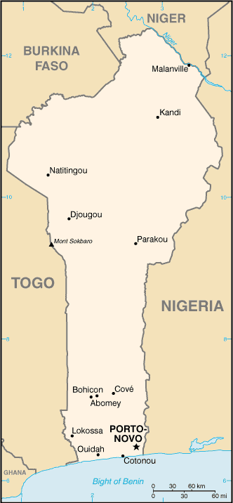
Benin stretches north from the west African coast. In 1990, Benin became one of the pioneers of African democratization, ending 17 years of one-party Marxist-Leninist rule.
Benin is mostly flat to undulating plain; some hills and low mountains.
The map above fully covers Benin with its road routes from cities to towns, road intersections in any region, provinces, prefectures, also with free driving directions in Porto Novo or to the neighboring towns and countries. To look at the detailed map about a particular quarter in Porto-Novo, please click on the area and zoom to the place you are interested in the Google maps of Benin (BN).
Be creative, use the extras of this Google map; This is a detailed, clear, zoomable, large road map of Benin with its administrative divisions; 12 departments; Alibori, Atacora, Atlantique, Borgou, Collines, Couffo, Donga, Littoral, Mono, Oueme, Plateau, Zou.
The interactive map above is also may be used as the satellite map of Benin, or as a reverse search map for finding an address from its GPS coordinates.
This West African nation on the Gulf of Guinea, between Togo on the west and Nigeria on the east, is about the size of Tennessee. It is bounded by Burkina Faso and Niger on the north. The land consists of a narrow coastal strip that rises to a swampy, forested plateau and then to highlands in the north. A hot and humid climate blankets the entire country.
Benin (area: 114 763 sq km / 44 310,22 sq mi), where the official language is French, lying in Africa and using the currency; West African CFA franc (XOF), set their clock to UTC+1. That means they are 6 hours ahead of Washington DC during Standard Time in Porto-Novo, the capital. Note to the time difference: N/A.
The climate in Benin; Hot and humid in the south. Two rainy seasons. Hot, dusty harmattan winds blow during the DecemberFebruary dry season.
Geography in a nutshell; Sandy coastal region. Numerous lagoons lie just behind the shoreline. Forested plateaus inland. Mountains in the northwest.
Click here for more detailed information about Benin.
Driving directions Benin
The Google maps and Google Satellite maps of Benin above showing the country, located next to Burkina Faso, Niger, Nigeria, Togo. For your further reference, the latitude and longitude coordinates of Benin are 9 30 N, 2 15 E , while the capital, Porto-Novo found at 6 29 N 2 37 E.
When you are traveling around Benin, Porto-Novo, or its other cities, use this routing tool, providing up to date route planning service free of charge.
Look no further; get accurate driving directions in Benin, Africa, by filling the route planner form below.
Since Google acquired and introduced its digitalized maps in 2004, you’re probably familiar with its base functions, like finding an address or driving directions to locations. Still, Google maps also accommodate bicyclists, pedestrians, and also public transportation with special directions and customizable routes.
About Benin and the capital, Porto Novo
 |
 |
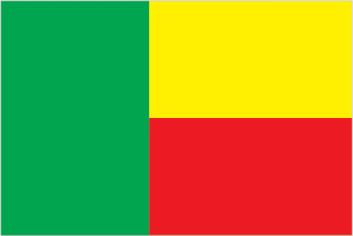
| The national flag of Benin | Borderline map of Benin |
| Flag description: two equal horizontal bands of yellow (top) and red (bottom) with a vertical green band on the hoist side; green symbolizes hope and revival, yellow wealth, and red courage. Note: uses the popular Pan-African colors of Ethiopia. | Border length: total: 2,123 km. Border countries (total: 4): Burkina Faso 386 km, Niger 277 km, Nigeria 809 km, Togo 651 km. |
Did you know about Benin?
- Originally known as Dahomey, Benin became autonomous in 1958 and independent from France in 1960. Its name was changed in 1975.
- Voodoo is thought to have originated in Benin, and was taken to Haiti by slaves.
- A mainly agricultural nation, Benins people live off the land and catch fish in its rivers or off its narrow coastline.
Facts of Benin (BN)
Name conventional long form: Republic of Benin, conventional short form: Benin, local long form: Republique du Benin, local short form: Benin, former: Dahomey, etymology: named for the Bight of Benin, the body of water on which the country lies
Codes: ISO; BN, Internet; .bj
Capital city: Porto Novo
Language(s): French (official language), Fon and Yoruba (most common vernaculars in south), tribal languages (at least six major ones in north)
National holiday(s): National Day, 1 August (1960)
Motto: Fraternité, Justice, Travail (Fraternity, Justice, Labour)
Currency: West African CFA franc (XOF)
GPS: 9 30 N, 2 15 E, Porto Novo; 6 29 N 2 37 E
Location: Western Africa, bordering the Bight of Benin, between Nigeria and Togo
Geography note: sandbanks create difficult access to a coast with no natural harbors, river mouths, or islands
Land boundaries: Burkina Faso 386 km, Niger 277 km, Nigeria 809 km, Togo 651 km, total: 2,123 km
Maritime boundaries: N/A
Coastline: 121 km
Area: total: 112,622 sq km; land: 110,622 sq km, water: 2,000 sq km (total 44 310,22 mi2), slightly smaller than Pennsylvania.
Roadways: total: 16,000 km, paved: 1,400 km, unpaved: 14,600 km (2006)
Waterways: 150 km (seasonal navigation on River Niger along northern border) (2011)
Local time (capital): UTC+1, 6 hours ahead of Washington DC during Standard Time
Note to the local time: N/A
Population in Benin: 11 485 674
Population in Porto-Novo: 231 600 (including the metropolitan areas)
Urbanization: urban population: 44% of total population (2015)
Major urban areas population: PORTO-NOVO (capital) 268,000 (2014); COTONOU (seat of government) 682,000; Abomey-Calavi 757,000 (2015)
Population growth rate: 2.75% (2016 estimate)
Birth rate: 35.5 births / 1,000 population (2016 estimate)
Death rate: 8 deaths / 1,000 population (2016 estimate)
Age structure: 0-14 years: 43.04% (male 2,358,838 / female 2,264,204) 15-24 years: 20.32% (male 1,110,607 / female 1,072,196) 25-54 years: 30.24% (male 1,641,547 / female 1,606,185) 55-64 years: 3.56% (male 165,496 / female 217,192) 65 years and over: 2.84% (male 120,629 / female 184,564) (2016 estimate)
Median age: total: 18 years; male: 17.7 years, female: 18.4 years (2016 estimate)
Ethnic groups: Fon and related 38.4%, Adja and related 15.1%, Yoruba and related 12%, Bariba and related 9.6%, Fulani and related 8.6%, Ottamari and related 6.1%, Yoa-Lokpa and related 4.3%, Dendi and related 2.9%, other 0.9%, foreigner 1.9% (2013 estimate)
Religions: Muslim 27.7%, Catholic 25.5%, Protestant 13.5% (Celestial 6.7%, Methodist 3.4%, other Protestant 3.4%), Vodoun 11.6%, other Christian 9.5%, other traditional religions 2.6%, other 2.6%, none 5.8% (2013 estimate)
Government type: Presidential republic
Legal system: civil law system modeled largely on the French system and some customary law
National anthem: L’Aube nouvelle (The Dawn of a New Day)
Known national hazards: hot, dry, dusty harmattan wind may affect north from December to March
Major infectious diseases: The degree of risk(s): very high food or waterborne diseases: bacterial and protozoal diarrhea, hepatitis A, and typhoid fever vectorborne diseases: dengue fever, malaria, and yellow feverrespiratory disease: meningococcal meningitisanimal contact disease: rabies (2016)
Land use: agricultural land: 31.3%; arable land 22.9%; permanent crops 3.5%; permanent pasture 4.9%; forest: 40%; other: 28.7% (2011 estimate)
Agricultural products: cotton, corn, cassava (manioc, tapioca), yams, beans, palm oil, peanuts, cashews; livestock
Industries: textiles, food processing, construction materials, cement
Export commodities: cotton, cashews, shea butter, textiles, palm products, seafood
Main export partners: India 24.2%, Gabon 14.6%, China 7.2%, Niger 6%, Bangladesh 5%, Nigeria 4.9%, Vietnam 4.2% (2015)
Import commodities: foodstuffs, capital goods, petroleum products
Main import partners: China 42.1%, US 8.9%, India 5.7%, Malaysia 4.8%, Thailand 4.3%, France 4% (2015)
Navigate the countries in Africa faster and easier while driving, use the interactive Google maps for your driving directions. The continuously updated database contains over 220 countries and territories digitally mapped, hundreds of millions of businesses and places around the world positioned on the map.
Get fresh GPS navigation, traffic, and transit information – no matter what part of Benin, Porto Novo, any other city and country in Africa, or the world you’re in.
Do you like this Benin information page? Please don’t forget to share it with others! Thank you.