Madagascar Google maps and Driving Directions
Get free driving directions, Google maps, traffic information for Madagascar, and Antananarivo (GPS: 18 55 S 47 31 E), the capital city of the country located in (the) Southern Africa, island in the Indian Ocean, east of Mozambique.
Find any address in Antananarivo on the Google map of Madagascar (MG) with ease or calculate your up to date itinerary to and from Madagascar or its neighboring counties like N/A.
Sightseeing and exploring in Africa starts here, thanks to Google because its Earth Engine combines a multi-petabyte catalog of updated satellite imagery and geospatial datasets with planetary-scale analysis capabilities. Wonder the world, use the satellite map function of the Google maps to explore or see differences on the Earth’s surface, inland, or the surrounding areas of Madagascar.
Google Maps Madagascar
Lying off east Africa in the Indian Ocean, the former French colony of Madagascar is the worlds fourth-largest island. Power struggles erupted onto the streets in 2002 and 2009.
Madagascar is narrow coastal plain, high plateau and mountains in center.
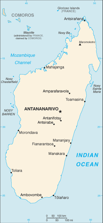
The map above fully covers Madagascar with its road routes from cities to towns, road intersections in any region, provinces, prefectures, also with free driving directions in Antananarivo or to the neighboring towns and countries. To look at the detailed map about a particular quarter in Antananarivo, please click on the area and zoom to the place you are interested in the Google maps of Madagascar (MG).
Be creative, use the extras of this Google map; This is a detailed, clear, zoomable, large road map of Madagascar with its administrative divisions; 6 provinces (faritany); Antananarivo, Antsiranana, Fianarantsoa, Mahajanga, Toamasina, Toliara.
The interactive map above is also may be used as the satellite map of Madagascar, or as a reverse search map for finding an address from its GPS coordinates.
Madagascar lies in the Indian Ocean off the southeast coast of Africa opposite Mozambique. The world’s fourth-largest island, it is twice the size of Arizona. The country’s low-lying coastal area gives way to a central plateau. The once densely wooded interior has largely been cut down.
Madagascar (area: 587 041 sq km / 226 657,70 sq mi), where the official language is French, Malagasy, lying in Africa and using the currency; Malagasy ariary (MGA), since 2003, set their clock to UTC+3. That means they are 8 hours ahead of Washington DC during Standard Time in Antananarivo, the capital. Note to the time difference: N/A.
The climate in Madagascar; Tropical and often hit by cyclones. Monsoons affect the east coast. The southwest is much drier.
Geography in a nutshell; More than two-thirds of the country forms a savanna-covered plateau, which drops in the east through rainforests to the coast.
Click here for more detailed information about Madagascar.
Driving directions Madagascar
The Google maps and Google Satellite maps of Madagascar above showing the country, located next to N/A. For your further reference, the latitude and longitude coordinates of Madagascar are 20 00 S, 47 00 E , while the capital, Antananarivo found at 18 55 S 47 31 E.
When you are traveling around Madagascar, Antananarivo, or its other cities, use this routing tool, providing up to date route planning service free of charge.
Look no further; get accurate driving directions in Madagascar, Africa, by filling the route planner form below.
Since Google acquired and introduced its digitalized maps in 2004, you’re probably familiar with its base functions, like finding an address or driving directions to locations. Still, Google maps also accommodate bicyclists, pedestrians, and also public transportation with special directions and customizable routes.
About Madagascar and the capital, Antananarivo
 |
 |
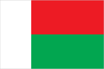
| The national flag of Madagascar | Borderline map of Madagascar |
| Flag description: two equal horizontal bands of red (top) and green with a vertical white band of the same width on hoist side; by tradition, red stands for sovereignty, green for hope, white for purity. | Border length: 0 km. |
Did you know about Madagascar?
- Madagascar annexed by France in 1895 and the monarchy abolished two years later. It achieved independence in 1960.
- 80% of Madagascars plants and many of its animal species are found nowhere else.
- The worlds fourth largest island, Madagascar is home to an unusual range of wildlife, including the lemur, which is found nowhere else in the world.
Facts of Madagascar (MG)
Name conventional long form: Republic of Madagascar, conventional short form: Madagascar, local long form: Republique de Madagascar/Repoblikan’i Madagasikara, local short form: Madagascar/Madagasikara, former: Malagasy Republic. Note: the name “Madageiscar” was first used by the 13th-century Venetian explorer Marco POLO, as a corrupted transliteration of Mogadishu, the Somali port with which POLO confused the island
Codes: ISO; MG, Internet; .mg
Capital city: Antananarivo
Language(s): French (official language), Malagasy (official language), English
National holiday(s): Independence Day, 26 June (1960)
Motto: Tanindrazana, Fahafahana, Fandrosoana (Love, Fatherland, Progress)
Currency: Malagasy ariary (MGA), since 2003
GPS: 20 00 S, 47 00 E, Antananarivo; 18 55 S 47 31 E
Location: Southern Africa, island in the Indian Ocean, east of Mozambique
Geography note: world’s fourth-largest island; strategic location along Mozambique Channel
Land boundaries: N/A, 0 km
Maritime boundaries: Indian Ocean
Coastline: 4,828 km
Area: total: 587,041 sq km; land: 581,540 sq km, water: 5,501 sq km (total 226 657,70 mi2), slightly less than twice the size of Arizona.
Roadways: total: 37,476 km, paved: 6,103 km, unpaved: 31,373 km (2010)
Waterways: 600 km (432 km navigable) (2011)
Local time (capital): UTC+3, 8 hours ahead of Washington DC during Standard Time
Note to the local time: N/A
Population in Madagascar: 26 262 810
Population in Antananarivo: 1 390 800 (including the metropolitan areas)
Urbanization: urban population: 35.1% of total population (2015)
Major urban areas population: ANTANANARIVO (capital) 2.61 million (2015)
Population growth rate: 2.54% (2016 estimate)
Birth rate: 32.1 births / 1,000 population (2016 estimate)
Death rate: 6.7 deaths / 1,000 population (2016 estimate)
Age structure: 0-14 years: 40.17% (male 4,947,260 / female 4,865,379) 15-24 years: 20.44% (male 2,503,395 / female 2,489,482) 25-54 years: 31.83% (male 3,889,063 / female 3,887,633) 55-64 years: 4.31% (male 511,336 / female 540,868) 65 years and over: 3.26% (male 360,520 / female 435,389) (2016 estimate)
Median age: total: 19.5 years; male: 19.3 years, female: 19.7 years (2016 estimate)
Ethnic groups: Malayo-Indonesian (Merina and related Betsileo), Cotiers (mixed African, Malayo-Indonesian, and Arab ancestry – Betsimisaraka, Tsimihety, Antaisaka, Sakalava), French, Indian, Creole, Comoran
Religions: Christian, indigenous believer, Muslim. Note: population largely practices Christianity or an indigenous religion; small share of population is Muslim
Government type: Unitary semi-presidential constitutional republic
Legal system: civil law system based on the old French civil code and customary law in matters of marriage, family, and obligation
National anthem: Ry Tanindraza nay malala ô (Oh, Beloved Land of our Ancestors!)
Known national hazards: periodic cyclones; drought; and locust infestationvolcanism: Madagascar’s volcanoes have not erupted in historical times
Major infectious diseases: The degree of risk(s): very high food or waterborne diseases: bacterial diarrhea, hepatitis A, and typhoid fever vectorborne diseases: malaria and dengue feverwater contact disease: schistosomiasis animal contact disease: rabies (2016)
Land use: agricultural land: 71.1%; arable land 6%; permanent crops 1%; permanent pasture 64.1%; forest: 21.5%; other: 7.4% (2011 estimate)
Agricultural products: coffee, vanilla, sugarcane, cloves, cocoa, rice, cassava (manioc, tapioca), beans, bananas, peanuts; livestock products
Industries: meat processing, seafood, soap, beer, leather, sugar, textiles, glassware, cement, automobile assembly plant, paper, petroleum, tourism, mining
Export commodities: coffee, vanilla, shellfish, sugar, cotton cloth, clothing, chromite, petroleum products
Main export partners: France 15.2%, US 12.7%, China 7.1%, South Africa 5.9%, Japan 5.5%, Netherlands 5.4%, Germany 5.1%, Belgium 5%, India 4.4% (2015)
Import commodities: capital goods, petroleum, consumer goods, food
Main import partners: China 24.8%, France 10.3%, Bahrain 5.6%, India 5.5%, Kuwait 4.5%, Mauritius 4.5%, South Africa 4.3% (2015)
Navigate the countries in Africa faster and easier while driving, use the interactive Google maps for your driving directions. The continuously updated database contains over 220 countries and territories digitally mapped, hundreds of millions of businesses and places around the world positioned on the map.
Get fresh GPS navigation, traffic, and transit information – no matter what part of Madagascar, Antananarivo, any other city and country in Africa, or the world you’re in.
Do you like this Madagascar information page? Please don’t forget to share it with others! Thank you.