Somalia Google maps and Driving Directions
Get free driving directions, Google maps, traffic information for Somalia, and Mogadishu (GPS: 2 04 N 45 20 E), the capital city of the country located in (the) Eastern Africa, bordering the Gulf of Aden and the Indian Ocean, east of Ethiopia.
Find any address in Mogadishu on the Google map of Somalia (SO) with ease or calculate your up to date itinerary to and from Somalia or its neighboring counties like Djibouti, Ethiopia, Kenya.
Sightseeing and exploring in Africa starts here, thanks to Google because its Earth Engine combines a multi-petabyte catalog of updated satellite imagery and geospatial datasets with planetary-scale analysis capabilities. Wonder the world, use the satellite map function of the Google maps to explore or see differences on the Earth’s surface, inland, or the surrounding areas of Somalia.
Google Maps Somalia
A semiarid state occupying the Horn of Africa, Somalia was formed from the Italian and British colonies of Somaliland. Conflict has left it without effective government since 1991.
Somalia is mostly flat to undulating plateau rising to hills in north.
The map above fully covers Somalia with its road routes from cities to towns, road intersections in any region, provinces, prefectures, also with free driving directions in Mogadishu or to the neighboring towns and countries. To look at the detailed map about a particular quarter in Mogadishu, please click on the area and zoom to the place you are interested in the Google maps of Somalia (SO).
Be creative, use the extras of this Google map; This is a detailed, clear, zoomable, large road map of Somalia with its administrative divisions; 18 regions (plural – NA, singular – gobolka); Awdal, Bakool, Banaadir, Bari, Bay, Galguduud, Gedo, Hiiraan, Jubbada Dhexe (Middle Jubba), Jubbada Hoose (Lower Jubba), Mudug, Nugaal, Sanaag, Shabeellaha Dhexe (Middle Shabeelle), Shabeellaha Hoose (Lower Shabeelle), Sool, Togdheer, Woqooyi Galbeed.
The interactive map above is also may be used as the satellite map of Somalia, or as a reverse search map for finding an address from its GPS coordinates.
Somalia, situated in the Horn of Africa, lies along the Gulf of Aden and the Indian Ocean. It is bounded by Djibouti in the northwest, Ethiopia in the west, and Kenya in the southwest. In area it is slightly smaller than Texas. Generally arid and barren, Somalia has two chief rivers, the Shebelle and the Juba.
Somalia (area: 637 657 sq km / 246 200,64 sq mi), where the official language is Arabic, Somali, lying in Africa and using the currency; Somali shilling (SOS), since 1962, set their clock to UTC+3. That means they are 8 hours ahead of Washington DC during Standard Time in Mogadishu, the capital. Note to the time difference: N/A.
The climate in Somalia; Very dry, except for the north coast, which is hot and humid. The interior has among the worlds highest average annual temperatures.
Geography in a nutshell; Highlands in the north, flatter scrub-covered land to the south. Coastal areas are more fertile.
Click here for more detailed information about Somalia.
Driving directions Somalia
The Google maps and Google Satellite maps of Somalia above showing the country, located next to Djibouti, Ethiopia, Kenya. For your further reference, the latitude and longitude coordinates of Somalia are 10 00 N, 49 00 E , while the capital, Mogadishu found at 2 04 N 45 20 E.
When you are traveling around Somalia, Mogadishu, or its other cities, use this routing tool, providing up to date route planning service free of charge.
Look no further; get accurate driving directions in Somalia, Africa, by filling the route planner form below.
Since Google acquired and introduced its digitalized maps in 2004, you’re probably familiar with its base functions, like finding an address or driving directions to locations. Still, Google maps also accommodate bicyclists, pedestrians, and also public transportation with special directions and customizable routes.
About Somalia and the capital, Mogadishu
 |
 |
| The national flag of Somalia | Borderline map of Somalia |
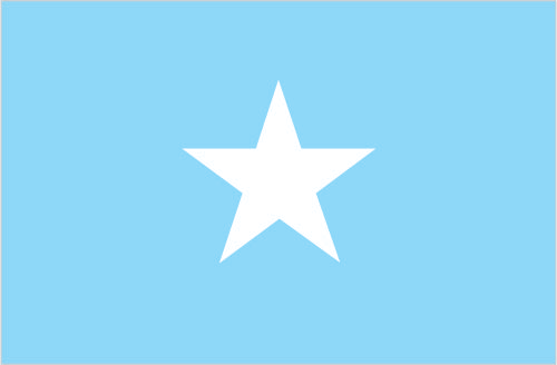
| Flag description: light blue with a large white five-pointed star in the center; the blue field was originally influenced by the flag of the UN, but today is said to denote the sky and the neighboring Indian Ocean; the five points of the star represent the five regions in the horn of Africa that are inhabited by Somali people: the former British Somaliland and Italian Somaliland (which together make up Somalia), Djibouti, Ogaden (Ethiopia), and the North East Province (Kenya). | Border length: total: 2,385 km. Border countries (total: 3): Djibouti 61 km, Ethiopia 1,640 km, Kenya 684 km. |
Did you know about Somalia?
- Modern Somalia is a combination of the former Italian territory and British Somaliland. Since 1991 it has been in a state of civil war.
- Until 1973, Somali was an unwritten language.
- The Boswellia trees that grow in northern Somalia are an important source of frankincense-a resin used to make expensive incense and perfume.
Facts of Somalia (SO)
Name conventional long form: Federal Republic of Somalia, conventional short form: Somalia, local long form: Jamhuuriyadda Federaalkaa Soomaaliya, local short form: Soomaaliya, former: Somali Republic, Somali Democratic Republic, etymology: “Land of the Somali” (ethnic group)
Codes: ISO; SO, Internet; .so
Capital city: Mogadishu
Language(s): Somali (official language), Arabic (official language, according to the Transitional Federal Charter), Italian, English
National holiday(s): Foundation of the Somali Republic, 1 July (1960)
Motto: N/A
Currency: Somali shilling (SOS), since 1962
GPS: 10 00 N, 49 00 E, Mogadishu; 2 04 N 45 20 E
Location: Eastern Africa, bordering the Gulf of Aden and the Indian Ocean, east of Ethiopia
Geography note: strategic location on Horn of Africa along southern approaches to Bab el Mandeb and route through Red Sea and Suez Canal
Land boundaries: Djibouti 61 km, Ethiopia 1,640 km, Kenya 684 km, total: 2,385 km
Maritime boundaries: Gulf of Aden, Indian Ocean
Coastline: 3,025 km
Area: total: 637,657 sq km; land: 627,337 sq km, water: 10,320 sq km (total 246 200,64 mi2), almost five times the size of Alabama; slightly smaller than Texas.
Roadways: total: 22,100 km, paved: 2,608 km, unpaved: 19,492 km (2000)
Waterways: N/A
Local time (capital): UTC+3, 8 hours ahead of Washington DC during Standard Time
Note to the local time: N/A
Population in Somalia: 15 181 925
Population in Mogadishu: 1 554 000 (including the metropolitan areas)
Urbanization: urban population: 39.6% of total population (2015)
Major urban areas population: MOGADISHU (capital) 2.138 million; Hargeysa 760,000 (2015)
Population growth rate: 1.92% (2016 estimate)
Birth rate: 40 births / 1,000 population (2016 estimate)
Death rate: 13.3 deaths / 1,000 population (2016 estimate)
Age structure: 0-14 years: 43.42% (male 2,345,536 / female 2,351,886) 15-24 years: 18.87% (male 1,031,804 / female 1,009,831) 25-54 years: 31.47% (male 1,762,093 / female 1,641,699) 55-64 years: 4.02% (male 213,259 / female 221,520) 65 years and over: 2.22% (male 92,966 / female 146,760) (2016 estimate)
Median age: total: 17.9 years; male: 18.1 years, female: 17.8 years (2016 estimate)
Ethnic groups: Somali 85%, Bantu and other non-Somali 15% (including 30,000 Arabs)
Religions: Sunni Muslim (Islam) (official, according to the Transitional Federal Charter)
Government type: Federal parliamentary republic
Legal system: mixed legal system of civil law, Islamic law, and customary law (referred to as Xeer)
National anthem: Qolobaa Calankeed (Praise to the flag)
Known national hazards: recurring droughts; frequent dust storms over eastern plains in summer; floods during rainy season
Major infectious diseases: The degree of risk(s): very high food or waterborne diseases: bacterial and protozoal diarrhea, hepatitis A and E, and typhoid fever vectorborne diseases: dengue fever, malaria, and Rift Valley feverwater contact disease: schistosomiasis animal contact disease: rabies (2016)
Land use: agricultural land: 70.3%; arable land 1.8%; permanent crops 0%; permanent pasture 68.5%; forest: 10.6%; other: 19.1% (2011 estimate)
Agricultural products: bananas, sorghum, corn, coconuts, rice, sugarcane, mangoes, sesame seeds, beans; cattle, sheep, goats; fish
Industries: light industries, including sugar refining, textiles, wireless communication
Export commodities: livestock, bananas, hides, fish, charcoal, scrap metal
Main export partners: UAE 45.8%, Yemen 19.7%, Oman 15.9% (2015)
Import commodities: manufactures, petroleum products, foodstuffs, construction materials, qat
Main import partners: Djibouti 18.7%, India 16.5%, China 11.8%, Oman 8.7%, Kenya 6.1%, Pakistan 4.4% (2015)
Navigate the countries in Africa faster and easier while driving, use the interactive Google maps for your driving directions. The continuously updated database contains over 220 countries and territories digitally mapped, hundreds of millions of businesses and places around the world positioned on the map.
Get fresh GPS navigation, traffic, and transit information – no matter what part of Somalia, Mogadishu, any other city and country in Africa, or the world you’re in.
Do you like this Somalia information page? Please don’t forget to share it with others! Thank you.