Rwanda Google maps and Driving Directions
Get free driving directions, Google maps, traffic information for Rwanda, and Kigali (GPS: 1 57 S 30 03 E), the capital city of the country located in (the) Central Africa, east of the Democratic Republic of the Congo, north of Burundi.
Find any address in Kigali on the Google map of Rwanda (RW) with ease or calculate your up to date itinerary to and from Rwanda or its neighboring counties like Burundi, Democratic Republic of Congo, Tanzania, Uganda.
Sightseeing and exploring in Africa starts here, thanks to Google because its Earth Engine combines a multi-petabyte catalog of updated satellite imagery and geospatial datasets with planetary-scale analysis capabilities. Wonder the world, use the satellite map function of the Google maps to explore or see differences on the Earth’s surface, inland, or the surrounding areas of Rwanda.
Google Maps Rwanda
Rwanda lies just south of the equator in east central Africa, far from the nearest sea port. Since independence from France in 1962, ethnic tensions have dominated politics.
Rwanda is mostly grassy uplands and hills; relief is mountainous with altitude declining from west to east.
The map above fully covers Rwanda with its road routes from cities to towns, road intersections in any region, provinces, prefectures, also with free driving directions in Kigali or to the neighboring towns and countries. To look at the detailed map about a particular quarter in Kigali, please click on the area and zoom to the place you are interested in the Google maps of Rwanda (RW).
Be creative, use the extras of this Google map; This is a detailed, clear, zoomable, large road map of Rwanda with its administrative divisions; 4 provinces (in French – provinces, singular – province; in Kinyarwanda – intara for singular and plural) and 1 city* (in French – ville; in Kinyarwanda – umujyi); Est (Eastern), Kigali*, Nord (Northern), Ouest (Western), Sud (Southern).
The interactive map above is also may be used as the satellite map of Rwanda, or as a reverse search map for finding an address from its GPS coordinates.
Rwanda, in east-central Africa, is surrounded by the Democratic Republic of the Congo, Uganda, Tanzania, and Burundi. It is slightly smaller than Maryland. Steep mountains and deep valleys cover most of the country. Lake Kivu in the northwest, at an altitude of 4,829 ft (1,472 m), is the highest lake in Africa. Extending north of it are the Virunga Mountains, which include the volcano Karisimbi (14,187 ft 4,324 m), Rwanda’s highest point.
Rwanda (area: 26 338 sq km / 10 169,15 sq mi), where the official language is English, French, Kinyarwanda, Kiswahili, Swahili, lying in Africa and using the currency; Rwandan franc (RWF), since 1964, set their clock to UTC+2. That means they are 7 hours ahead of Washington DC during Standard Time in Kigali, the capital. Note to the time difference: N/A.
The climate in Rwanda; Tropical, though tempered by the altitude. Two wet seasons are separated by a dry season, from June to August. Heaviest rain in the west.
Geography in a nutshell; A series of plateaus descend from the ridge of volcanic peaks in the west to the Akagera River on the eastern border. The Great Rift Valley also passes through this region.
Click here for more detailed information about Rwanda.
Driving directions Rwanda
The Google maps and Google Satellite maps of Rwanda above showing the country, located next to Burundi, Democratic Republic of Congo, Tanzania, Uganda. For your further reference, the latitude and longitude coordinates of Rwanda are 2 00 S, 30 00 E , while the capital, Kigali found at 1 57 S 30 03 E.
When you are traveling around Rwanda, Kigali, or its other cities, use this routing tool, providing up to date route planning service free of charge.
Look no further; get accurate driving directions in Rwanda, Africa, by filling the route planner form below.
Since Google acquired and introduced its digitalized maps in 2004, you’re probably familiar with its base functions, like finding an address or driving directions to locations. Still, Google maps also accommodate bicyclists, pedestrians, and also public transportation with special directions and customizable routes.
About Rwanda and the capital, Kigali
 |
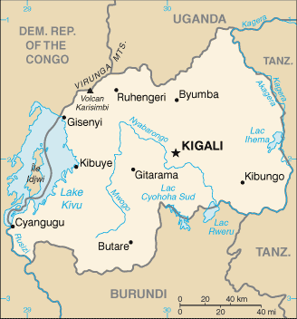 |
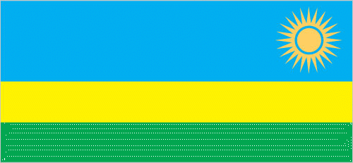
| The national flag of Rwanda | Borderline map of Rwanda |
| Flag description: three horizontal bands of sky blue (top, double width), yellow, and green, with a golden sun with 24 rays near the fly end of the blue band; blue represents happiness and peace, yellow economic development and mineral wealth, green hope of prosperity and natural resources; the sun symbolizes unity, as well as enlightenment and transparency from ignorance. | Border length: total: 930 km. Border countries (total: 4): Burundi 315 km, Democratic Republic of the Congo 221 km, Tanzania 222 km, Uganda 172 km. |
Did you know about Rwanda?
- Rwanda, originally part of German East Africa, taken over by Belgium after the First World War. It became independent on July 1, 1962.
- Rwandas parliament in 2008 was the first in the world to have more women members than men.
- One of the mountain gorillas last refuges is Rwandas Volcanoes National Park.
Facts of Rwanda (RW)
Name conventional long form: Republic of Rwanda, conventional short form: Rwanda, local long form: Republika y’u Rwanda, local short form: Rwanda, former: Ruanda, German East Africa, etymology: the name translates as “domain” in the native Kinyarwanda language
Codes: ISO; RW, Internet; .rw
Capital city: Kigali
Language(s): Kinyarwanda only (official language, universal Bantu vernacular) 93.2%, Kinyarwanda and other language(s) 6.2%, French (official language) and other language(s) 0.1%, English (official language) and other language(s) 0.1%, Swahili (or Kiswahili, used in commercial centers) 0.02%, other 0.03%, unspecified 0.3% (2002 estimate)
National holiday(s): Independence Day, 1 July (1962)
Motto: Ubumwe, Umurimo, Gukunda Igihugu (Unity, Work, Patriotism)
Currency: Rwandan franc (RWF), since 1964
GPS: 2 00 S, 30 00 E, Kigali; 1 57 S 30 03 E
Location: Central Africa, east of the Democratic Republic of the Congo, north of Burundi
Geography note: landlocked country; most of the country is savanna grassland with the population predominantly rural
Land boundaries: Burundi 315 km, Democratic Republic of the Congo 221 km, Tanzania 222 km, Uganda 172 km, total: 930 km
Maritime boundaries: N/A
Coastline: 0 km (landlocked country)
Area: total: 26,338 sq km; land: 24,668 sq km, water: 1,670 sq km (total 10 169,15 mi2), slightly smaller than Maryland.
Roadways: total: 4,700 km, paved: 1,207 km, unpaved: 3,493 km (2012)
Waterways: (Lac Kivu navigable by shallow-draft barges and native craft) (2011)
Local time (capital): UTC+2, 7 hours ahead of Washington DC during Standard Time
Note to the local time: N/A
Population in Rwanda: 12 501 156
Population in Kigali: 1 004 000 (including the metropolitan areas)
Urbanization: urban population: 28.8% of total population (2015)
Major urban areas population: KIGALI (capital) 1.257 million (2015)
Population growth rate: 2.53% (2016 estimate)
Birth rate: 33.3 births / 1,000 population (2016 estimate)
Death rate: 8.8 deaths / 1,000 population (2016 estimate)
Age structure: 0-14 years: 41.53% (male 2,719,248 / female 2,674,688) 15-24 years: 18.87% (male 1,226,141 / female 1,225,009) 25-54 years: 32.93% (male 2,142,936 / female 2,134,064) 55-64 years: 4.09% (male 249,447 / female 282,225) 65 years and over: 2.58% (male 138,834 / female 195,831) (2016 estimate)
Median age: total: 19 years; male: 18.7 years, female: 19.2 years (2016 estimate)
Ethnic groups: Hutu (Bantu) 84%, Tutsi (Hamitic) 15%, Twa (Pygmy) 1%
Religions: Roman Catholic 49.5%, Protestant 39.4% (includes Adventist 12.2% and other Protestant 27.2%), other Christian 4.5%, Muslim 1.8%, animist 0.1%, other 0.6%, none 3.6% (2001), unspecified 0.5% (2002 estimate)
Government type: Unitary semi-presidential republic
Legal system: mixed legal system of civil law, based on German and Belgian models, and customary law; judicial review of legislative acts in the Supreme Court
National anthem: Rwanda nziza (Beautiful Rwanda)
Known national hazards: periodic droughts; the volcanic Virunga Mountains are in the northwest along the border with Democratic Republic of the Congovolcanism: Visoke (elev. 3,711 m), located on the border with the Democratic Republic of the Congo, is the country’s only historically active volcano
Major infectious diseases: The degree of risk(s): very high food or waterborne diseases: bacterial diarrhea, hepatitis A, and typhoid fever vectorborne diseases: malaria and dengue feveranimal contact disease: rabies (2016)
Land use: agricultural land: 74.5%; arable land 47%; permanent crops 10.1%; permanent pasture 17.4%; forest: 18%; other: 7.5% (2011 estimate)
Agricultural products: coffee, tea, pyrethrum (insecticide made from chrysanthemums), bananas, beans, sorghum, potatoes; livestock
Industries: cement, agricultural products, small-scale beverages, soap, furniture, shoes, plastic goods, textiles, cigarettes
Export commodities: coffee, tea, hides, tin ore
Main export partners: Democratic Republic of the Congo 19.8%, US 10.8%, China 10.3%, Swaziland 7.9%, Malaysia 7%, Pakistan 6.2%, Germany 5.9%, Thailand 5.5% (2015)
Import commodities: foodstuffs, machinery and equipment, steel, petroleum products, cement and construction material
Main import partners: Uganda 15.7%, Kenya 11.8%, India 8.7%, China 8.7%, UAE 8.6%, Russia 6.6%, Tanzania 5.1% (2015)
Navigate the countries in Africa faster and easier while driving, use the interactive Google maps for your driving directions. The continuously updated database contains over 220 countries and territories digitally mapped, hundreds of millions of businesses and places around the world positioned on the map.
Get fresh GPS navigation, traffic, and transit information – no matter what part of Rwanda, Kigali, any other city and country in Africa, or the world you’re in.
Do you like this Rwanda information page? Please don’t forget to share it with others! Thank you.