United Kingdom Google maps and Driving Directions
Get free driving directions, Google maps, traffic information for the United Kingdom, and London (GPS: 51 30 N 0 05 W), the capital city of the country located in (the) Western Europe, islands – including the northern one-sixth of the island of Ireland – between the North Atlantic Ocean and the North Sea; northwest of France.
Find any address in London on the Google map of the United Kingdom (UK) with ease or calculate your up to date itinerary to and from the United Kingdom or its neighboring counties like Ireland.
Sightseeing and exploring in Europe starts here, thanks to Google because its Earth Engine combines a multi-petabyte catalog of updated satellite imagery and geospatial datasets with planetary-scale analysis capabilities. Wonder the world, use the satellite map function of the Google maps to explore or see differences on the Earth’s surface, inland, or the surrounding areas of the United Kingdom.
Google Maps United Kingdom
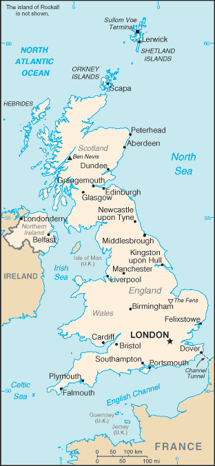
Separated from continental Europe by the English Channel, the UK consists of Great Britain (England, Wales, and Scotland), several smaller islands, and Northern Ireland.
The United Kingdom is mostly rugged hills and low mountains; level to rolling plains in east and southeast.
The map above fully covers the United Kingdom with its road routes from cities to towns, road intersections in any region, provinces, prefectures, also with free driving directions in London or to the neighboring towns and countries. To look at the detailed map about a particular quarter in London, please click on the area and zoom to the place you are interested in the Google maps of the United Kingdom (UK).
Be creative, use the extras of this Google map; This is a detailed, clear, zoomable, large road map of the United Kingdom with its administrative divisions; England: 27 two-tier counties, 32 London boroughs and 1 City of London or Greater London, 36 metropolitan districts, 56 unitary authorities (including 4 single-tier counties*)two-tier counties: Buckinghamshire, Cambridgeshire, Cumbria, Derbyshire, Devon, Dorset, East Sussex, Essex, Gloucestershire, Hampshire, Hertfordshire, Kent, Lancashire, Leicestershire, Lincolnshire, Norfolk, North Yorkshire, Northamptonshire, Nottinghamshire, Oxfordshire, Somerset, Staffordshire, Suffolk, Surrey, Warwickshire, West Sussex, WorcestershireLondon boroughs and City of London or Greater London: Barking and Dagenham, Barnet, Bexley, Brent, Bromley, Camden, Croydon, Ealing, Enfield, Greenwich, Hackney, Hammersmith and Fulham, Haringey, Harrow, Havering, Hillingdon, Hounslow, Islington, Kensington and Chelsea, Kingston upon Thames, Lambeth, Lewisham, City of London, Merton, Newham, Redbridge, Richmond upon Thames, Southwark, Sutton, Tower Hamlets, Waltham Forest, Wandsworth, Westminstermetropolitan districts: Barnsley, Birmingham, Bolton, Bradford, Bury, Calderdale, Coventry, Doncaster, Dudley, Gateshead, Kirklees, Knowlsey, Leeds, Liverpool, Manchester, Newcastle upon Tyne, North Tyneside, Oldham, Rochdale, Rotherham, Salford, Sandwell, Sefton, Sheffield, Solihull, South Tyneside, St. Helens, Stockport, Sunderland, Tameside, Trafford, Wakefield, Walsall, Wigan, Wirral, Wolverhamptonunitary authorities: Bath and North East Somerset, Blackburn with Darwen, Bedford, Blackpool, Bournemouth, Bracknell Forest, Brighton and Hove, City of Bristol, Central Bedfordshire, Cheshire East, Cheshire West and Chester, Cornwall, Darlington, Derby, Durham County*, East Riding of Yorkshire, Halton, Hartlepool, Herefordshire*, Isle of Wight*, Isles of Scilly, City of Kingston upon Hull, Leicester, Luton, Medway, Middlesbrough, Milton Keynes, North East Lincolnshire, North Lincolnshire, North Somerset, Northumberland*, Nottingham, Peterborough, Plymouth, Poole, Portsmouth, Reading, Redcar and Cleveland, Rutland, Shropshire, Slough, South Gloucestershire, Southampton, Southend-on-Sea, Stockton-on-Tees, Stoke-on-Trent, Swindon, Telford and Wrekin, Thurrock, Torbay, Warrington, West Berkshire, Wiltshire, Windsor and Maidenhead, Wokingham, YorkNorthern Ireland: 5 borough councils, 4 district councils, 2 city councilsborough councils: Antrim and Newtownabbey; Ards and North Down; Armagh, Banbridge, and Craigavon; Causeway Coast and Glens; Mid and East Antrimdistrict councils: Derry and Strabane; Fermanagh and Omagh; Mid Ulster; Newry, Murne, and Downcity councils: Belfast; Lisburn and CastlereaghScotland: 32 council areascouncil areas: Aberdeen City, Aberdeenshire, Angus, Argyll and Bute, Clackmannanshire, Dumfries and Galloway, Dundee City, East Ayrshire, East Dunbartonshire, East Lothian, East Renfrewshire, City of Edinburgh, Eilean Siar (Western Isles), Falkirk, Fife, Glasgow City, Highland, Inverclyde, Midlothian, Moray, North Ayrshire, North Lanarkshire, Orkney Islands, Perth and Kinross, Renfrewshire, Shetland Islands, South Ayrshire, South Lanarkshire, Stirling, The Scottish Borders, West Dunbartonshire, West LothianWales: 22 unitary authoritiesunitary authorities: Blaenau Gwent, Bridgend, Caerphilly, Cardiff, Carmarthenshire, Ceredigion, Conwy, Denbighshire, Flintshire, Gwynedd, Isle of Anglesey, Merthyr Tydfil, Monmouthshire, Neath Port Talbot, Newport, Pembrokeshire, Powys, Rhondda Cynon Taff, Swansea, The Vale of Glamorgan, Torfaen, Wrexham.
The interactive map above is also may be used as the satellite map of the United Kingdom or as a reverse search map for finding an address from its GPS coordinates.
The United Kingdom, consisting of Great Britain (England, Wales, and Scotland ) and Northern Ireland, is twice the size of New York State. England, in the southeast part of the British Isles, is separated from Scotland on the north by the granite Cheviot Hills from them the Pennine chain of uplands extends south through the center of England, reaching its highest point in the Lake District in the northwest. To the west along the border of Wales – a land of steep hills and valleys are the Cambrian Mountains, while the Cotswolds, a range of hills in Gloucestershire, extend into the surrounding shires. Significant rivers flowing into the North Sea are the Thames, Humber, Tees, and Tyne. In the west are the Severn and Wye, which empty into the Bristol Channel and are navigable, as are the Mersey and Ribble.
The United Kingdom (area: 242 900 sq km / 93 784,18 sq mi), where the official language is English, lying in Europe and using the currency; British pound (GBP), set their clock to UTC 0. That means they are 5 hours ahead of Washington DC during Standard Time in London, the capital. Note to the time difference: Daylight saving time: +1hr begins last Sunday in March; ends last Sunday in October. Note: applies to the United Kingdom proper not to its overseas dependencies or territories.
The climate in the United Kingdom; Generally mild, temperate, and highly changeable. Rain is relatively well distributed throughout the year. The west is generally wetter than the east, and the south warmer than the north. Winter snow is common in upland areas.
Geography in a nutshell; Rugged uplands dominate the landscape of Scotland, Wales, and northern England. All of the peaks in the United Kingdom over 4000 ft (1219 m) are in highland Scotland. The Pennine mountains, known as the “backbone of England,” run the length of northern England. Lowland England rises into several ranges of rolling hills, and there is an interconnected system of rivers and canals. Over 600 islands, many uninhabited, lie west and north of the Scottish mainland.
Click here for more detailed information about the United Kingdom.
Driving directions the United Kingdom
The Google maps and Google Satellite maps of the United Kingdom above showing the country, located next to Ireland. For your further reference, the latitude and longitude coordinates of the United Kingdom are 54 00 N, 2 00 W , while the capital, London found at 51 30 N 0 05 W.
When you are traveling around the United Kingdom, London, or its other cities, use this routing tool, providing up to date route planning service free of charge.
Look no further; get accurate driving directions in the United Kingdom, Europe, by filling the route planner form below.
Since Google acquired and introduced its digitalized maps in 2004, you’re probably familiar with its base functions, like finding an address or driving directions to locations. Still, Google maps also accommodate bicyclists, pedestrians, and also public transportation with special directions and customizable routes.
About the United Kingdom and the capital, London
 |
 |
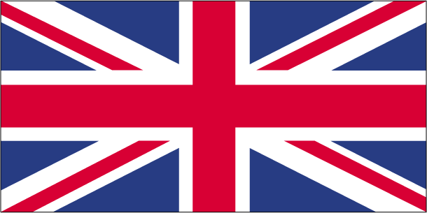
| The national flag of the United Kingdom | Borderline map of the United Kingdom |
| Flag description: a blue field with the red cross of Saint George (patron saint of England) edged in white superimposed on the diagonal red cross of Saint Patrick (patron saint of Ireland), which superimposed on the diagonal white cross of Saint Andrew (patron saint of Scotland); adequately known as the Union Flag, but commonly called the Union Jack; the design and colors (especially the Blue Ensign) have been the basis for several other flags including other Commonwealth countries and their constituent states or provinces, and British overseas territories. | Border length: total: 443 km. Border countries (total: 1): Ireland 443 km. |
About London
London is the most happening city in Europe – lively, fast-paced, and teeming with action. London touts its fascinating contradictions: it’s both an overwhelming jumble of antiquity and a world leader in the latest music, fashion, and food. As stimulating as the city is, however, you’ll want to tear yourself away to visit legendary Stonehenge, Oxford University, and the famous city of Bath. Samuel Johnson said, “When a man is tired of London, he is tired of life; for there’s in London all that life can afford.” We’ll survey a segment of that life: ancient monuments, literary shrines, museums, walking tours, Parliament debates, royal castles, waxworks, palaces, cathedrals, and parks.
Did you know about the United Kingdom?
- The United Kingdom formed in 1707, uniting England, Scotland, and Wales. In 1801 Ireland joined, but in 1921 the south broke away.
- The UK has no formal written constitution, but a stable government system based on Parliament, which originated as a check on royal power in the 13th century.
- The countries that make up the UK are all ruled over by the same monarch. While being different in culture and character, all four share a common language, government, and currency.
Facts of the United Kingdom (UK)
Name conventional long form: the United Kingdom of Great Britain and Northern Ireland; note – the island of Great Britain includes England, Scotland, and Wales, conventional short form: the United Kingdom abbreviation: UK, etymology: self-descriptive country name; the designation “Great Britain,” in the sense of “Larger Britain,” dates back to medieval times and was used to distinguish the island from “Little Britain,” or Brittany in modern France; the name Ireland derives from the Gaelic “Eriu,” the matron goddess of Ireland (goddess of the land)
Codes: ISO; UK, Internet; .uk
Capital city: London
Language(s): English. Note: the following are recognized regional languages: Scots (about 30% of the population of Scotland), Scottish Gaelic (about 60,000 in Scotland), Welsh (about 20% of the population of Wales), Irish (about 10% of the population of Northern Ireland), Cornish (some 2,000 to 3,000 in Cornwall) (2012 estimate)
National holiday(s): the UK does not celebrate one particular national holiday
Motto: Dieu et mon droit
Currency: British pound (GBP)
GPS: 54 00 N, 2 00 W, London; 51 30 N 0 05 W
Location: Western Europe, islands – including the northern one-sixth of the island of Ireland – between the North Atlantic Ocean and the North Sea; northwest of France
Geography note: lies near vital North Atlantic sea lanes; only 35 km from France and linked by tunnel under the English Channel (the Channel Tunnel or Chunnel); because of heavily indented coastline, no location is more than 125 km from tidal waters
Land boundaries: Ireland 443 km, total: 443 km
Maritime boundaries: N/A
Coastline: 12,429 km
Area: total: 243,610 sq km; land: 241,930 sq km, water: 1,680 sq km (total 93 784,18 mi2), twice the size of Pennsylvania; slightly smaller than Oregon.
Roadways: total: 394,428 km, paved: 394,428 km (includes 3,519 km of expressways) (2009)
Waterways: 3,200 km (620 km used for commerce) (2009)
Local time (capital): UTC 0, 5 hours ahead of Washington DC during Standard Time
Note to the local time: Daylight saving time: +1hr begins last Sunday in March; ends last Sunday in October. Note: applies to the United Kingdom proper not to its overseas dependencies or territories
Population in the United Kingdom: 66 573 504
Population in London: 9 005 000 (including the metropolitan areas)
Urbanization: urban population: 82.6% of total population (2015)
Major urban areas population: LONDON (capital) 10.313 million; Manchester 2.646 million; Birmingham 2.515 million; Glasgow 1.223 million; Southampton/Portsmouth 882,000; Liverpool 870,000 (2015)
Population growth rate: 0.53% (2016 estimate)
Birth rate: 12.1 births / 1,000 population (2016 estimate)
Death rate: 9.4 deaths / 1,000 population (2016 estimate)
Age structure: 0-14 years: 17.44% (male 5,761,311 / female 5,476,649) 15-24 years: 12.15% (male 3,997,150 / female 3,830,268) 25-54 years: 40.74% (male 13,367,242 / female 12,883,674) 55-64 years: 11.77% (male 3,760,020 / female 3,820,525) 65 years and over: 17.9% (male 5,170,542 / female 6,363,047) (2016 estimate)
Median age: total: 40.5 years; male: 39.3 years, female: 41.7 years (2016 estimate)
Ethnic groups: white 87.2%, black/African/Caribbean/black British 3%, Asian/Asian British: Indian 2.3%, Asian/Asian British: Pakistani 1.9%, mixed 2%, other 3.7% (2011 estimate)
Religions: Christian (includes Anglican, Roman Catholic, Presbyterian, Methodist) 59.5%, Muslim 4.4%, Hindu 1.3%, other 2%, unspecified 7.2%, none 25.7% (2011 estimate)
Government type: Unitary parliamentary constitutional monarchy
Legal system: common law system; has nonbinding judicial review of Acts of Parliament under the Human Rights Act of 1998
National anthem: God save the Queen
Known national hazards: winter windstorms; floods
Major infectious diseases: N/A
Land use: agricultural land: 71%; arable land 25.1%; permanent crops 0.2%; permanent pasture 45.7%; forest: 11.9%; other: 17.1% (2011 estimate)
Agricultural products: cereals, oilseed, potatoes, vegetables; cattle, sheep, poultry; fish
Industries: machine tools, electric power equipment, automation equipment, railroad equipment, shipbuilding, aircraft, motor vehicles and parts, electronics and communications equipment, metals, chemicals, coal, petroleum, paper and paper products, food processing, t
Export commodities: manufactured goods, fuels, chemicals; food, beverages, tobacco
Main export partners: US 14.6%, Germany 10.1%, Switzerland 7%, China 6%, France 5.9%, Netherlands 5.8%, Ireland 5.5% (2015)
Import commodities: manufactured goods, machinery, fuels; foodstuffs
Main import partners: Germany 14.8%, China 9.8%, US 9.2%, Netherlands 7.5%, France 5.8%, Belgium 5% (2015)
Navigate the countries in Europe faster and easier while driving, use the interactive Google maps for your driving directions. The continuously updated database contains over 220 countries and territories digitally mapped, hundreds of millions of businesses and places around the world positioned on the map.
Get fresh GPS navigation, traffic, and transit information – no matter what part of the United Kingdom, London, any other city and country in Europe, or the world you’re in.
Do you like this United Kingdom information page? Please don’t forget to share it with others! Thank you.