Estonia Google maps and Driving Directions
Get free driving directions, Google maps, traffic information for Estonia, and Tallinn (GPS: 59 26 N 24 43 E), the capital city of the country located in (the) Eastern Europe, bordering the Baltic Sea and Gulf of Finland, between Latvia and Russia.
Find any address in Tallinn on the Google map of Estonia (EE) with ease or calculate your up to date itinerary to and from Estonia or its neighboring counties like Latvia, Russia.
Sightseeing and exploring in Europe starts here, thanks to Google because its Earth Engine combines a multi-petabyte catalog of updated satellite imagery and geospatial datasets with planetary-scale analysis capabilities. Wonder the world, use the satellite map function of the Google maps to explore or see differences on the Earth’s surface, inland, or the surrounding areas of Estonia.
Google Maps Estonia
The smallest and most Western-oriented of the former Soviet-ruled Baltic states, Estonia is also the most developed, but its standard of living is well below the EU average.
Estonia is marshy, lowlands; flat in the north, hilly in the south.
The map above fully covers Estonia with its road routes from cities to towns, road intersections in any region, provinces, prefectures, also with free driving directions in Tallinn or to the neighboring towns and countries. To look at the detailed map about a particular quarter in Tallinn, please click on the area and zoom to the place you are interested in the Google maps of Estonia (EE).
Be creative, use the extras of this Google map; This is a detailed, clear, zoomable, large road map of Estonia with its administrative divisions; 15 counties (maakonnad, singular – maakond); Harjumaa (Tallinn), Hiiumaa (Kardla), Ida-Virumaa (Johvi), Jarvamaa (Paide), Jogevamaa (Jogeva), Laanemaa (Haapsalu), Laane-Virumaa (Rakvere), Parnumaa (Parnu), Polvamaa (Polva), Raplamaa (Rapla), Saaremaa (Kuressaare), Tartumaa (Tartu), Valgamaa (Valga), Viljandimaa (Viljandi), Vorumaa (Voru). Note: counties have the administrative center name following in parentheses.
The interactive map above is also may be used as the satellite map of Estonia, or as a reverse search map for finding an address from its GPS coordinates.
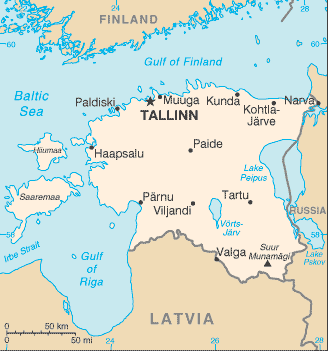
Estonia is mainly a lowland country that is bordered by the Baltic Sea, Latvia, and Russia. It has numerous lakes and forests and many rivers, most draining northward into the Gulf of Finland or eastward into Lake Peipus, its largest lake.
Estonia (area: 45 227 sq km / 17 462,24 sq mi), where the official language is Estonian, lying in Europe and using the currency; Euro (EUR), since 2011, set their clock to UTC+2. That means they are 7 hours ahead of Washington DC during Standard Time in Tallinn, the capital. Note to the time difference: Daylight saving time: +1hr begins last Sunday in March; ends last Sunday in October.
The climate in Estonia; Maritime, with some continental extremes. Harsh winters, with cool summers and damp springs.
Geography in a nutshell; Estonias terrain is flat, boggy, and partly forested, with over 1500 islands. Lake Peipus forms much of the eastern border with Russia.
Click here for more detailed information about Estonia.
Driving directions Estonia
The Google maps and Google Satellite maps of Estonia above showing the country, located next to Latvia, Russia. For your further reference, the latitude and longitude coordinates of Estonia are 59 00 N, 26 00 E , while the capital, Tallinn found at 59 26 N 24 43 E.
When you are traveling around Estonia, Tallinn, or its other cities, use this routing tool, providing up to date route planning service free of charge.
Look no further; get accurate driving directions in Estonia, Europe, by filling the route planner form below.
Since Google acquired and introduced its digitalized maps in 2004, you’re probably familiar with its base functions, like finding an address or driving directions to locations. Still, Google maps also accommodate bicyclists, pedestrians, and also public transportation with special directions and customizable routes.
About Estonia and the capital, Tallinn
 |
 |
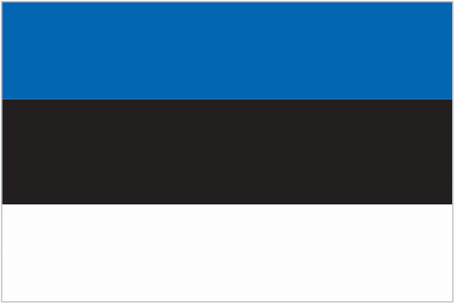
| The national flag of Estonia | Borderline map of Estonia |
| Flag description: three equal horizontal bands of blue (top), black, and white; various interpretations are linked to the flag colors; blue represents faith, loyalty, and devotion, while also reminiscent of the sky, sea, and lakes of the country; black symbolizes the soil of the country and the dark past and suffering endured by the Estonian people; white refers to the striving towards enlightenment and virtue, and is the color of birch bark and snow, as well as summer nights illuminated by the midnight sun. | Border length: total: 657 km. Border countries (total: 2): Latvia 333 km, Russia 324 km. |
About Tallinn
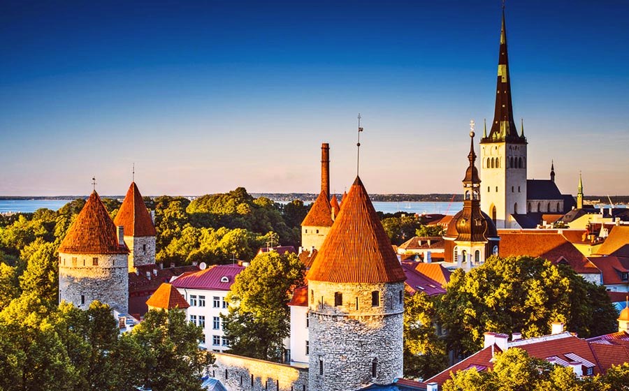
Tallinn, Estonia’s compact, buzzing capital, with its enchanting heart surrounded by medieval walls, has been shaped by nearly a millennium of outside influence. While the fairytale Old Town has become the ideal weekend getaway for city-break tourists, the Estonian capital’s growing importance as a regional center for business, arts, and technology has provided it with a go-ahead contemporary feel coupled with bags of hedonistic energy.
Did you know about Estonia?
- Estonia declared independence from the Russian Empire in 1918. In 1940 it was annexed by the Soviet Union, but recovered its independence in 1991.
- Estonia pioneered online voting in 2007, and plans voting by cell phone in 2011.
- Tallinn, Estonias capital, is an important seaport and high-tech center with a beautiful medieval Old Town.
Estonia is a low-lying republic in northeastern Europe bounded by the Gulf of Finland and the Baltic Sea in the north and west, Russia in the east and Latvia in the south. Estonia is also a former constituent republic of the USSR and consists largely of a marshy, undulating plain with numerous forests, lakes and wetlands and offshore islands.
Numerous rivers and streams drain the country, and almost one-quarter of the land is forested. Estonia’s capital and largest city and port are Tallinn. Over 70 percent of the population live in cities, towns or urban areas.
Agriculture is very important in Estonia, with the raising of livestock being the prime activity. The forests provide valuable sawn timber and raw materials for paper, pulp and furniture making and there are a modest marine and freshwater fishing industry — most industries based in the north. Tourism is a small but growing contributor to the economy.
Facts of Estonia (EE)
Name conventional long form: Republic of Estonia, conventional short form: Estonia, local long form: Eesti Vabariik, local short form: Eesti, former: Estonian Soviet Socialist Republic, etymology: the country name may be derived from the Aesti, an ancient people who lived along the eastern Baltic Sea in the first centuries A.D.
Codes: ISO; EE, Internet; .ee
Capital city: Tallinn
Language(s): Estonian (official language) 68.5%, Russian 29.6%, Ukrainian 0.6%, other 1.2%, unspecified 0.1% (2011 estimate)
National holiday(s): Independence Day, 24 February (1918)
Motto: N/A
Currency: Euro (EUR), since 2011
GPS: 59 00 N, 26 00 E, Tallinn; 59 26 N 24 43 E
Location: Eastern Europe, bordering the Baltic Sea and Gulf of Finland, between Latvia and Russia
Geography note: the mainland terrain is flat, boggy, and partly wooded; offshore lie more than 1,500 islands
Land boundaries: Latvia 333 km, Russia 324 km, total: 657 km
Maritime boundaries: Baltic Sea, Gulf of Finland
Coastline: 3,794 km
Area: total: 45,228 sq km; land: 42,388 sq km, water: 2,840 sq km (total 17 462,24 mi2), about twice the size of New Jersey.
Roadways: total: 58,412 km (includes urban roads)paved: 10,427 km (includes 115 km of expressways), unpaved: 47,985 km (2011)
Waterways: 335 km (320 km are navigable year round) (2011)
Local time (capital): UTC+2, 7 hours ahead of Washington DC during Standard Time
Note to the local time: Daylight saving time: +1hr begins last Sunday in March; ends last Sunday in October
Population in Estonia: 1 306 788
Population in Tallinn: 379 000 (including the metropolitan areas)
Urbanization: urban population: 67.5% of total population (2015)
Major urban areas population: TALLINN (capital) 391,000 (2015)
Population growth rate: -0.54% (2016 estimate)
Birth rate: 10.3 births / 1,000 population (2016 estimate)
Death rate: 12.5 deaths / 1,000 population (2016 estimate)
Age structure: 0-14 years: 16.12% (male 104,011 / female 98,809) 15-24 years: 9.3% (male 60,714 / female 56,291) 25-54 years: 41.64% (male 263,762 / female 260,334) 55-64 years: 13.47% (male 76,063 / female 93,479) 65 years and over: 19.47% (male 82,968 / female 162,114) (2016 estimate)
Median age: total: 42.4 years; male: 39 years, female: 45.8 years (2016 estimate)
Ethnic groups: Estonian 68.7%, Russian 24.8%, Ukrainian 1.7%, Belarusian 1%, Finn 0.6%, other 1.6%, unspecified 1.6% (2011 estimate)
Religions: Lutheran 9.9%, Orthodox 16.2%, other Christian (including Methodist, Seventh-Day Adventist, Roman Catholic, Pentecostal) 2.2%, other 0.9%, none 54.1%, unspecified 16.7% (2011 estimate)
Government type: Unitary parliamentary constitutional republic
Legal system: civil law system
National anthem: My Fatherland, My Happiness and Joy
Known national hazards: sometimes flooding occurs in the spring
Major infectious diseases: The degree of risk(s): intermediatevectorborne disease: tickborne encephalitis (2016)
Land use: agricultural land: 22.2%; arable land 14.9%; permanent crops 0.1%; permanent pasture 7.2%; forest: 52.1%; other: 25.7% (2011 estimate)
Agricultural products: grain, potatoes, vegetables; livestock and dairy products; fish
Industries: food, engineering, electronics, wood and wood products, textiles; information technology, telecommunications
Export commodities: machinery and electrical equipment 34%, food products and beverages 9%, mineral fuels 9%, wood and wood products 10%, metals 7%, furniture 9%, vehicles and parts 6%, chemicals 5% (2015 estimate)
Main export partners: Sweden 18.8%, Finland 16%, Latvia 10.4%, Russia 6.7%, Lithuania 5.9%, Germany 5.2%, Norway 4.1% (2015)
Import commodities: machinery and electrical equipment 28 %, mineral fuels 11%, food and food products 10%, vehicles 9%, chemical products 8%, metals 8% (2015 estimate)
Main import partners: Finland 14.5%, Germany 11%, Lithuania 9%, Sweden 8.5%, Latvia 8.3%, Poland 7.4%, Russia 6.1%, Netherlands 5.5%, China 4.8% (2015)
Navigate the countries in Europe faster and easier while driving, use the interactive Google maps for your driving directions. The continuously updated database contains over 220 countries and territories digitally mapped, hundreds of millions of businesses and places around the world positioned on the map.
Get fresh GPS navigation, traffic, and transit information – no matter what part of Estonia, Tallinn, any other city and country in Europe, or the world you’re in.
Do you like this Estonia information page? Please don’t forget to share it with others! Thank you.