Tajikistan Google maps and Driving Directions
Get free driving directions, Google maps, traffic information for Tajikistan, and Dushanbe (GPS: 38 33 N 68 46 E), the capital city of the country located in (the) Central Asia, west of China, south of Kyrgyzstan.
Find any address in Dushanbe on the Google map of Tajikistan (TJ) with ease or calculate your up to date itinerary to and from Tajikistan or its neighboring counties like Afghanistan, China, Kyrgyzstan, Uzbekistan.
Sightseeing and exploring in Asia starts here, thanks to Google because its Earth Engine combines a multi-petabyte catalog of updated satellite imagery and geospatial datasets with planetary-scale analysis capabilities. Wonder the world, use the satellite map function of the Google maps to explore or see differences on the Earth’s surface, inland, or the surrounding areas of Tajikistan.
Google Maps Tajikistan
Tajikistan lies landlocked on the western slopes of the Pamirs in central Asia. Soon after the breakup of the USSR in 1991, civil war erupted between ruling communists and Islamists.
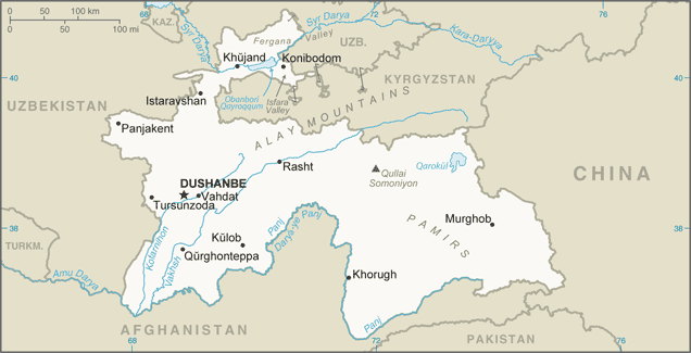
Tajikistan is mountainous region dominated by the Trans-Alay Range in the north and the Pamirs in the southeast; western Fergana Valley in north, Kofarnihon and Vakhsh Valleys in southwest.
The map above fully covers Tajikistan with its road routes from cities to towns, road intersections in any region, provinces, prefectures, also with free driving directions in Dushanbe or to the neighboring towns and countries. To look at the detailed map about a particular quarter in Dushanbe, please click on the area and zoom to the place you are interested in the Google maps of Tajikistan (TJ).
Be creative, use the extras of this Google map; This is a detailed, clear, zoomable, large road map of Tajikistan with its administrative divisions; 2 provinces (viloyatho, singular – viloyat), 1 autonomous province* (viloyati mukhtor), 1 capital region** (viloyati poytakht), and 1 area referred to as Districts Under Republic Administration***; Dushanbe**, Khatlon (Qurghonteppa), Kuhistoni Badakhshon [Gorno-Badakhshan]* (Khorugh), Nohiyahoi Tobei Jumhuri***, Sughd (Khujand). Note: the administrative center name follows in parentheses.
The interactive map above is also may be used as the satellite map of Tajikistan, or as a reverse search map for finding an address from its GPS coordinates.
Ninety-three percent of Tajikistan’s territory is mountainous, and the mountain glaciers are the source of its rivers. Tajikistan is an earthquake-prone area. The republic is bounded by China in the east, Afghanistan to the south, and Uzbekistan and Kyrgyzstan to the west and north. The central Asian republic also includes the Gorno-Badakh Shan Autonomous region. Tajikistan is slightly larger than the state of Illinois.
Tajikistan (area: 143 100 sq km / 55 251,20 sq mi), where the official language is Tajik, lying in Asia and using the currency; Tajikistani somoni (TJS), since 2000, set their clock to UTC+5. That means they are 10 hours ahead of Washington DC during Standard Time in Dushanbe, the capital. Note to the time difference: N/A.
The climate in Tajikistan; Continental extremes in the valleys. Bitterly cold winters in the mountains. Rainfall is low.
Geography in a nutshell; Mainly mountainous: bare slopes of the Pamir ranges, with fast-flowing rivers, cover most of the country. Small but fertile Fergana Valley in northwest.
Click here for more detailed information about Tajikistan.
Driving directions Tajikistan
The Google maps and Google Satellite maps of Tajikistan above showing the country, located next to Afghanistan, China, Kyrgyzstan, Uzbekistan. For your further reference, the latitude and longitude coordinates of Tajikistan are 39 00 N, 71 00 E , while the capital, Dushanbe found at 38 33 N 68 46 E.
When you are traveling around Tajikistan, Dushanbe, or its other cities, use this routing tool, providing up to date route planning service free of charge.
Look no further; get accurate driving directions in Tajikistan,, by filling the route planner form below.
Since Google acquired and introduced its digitalized maps in 2004, you’re probably familiar with its base functions, like finding an address or driving directions to locations. Still, Google maps also accommodate bicyclists, pedestrians, and also public transportation with special directions and customizable routes.
About Tajikistan and the capital, Dushanbe
 |
 |
| The national flag of Tajikistan | Borderline map of Tajikistan |
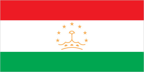
| Flag description: three horizontal stripes of red (top), a wider stripe of white, and green; a gold crown surmounted by seven gold, five-pointed stars is located in the center of the white stripe; red represents the sun, victory, and the unity of the nation, white stands for purity, cotton, and mountain snows, while green is the color of Islam and the bounty of nature; the crown symbolizes the Tajik people; the seven stars signify the Tajik magic number “seven” – a symbol of perfection and the embodiment of happiness. | Border length: total: 4,130 km. Border countries (total: 4): Afghanistan 1,357 km, China 477 km, Kyrgyzstan 984 km, Uzbekistan 1,312 km. |
Did you know about Tajikistan?
- A former member of the USSR, Tajikistan proclaimed independence in 1991, but Russian and communist influences remain strong.
- Carpet-making, an ancient tradition learned from Persia, is still a major source of revenue.
- Its plentiful supplies of uranium, used in nuclear power generation, are the mainstay of Tajikistans economy.
Facts of Tajikistan (TJ)
Name conventional long form: Republic of Tajikistan, conventional short form: Tajikistan, local long form: Jumhurii Tojikiston, local short form: Tojikiston, former: Tajik Soviet Socialist Republic, etymology: the Persian suffix “-stan” means “place of” or “country,” so the word Tajikistan literally means “Land of the Tajik [people]”
Codes: ISO; TJ, Internet; .tj
Capital city: Dushanbe
Language(s): Tajik (official language), Russian widely used in government and business. Note: different ethnic groups speak Uzbek, Kyrgyz, and Pashto
National holiday(s): Independence Day (or National Day), 9 September (1991)
Motto: N/A
Currency: Tajikistani somoni (TJS), since 2000
GPS: 39 00 N, 71 00 E, Dushanbe; 38 33 N 68 46 E
Location: Central Asia, west of China, south of Kyrgyzstan
Geography note: landlocked country; highest point, Qullai Ismoili Somoni (formerly Communism Peak), was the tallest mountain in the former USSR
Land boundaries: Afghanistan 1,357 km, China 477 km, Kyrgyzstan 984 km, Uzbekistan 1,312 km, total: 4,130 km
Maritime boundaries: N/A
Coastline: 0 km (landlocked country)
Area: total: 144,100 sq km; land: 141,510 sq km, water: 2,590 sq km (total 55 251,20 mi2), slightly smaller than Wisconsin.
Roadways: total: 27,767 km (2000)
Waterways: 200 km (along Vakhsh River) (2011)
Local time (capital): UTC+5, 10 hours ahead of Washington DC during Standard Time
Note to the local time: N/A
Population in Tajikistan: 9 107 211
Population in Dushanbe: 739 000 (including the metropolitan areas)
Urbanization: urban population: 26.8% of total population (2015)
Major urban areas population: DUSHANBE (capital) 822,000 (2015)
Population growth rate: 1.66% (2016 estimate)
Birth rate: 23.8 births / 1,000 population (2016 estimate)
Death rate: 6.1 deaths / 1,000 population (2016 estimate)
Age structure: 0-14 years: 32.56% (male 1,380,959 / female 1,331,790) 15-24 years: 19.04% (male 804,625 / female 781,469) 25-54 years: 39.79% (male 1,640,657 / female 1,674,198) 55-64 years: 5.37% (male 205,541 / female 241,770) 65 years and over: 3.24% (male 112,279 / female 157,658) (2016 estimate)
Median age: total: 24.2 years; male: 23.6 years, female: 24.8 years (2016 estimate)
Ethnic groups: Tajik 84.3%, Uzbek 13.8% (includes Lakai, Kongrat, Katagan, Barlos, Yuz), other 2% (includes Kyrgyz, Russian, Turkmen, Tatar, Arab) (2010 estimate)
Religions: Sunni Muslim 85%, Shia Muslim 5%, other 10% (2003 estimate)
Government type: Unitary dominant-party presidential republic
Legal system: civil law system
National anthem: Surudi Milli (National Anthem)
Known national hazards: earthquakes; floods
Major infectious diseases: The degree of risk(s): high food or waterborne diseases: bacterial diarrhea, hepatitis A, and typhoid fever vectorborne disease: malaria (2016)
Land use: agricultural land: 34.7%; arable land 6.1%; permanent crops 0.9%; permanent pasture 27.7%; forest: 2.9%; other: 62.4% (2011 estimate)
Agricultural products: cotton, grain, fruits, grapes, vegetables; cattle, sheep, goats
Industries: aluminum, cement, vegetable oil
Export commodities: aluminum, electricity, cotton, fruits, vegetable oil, textiles
Main export partners: Turkey 19.7%, Kazakhstan 17.6%, Switzerland 13.7%, Iran 8.7%, Afghanistan 7.5%, Russia 5.1%, China 4.9%, Italy 4.8% (2015)
Import commodities: petroleum products, aluminum oxide, machinery and equipment, foodstuffs
Main import partners: China 42.3%, Russia 17.9%, Kazakhstan 13.1%, Iran 4.7% (2015)
Navigate the countries in faster and easier while driving, use the interactive Google maps for your driving directions. The continuously updated database contains over 220 countries and territories digitally mapped, hundreds of millions of businesses and places around the world positioned on the map.
Get fresh GPS navigation, traffic, and transit information – no matter what part of Tajikistan, Dushanbe, any other city and country in Asia, or the world you’re in.
Do you like this Tajikistan information page? Please don’t forget to share it with others! Thank you.