Kazakhstan Google maps and Driving Directions
Get free driving directions, Google maps, traffic information for Kazakhstan, and Astana (GPS: 51 10 N 71 25 E), the capital city of the country located in (the) Central Asia, northwest of China; a small portion west of the Ural (Zhayyq) River in easternmost Europe.
Find any address in Astana on the Google map of Kazakhstan (KZ) with ease or calculate your up to date itinerary to and from Kazakhstan or its neighboring counties like China, Kyrgyzstan, Russia, Turkmenistan, Uzbekistan.
Sightseeing and exploring in Asia starts here, thanks to Google because its Earth Engine combines a multi-petabyte catalog of updated satellite imagery and geospatial datasets with planetary-scale analysis capabilities. Wonder the world, use the satellite map function of the Google maps to explore or see differences on the Earth’s surface, inland, or the surrounding areas of Kazakhstan.
Google Maps Kazakhstan
Kazakhstan was the last of the former Soviet republics to declare independence. Foreign investment in the oil and natural gas sector is strengthening its regional power.
Kazakhstan is vast flat steppe extending from the Volga in the west to the Altai Mountains in the east and from the plains of western Siberia in the north to oases and deserts of Central Asia in the south.
The map above fully covers Kazakhstan with its road routes from cities to towns, road intersections in any region, provinces, prefectures, also with free driving directions in Astana or to the neighboring towns and countries. To look at the detailed map about a particular quarter in Astana, please click on the area and zoom to the place you are interested in the Google maps of Kazakhstan (KZ).
Be creative, use the extras of this Google map; This is a detailed, clear, zoomable, large road map of Kazakhstan with its administrative divisions; 14 provinces (oblyslar, singular – oblys) and 2 cities* (qalalar, singular – qala); Almaty (Taldyqorghan), Almaty*, Aqmola (Kokshetau), Aqtobe, Astana*, Atyrau, Batys Qazaqstan [West Kazakhstan] (Oral), Mangghystau (Aqtau), Ongtustik Qazaqstan [South Kazakhstan] (Shymkent), Pavlodar, Qaraghandy, Qostanay, Qyzylorda, Shyghys Qazaqstan [East Kazakhstan] (Oskemen), Soltustik Qazaqstan [North Kazakhstan] (Petropavl), Zhambyl (Taraz). Note: administrative divisions have the same names as their administrative centers (exceptions have the administrative center name following in parentheses); in 1995, the Governments of Kazakhstan and Russia entered into an agreement whereby Russia would lease for a period of 20 years an area of 6,000 sq km enclosing the Baykonur space launch facilities and the city of Bayqongyr (Baykonur, formerly Leninsk); in 2004, a new agreement extended the lease to 2050.
The interactive map above is also may be used as the satellite map of Kazakhstan, or as a reverse search map for finding an address from its GPS coordinates.
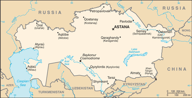
Kazakhstan lies in the north of the central Asian republics and is bounded by Russia in the north, China in the east, Kyrgyzstan and Uzbekistan in the south, and the Caspian Sea and part of Turkmenistan in the west. It has almost 1,177 mi (1,894 km) of coastline on the Caspian Sea. Kazakhstan is about four times the size of Texas. The territory is mostly steppe land with hilly plains and plateaus.
Kazakhstan (area: 2 724 910 sq km / 1 052 093,20 sq mi), where the official language is Kazakh, Russian, lying in Asia and using the currency; Kazakhstani tenge (KZT), since 1993, set their clock to UTC+6. That means they are 11 hours ahead of Washington DC during Standard Time in Astana, the capital. Note to the time difference: Kazakhstan has two time zones.
The climate in Kazakhstan; Dry continental. Temperature variations between desert south and northern steppes are large. Winters are mildest near the Caspian Sea.
Geography in a nutshell; Mainly steppe. Volga Delta and Caspian Sea in the west. Central plateau. Inhospitable Altai Mountains in the east. Semidesert in the south.
Click here for more detailed information about Kazakhstan.
Driving directions Kazakhstan
The Google maps and Google Satellite maps of Kazakhstan above showing the country, located next to China, Kyrgyzstan, Russia, Turkmenistan, Uzbekistan. For your further reference, the latitude and longitude coordinates of Kazakhstan are 48 00 N, 68 00 E , while the capital, Astana found at 51 10 N 71 25 E.
When you are traveling around Kazakhstan, Astana, or its other cities, use this routing tool, providing up to date route planning service free of charge.
Look no further; get accurate driving directions in Kazakhstan, Asia, by filling the route planner form below.
Since Google acquired and introduced its digitalized maps in 2004, you’re probably familiar with its base functions, like finding an address or driving directions to locations. Still, Google maps also accommodate bicyclists, pedestrians, and also public transportation with special directions and customizable routes.
About Kazakhstan and the capital, Astana
 |
 |
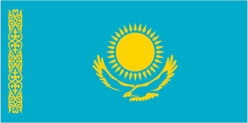
| The national flag of Kazakhstan | Borderline map of Kazakhstan |
| Flag description: a gold sun with 32 rays above a soaring golden steppe eagle, both centered on a sky blue background; the hoist side displays a national ornamental pattern “koshkar-muiz” (the horns of the ram) in gold; the blue color is of religious significance to the Turkic peoples of the country, and so symbolizes cultural and ethnic unity; it also represents the endless sky as well as water; the sun, a source of life and energy, exemplifies wealth and plenitude; the sun’s rays are shaped like grain, which is the basis of abundance and prosperity; the eagle has appeared on the flags of Kazakh tribes for centuries and represents freedom, power, and the flight to the future; blue and yellow are the national colors. | Border length: total: 13,364 km. Border countries (total: 5): China 1,765 km, Kyrgyzstan 1,212 km, Russia 7,644 km, Turkmenistan 413 km, Uzbekistan 2,330 km. |
Did you know about Kazakhstan?
- Part of Central Asia conquered by Russia in the 18th century, Kazakhstan was the largest republic to secede from the USSR.
- The Soviet-built Baykonyr space center is still an important launch site for international missions.
- The first Kazakhs were nomads who traveled around on horses. Horse-racing remains popular today, while kumis-fermented mares milk-is the national drink. Cheers!
Facts of Kazakhstan (KZ)
Name conventional long form: Republic of Kazakhstan, conventional short form: Kazakhstan, local long form: Qazaqstan Respublikasy, local short form: Qazaqstan, former: Kazakh Soviet Socialist Republic, etymology: the name “Kazakh” derives from the Turkic word “kaz” meaning “to wander,” recalling the Kazakh’s nomadic lifestyle; the Persian suffix “-stan” means “place of” or “country,” so the word Kazakhstan literally means “Land of the wanderers”
Codes: ISO; KZ, Internet; .kz
Capital city: Astana
Language(s): Kazakh (official language, Qazaq) 74% (understand spoken language), Russian (official language, used in everyday business, designated the “language of interethnic communication”) 94.4% (understand spoken language) (2009 estimate)
National holiday(s): Independence Day, 16 December (1991)
Motto: N/A
Currency: Kazakhstani tenge (KZT), since 1993
GPS: 48 00 N, 68 00 E, Astana; 51 10 N 71 25 E
Location: Central Asia, northwest of China; a small portion west of the Ural (Zhayyq) River in easternmost Europe
Geography note: world’s largest landlocked country; Russia leases approximately 6,000 sq km of territory enclosing the Baykonur Cosmodrome; in January 2004, Kazakhstan and Russia extended the lease to 2050
Land boundaries: China 1,765 km, Kyrgyzstan 1,212 km, Russia 7,644 km, Turkmenistan 413 km, Uzbekistan 2,330 km, total: 13,364 km
Maritime boundaries: Aral Sea, Caspian Sea
Coastline: 0 km (landlocked country); note – Kazakhstan borders the Aral Sea, now split into two bodies of water (1,070 km), and the Caspian Sea (1,894 km)
Area: total: 2,724,900 sq km; land: 2,699,700 sq km, water: 25,200 sq km (total 1 052 093,20 mi2), slightly less than four times the size of Texas.
Roadways: total: 97,418 km, paved: 87,140 km, unpaved: 10,278 km (2012)
Waterways: 4,000 km (on the Ertis (Irtysh) River (80%) and Syr Darya (Syrdariya) River) (2010)
Local time (capital): UTC+6, 11 hours ahead of Washington DC during Standard Time
Note to the local time: Kazakhstan has two time zones
Population in Kazakhstan: 18 403 860
Population in Astana: 288 200 (including the metropolitan areas)
Urbanization: urban population: 53.2% of total population (2015)
Major urban areas population: Almaty 1.523 million; ASTANA (capital) 759,000 (2015)
Population growth rate: 1.09% (2016 estimate)
Birth rate: 18.7 births / 1,000 population (2016 estimate)
Death rate: 8.2 deaths / 1,000 population (2016 estimate)
Age structure: 0-14 years: 25.68% (male 2,336,444 / female 2,378,769) 15-24 years: 14.66% (male 1,371,133 / female 1,319,938) 25-54 years: 42.5% (male 3,808,164 / female 3,994,781) 55-64 years: 9.77% (male 784,035 / female 1,008,935) 65 years and over: 7.4% (male 470,485 / female 887,669) (2016 estimate)
Median age: total: 30.3 years; male: 29 years, female: 31.6 years (2016 estimate)
Ethnic groups: Kazakh (Qazaq) 63.1%, Russian 23.7%, Uzbek 2.9%, Ukrainian 2.1%, Uighur 1.4%, Tatar 1.3%, German 1.1%, other 4.4% (2009 estimate)
Religions: Muslim 70.2%, Christian 26.2% (mainly Russian Orthodox), other 0.2%, atheist 2.8%, unspecified 0.5% (2009 estimate)
Government type: Unitary dominant-party presidential republic
Legal system: civil law system influenced by Roman-Germanic law and by the theory and practice of the Russian Federation
National anthem: My Kazakhstan
Known national hazards: earthquakes in the south; mudslides around Almaty
Major infectious diseases: N/A
Land use: agricultural land: 77.4%; arable land 8.9%; permanent crops 0%; permanent pasture 68.5%; forest: 1.2%; other: 21.4% (2011 estimate)
Agricultural products: grain (mostly spring wheat and barley), potatoes, vegetables, melons; livestock
Industries: oil, coal, iron ore, manganese, chromite, lead, zinc, copper, titanium, bauxite, gold, silver, phosphates, sulfur, uranium, iron and steel; tractors and other agricultural machinery, electric motors, construction materials
Export commodities: oil and oil products, natural gas, ferrous metals, chemicals, machinery, grain, wool, meat, coal
Main export partners: China 15.1%, Russia 12.3%, France 9.2%, Germany 7.9%, Italy 6.7%, Greece 4.1% (2015)
Import commodities: machinery and equipment, metal products, foodstuffs
Main import partners: Russia 32.9%, China 25.9%, Germany 4.2% (2015)
Navigate the countries in Asia faster and easier while driving, use the interactive Google maps for your driving directions. The continuously updated database contains over 220 countries and territories digitally mapped, hundreds of millions of businesses and places around the world positioned on the map.
Get fresh GPS navigation, traffic, and transit information – no matter what part of Kazakhstan, Astana, any other city and country in Asia, or the world you’re in.
Do you like this Kazakhstan information page? Please don’t forget to share it with others! Thank you.