Kyrgyzstan Google maps and Driving Directions
Get free driving directions, Google maps, traffic information for Kyrgyzstan, and Bishkek (GPS: 42 52 N 74 36 E), the capital city of the country located in (the) Central Asia, west of China, south of Kazakhstan.
Find any address in Bishkek on the Google map of Kyrgyzstan (KG) with ease or calculate your up to date itinerary to and from Kyrgyzstan or its neighboring counties like China, Kazakhstan, Tajikistan, Uzbekistan.
Sightseeing and exploring in Asia starts here, thanks to Google because its Earth Engine combines a multi-petabyte catalog of updated satellite imagery and geospatial datasets with planetary-scale analysis capabilities. Wonder the world, use the satellite map function of the Google maps to explore or see differences on the Earth’s surface, inland, or the surrounding areas of Kyrgyzstan.
Google Maps Kyrgyzstan
A small and mountainous landlocked state in central Asia, Kyrgyzstan is one of the least urbanized ex-Soviet republics, and was slow to develop its own sense of cultural identity.
Kyrgyzstan is peaks of the Tien Shan mountain range and associated valleys and basins encompass the entire country.
The map above fully covers Kyrgyzstan with its road routes from cities to towns, road intersections in any region, provinces, prefectures, also with free driving directions in Bishkek or to the neighboring towns and countries. To look at the detailed map about a particular quarter in Bishkek, please click on the area and zoom to the place you are interested in the Google maps of Kyrgyzstan (KG).
Be creative, use the extras of this Google map; This is a detailed, clear, zoomable, large road map of Kyrgyzstan with its administrative divisions; 7 provinces (oblustar, singular – oblus) and 2 cities* (shaarlar, singular – shaar); Batken Oblusu, Bishkek Shaary*, Chuy Oblusu (Bishkek), Jalal-Abad Oblusu, Naryn Oblusu, Osh Oblusu, Osh Shaary*, Talas Oblusu, Ysyk-Kol Oblusu (Karakol). Note: administrative divisions have the same names as their administrative centers (exceptions have the administrative center name following in parentheses).
The interactive map above is also may be used as the satellite map of Kyrgyzstan, or as a reverse search map for finding an address from its GPS coordinates.
Kyrgyzstan (formerly Kirghizia) is a rugged country with the Tien Shan mountain range covering approximately 95% of the whole territory. The mountaintops are perennially covered with snow and glaciers. Kyrgyzstan borders Kazakhstan on the north and northwest, Uzbekistan in the southwest, Tajikistan in the south, and China in the southeast. The republic has the same area as the state of Nebraska.
Kyrgyzstan (area: 199 951 sq km / 77 201,48 sq mi), where the official language is Kyrgyz, Russian, lying in Asia and using the currency; Kyrgyzstani som (KGS), since 1993, set their clock to UTC+6. That means they are 11 hours ahead of Washington DC during Standard Time in Bishkek, the capital. Note to the time difference: N/A.
The climate in Kyrgyzstan; Varies from permanent snow and cold deserts at high altitudes, to hot deserts in low regions.
Geography in a nutshell; The mountainous spurs of the Tien Shan range contain glaciers, alpine meadows, forests, and narrow valleys. Semidesert in the west.
Click here for more detailed information about Kyrgyzstan.
Driving directions Kyrgyzstan
The Google maps and Google Satellite maps of Kyrgyzstan above showing the country, located next to China, Kazakhstan, Tajikistan, Uzbekistan. For your further reference, the latitude and longitude coordinates of Kyrgyzstan are 41 00 N, 75 00 E , while the capital, Bishkek found at 42 52 N 74 36 E.
When you are traveling around Kyrgyzstan, Bishkek, or its other cities, use this routing tool, providing up to date route planning service free of charge.
Look no further; get accurate driving directions in Kyrgyzstan, Asia, by filling the route planner form below.
Since Google acquired and introduced its digitalized maps in 2004, you’re probably familiar with its base functions, like finding an address or driving directions to locations. Still, Google maps also accommodate bicyclists, pedestrians, and also public transportation with special directions and customizable routes.
About Kyrgyzstan and the capital, Bishkek
 |
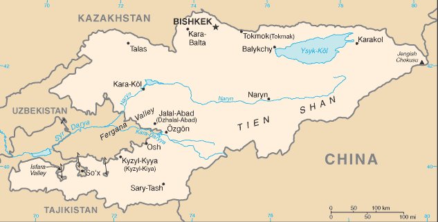 |
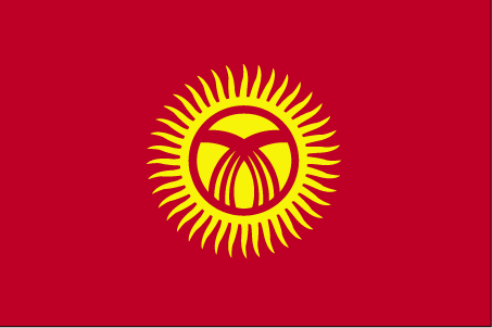
| The national flag of Kyrgyzstan | Borderline map of Kyrgyzstan |
| Flag description: red field with a yellow sun in the center having 40 rays representing the 40 Kyrgyz tribes; on the obverse side the rays run counterclockwise, on the reverse, clockwise; in the center of the sun is a red ring crossed by two sets of three lines, a stylized representation of a “tunduk” – the crown of a traditional Kyrgyz yurt; red symbolizes bravery and valor, the sun evinces peace and wealth. | Border length: total: 4,573 km. Border countries (total: 4): China 1,063 km, Kazakhstan 1,212 km, Tajikistan 984 km, Uzbekistan 1,314 km. |
Did you know about Kyrgyzstan?
- Conquered by Russia under the tsars, in 1991 the Republic of Kyrgyzstan became the last of the Soviet Union Republics to declare sovereignty.
- Kyrgyz folklore is based around the 1000-year-old poem, Manas, which takes a week to recite.
- Mountainous Kyrgyzstan has a wealth of exploitable natural resources: the perfect landscape for hydroelectric power stations, and vast reserves of mercury and gold, which it exports.
Facts of Kyrgyzstan (KG)
Name conventional long form: Kyrgyz Republic, conventional short form: Kyrgyzstan, local long form: Kyrgyz Respublikasy, local short form: Kyrgyzstan, former: Kirghiz Soviet Socialist Republic, etymology: a combination of the Turkic words “kyrg” (forty) and “-yz” (tribes) with the Persian suffix “-stan” (country) creating the meaning “Land of the forty tribes”; the name refers to the forty clans united by the legendary Kyrgyz hero, MANAS
Codes: ISO; KG, Internet; .kg
Capital city: Bishkek
Language(s): Kyrgyz (official language) 71.4%, Uzbek 14.4%, Russian (official language) 9%, other 5.2% (2009 estimate)
National holiday(s): Independence Day, 31 August (1991)
Motto: N/A
Currency: Kyrgyzstani som (KGS), since 1993
GPS: 41 00 N, 75 00 E, Bishkek; 42 52 N 74 36 E
Location: Central Asia, west of China, south of Kazakhstan
Geography note: landlocked country; entirely mountainous, dominated by the Tien Shan range; 94% of the country is 1,000 m above sea level with an average elevation of 2,750 m; many tall peaks, glaciers, and high-altitude lakes
Land boundaries: China 1,063 km, Kazakhstan 1,212 km, Tajikistan 984 km, Uzbekistan 1,314 km, total: 4,573 km
Maritime boundaries: N/A
Coastline: 0 km (landlocked country)
Area: total: 199,951 sq km; land: 191,801 sq km, water: 8,150 sq km (total 77 201,48 mi2), slightly smaller than South Dakota.
Roadways: total: 34,000 km (2007)
Waterways: 600 km (2010)
Local time (capital): UTC+6, 11 hours ahead of Washington DC during Standard Time
Note to the local time: N/A
Population in Kyrgyzstan: 6 132 932
Population in Bishkek: 824 900 (including the metropolitan areas)
Urbanization: urban population: 35.7% of total population (2015)
Major urban areas population: BISHKEK (capital) 865,000 (2015)
Population growth rate: 1.09% (2016 estimate)
Birth rate: 22.6 births / 1,000 population (2016 estimate)
Death rate: 6.6 deaths / 1,000 population (2016 estimate)
Age structure: 0-14 years: 30.12% (male 883,875 / female 841,362) 15-24 years: 17.47% (male 508,656 / female 492,046) 25-54 years: 39.68% (male 1,112,777 / female 1,159,967) 55-64 years: 7.59% (male 189,684 / female 245,202) 65 years and over: 5.13% (male 112,494 / female 181,490) (2016 estimate)
Median age: total: 26.2 years; male: 25.2 years, female: 27.3 years (2016 estimate)
Ethnic groups: Kyrgyz 70.9%, Uzbek 14.3%, Russian 7.7%, Dungan 1.1%, other 5.9% (includes Uyghur, Tajik, Turk, Kazakh, Tatar, Ukrainian, Korean, German) (2009 estimate)
Religions: Muslim 75%, Russian Orthodox 20%, other 5%
Government type: Unitary parliamentary republic
Legal system: civil law system which includes features of French civil law and Russian Federation laws
National anthem: N/A
Known national hazards: N/A
Major infectious diseases: N/A
Land use: agricultural land: 55.4%; arable land 6.7%; permanent crops 0.4%; permanent pasture 48.3%; forest: 5.1%; other: 39.5% (2011 estimate)
Agricultural products: cotton, potatoes, vegetables, grapes, fruits and berries; sheep, goats, cattle, wool
Industries: small machinery, textiles, food processing, cement, shoes, sawn logs, refrigerators, furniture, electric motors, gold, rare earth metals
Export commodities: gold, cotton, wool, garments, meat; mercury, uranium, electricity; machinery; shoes
Main export partners: Switzerland 26%, Uzbekistan 22.6%, Kazakhstan 20.8%, UAE 4.9%, Turkey 4.5%, Afghanistan 4.5%, Russia 4.2% (2015)
Import commodities: oil and gas, machinery and equipment, chemicals, foodstuffs
Main import partners: China 56.4%, Russia 17.1%, Kazakhstan 9.9% (2015)
Navigate the countries in Asia faster and easier while driving, use the interactive Google maps for your driving directions. The continuously updated database contains over 220 countries and territories digitally mapped, hundreds of millions of businesses and places around the world positioned on the map.
Get fresh GPS navigation, traffic, and transit information – no matter what part of Kyrgyzstan, Bishkek, any other city and country in Asia, or the world you’re in.
Do you like this Kyrgyzstan information page? Please don’t forget to share it with others! Thank you.