Republic of the Congo Google maps and Driving Directions
Get free driving directions, Google maps, traffic information for Republic of the Congo, and Brazzaville (GPS: 4 15 S 15 17 E), the capital city of the country located in (the) Central Africa, bordering the South Atlantic Ocean, between Angola and Gabon.
Find any address in Brazzaville on the Google map of Republic of the Congo (CF) with ease or calculate your up to date itinerary to and from Republic of the Congo or its neighboring counties like Angola, Cameroon, Central African Republic, Democratic Republic of Congo, Gabon.
Sightseeing and exploring in Africa starts here, thanks to Google because its Earth Engine combines a multi-petabyte catalog of updated satellite imagery and geospatial datasets with planetary-scale analysis capabilities. Wonder the world, use the satellite map function of the Google maps to explore or see differences on the Earth’s surface, inland, or the surrounding areas of Republic of the Congo.
Google Maps Republic of the Congo
Astride the equator in west-central Africa, this former French colony emerged from 20 years of Marxist-Leninist rule in 1990. Democracy was soon overshadowed by years of violence.
Republic of the Congo is coastal plain, southern basin, central plateau, northern basin.
The map above fully covers Republic of the Congo with its road routes from cities to towns, road intersections in any region, provinces, prefectures, also with free driving directions in Brazzaville or to the neighboring towns and countries. To look at the detailed map about a particular quarter in Brazzaville, please click on the area and zoom to the place you are interested in the Google maps of Republic of the Congo (CF).
Be creative, use the extras of this Google map; This is a detailed, clear, zoomable, large road map of Republic of the Congo with its administrative divisions; 12 departments (departments, singular – department); Bouenza, Brazzaville, Cuvette, Cuvette-Ouest, Kouilou, Lekoumou, Likouala, Niari, Plateaux, Pointe-Noire, Pool, Sangha.
The interactive map above is also may be used as the satellite map of Republic of the Congo, or as a reverse search map for finding an address from its GPS coordinates.
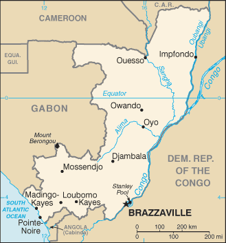
The Congo is situated in west-central Africa astride the equator. It borders Gabon, Cameroon, the Central African Republic, the Democratic Republic of the Congo, and the Angola exclave of Cabinda, with a short stretch of coast on the South Atlantic. Its area is nearly three times that of Pennsylvania. Most of the inland is tropical rain forest, drained by tributaries of the Congo River.
Republic of the Congo (area: 342 000 sq km / 132 046,88 sq mi), where the official language is French, lying in Africa and using the currency; Central African CFA franc (XAF), set their clock to UTC+1. That means they are 6 hours ahead of Washington DC during Standard Time in Brazzaville, the capital. Note to the time difference: N/A.
The climate in Republic of the Congo; Hot, tropical. Temperatures rarely fall below 86°F (30°C). Two wet and two dry seasons. Rainfall is heaviest south of the equator.
Geography in a nutshell; Mostly forest- or savanna- covered plateaus, drained by the Ubangi and Congo river systems. Narrow coastal plain is lined with sand dunes and lagoons.
Click here for more detailed information about Republic of the Congo.
Driving directions Republic of the Congo
The Google maps and Google Satellite maps of Republic of the Congo above showing the country, located next to Angola, Cameroon, Central African Republic, Democratic Republic of Congo, Gabon. For your further reference, the latitude and longitude coordinates of Republic of the Congo are 1 00 S, 15 00 E , while the capital, Brazzaville found at 4 15 S 15 17 E.
When you are traveling around Republic of the Congo, Brazzaville, or its other cities, use this routing tool, providing up to date route planning service free of charge.
Look no further; get accurate driving directions in Republic of the Congo, Africa, by filling the route planner form below.
Since Google acquired and introduced its digitalized maps in 2004, you’re probably familiar with its base functions, like finding an address or driving directions to locations. Still, Google maps also accommodate bicyclists, pedestrians, and also public transportation with special directions and customizable routes.
About Republic of the Congo and the capital, Brazzaville
 |
 |
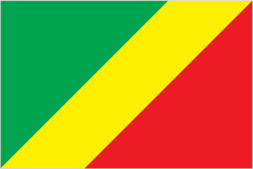
| The national flag of Republic of the Congo | Borderline map of Republic of the Congo |
| Flag description: divided diagonally from the lower hoist side by a yellow band; the upper triangle (hoist side) is green and the lower triangle is red; green symbolizes agriculture and forests, yellow the friendship and nobility of the people, red is unexplained but has been associated with the struggle for independence. Note: uses the popular Pan-African colors of Ethiopia. | Border length: total: 5,008 km. Border countries (total: 5): Angola 231 km, Cameroon 494 km, Central African Republic 487 km, Democratic Republic of the Congo 1,229 km, Gabon 2,567 km. |
Did you know about Republic of the Congo?
- Congo was a French colony until independence as Congo-Brazzaville in 1960. After a coup in 1964, it became the Peoples Republic (1970-1991).
- In 1970, Congo became the first African country to declare itself a communist state.
- The smaller and more northern of the two nations that share a name, Congo is home to some extraordinary wildlife, including the immense Giant African Snail, which can grow up to 13in (33cm) long.
Facts of Republic of the Congo (CF)
Name conventional long form: Republic of the Congo, conventional short form: Congo (Brazzaville), local long form: Republique du Congo, local short form: Congo, former: French Congo, Middle Congo, People’s Republic of the Congo, Congo/Brazzaville, etymology: named for the Congo River, which makes up much of the country’s eastern border; the river name derives from Kongo, a Bantu kingdom that occupied its mouth at the time of Portuguese discovery in the late 15th century and whose name stems from its people the Bakongo, meaning “hunters”
Codes: ISO; CF, Internet; .cg
Capital city: Brazzaville
Language(s): French (official language), Lingala and Monokutuba (lingua franca trade languages), many local languages and dialects (of which Kikongo is the most widespread)
National holiday(s): Independence Day, 15 August (1960)
Motto: Unité, Travail, Progrés (Unity, Work, Progress)
Currency: Central African CFA franc (XAF)
GPS: 1 00 S, 15 00 E, Brazzaville; 4 15 S 15 17 E
Location: Central Africa, bordering the South Atlantic Ocean, between Angola and Gabon
Geography note: about 70% of the population lives in Brazzaville, Pointe-Noire, or along the railroad between them
Land boundaries: Angola 231 km, Cameroon 494 km, Central African Republic 487 km, Democratic Republic of the Congo 1,229 km, Gabon 2,567 km, total: 5,008 km
Maritime boundaries: N/A
Coastline: 169 km
Area: total: 342,000 sq km; land: 341,500 sq km, water: 500 sq km (total 132 046,88 mi2), slightly smaller than Montana.
Roadways: total: 17,000 km, paved: 1,212 km, unpaved: 15,788 km (2006)
Waterways: 1,120 km (commercially navigable on Congo and Oubanqui Rivers above Brazzaville; there are many ferries across the river to Kinshasa; the Congo south of Brazzaville–Kinshasa to the coast is not navigable because of rapids, necessitating a rail connection to Pointe Noire; other rivers are used for local traffic only) (2011)
Local time (capital): UTC+1, 6 hours ahead of Washington DC during Standard Time
Note to the local time: N/A
Population in Republic of the Congo: 5 399 895
Population in Brazzaville: 5 125 821 (including the metropolitan areas)
Urbanization: urban population: 65.4% of total population (2015)
Major urban areas population: BRAZZAVILLE (capital) 1.888 million; Pointe-Noire 969,000 (2015)
Population growth rate: 2.06% (2016 estimate)
Birth rate: 35.1 births / 1,000 population (2016 estimate)
Death rate: 9.7 deaths / 1,000 population (2016 estimate)
Age structure: 0-14 years: 41.53% (male 1,016,677 / female 998,331) 15-24 years: 17.26% (male 419,248 / female 418,397) 25-54 years: 34% (male 831,091 / female 818,853) 55-64 years: 4.18% (male 101,118 / female 101,879) 65 years and over: 3.03% (male 64,519 / female 82,299) (2016 estimate)
Median age: total: 19.7 years; male: 19.6 years, female: 19.9 years (2016 estimate)
Ethnic groups: Kongo 48%, Sangha 20%, M’Bochi 12%, Teke 17%, Europeans and other 3%
Religions: Roman Catholic 33.1%, Awakening Churches/Christian Revival 22.3%, Protestant 19.9%, Salutiste 2.2%, Muslim 1.6%, Kimbanguiste 1.5%, other 8.1%, none 11.3% (2010 estimate)
Government type: Presidential republic
Legal system: mixed legal system of French civil law and customary law
National anthem: La Congolaise
Known national hazards: seasonal flooding
Major infectious diseases: The degree of risk(s): very high food or waterborne diseases: bacterial and protozoal diarrhea, hepatitis A, and typhoid fever vectorborne disease: malaria and dengue feveranimal contact disease: rabieswater contact disease: schistosomiasis (2016)
Land use: agricultural land: 31.1%; arable land 1.6%; permanent crops 0.2%; permanent pasture 29.3%; forest: 65.6%; other: 3.3% (2011 estimate)
Agricultural products: cassava (manioc, tapioca), sugar, rice, corn, peanuts, vegetables, coffee, cocoa; forest products
Industries: petroleum extraction, cement, lumber, brewing, sugar, palm oil, soap, flour, cigarettes
Export commodities: petroleum, lumber, plywood, sugar, cocoa, coffee, diamonds
Main export partners: China 42.1%, Italy 16.9%, US 4.9%, India 4.7%, Portugal 4.2% (2015)
Import commodities: capital equipment, construction materials, foodstuffs
Main import partners: China 20.3%, France 14.2%, South Korea 9.8%, US 4.9%, UK 4.4%, Italy 4.1%, India 4.1% (2015)
Navigate the countries in Africa faster and easier while driving, use the interactive Google maps for your driving directions. The continuously updated database contains over 220 countries and territories digitally mapped, hundreds of millions of businesses and places around the world positioned on the map.
Get fresh GPS navigation, traffic, and transit information – no matter what part of Republic of the Congo, Brazzaville, any other city and country in Africa, or the world you’re in.
Do you like this Republic of the Congo information page? Please don’t forget to share it with others! Thank you.