Belize Google maps and Driving Directions
Get free driving directions, Google maps, traffic information for Belize, and Belmopan (GPS: 17 15 N 88 46 W), the capital city of the country located in (the) Central America, bordering the Caribbean Sea, between Guatemala and Mexico.
Find any address in Belmopan on the Google map of Belize (BZ) with ease or calculate your up to date itinerary to and from Belize or its neighboring counties like Guatemala, Mexico.
Sightseeing and exploring in America starts here, thanks to Google because its Earth Engine combines a multi-petabyte catalog of updated satellite imagery and geospatial datasets with planetary-scale analysis capabilities. Wonder the world, use the satellite map function of the Google maps to explore or see differences on the Earth’s surface, inland, or the surrounding areas of Belize.
Google Maps Belize
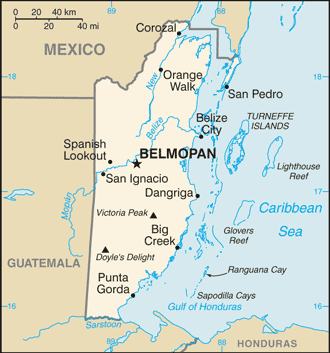
Belize lies on the eastern shore of the Yucatan Peninsula. Formerly called British Honduras, Belize was the last Central American country to gain its independence, in 1981.
Belize is flat, swampy coastal plain; low mountains in south.
The map above fully covers Belize with its road routes from cities to towns, road intersections in any region, provinces, prefectures, also with free driving directions in Belmopan or to the neighboring towns and countries. To look at the detailed map about a particular quarter in Belmopan, please click on the area and zoom to the place you are interested in the Google maps of Belize (BZ).
Be creative, use the extras of this Google map; This is a detailed, clear, zoomable, large road map of Belize with its administrative divisions; 6 districts; Belize, Cayo, Corozal, Orange Walk, Stann Creek, Toledo.
The interactive map above is also may be used as the satellite map of Belize, or as a reverse search map for finding an address from its GPS coordinates.
Belize is situated on the Caribbean Sea, south of Mexico and east and north of Guatemala in Central America. In area, it is about the size of New Hampshire. Most of the country is heavily forested with various hardwoods. Mangrove swamps and cays along the coast give way to hills and mountains in the interior. The highest point is Victoria Peak, 3,681 ft (1,122 m).
Belize (area: 22 966 sq km / 8 867,22 sq mi), where the official language is English, lying in America and using the currency; Belize dollar (BZD), since 1885, set their clock to UTC-6. That means they are 1 hour behind Washington DC during Standard Time in Belmopan, the capital. Note to the time difference: N/A.
The climate in Belize; Tropical. Very hot and humid, with May-December rainy season.
Geography in a nutshell; Almost half the land area is forested. Low mountains in southeast. Flat swampy coastal plains.
Click here for more detailed information about Belize.
Driving directions Belize
The Google maps and Google Satellite maps of Belize above showing the country, located next to Guatemala, Mexico. For your further reference, the latitude and longitude coordinates of Belize are 17 15 N, 88 45 W , while the capital, Belmopan found at 17 15 N 88 46 W.
When you are traveling around Belize, Belmopan, or its other cities, use this routing tool, providing up to date route planning service free of charge.
Look no further; get accurate driving directions in Belize, Central America and the Caribbean, by filling the route planner form below.
Since Google acquired and introduced its digitalized maps in 2004, you’re probably familiar with its base functions, like finding an address or driving directions to locations. Still, Google maps also accommodate bicyclists, pedestrians, and also public transportation with special directions and customizable routes.
About Belize and the capital, Belmopan
 |
 |
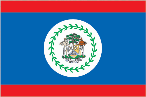
| The national flag of Belize | Borderline map of Belize |
| Flag description: blue with a narrow red stripe along the top and the bottom edges; centered is a large white disk bearing the coat of arms; the coat of arms features a shield flanked by two workers in front of a mahogany tree with the related motto SUB UMBRA FLOREO (I Flourish in the Shade) on a scroll at the bottom, all encircled by a green garland of 50 mahogany leaves; the colors are those of the two main political parties: blue for the PUP and red for the UDP; various elements of the coat of arms – the figures, the tools, the mahogany tree, and the garland of leaves – recall the logging industry that led to British settlement of Belize. Note: Belize’s flag is the only national flag that depicts human beings; two British overseas territories, Montserrat and the British Virgin Islands, also depict humans. | Border length: total: 542 km. Border countries (total: 2): Guatemala 266 km, Mexico 276 km. |
About Belize City
Despite a reputation for crime and violence, periodic devastation from passing hurricanes, and the loss of its capital status, Belize City remains the urban heart and soul of Belize. Most visitors treat Belize City merely as a transition point and transportation hub. This is probably what you’ll want to do, too. But if you’ve got a day or two to burn on a layover here, Belize City is an excellent place to walk around, admire the fleet of working wooden fish sloops, do some craft and souvenir shopping, and stock up on Marie Sharp’s Hot Sauce to bring home with you.
Long ago stripped of its status as the country’s capital, Belize City remains Belize’s business, transportation, and cultural hub. With a population of 71,000, Belize City is surrounded on three sides by water, and at high tide, it is nearly swamped. It’s a dense warren of narrow streets and canals (the latter being little more than open sewers and pungent in hot weather), modern stores, dilapidated shacks, and wooden mansions, coexisting in a seemingly chaotic jumble.
Did you know about Belize?
- Belize was originally known as British Honduras, a colony formed in 1862 from settlements on the coast of Guatemala.
- Belizes barrier reef is the second-largest in the world.
- Once a British colony, Belize is the only English-speaking country in Central America. It is the least populated country in the region and half its land is heavily forested.
Belize is the second-youngest nation in the Western Hemisphere, having been granted independence from Britain in 1981. It’s also a sparsely populated country, with just over 300,000 citizens and no large cities. Belize is the only country in Central America where English is the official and predominant language.
Originally a significant part of the ancient Maya empire, Belize was next settled by pirates and then colonized by the British, using slave labor. The descendants of each of these groups woven into the historical lore and cultural fabric of modern Belize. Add to the mix the independent Garífuna people, who settled along the remote southern shore in the early part of the 19th century, and the more recent waves of Mexican, Chinese, and East Indian immigrants, and you have an idea of the cultural meld that constitutes this unique Central American country. Belizeans of all cultural stripes tend to get along a lot better and with far fewer outward and untoward shows of racism than citizens of most other nations. This is a small country. The sense of community is strong and, even in the big city, people tend to know their neighbors; and almost everyone is somehow related.
Facts of Belize (BZ)
Name conventional long form: none, conventional short form: Belize, former: British Honduras, etymology: may be named for the Belize River, whose name possibly derives from the Maya word “belix,” meaning “muddy-watered”
Codes: ISO; BZ, Internet; .bz
Capital city: Belmopan
Language(s): English 62.9% (official language), Spanish 56.6%, Creole 44.6%, Maya 10.5%, German 3.2%, Garifuna 2.9%, other 1.8%, unknown 0.3%, none 0.2% (cannot speak). Note: shares sum to more than 100% because some respondents gave more than one answer on the census (2010 estimate)
National holiday(s): Battle of St. George’s Caye Day (National Day), September 10, 1798; Independence Day, 21 September (1981)
Motto: Sub umbra floreo (Under the shade I flourish)
Currency: Belize dollar (BZD), since 1885
GPS: 17 15 N, 88 45 W, Belmopan; 17 15 N 88 46 W
Location: Central America, bordering the Caribbean Sea, between Guatemala and Mexico
Geography note: only country in Central America without a coastline on the North Pacific Ocean
Land boundaries: Guatemala 266 km, Mexico 276 km, total: 542 km
Maritime boundaries: N/A
Coastline: 386 km
Area: total: 22,966 sq km; land: 22,806 sq km, water: 160 sq km (total 8 867,22 mi2), slightly smaller than Massachusetts.
Roadways: total: 2,870 km, paved: 488 km, unpaved: 2,382 km (2011)
Waterways: 825 km (navigable only by small craft) (2011)
Local time (capital): UTC-6, 1 hour behind Washington DC during Standard Time
Note to the local time: N/A
Population in Belize: 382 444
Population in Belmopan: 8 700 (including the metropolitan areas)
Urbanization: urban population: 44% of total population (2015)
Major urban areas population: BELMOPAN (capital) 17,000 (2014)
Population growth rate: 1.84% (2016 estimate)
Birth rate: 24.3 births / 1,000 population (2016 estimate)
Death rate: 6 deaths / 1,000 population (2016 estimate)
Age structure: 0-14 years: 34.41% (male 62,139 / female 59,611) 15-24 years: 20.71% (male 37,333 / female 35,960) 25-54 years: 36.26% (male 64,968 / female 63,346) 55-64 years: 4.84% (male 8,445 / female 8,666) 65 years and over: 3.78% (male 6,291 / female 7,099) (2016 estimate)
Median age: total: 22.4 years; male: 22.2 years, female: 22.6 years (2016 estimate)
Ethnic groups: mestizo 52.9%, Creole 25.9%, Maya 11.3%, Garifuna 6.1%, East Indian 3.9%, Mennonite 3.6%, white 1.2%, Asian 1%, other 1.2%, unknown 0.3%note: percentages add up to more than 100% because respondents were able to identify more than one ethnic origin (2010 estimate)
Religions: Roman Catholic 40.1%, Protestant 31.5% (includes Pentecostal 8.4%, Seventh Day Adventist 5.4%, Anglican 4.7%, Mennonite 3.7%, Baptist 3.6%, Methodist 2.9%, Nazarene 2.8%), Jehovah’s Witness 1.7%, other 10.5% (includes Baha’i, Buddhist, Hindu, Morman, Muslim, Rastafarian), unknown 0.6%, none 15.5% (2010 estimate)
Government type: Unitary parliamentary constitutional monarchy
Legal system: English common law
National anthem: Land of the Free
Known national hazards: frequent, devastating hurricanes (June to November) and coastal flooding (especially in south)
Major infectious diseases: The degree of risk(s): high food or waterborne diseases: bacterial diarrhea, hepatitis A, and typhoid fever vectorborne diseases: dengue fever and malaria. Note: active local transmission of Zika virus by Aedes species mosquitoes has been identified in this country (as of August 2016); it poses an important risk (a large number of cases possible) among US citizens if bitten by an infective mosquito; other less common ways to get Zika are through sex, via blood transfusion, or during pregnancy, in which the pregnant woman passes Zika virus to her fetus (2016)
Land use: agricultural land: 6.9%; arable land 3.3%; permanent crops 1.4%; permanent pasture 2.2%; forest: 60.6%; other: 32.5% (2011 estimate)
Agricultural products: bananas, cacao, citrus, sugar; fish, cultured shrimp; lumber
Industries: garment production, food processing, tourism, construction, oil
Export commodities: sugar, bananas, citrus, clothing, fish products, molasses, wood, crude oil
Main export partners: UK 30.8%, US 18.7%, Nigeria 6.7%, Trinidad and Tobago 4.8%, Ireland 4.2%, Jamaica 4.2% (2015)
Import commodities: machinery and transport equipment, manufactured goods; fuels, chemicals, pharmaceuticals; food, beverages, tobacco
Main import partners: US 26.6%, Mexico 11.7%, Cuba 10.2%, Guatemala 9%, China 7.5%, Trinidad and Tobago 5.6% (2015)
Navigate the countries in Central America and the Caribbean faster and easier while driving, use the interactive Google maps for your driving directions. The continuously updated database contains over 220 countries and territories digitally mapped, hundreds of millions of businesses and places around the world positioned on the map.
Get fresh GPS navigation, traffic, and transit information – no matter what part of Belize, Belmopan, any other city and country in America, or the world you’re in.
Do you like this Belize information page? Please don’t forget to share it with others! Thank you.