Guatemala Google maps and Driving Directions
Get free driving directions, Google maps, traffic information for Guatemala, and Guatemala City (GPS: 14 37 N 90 31 W), the capital city of the country located in (the) Central America, bordering the North Pacific Ocean, between El Salvador and Mexico, and bordering the Gulf of Honduras (Caribbean Sea) between Honduras and Belize.
Find any address in Guatemala City on the Google map of Guatemala (GT) with ease or calculate your up to date itinerary to and from Guatemala or its neighboring counties like Belize, El Salvador, Honduras, Mexico.
Sightseeing and exploring in America starts here, thanks to Google because its Earth Engine combines a multi-petabyte catalog of updated satellite imagery and geospatial datasets with planetary-scale analysis capabilities. Wonder the world, use the satellite map function of the Google maps to explore or see differences on the Earth’s surface, inland, or the surrounding areas of Guatemala.
Google Maps Guatemala
The largest and most populous nation on the Central American isthmus, Guatemala returned to civilian rule in 1986 after 32 years of violent and repressive military rule.
Guatemala is mostly mountains with narrow coastal plains and rolling limestone plateau.
The map above fully covers Guatemala with its road routes from cities to towns, road intersections in any region, provinces, prefectures, also with free driving directions in Guatemala City or to the neighboring towns and countries. To look at the detailed map about a particular quarter in Guatemala City, please click on the area and zoom to the place you are interested in the Google maps of Guatemala (GT).
Be creative, use the extras of this Google map; This is a detailed, clear, zoomable, large road map of Guatemala with its administrative divisions; 22 departments (departamentos, singular – departamento); Alta Verapaz, Baja Verapaz, Chimaltenango, Chiquimula, El Progreso, Escuintla, Guatemala, Huehuetenango, Izabal, Jalapa, Jutiapa, Peten, Quetzaltenango, Quiche, Retalhuleu, Sacatepequez, San Marcos, Santa Rosa, Solola, Suchitepequez, Totonicapan, Zacapa.
The interactive map above is also may be used as the satellite map of Guatemala, or as a reverse search map for finding an address from its GPS coordinates.
The northernmost of the Central American nations, Guatemala is the size of Tennessee. Its neighbors are Mexico on the north and west, and Belize, Honduras, and El Salvador on the east. The country consists of three main regionsthe cool highlands with the heaviest population, the tropical area along the Pacific and Caribbean coasts, and the tropical jungle in the northern lowlands (known as the Petén).
Guatemala (area: 108 889 sq km / 42 042,26 sq mi), where the official language is Spanish, lying in America and using the currency; Guatemalan quetzal (GTQ), since 1925, set their clock to UTC-6. That means they are 1 hour behind Washington DC during Standard Time in Guatemala City, the capital. Note to the time difference: N/A.
The climate in Guatemala; Tropical: hot and humid in coastal regions and north. More temperate in central highlands.
Geography in a nutshell; Narrow Pacific coastal plain. Central highlands with volcanoes. Short coast on the Caribbean Sea. Tropical rainforests in the north.
Click here for more detailed information about Guatemala.
Driving directions Guatemala
The Google maps and Google Satellite maps of Guatemala above showing the country, located next to Belize, El Salvador, Honduras, Mexico. For your further reference, the latitude and longitude coordinates of Guatemala are 15 30 N, 90 15 W , while the capital, Guatemala City found at 14 37 N 90 31 W.
When you are traveling around Guatemala, Guatemala City, or its other cities, use this routing tool, providing up to date route planning service free of charge.
Look no further; get accurate driving directions in Guatemala, Central America and the Caribbean, by filling the route planner form below.
Since Google acquired and introduced its digitalized maps in 2004, you’re probably familiar with its base functions, like finding an address or driving directions to locations. Still, Google maps also accommodate bicyclists, pedestrians, and also public transportation with special directions and customizable routes.
About Guatemala and the capital, Guatemala City
 |
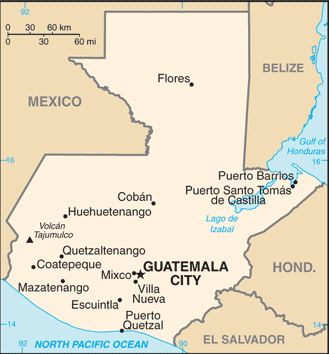 |
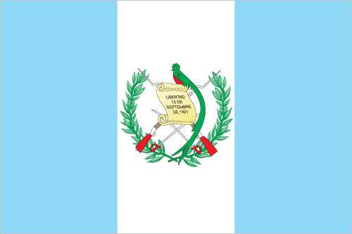
| The national flag of Guatemala | Borderline map of Guatemala |
| Flag description: three equal vertical bands of light blue (hoist side), white, and light blue, with the coat of arms centered in the white band; the coat of arms includes a green and red quetzal (the national bird) representing liberty and a scroll bearing the inscription LIBERTAD 15 DE SEPTIEMBRE DE 1821 (the original date of independence from Spain) all superimposed on a pair of crossed rifles signifying Guatemala’s willingness to defend itself and a pair of crossed swords representing honor and framed by a laurel wreath symbolizing victory; the blue bands represent the Pacific Ocean and Caribbean Sea; the white band denotes peace and purity. | Border length: total: 1,667 km. Border countries (total: 4): Belize 266 km, El Salvador 199 km, Honduras 244 km, Mexico 958 km. |
About Guatemala City
Set on a high, broad plateau and surrounded by volcanic peaks, Guatemala City is the largest city in the country, and the largest city in Central America, furthermore the only one with a contemporary, modern feel. That said, with a population of more than three million, the city is a sprawling, congested, confusing, and polluted urban mess. Guatemala City has a small but vibrant art and- nightlife scene, as well as some of the finest hotels and restaurants in the country. The city sits at an elevation of 1,469m (4,820 ft.) above sea level and enjoys moderate temperatures year-round. Home to the country’s principal international airport and bus connections to every corner of the country, Guatemala City serves as a de facto transportation hub for most, if not all, visitors.
Guatemala City was founded as the country’s third capital in 1776, following the destruction of two earlier attempts by natural disasters – earthquakes and mudslides. Christened with the unwieldy name of La Nueva Guatemala de La Asunción de la Valle de la Ermita by Spain’s King Charles III, its simple abbreviation, Guate most commonly know it. Long before the Spaniards moved their capital here, this was the site of the pre-Classic Maya city of Kaminaljuyú, whose ruins you can visit. Despite its well-deserved reputation as a sometimes violent and dangerous place, Guatemala City has a lot to offer for travelers. The principal commercial and tourist zones are full of elegant hotels and excellent restaurants, and the nightlife found in Zona Viva and Cuatro Grados Norte is the best in the country. The city also boasts theaters, art galleries, and several worthwhile museums.
Did you know about Guatemala?
- Guatemala declared independence at the same time as Mexico and, in 1823, became part of a union with the other Central American states.
- Guatemala, which means “land of trees, was the center of the ancient Mayan civilization.
- The largest and most populated of the seven Central American states, Guatemala is mountainous with a fertile plain along the Pacific coast. More than half its people are Amerindians-descendants of the original Maya inhabitants.
Today, Guatemala struggles to find its footing on the road to recovery. But that road, like so many in the country, is bumpy, winding, and steep. Still, for those intrepid travelers who do visit, you will find a land of exceptional beauty; heartfelt, humble, and diverse peoples; an overabundance of color and craftworks; and the almost perfectly preserved cities and streets of the ancient Maya and earliest Spanish settlers.
Facts of Guatemala (GT)
Name conventional long form: Republic of Guatemala, conventional short form: Guatemala, local long form: Republica de Guatemala, local short form: Guatemala, etymology: name derives from the Mayan word meaning “land of trees”
Codes: ISO; GT, Internet; .gt
Capital city: Guatemala City
Language(s): Spanish (official language) 60%, Amerindian languages 40%. Note: there are 23 official languagely recognized Amerindian languages, including Quiche, Cakchiquel, Kekchi, Mam, Garifuna, and Xinca
National holiday(s): Independence Day, 15 September (1821)
Motto: Libre, Crezca, Fecundo – El país de la eterna primavera (The Land of the Eternal Spring)
Currency: Guatemalan quetzal (GTQ), since 1925
GPS: 15 30 N, 90 15 W, Guatemala City; 14 37 N 90 31 W
Location: Central America, bordering the North Pacific Ocean, between El Salvador and Mexico, and bordering the Gulf of Honduras (Caribbean Sea) between Honduras and Belize
Geography note: no natural harbors on west coast
Land boundaries: Belize 266 km, El Salvador 199 km, Honduras 244 km, Mexico 958 km, total: 1,667 km
Maritime boundaries: N/A
Coastline: 400 km
Area: total: 108,889 sq km; land: 107,159 sq km, water: 1,730 sq km (total 42 042,26 mi2), slightly smaller than Pennsylvania.
Roadways: total: 17,332 km, paved: 7,483 km, unpaved: 9,849 km (includes 4,795 km of rural roads) (2015)
Waterways: 990 km (260 km navigable year round; additional 730 km navigable during high-water season) (2012)
Local time (capital): UTC-6, 1 hour behind Washington DC during Standard Time
Note to the local time: N/A
Population in Guatemala: 17 245 346
Population in Guatemala City: 2 655 900 (including the metropolitan areas)
Urbanization: urban population: 51.6% of total population (2015)
Major urban areas population: GUATEMALA CITY (capital) 2.918 million (2015)
Population growth rate: 1.79% (2016 estimate)
Birth rate: 24.5 births / 1,000 population (2016 estimate)
Death rate: 4.7 deaths / 1,000 population (2016 estimate)
Age structure: 0-14 years: 35.02% (male 2,711,683 / female 2,608,295) 15-24 years: 21.8% (male 1,663,484 / female 1,647,749) 25-54 years: 33.53% (male 2,425,931 / female 2,666,790) 55-64 years: 5.23% (male 377,642 / female 416,939) 65 years and over: 4.42% (male 311,165 / female 360,280) (2016 estimate)
Median age: total: 21.7 years; male: 21 years, female: 22.4 years (2016 estimate)
Ethnic groups: Mestizo (mixed Amerindian-Spanish – in local Spanish called Ladino) and European 59.4%, K’iche 9.1%, Kaqchikel 8.4%, Mam 7.9%, Q’eqchi 6.3%, other Mayan 8.6%, indigenous non-Mayan 0.2%, other 0.1% (2001 census)
Religions: Roman Catholic, Protestant, indigenous Mayan beliefs
Government type: Unitary presidential republic
Legal system: civil law system; judicial review of legislative acts
National anthem: Himno Nacional de Guatemala
Known national hazards: numerous volcanoes in mountains, with occasional violent earthquakes; Caribbean coast extremely susceptible to hurricanes and other tropical stormsvolcanism: significant volcanic activity in the Sierra Madre range; Santa Maria (elev. 3,772 m) has been deemed a Decade Volcano by the International Association of Volcanology and Chemistry of the Earth’s Interior, worthy of study due to its explosive history and proximity to human populations; Pacaya (elev. 2,552 m), which erupted in May 2010 causing an ashfall on Guatemala City and prompting evacuations, is one of the country’s most active volcanoes with frequent eruptions since 1965; other historically active volcanoes include Acatenango, Almolonga, Atitlan, Fuego, and Tacana
Major infectious diseases: The degree of risk(s): high food or waterborne diseases: bacterial diarrhea, hepatitis A, and typhoid fever vectorborne disease: dengue fever and malaria. Note: active local transmission of Zika virus by Aedes species mosquitoes has been identified in this country (as of August 2016); it poses an important risk (a large number of cases possible) among US citizens if bitten by an infective mosquito; other less common ways to get Zika are through sex, via blood transfusion, or during pregnancy, in which the pregnant woman passes Zika virus to her fetus (2016)
Land use: agricultural land: 41.2%; arable land 14.2%; permanent crops 8.8%; permanent pasture 18.2%; forest: 33.6%; other: 25.2% (2011 estimate)
Agricultural products: sugarcane, corn, bananas, coffee, beans, cardamom; cattle, sheep, pigs, chickens
Industries: sugar, textiles and clothing, furniture, chemicals, petroleum, metals, rubber, tourism
Export commodities: sugar, coffee, petroleum, apparel, bananas, fruits and vegetables, cardamom, manufacturing products, precious stones and metals, electricity
Main export partners: US 34.9%, El Salvador 8.4%, Honduras 7.3%, Nicaragua 5%, Canada 4.6%, Mexico 4.3%, Costa Rica 4.1% (2015)
Import commodities: fuels, machinery and transport equipment, construction materials, grain, fertilizers, electricity, mineral products, chemical products, plastic materials and products
Main import partners: US 38.3%, China 13.4%, Mexico 11.8%, El Salvador 4.9% (2015)
Navigate the countries in Central America and the Caribbean faster and easier while driving, use the interactive Google maps for your driving directions. The continuously updated database contains over 220 countries and territories digitally mapped, hundreds of millions of businesses and places around the world positioned on the map.
Get fresh GPS navigation, traffic, and transit information – no matter what part of Guatemala, Guatemala City, any other city and country in America, or the world you’re in.
Do you like this Guatemala information page? Please don’t forget to share it with others! Thank you.