Canada Google maps and Driving Directions
Get free driving directions, Google maps, traffic information for Canada, and Ottawa (GPS: 45 25 N 75 42 W), the capital city of the country located in (the) Northern North America, bordering the North Atlantic Ocean on the east, North Pacific Ocean on the west, and the Arctic Ocean on the north, north of the conterminous US.
Find any address in Ottawa on the Google map of Canada (CA) with ease or calculate your up to date itinerary to and from Canada or its neighboring counties like United States.
Sightseeing and exploring in America starts here, thanks to Google because its Earth Engine combines a multi-petabyte catalog of updated satellite imagery and geospatial datasets with planetary-scale analysis capabilities. Wonder the world, use the satellite map function of the Google maps to explore or see differences on the Earth’s surface, inland, or the surrounding areas of Canada.
Google Maps Canada
Canada extends from the Arctic to its US border along the 49th parallel. Unified under British rule from 1763, its development and expansion attracted large-scale immigration.
Canada is mostly plains with mountains in west, lowlands in southeast.
The map above fully covers Canada with its road routes from cities to towns, road intersections in any region, provinces, prefectures, also with free driving directions in Ottawa or to the neighboring towns and countries. To look at the detailed map about a particular quarter in Ottawa, please click on the area and zoom to the place you are interested in the Google maps of Canada (CA).
Be creative, use the extras of this Google map; This is a detailed, clear, zoomable, large road map of Canada with its administrative divisions; 10 provinces and 3 territories*; Alberta, British Columbia, Manitoba, New Brunswick, Newfoundland and Labrador, Northwest Territories*, Nova Scotia, Nunavut*, Ontario, Prince Edward Island, Quebec, Saskatchewan, Yukon*.
The interactive map above is also may be used as the satellite map of Canada, or as a reverse search map for finding an address from its GPS coordinates.
Covering most of the northern part of the North American continent and with an area larger than that of the United States, Canada has an extremely varied topography. In the east, the mountainous maritime provinces have an irregular coastline on the Gulf of St. Lawrence and the Atlantic. The St. Lawrence plain, covering most of southern Quebec and Ontario, and the interior continental plain, covering southern Manitoba and Saskatchewan and most of Alberta, are the principal cultivable areas. They are separated by a forested plateau rising from Lakes Superior and Huron. Westward toward the Pacific, most of British Columbia, the Yukon, and part of western Alberta are covered by parallel mountain ranges, including the Rockies. The Pacific border of the coast range is ragged with fjords and channels. The highest point in Canada is Mount Logan (19,850 ft 6,050 m), which is in the Yukon. The two principal river systems are the Mackenzie and the St. Lawrence. The St. Lawrence, with its tributaries, is navigable for over 1,900 mi (3,058 km). Canada shares borders with one neighboring country. This is the United States, with a shared border length of 8,893 km.
Canada (area: 9 984 670 sq km / 3 855 101,06 sq mi), where the official language is English, French, lying in America and using the currency; Canadian dollar (CAD), since 1858, set their clock to UTC-5. That means they are same time as Washington DC during Standard Time in Ottawa, the capital. Note to the time difference: Daylight saving time: +1hr begins second Sunday in March; ends first Sunday in November. Note: Canada has six time zones.
The climate in Canada; Ranges from polar and subpolar in the north, to continental in the south. Winters in the interior are colder and longer than on the coast, with temperatures well below freezing and deep snow; summers are hotter. Pacific coast has the mildest winters.
Geography in a nutshell; The worlds second-largest country, stretching north to Cape Colombia on Ellesmere Island, south to Lake Erie, and across five time zones from the Pacific seaboard to Newfoundland. Arctic tundra and islands in the far north give way southward to forests, interspersed with lakes and rivers, and then the vast Canadian Shield, which covers over half the area of Canada. Rocky Mountains in west, beyond which are the Coast Mountains, islands, and fjords. Fertile lowlands in the east.
Click here for more detailed information about Canada.
Driving directions Canada
The Google maps and Google Satellite maps of Canada above showing the country, located next to United States. For your further reference, the latitude and longitude coordinates of Canada are 60 00 N, 95 00 W , while the capital, Ottawa found at 45 25 N 75 42 W.
When you are traveling around Canada, Ottawa, or its other cities, use this routing tool, providing up to date route planning service free of charge.
Look no further; get accurate driving directions in Canada, North America, by filling the route planner form below.
Since Google acquired and introduced its digitalized maps in 2004, you’re probably familiar with its base functions, like finding an address or driving directions to locations. Still, Google maps also accommodate bicyclists, pedestrians, and also public transportation with special directions and customizable routes.
About Canada and the capital, Ottawa
 |
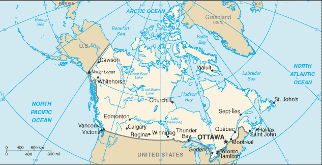 |
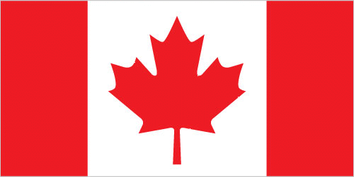
| The national flag of Canada | Borderline map of Canada |
| Flag description: two vertical bands of red (hoist and fly side, half width) with white square between them; an 11-pointed red maple leaf is centered in the white square; the maple leaf has long been a Canadian symbol. | Border length: total: 8,893 km. Border countries (total: 1): US 8,893 km (includes 2,477 km with Alaska). Note: Canada is the world’s largest country that borders only one country. |
Did you know about Canada?
- Canada became a nation in 1867 when fourcolonies united. Later, six other provinces and twoterritories joined the Confederation.
- The Magnetic North Pole, where the dipping needle of a compass stands still, migrates across northern Canada.
- A country rich in natural resources and beautiful scenery, Canada is the worlds second largest country but also one of the emptiest, with a population of just 32 million who mainly live in cities close to its southern border.
Facts of Canada (CA)
Name conventional long form: none, conventional short form: Canada, etymology: the country name derives from the St. Lawrence Iroquoian word “kanata” meaning village or settlement
Codes: ISO; CA, Internet; .ca
Capital city: Ottawa
Language(s): English (official language) 58.7%, French (official language) 22%, Punjabi 1.4%, Italian 1.3%, Spanish 1.3%, German 1.3%, Cantonese 1.2%, Tagalog 1.2%, Arabic 1.1%, other 10.5% (2011 estimate)
National holiday(s): Canada Day, 1 July (1867)
Motto: A mari usque ad mare (From Sea to Sea)
Currency: Canadian dollar (CAD), since 1858
GPS: 60 00 N, 95 00 W, Ottawa; 45 25 N 75 42 W
Location: Northern North America, bordering the North Atlantic Ocean on the east, North Pacific Ocean on the west, and the Arctic Ocean on the north, north of the conterminous US
Geography note: second-largest country in world (after Russia) and largest in the Americas; strategic location between Russia and US via north polar route; approximately 90% of the population is concentrated within 160 km (100 mi) of the US border; Canada has more fresh water than any other country and almost 9% of Canadian territory is water; Canada has at least 2 million and possibly over 3 million lakes – that is more than all other countries combined
Land boundaries: US 8,893 km (includes 2,477 km with Alaska). Note: Canada is the world’s largest country that borders only one country, total: 8,893 km
Maritime boundaries: N/A
Coastline: 202,080 km. Note: the Canadian Arctic Archipelago – consisting of 36,563 islands, several of them some of the world’s largest – contributes to Canada easily having the longest coastline in the world
Area: total: 9,984,670 sq km; land: 9,093,507 sq km, water: 891,163 sq km (total 3 855 101,06 mi2), slightly larger than the US.
Roadways: total: 1,042,300 km, paved: 415,600 km (includes 17,000 km of expressways), unpaved: 626,700 km (2011)
Waterways: 636 km (Saint Lawrence Seaway of 3,769 km, including the Saint Lawrence River of 3,058 km, shared with United States) (2011)
Local time (capital): UTC-5, same time as Washington DC during Standard Time
Note to the local time: Daylight saving time: +1hr begins second Sunday in March; ends first Sunday in November. Note: Canada has six time zones
Population in Canada: 36 953 765
Population in Ottawa: 1 142 700 (including the metropolitan areas)
Urbanization: urban population: 81.8% of total population (2015)
Major urban areas population: Toronto 5.993 million; Montreal 3.981 million; Vancouver 2.485 million; Calgary 1.337 million; OTTAWA (capital) 1.326 million; Edmonton 1.272 million (2015)
Population growth rate: 0.74% (2016 estimate)
Birth rate: 10.3 births / 1,000 population (2016 estimate)
Death rate: 8.5 deaths / 1,000 population (2016 estimate)
Age structure: 0-14 years: 15.44% (male 2,799,758 / female 2,661,645) 15-24 years: 12.12% (male 2,204,127 / female 2,080,587) 25-54 years: 40.32% (male 7,231,200 / female 7,028,692) 55-64 years: 13.94% (male 2,443,452 / female 2,484,788) 65 years and over: 18.18% (male 2,863,114 / female 3,565,542) (2016 estimate)
Median age: total: 42 years; male: 40.8 years, female: 43.3 years (2016 estimate)
Ethnic groups: Canadian 32.2%, English 19.8%, French 15.5%, Scottish 14.4%, Irish 13.8%, German 9.8%, Italian 4.5%, Chinese 4.5%, North American Indian 4.2%, other 50.9%note: percentages add up to more than 100% because respondents were able to identify more than one ethnic origin (2011 estimate)
Religions: Catholic 39% (includes Roman Catholic 38.8%, other Catholic .2%), Protestant 20.3% (includes United Church 6.1%, Anglican 5%, Baptist 1.9%, Lutheran 1.5%, Pentecostal 1.5%, Presbyterian 1.4%, other Protestant 2.9%), Orthodox 1.6%, other Christian 6.3%, Muslim 3.2%, Hindu 1.5%, Sikh 1.4%, Buddhist 1.1%, Jewish 1%, other 0.6%, none 23.9% (2011 estimate)
Government type: Federal parliamentary constitutional monarchy
Legal system: common law system except in Quebec, where civil law based on the French civil code prevails
National anthem: O Canada
Known national hazards: continuous permafrost in north is a serious obstacle to development; cyclonic storms form east of the Rocky Mountains, a result of the mixing of air masses from the Arctic, Pacific, and North American interior, and produce most of the country’s rain and snow east of the mountainsvolcanism: the vast majority of volcanoes in Western Canada’s Coast Mountains remain dormant
Major infectious diseases: N/A
Land use: agricultural land: 6.8%; arable land 4.7%; permanent crops 0.5%; permanent pasture 1.6%; forest: 34.1%; other: 59.1% (2011 estimate)
Agricultural products: wheat, barley, oilseed, tobacco, fruits, vegetables; dairy products; fish; forest products
Industries: transportation equipment, chemicals, processed and unprocessed minerals, food products, wood and paper products, fish products, petroleum, natural gas
Export commodities: motor vehicles and parts, industrial machinery, aircraft, telecommunications equipment; chemicals, plastics, fertilizers; wood pulp, timber, crude petroleum, natural gas, electricity, aluminum
Main export partners: US 76.7% (2015)
Import commodities: machinery and equipment, motor vehicles and parts, crude oil, chemicals, electricity, durable consumer goods
Main import partners: US 53.1%, China 12.2%, Mexico 5.8% (2015)
Navigate the countries in North America faster and easier while driving, use the interactive Google maps for your driving directions. The continuously updated database contains over 220 countries and territories digitally mapped, hundreds of millions of businesses and places around the world positioned on the map.
Get fresh GPS navigation, traffic, and transit information – no matter what part of Canada, Ottawa, any other city and country in America, or the world you’re in.
Do you like this Canada information page? Please don’t forget to share it with others! Thank you.