Honduras Google maps and Driving Directions
Get free driving directions, Google maps, traffic information for Honduras, and Tegucigalpa (GPS: 14 06 N 87 13 W), the capital city of the country located in (the) Central America, bordering the Caribbean Sea, between Guatemala and Nicaragua and bordering the Gulf of Fonseca (North Pacific Ocean), between El Salvador and Nicaragua.
Find any address in Tegucigalpa on the Google map of Honduras (HN) with ease or calculate your up to date itinerary to and from Honduras or its neighboring counties like El Salvador, Guatemala, Nicaragua.
Sightseeing and exploring in America starts here, thanks to Google because its Earth Engine combines a multi-petabyte catalog of updated satellite imagery and geospatial datasets with planetary-scale analysis capabilities. Wonder the world, use the satellite map function of the Google maps to explore or see differences on the Earth’s surface, inland, or the surrounding areas of Honduras.
Google Maps Honduras
Straddling the Central American isthmus, Honduras returned to democratic rule in 1984, after a period of military government. Hurricane Mitch devastated the country in 1998.
Honduras is mostly mountains in interior, narrow coastal plains.
The map above fully covers Honduras with its road routes from cities to towns, road intersections in any region, provinces, prefectures, also with free driving directions in Tegucigalpa or to the neighboring towns and countries. To look at the detailed map about a particular quarter in Tegucigalpa, please click on the area and zoom to the place you are interested in the Google maps of Honduras (HN).
Be creative, use the extras of this Google map; This is a detailed, clear, zoomable, large road map of Honduras with its administrative divisions; 18 departments (departamentos, singular – departamento); Atlantida, Choluteca, Colon, Comayagua, Copan, Cortes, El Paraiso, Francisco Morazan, Gracias a Dios, Intibuca, Islas de la Bahia, La Paz, Lempira, Ocotepeque, Olancho, Santa Barbara, Valle, Yoro.
The interactive map above is also may be used as the satellite map of Honduras, or as a reverse search map for finding an address from its GPS coordinates.
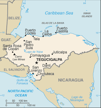
Honduras, in the north-central part of Central America, has a Caribbean as well as a Pacific coastline. Guatemala is to the west, El Salvador to the south, and Nicaragua to the east. The second-largest country in Central America, Honduras is slightly larger than Tennessee. Generally mountainous, the country is marked by fertile plateaus, river valleys, and narrow coastal plains.
Honduras (area: 112 492 sq km / 43 433,39 sq mi), where the official language is Spanish, lying in America and using the currency; Honduran lempira (HNL), since 1931, set their clock to UTC-6. That means they are 1 hour behind Washington DC during Standard Time in Tegucigalpa, the capital. Note to the time difference: N/A.
The climate in Honduras; Tropical coastal lowlands are hot and humid, with MayOctober rains. Interior is cooler and drier.
Geography in a nutshell; Narrow plains along both coasts, with a mountainous interior, cut by river valleys. Tropical forests, swamps, and lagoons in the east.
Click here for more detailed information about Honduras.
Driving directions Honduras
The Google maps and Google Satellite maps of Honduras above showing the country, located next to El Salvador, Guatemala, Nicaragua. For your further reference, the latitude and longitude coordinates of Honduras are 15 00 N, 86 30 W , while the capital, Tegucigalpa found at 14 06 N 87 13 W.
When you are traveling around Honduras, Tegucigalpa, or its other cities, use this routing tool, providing up to date route planning service free of charge.
Look no further; get accurate driving directions in Honduras, Central America and the Caribbean, by filling the route planner form below.
Since Google acquired and introduced its digitalized maps in 2004, you’re probably familiar with its base functions, like finding an address or driving directions to locations. Still, Google maps also accommodate bicyclists, pedestrians, and also public transportation with special directions and customizable routes.
About Honduras and the capital, Tegucigalpa
 |
 |
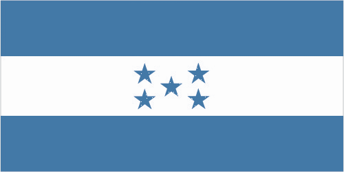
| The national flag of Honduras | Borderline map of Honduras |
| Flag description: three equal horizontal bands of blue (top), white, and blue, with five blue, five-pointed stars arranged in an X pattern centered in the white band; the stars represent the members of the former Federal Republic of Central America: Costa Rica, El Salvador, Guatemala, Honduras, and Nicaragua; the blue bands symbolize the Pacific Ocean and the Caribbean Sea; the white band represents the land between the two bodies of water and the peace and prosperity of its people. Note: similar to the flag of El Salvador, which features a round emblem encircled by the words REPUBLICA DE EL SALVADOR EN LA AMERICA CENTRAL centered in the white band; also similar to the flag of Nicaragua, which features a triangle encircled by the words REPUBLICA DE NICARAGUA on top and AMERICA CENTRAL on the bottom, centered in the white band. | Border length: total: 1,575 km. Border countries (total: 3): Guatemala 244 km, El Salvador 391 km, Nicaragua 940 km. |
About Tegucigalpa
Many travelers would instead not try to pronounce the name of the capital of Honduras, let alone visit it. (It’s pronounced “Te-goo-si-gal-pa.”) Whatever horror stories you have heard about Central American equities, don’t take them too seriously. While it isn’t a favorite tourist destination like Copán, La Ceiba, or the Bay Islands, “Tegus,” as Hondurans call it, is a reasonably pleasant place if you can get past the smog, shantytowns, and traffic. While it believed that the name was a Nahuatl word meaning “silver mountain,” that is likely not the case, that story probably made up to lure miners and settlers to the city in the mid-1500s. The meaning of the name is more clearly defined as “place of colored stones.” The city sits snugly in a valley at about 1,000m (3,280 ft.), sheltering it from the sweltering heat that plagues San Pedro Sula and La Ceiba. There are several excellent museums and churches within the colonial center, a great clump of cloud forest nearby, and the largest cathedral in the country, a revered pilgrimage site, is only minutes from the center.
The city founded on September 29, 1578, but it wasn’t until 1880 that the capital was moved here from Comayagua by President Marco Aurelio Soto. In 1938, the city of Comayagüela was incorporated into Tegucigalpa and nearly doubled the size, which today stands at over one million inhabitants. The city is no longer the economic center of the country (that is San Pedro), but, as the capital of Honduras, it’s still an essential area for commerce and politics.
Did you know about Honduras?
- Honduras was one of the Spanish colonies which formed the United Provinces of Central Americain 1823. It became independent in 1838.
- The Honduran currency is named after a Lenca Indian chief who was the main leader of resistance to the Spanish conquest in the 16th century.
- Mountainous Honduras has a long coastline on the Caribbean Sea and a short, sheltered outlet to the Pacific. Almost all of its 7.2 million people are Mestizos- mixed Spanish-Amerindian.
Much of it may still be taken up by banana cultivation, but few other countries in the world today can lay claim to such apparent natural beauty. About the size of Tennessee, Honduras is home to 20 national parks, a couple of biosphere reserves, and nearly 100 other protected ecological areas. The cultural diversity here is also notable. The country has almost eight million people, mostly mestizos (mixed descendants of the Spanish and Amerindians), as well as another 10% made up of eight main indigenous groups: the Lencas, the Chortís, the Tolupan, the Garífunas, the Miskitos, the Pech, the Tawahkas, and the Bay Islanders.
Adventure is woven into the fabric of this country over the past 400 years. Christopher Columbus set foot on the Bay Islands and the North Shore on his fourth and final voyage to the Americas in 1502, but that may be the most boring tale. Consider that the country’s history involves pirates raiding gold from Spanish ships and hiding the booty in caves on the Bay Islands, archaeologists searching for Maya ruins and crystal skulls, and a North American named William Walker launching a raid on the country with his own small army. Throw in conquistadors, indigenous warriors, multinational fruit corporations, whale sharks, and indigenous land rights, and you have one of the most exciting environments on the planet.
Until recently, Honduras’s tourist infrastructure limited, but things are slowly coming together, even with the political troubles that 2009 brought. Visitors can expect more variety, better hotels, and a more excellent range of wild and beautiful tours and attractions than before. With newly expanded ports, cruise landings on the Bay Islands have exploded. Luxury eco-lodges near La Ceiba can now compete with anywhere else in Central America, and beach resorts set to turn Tela Bay into the next Cancun. The Maya ruins of Copán are luring more and more visitors. Even La Mosquitia, traditionally one of the least accessible places in the Americas, is turning to community-based tours and excelling at them.
Facts of Honduras (HN)
Name conventional long form: Republic of Honduras, conventional short form: Honduras, local long form: Republica de Honduras, local short form: Honduras, etymology: the name means “depths” in Spanish and refers to the deep anchorage in the northern Bay of Trujillo
Codes: ISO; HN, Internet; .hn
Capital city: Tegucigalpa
Language(s): Spanish (official language), Amerindian dialects
National holiday(s): Independence Day, 15 September (1821)
Motto: Libre, soberana e independiente (Free, Sovereign and Independent)
Currency: Honduran lempira (HNL), since 1931
GPS: 15 00 N, 86 30 W, Tegucigalpa; 14 06 N 87 13 W
Location: Central America, bordering the Caribbean Sea, between Guatemala and Nicaragua and bordering the Gulf of Fonseca (North Pacific Ocean), between El Salvador and Nicaragua
Geography note: has only a short Pacific coast but a long Caribbean shoreline, including the virtually uninhabited eastern Mosquito Coast
Land boundaries: Guatemala 244 km, El Salvador 391 km, Nicaragua 940 km, total: 1,575 km
Maritime boundaries: N/A
Coastline: 823 km (Caribbean Sea 669 km, Gulf of Fonseca 163 km)
Area: total: 112,090 sq km; land: 111,890 sq km, water: 200 sq km (total 43 433,39 mi2), slightly larger than Tennessee.
Roadways: total: 14,742 km, paved: 3,367 km, unpaved: 11,375 km (1,543 km summer only), note: an additional 8,951 km of non-official roads used by the coffee industry (2012)
Waterways: 465 km (most navigable only by small craft) (2012)
Local time (capital): UTC-6, 1 hour behind Washington DC during Standard Time
Note to the local time: N/A
Population in Honduras: 9 417 167
Population in Tegucigalpa: 1 436 000 (including the metropolitan areas)
Urbanization: urban population: 54.7% of total population (2015)
Major urban areas population: TEGUCIGALPA (capital) 1.123 million; San Pedro Sula 852,000 (2015)
Population growth rate: 1.64% (2016 estimate)
Birth rate: 22.8 births / 1,000 population (2016 estimate)
Death rate: 5.2 deaths / 1,000 population (2016 estimate)
Age structure: 0-14 years: 33.55% (male 1,524,195 / female 1,459,679) 15-24 years: 21.09% (male 956,315 / female 918,925) 25-54 years: 36.19% (male 1,627,072 / female 1,591,025) 55-64 years: 4.99% (male 207,821 / female 235,776) 65 years and over: 4.19% (male 161,734 / female 210,717) (2016 estimate)
Median age: total: 22.6 years; male: 22.3 years, female: 23 years (2016 estimate)
Ethnic groups: mestizo (mixed Amerindian and European) 90%, Amerindian 7%, black 2%, white 1%
Religions: Roman Catholic 97%, Protestant 3%
Government type: Presidential republic
Legal system: civil law system
National anthem: Himno nacional de Honduras
Known national hazards: frequent, but generally mild, earthquakes; extremely susceptible to damaging hurricanes and floods along the Caribbean coast
Major infectious diseases: The degree of risk(s): high food or waterborne diseases: bacterial diarrhea, hepatitis A, and typhoid fever vectorborne diseases: dengue fever and malaria. Note: active local transmission of Zika virus by Aedes species mosquitoes has been identified in this country (as of August 2016); it poses an important risk (a large number of cases possible) among US citizens if bitten by an infective mosquito; other less common ways to get Zika are through sex, via blood transfusion, or during pregnancy, in which the pregnant woman passes Zika virus to her fetus (2016)
Land use: agricultural land: 28.8%; arable land 9.1%; permanent crops 4%; permanent pasture 15.7%; forest: 45.3%; other: 25.9% (2011 estimate)
Agricultural products: bananas, coffee, citrus, corn, African palm; beef; timber; shrimp, tilapia, lobster, sugar, oriental vegetables
Industries: sugar, coffee, woven and knit apparel, wood products, cigars
Export commodities: coffee, apparel, coffee, shrimp, automobile wire harnesses, cigars, bananas, gold, palm oil, fruit, lobster, lumber
Main export partners: US 36%, Germany 8.7%, El Salvador 8.5%, Guatemala 6%, Nicaragua 5.6%, Netherlands 4.1% (2015)
Import commodities: communications equipment, machinery and transport, industrial raw materials, chemical products, fuels, foodstuffs
Main import partners: US 35.2%, China 13.6%, Guatemala 9.2%, Mexico 6.6%, El Salvador 5.1% (2015)
Navigate the countries in Central America and the Caribbean faster and easier while driving, use the interactive Google maps for your driving directions. The continuously updated database contains over 220 countries and territories digitally mapped, hundreds of millions of businesses and places around the world positioned on the map.
Get fresh GPS navigation, traffic, and transit information – no matter what part of Honduras, Tegucigalpa, any other city and country in America, or the world you’re in.
Do you like this Honduras information page? Please don’t forget to share it with others! Thank you.