Haiti Google maps and Driving Directions
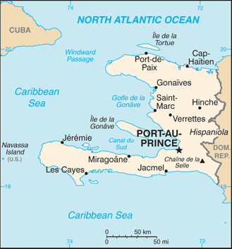
Get free driving directions, Google maps, traffic information for Haiti, and Port-au-Prince (GPS: 18 32 N 72 20 W), the capital city of the country located in (the) Caribbean, western one-third of the island of Hispaniola, between the Caribbean Sea and the North Atlantic Ocean, west of the Dominican Republic.
Find any address in Port-au-Prince on the Google map of Haiti (HT) with ease or calculate your up to date itinerary to and from Haiti or its neighboring counties like Dominican Republic.
Sightseeing and exploring in America starts here, thanks to Google because its Earth Engine combines a multi-petabyte catalog of updated satellite imagery and geospatial datasets with planetary-scale analysis capabilities. Wonder the world, use the satellite map function of the Google maps to explore or see differences on the Earth’s surface, inland, or the surrounding areas of Haiti.
Google Maps Haiti
Formerly a French colony, Haiti shares the Caribbean island of Hispaniola with the Dominican Republic. At independence in 1804, it became the worlds first black republic.
Haiti is mostly rough and mountainous.
The map above fully covers Haiti with its road routes from cities to towns, road intersections in any region, provinces, prefectures, also with free driving directions in Port-au-Prince or to the neighboring towns and countries. To look at the detailed map about a particular quarter in Port-au-Prince, please click on the area and zoom to the place you are interested in the Google maps of Haiti (HT).
Be creative, use the extras of this Google map; This is a detailed, clear, zoomable, large road map of Haiti with its administrative divisions; 10 departments (departements, singular – departement); Artibonite, Centre, Grand’Anse, Nippes, Nord, Nord-Est, Nord-Ouest, Ouest, Sud, Sud-Est.
The interactive map above is also may be used as the satellite map of Haiti, or as a reverse search map for finding an address from its GPS coordinates.
Haiti, in the West Indies, occupies the western third of the island of Hispaniola, which it shares with the Dominican Republic. About the size of Maryland, Haiti is two-thirds mountainous, with the rest of the country marked by great valleys, extensive plateaus, and small plains.
Haiti (area: 27 750 sq km / 10 714,33 sq mi), where the official language is French, Haitian Creole, lying in America and using the currency; Haitian gourde (HTG), since 1813, set their clock to UTC-5. That means they are same time as Washington DC during Standard Time in Port-au-Prince, the capital. Note to the time difference: Daylight saving time: none in 2016.
The climate in Haiti; Tropical, with rain throughout the year. Humid in coastal areas, much cooler in the mountains.
Geography in a nutshell; Predominantly mountainous, with forests and fertile plains.
Click here for more detailed information about Haiti.
Driving directions Haiti
The Google maps and Google Satellite maps of Haiti above showing the country, located next to Dominican Republic. For your further reference, the latitude and longitude coordinates of Haiti are 19 00 N, 72 25 W , while the capital, Port-au-Prince found at 18 32 N 72 20 W.
When you are traveling around Haiti, Port-au-Prince, or its other cities, use this routing tool, providing up to date route planning service free of charge.
Look no further; get accurate driving directions in Haiti, Central America and the Caribbean, by filling the route planner form below.
Since Google acquired and introduced its digitalized maps in 2004, you’re probably familiar with its base functions, like finding an address or driving directions to locations. Still, Google maps also accommodate bicyclists, pedestrians, and also public transportation with special directions and customizable routes.
About Haiti and the capital, Port-au-Prince
 |
 |
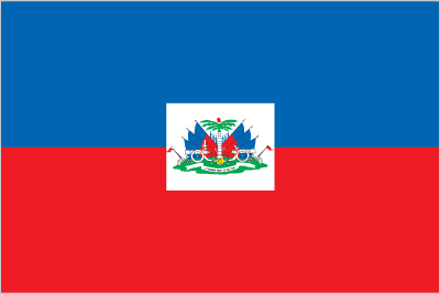
| The national flag of Haiti | Borderline map of Haiti |
| Flag description: two equal horizontal bands of blue (top) and red with a centered white rectangle bearing the coat of arms, which contains a palm tree flanked by flags and two cannons above a scroll bearing the motto L’UNION FAIT LA FORCE (Union Makes Strength); the colors are taken from the French Tricolor and represent the union of blacks and mulattoes. | Border length: total: 376 km. Border countries (total: 1): Dominican Republic 376 km. |
Did you know about Haiti?
- Haiti became a French colony in 1697, but in 1803 a rebellion broke out. Independence granted on January 1, 1804.
- A slave rebellion headed by Toussaint Louverture in 1791 led to Haitis independence.
- The island of Hispaniola is shared by two nations-Haiti (the first independent nation in the Caribbean) in the west and the Dominican Republic in the east.
Facts of Haiti (HT)
Name conventional long form: Republic of Haiti, conventional short form: Haiti, local long form: Republique d’Haiti/Repiblik d Ayiti, local short form: Haiti/Ayiti, etymology: the native Taino name means “land of high mountains” and was originally applied to the entire island of Hispaniola
Codes: ISO; HT, Internet; .ht
Capital city: Port-au-Prince
Language(s): French (official language), Creole (official language)
National holiday(s): Independence Day, 1 January (1804)
Motto: Liberté, Égalité, Fraternité (Liberty, Equality, Fraternity)
Currency: Haitian gourde (HTG), since 1813
GPS: 19 00 N, 72 25 W, Port-au-Prince; 18 32 N 72 20 W
Location: Caribbean, western one-third of the island of Hispaniola, between the Caribbean Sea and the North Atlantic Ocean, west of the Dominican Republic
Geography note: shares island of Hispaniola with Dominican Republic (western one-third is Haiti, eastern two-thirds is the Dominican Republic)
Land boundaries: Dominican Republic 376 km, total: 376 km
Maritime boundaries: N/A
Coastline: 1,771 km
Area: total: 27,750 sq km; land: 27,560 sq km, water: 190 sq km (total 10 714,33 mi2), slightly smaller than Maryland.
Roadways: total: 4,266 km, paved: 768 km, unpaved: 3,498 km (2009)
Waterways: N/A
Local time (capital): UTC-5, same time as Washington DC during Standard Time
Note to the local time: Daylight saving time: none in 2016
Population in Haiti: 11 112 945
Population in Port-au-Prince: 1 764 000 (including the metropolitan areas)
Urbanization: urban population: 58.6% of total population (2015)
Major urban areas population: PORT-AU-PRINCE (capital) 2.44 million (2015)
Population growth rate: 1.71% (2016 estimate)
Birth rate: 23.3 births / 1,000 population (2016 estimate)
Death rate: 7.7 deaths / 1,000 population (2016 estimate)
Age structure: 0-14 years: 33.39% (male 1,744,599 / female 1,756,155) 15-24 years: 21.35% (male 1,120,532 / female 1,118,278) 25-54 years: 36.24% (male 1,885,478 / female 1,914,078) 55-64 years: 4.94% (male 246,453 / female 271,455) 65 years and over: 4.09% (male 189,098 / female 239,674) (2016 estimate)
Median age: total: 22.6 years; male: 22.4 years, female: 22.8 years (2016 estimate)
Ethnic groups: black 95%, mulatto and white 5%
Religions: Roman Catholic (official) 54.7%, Protestant 28.5% (Baptist 15.4%, Pentecostal 7.9%, Adventist 3%, Methodist 1.5%, other 0.7%), voodoo (official) 2.1%, other 4.6%, none 10.2%note: many Haitians practice elements of voodoo in addition to another religion, most often Roman Catholicism; voodoo was recognized as an official religion in 2003
Government type: Unitary semi-presidential republic
Legal system: civil law system strongly influenced by Napoleonic Code
National anthem: La Dessalinienne (The Dessalines Song)
Known national hazards: lies in the middle of the hurricane belt and subject to severe storms from June to October; occasional flooding and earthquakes; periodic droughts
Major infectious diseases: The degree of risk(s): very high food or waterborne diseases: bacterial and protozoal diarrhea, hepatitis A and E, and typhoid fever vectorborne diseases: dengue fever and malaria. Note: active local transmission of Zika virus by Aedes species mosquitoes has been identified in this country (as of August 2016); it poses an important risk (a large number of cases possible) among US citizens if bitten by an infective mosquito; other less common ways to get Zika are through sex, via blood transfusion, or during pregnancy, in which the pregnant woman passes Zika virus to her fetus (2016)
Land use: agricultural land: 66.4%; arable land 38.5%; permanent crops 10.2%; permanent pasture 17.7%; forest: 3.6%; other: 30% (2011 estimate)
Agricultural products: coffee, mangoes, cocoa, sugarcane, rice, corn, sorghum; wood, vetiver
Industries: textiles, sugar refining, flour milling, cement, light assembly using imported parts
Export commodities: apparel, manufactures, oils, cocoa, mangoes, coffee
Main export partners: US 85.3% (2015)
Import commodities: food, manufactured goods, machinery and transport equipment, fuels, raw materials
Main import partners: Dominican Republic 35.3%, US 24.5%, Netherlands Antilles 9.4%, China 9.4% (2015)
Navigate the countries in Central America and the Caribbean faster and easier while driving, use the interactive Google maps for your driving directions. The continuously updated database contains over 220 countries and territories digitally mapped, hundreds of millions of businesses and places around the world positioned on the map.
Get fresh GPS navigation, traffic, and transit information – no matter what part of Haiti, Port-au-Prince, any other city and country in America, or the world you’re in.
Do you like this Haiti information page? Please don’t forget to share it with others! Thank you.