Bangladesh Google maps and Driving Directions
Get free driving directions, Google maps, traffic information for Bangladesh, and Dhaka (GPS: 23 43 N 90 24 E), the capital city of the country located in (the) Southern Asia, bordering the Bay of Bengal, between Myanmar and India.
Find any address in Dhaka on the Google map of Bangladesh (BG) with ease or calculate your up to date itinerary to and from Bangladesh or its neighboring counties like India, Myanmar.
Sightseeing and exploring in Asia starts here, thanks to Google because its Earth Engine combines a multi-petabyte catalog of updated satellite imagery and geospatial datasets with planetary-scale analysis capabilities. Wonder the world, use the satellite map function of the Google maps to explore or see differences on the Earth’s surface, inland, or the surrounding areas of Bangladesh.
Google Maps Bangladesh
Bangladesh lies at the north end of the Bay of Bengal and frequently suffers devastating flood, cyclones, and famine. It seceded from Pakistan in 1971.
Bangladesh is mostly flat alluvial plain; hilly in southeast.
The map above fully covers Bangladesh with its road routes from cities to towns, road intersections in any region, provinces, prefectures, also with free driving directions in Dhaka or to the neighboring towns and countries. To look at the detailed map about a particular quarter in Dhaka, please click on the area and zoom to the place you are interested in the Google maps of Bangladesh (BG).
Be creative, use the extras of this Google map; This is a detailed, clear, zoomable, large road map of Bangladesh with its administrative divisions; 8 divisions; Barisal, Chittagong, Dhaka, Khulna, Mymensingh, Rajshahi, Rangpur, Sylhet.
The interactive map above is also may be used as the satellite map of Bangladesh, or as a reverse search map for finding an address from its GPS coordinates.
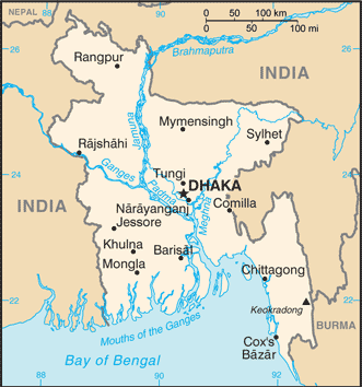
Bangladesh, on the northern coast of the Bay of Bengal, is surrounded by India, with a small common border with Myanmar in the southeast. The country is low-lying riverine land traversed by the many branches and tributaries of the Ganges and Brahmaputra rivers. Tropical monsoons and frequent floods and cyclones inflict heavy damage in the delta region.
Bangladesh (area: 143 998 sq km / 55 597,92 sq mi), where the official language is Bengali, lying in Asia and using the currency; Bangladeshi taka (BDT), since 1972, set their clock to UTC+6. That means they are 11 hours ahead of Washington DC during Standard Time in Dhaka, the capital. Note to the time difference: N/A.
The climate in Bangladesh; Hot and humid. During the monsoon, water levels can rise 20 ft (6 m) above sea level.
Geography in a nutshell; Mostly flat alluvial plains and deltas of the Brahmaputra and Ganges rivers. Southeast coasts are fringed with mangrove forests.
Click here for more detailed information about Bangladesh.
Driving directions Bangladesh
The Google maps and Google Satellite maps of Bangladesh above showing the country, located next to India, Myanmar. For your further reference, the latitude and longitude coordinates of Bangladesh are 24 00 N, 90 00 E , while the capital, Dhaka found at 23 43 N 90 24 E.
When you are traveling around Bangladesh, Dhaka, or its other cities, use this routing tool, providing up to date route planning service free of charge.
Look no further; get accurate driving directions in Bangladesh, Asia, by filling the route planner form below.
Since Google acquired and introduced its digitalized maps in 2004, you’re probably familiar with its base functions, like finding an address or driving directions to locations. Still, Google maps also accommodate bicyclists, pedestrians, and also public transportation with special directions and customizable routes.
About Bangladesh and the capital, Dhaka
 |
 |
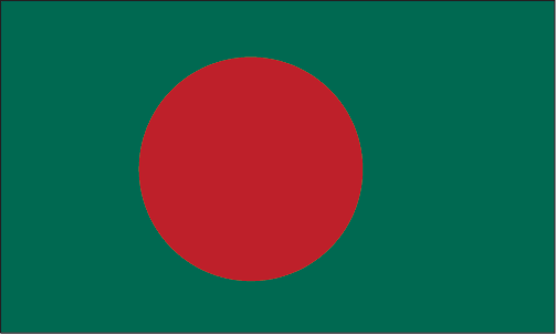
| The national flag of Bangladesh | Borderline map of Bangladesh |
| Flag description: green field with a large red disk shifted slightly to the hoist side of center; the red disk represents the rising sun and the sacrifice to achieve independence; the green field symbolizes the lush vegetation of Bangladesh. | Border length: total: 4,413 km. Border countries (total: 2): Myanmar 271 km, India 4,142 km. |
Did you know about Bangladesh?
- Bangladesh was formerly the eastern province of Pakistan. After a civil war with Pakistan, it became a separate country in 1971.
- Torrential monsoon rains flood two-thirds of the country every year.
- Low-lying Bangladesh is ideal for growing jute-a tough, fibrous plant that is used to make rope, sacking, and carpet backing.
Facts of Bangladesh (BG)
Name conventional long form: People’s Republic of Bangladesh, conventional short form: Bangladesh, local long form: Gana Prajatantri Bangladesh, local short form: Bangladesh, former: East Bengal, East Pakistan, etymology: the name – a compound of the Bengali words “Bangla” (Bengal) and “desh” (country) – means “Country of Bengal”
Codes: ISO; BG, Internet; .bd
Capital city: Dhaka
Language(s): Bangla 98.8% (official language, also known as Bengali), other 1.2% (2011 estimate)
National holiday(s): Independence Day, 26 March (1971); Victory Day, 16 December (1971)emorializes the military victory over Pakistan and the official creation of the state of Bangladesh
Motto: N/A
Currency: Bangladeshi taka (BDT), since 1972
GPS: 24 00 N, 90 00 E, Dhaka; 23 43 N 90 24 E
Location: Southern Asia, bordering the Bay of Bengal, between Myanmar and India
Geography note: most of the country is situated on deltas of large rivers flowing from the Himalayas: the Ganges unites with the Jamuna (main channel of the Brahmaputra) and later joins the Meghna to eventually empty into the Bay of Bengal
Land boundaries: Myanmar 271 km, India 4,142 km, total: 4,413 km
Maritime boundaries: Bay of Bengal
Coastline: 580 km
Area: total: 148,460 sq km; land: 130,170 sq km, water: 18,290 sq km (total 55 597,92 mi2), slightly smaller than Iowa.
Roadways: total: 21,269 km, paved: 2,021 km, unpaved: 19,248 km (2010)
Waterways: 8,370 km (includes up to 3,060 km of main cargo routes; network reduced to 5,200 km in the dry season) (2011)
Local time (capital): UTC+6, 11 hours ahead of Washington DC during Standard Time
Note to the local time: N/A
Population in Bangladesh: 166 368 149
Population in Dhaka: 12 560 000 (including the metropolitan areas)
Urbanization: urban population: 34.3% of total population (2015)
Major urban areas population: DHAKA (capital) 17.598 million; Chittagong 4.539 million; Khulna 1.022 million; Rajshahi 844,000 (2015)
Population growth rate: 1.05% (2016 estimate)
Birth rate: 19 births / 1,000 population (2016 estimate)
Death rate: 5.3 deaths / 1,000 population (2016 estimate)
Age structure: 0-14 years: 28.27% (male 22,456,564 / female 21,695,491) 15-24 years: 19.53% (male 15,261,363 / female 15,247,635) 25-54 years: 39.39% (male 29,565,250 / female 31,951,537) 55-64 years: 6.77% (male 5,232,828 / female 5,342,822) 65 years and over: 6.04% (male 4,493,557 / female 4,939,835) (2016 estimate)
Median age: total: 26.3 years; male: 25.6 years, female: 26.9 years (2016 estimate)
Ethnic groups: Bengali at least 98%, ethnic groups 1.1%note: Bangladesh’s government recognizes 27 ethnic groups under the 2010 Cultural Institution for Small Anthropological Groups Act; other sources estimate there are about 75 ethnic groups; critics of the 2011 census claim that it underestimates the size of Bangladesh’s ethnic population (2011 estimate)
Religions: Muslim 89.1%, Hindu 10%, other 0.9% (includes Buddhist, Christian) (2013 estimate)
Government type: Unitary parliamentary republic
Legal system: mixed legal system of mostly English common law and Islamic law
National anthem: Amar Shonar Bangla (My Golden Bengal)
Known national hazards: droughts; cyclones; much of the country routinely inundated during the summer monsoon season
Major infectious diseases: The degree of risk(s): high food or waterborne diseases: bacterial and protozoal diarrhea, hepatitis A and E, and typhoid fever vectorborne diseases: dengue fever and malaria are high risks in some locationswater contact disease: leptospirosisanimal contact disease: rabies (2016)
Land use: agricultural land: 70.1%; arable land 59%; permanent crops 6.5%; permanent pasture 4.6%; forest: 11.1%; other: 18.8% (2011 estimate)
Agricultural products: rice, jute, tea, wheat, sugarcane, potatoes, tobacco, pulses, oilseeds, spices, fruit; beef, milk, poultry
Industries: jute, cotton, garments, paper, leather, fertilizer, iron and steel, cement, petroleum products, tobacco, pharmaceuticals, ceramics, tea, salt, sugar, edible oils, soap and detergent, fabricated metal products, electricity, natural gas
Export commodities: garments, knitwear, agricultural products, frozen food (fish and seafood), jute and jute goods, leather
Main export partners: US 13.9%, Germany 12.9%, UK 8.9%, France 5%, Spain 4.7% (2015)
Import commodities: cotton, machinery and equipment, chemicals, iron and steel, foodstuffs
Main import partners: China 22.4%, India 14.1%, Singapore 5.2% (2015)
Navigate the countries in Asia faster and easier while driving, use the interactive Google maps for your driving directions. The continuously updated database contains over 220 countries and territories digitally mapped, hundreds of millions of businesses and places around the world positioned on the map.
Get fresh GPS navigation, traffic, and transit information – no matter what part of Bangladesh, Dhaka, any other city and country in Asia, or the world you’re in.
Do you like this Bangladesh information page? Please don’t forget to share it with others! Thank you.