Fiji Google maps and Driving Directions
Get free driving directions, Google maps, traffic information for Fiji, and Suva (GPS: 18 08 S 178 25 E), the capital city of the country located in (the) Oceania, island group in the South Pacific Ocean, about two-thirds of the way from Hawaii to New Zealand.
Find any address in Suva on the Google map of Fiji (FJ) with ease or calculate your up to date itinerary to and from Fiji or its neighboring counties like N/A.
Sightseeing and exploring in Oceania starts here, thanks to Google because its Earth Engine combines a multi-petabyte catalog of updated satellite imagery and geospatial datasets with planetary-scale analysis capabilities. Wonder the world, use the satellite map function of the Google maps to explore or see differences on the Earth’s surface, inland, or the surrounding areas of Fiji.
Google Maps Fiji
A volcanic archipelago in the South Pacific, with two large islands and 880 islets. Tensions between native Fijians and the Indian minority have sparked a succession of coups.
Fiji is mostly mountains of volcanic origin.
The map above fully covers Fiji with its road routes from cities to towns, road intersections in any region, provinces, prefectures, also with free driving directions in Suva or to the neighboring towns and countries. To look at the detailed map about a particular quarter in Suva, please click on the area and zoom to the place you are interested in the Google maps of Fiji (FJ).
Be creative, use the extras of this Google map; This is a detailed, clear, zoomable, large road map of Fiji with its administrative divisions; 14 provinces and 1 dependency*; Ba, Bua, Cakaudrove, Kadavu, Lau, Lomaiviti, Macuata, Nadroga and Navosa, Naitasiri, Namosi, Ra, Rewa, Rotuma*, Serua, Tailevu.
The interactive map above is also may be used as the satellite map of Fiji, or as a reverse search map for finding an address from its GPS coordinates.
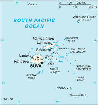
Fiji consists of 332 islands in the southwest Pacific Ocean about 1,960 mi (3,152 km) from Sydney, Australia. About 110 of these islands are inhabited. The two largest are Viti Levu (4,109 sq mi 10,642 sq km) and Vanua Levu (2,242 sq mi 5,807 sq km).
Fiji (area: 18 272 sq km / 7 054,86 sq mi), where the official language is English, Fijian, Hindi, lying in Oceania and using the currency; Fijian dollar (FJD), since 1969, set their clock to UTC+12. That means they are 17 hours ahead of Washington DC during Standard Time in Suva, the capital. Note to the time difference: Daylight saving time: +1hr begins fourth Sunday in October; ends third Sunday in January.
The climate in Fiji; Tropical. High temperatures all year round. Cyclones are a hazard.
Geography in a nutshell; Main islands are mountainous, fringed by coral reefs. Remainder are limestone and coral formations.
Click here for more detailed information about Fiji.
Driving directions Fiji
The Google maps and Google Satellite maps of Fiji above showing the country, located next to N/A. For your further reference, the latitude and longitude coordinates of Fiji are 18 00 S, 175 00 E , while the capital, Suva found at 18 08 S 178 25 E.
When you are traveling around Fiji, Suva, or its other cities, use this routing tool, providing up to date route planning service free of charge.
Look no further; get accurate driving directions in Fiji, Oceania, by filling the route planner form below.
Since Google acquired and introduced its digitalized maps in 2004, you’re probably familiar with its base functions, like finding an address or driving directions to locations. Still, Google maps also accommodate bicyclists, pedestrians, and also public transportation with special directions and customizable routes.
About Fiji and the capital, Suva
 |
 |
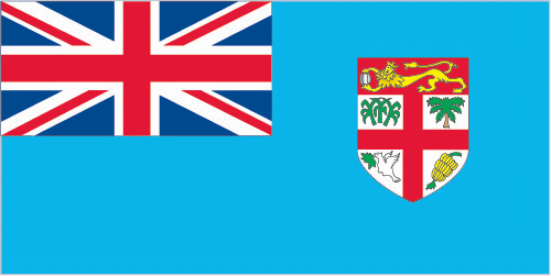
| The national flag of Fiji | Borderline map of Fiji |
| Flag description: light blue with the flag of the UK in the upper hoist-side quadrant and the Fijian shield centered on the outer half of the flag; the blue symbolizes the Pacific ocean and the Union Jack reflects the links with Great Britain; the shield – taken from Fiji’s coat of arms – depicts a yellow lion above a white field quartered by the cross of Saint George; the four quarters depict stalks of sugarcane, a palm tree, bananas, and a white dove. | Border length: 0 km. |
Did you know about Fiji?
- Fiji became part of the British Empire in 1874, and an independent nation with dominion status within the Common wealth in 1970.
- Both Fijians and Indians practice fire-walking; Indians walk on hot embers, Fijians on heated stones.
- The main crop grown on Fiji is sugar cane, which is exported along with copra and gold.
Facts of Fiji (FJ)
Name conventional long form: Republic of Fiji, conventional short form: Fiji, local long form: Republic of Fiji/Matanitu ko Viti, local short form: Fiji/Viti, etymology: the Fijians called their home Viti, but the neighboring Tongans called it Fisi, and in the Anglicized spelling of the Tongan pronunciation – promulgated by explorer Captain James COOK – the designation became Fiji
Codes: ISO; FJ, Internet; .fj
Capital city: Suva
Language(s): English (official language), Fijian (official language), Hindustani
National holiday(s): Constitution Day, 7 September; Fiji (independence) Day, 10 October (1970)
Motto: Rerevaka na Kalou ka Doka na Tui (Fear God and honour the Queen)
Currency: Fijian dollar (FJD), since 1969
GPS: 18 00 S, 175 00 E, Suva; 18 08 S 178 25 E
Location: Oceania, island group in the South Pacific Ocean, about two-thirds of the way from Hawaii to New Zealand
Geography note: includes 332 islands; approximately 110 are inhabited
Land boundaries: N/A, 0 km
Maritime boundaries: Pacific Ocean
Coastline: 1,129 km
Area: total: 18,274 sq km; land: 18,274 sq km, water: 0 sq km (total 7 054,86 mi2), slightly smaller than New Jersey.
Roadways: total: 3,440 km, paved: 1,686 km, unpaved: 1,754 km (2011)
Waterways: 203 km (122 km are navigable by motorized craft and 200-metric-ton barges) (2012)
Local time (capital): UTC+12, 17 hours ahead of Washington DC during Standard Time
Note to the local time: Daylight saving time: +1hr begins fourth Sunday in October; ends third Sunday in January
Population in Fiji: 912 241
Population in Suva: 177 300 (including the metropolitan areas)
Urbanization: urban population: 53.7% of total population (2015)
Major urban areas population: SUVA (capital) 176,000 (2014)
Population growth rate: 0.63% (2016 estimate)
Birth rate: 19 births / 1,000 population (2016 estimate)
Death rate: 6.1 deaths / 1,000 population (2016 estimate)
Age structure: 0-14 years: 27.88% (male 130,414 / female 124,774) 15-24 years: 16.42% (male 76,709 / female 73,565) 25-54 years: 41.11% (male 192,605 / female 183,681) 55-64 years: 8.29% (male 38,427 / female 37,412) 65 years and over: 6.31% (male 26,534 / female 31,182) (2016 estimate)
Median age: total: 28.6 years; male: 28.4 years, female: 28.8 years (2016 estimate)
Ethnic groups: iTaukei 56.8% (predominantly Melanesian with a Polynesian admixture), Indian 37.5%, Rotuman 1.2%, other 4.5% (European, part European, other Pacific Islanders, Chinese). Note: a 2010 law replaces ‘Fijian’ with ‘iTuakei’ when referring to the original and native settlers of Fiji (2007 estimate)
Religions: Protestant 45% (Methodist 34.6%, Assembly of God 5.7%, Seventh Day Adventist 3.9%, and Anglican 0.8%), Hindu 27.9%, other Christian 10.4%, Roman Catholic 9.1%, Muslim 6.3%, Sikh 0.3%, other 0.3%, none 0.8% (2007 estimate)
Government type: Unitary parliamentary constitutional republic
Legal system: common law system based on the English model
National anthem: God Bless Fiji
Known national hazards: cyclonic storms can occur from November to January
Major infectious diseases: note: active local transmission of Zika virus by Aedes species mosquitoes has been identified in this country (as of August 2016); it poses an important risk (a large number of cases possible) among US citizens if bitten by an infective mosquito; other less common ways to get Zika are through sex, via blood transfusion, or during pregnancy, in which the pregnant woman passes Zika virus to her fetus (2016)
Land use: agricultural land: 23.3%; arable land 9%; permanent crops 4.7%; permanent pasture 9.6%; forest: 55.7%; other: 21% (2011 estimate)
Agricultural products: sugarcane, coconuts, cassava (manioc, tapioca), rice, sweet potatoes, bananas; cattle, pigs, horses, goats; fish
Industries: tourism, sugar, clothing, copra, gold, silver, lumber, small cottage industries
Export commodities: sugar, garments, gold, timber, fish, molasses, coconut oil, mineral water
Main export partners: US 13.4%, Australia 10.2%, Samoa 6.7%, Tonga 5.9% (2015)
Import commodities: manufactured goods, machinery and transport equipment, petroleum products, food, chemicals
Main import partners: China 16.2%, South Korea 15.7%, NZ 14%, Australia 13.4%, Singapore 8.7%, France 7% (2015)
Navigate the countries in Oceania faster and easier while driving, use the interactive Google maps for your driving directions. The continuously updated database contains over 220 countries and territories digitally mapped, hundreds of millions of businesses and places around the world positioned on the map.
Get fresh GPS navigation, traffic, and transit information – no matter what part of Fiji, Suva, any other city and country in Oceania, or the world you’re in.
Do you like this Fiji information page? Please don’t forget to share it with others! Thank you.