Myanmar (Burma) Google maps and Driving Directions
Get free driving directions, Google maps, traffic information for Myanmar (Burma), and Rangoon (GPS: 16 48 N 96 09 E), the capital city of the country located in (the) Southeastern Asia, bordering the Andaman Sea and the Bay of Bengal, between Bangladesh and Thailand.
Find any address in Rangoon on the Google map of Myanmar (Burma) (MM) with ease or calculate your up to date itinerary to and from Myanmar (Burma) or its neighboring counties like Bangladesh, China, India, Laos, Thailand.
Sightseeing and exploring in Asia starts here, thanks to Google because its Earth Engine combines a multi-petabyte catalog of updated satellite imagery and geospatial datasets with planetary-scale analysis capabilities. Wonder the world, use the satellite map function of the Google maps to explore or see differences on the Earth’s surface, inland, or the surrounding areas of Myanmar (Burma).
Google Maps Myanmar (Burma)
Forming the eastern shores of the Bay of Bengal and the Andaman Sea in southeast Asia, Myanmar suffers from isolation, political repression, and ethnic conflict.
Myanmar (Burma) is central lowlands ringed by steep, rugged highlands.
The map above fully covers Myanmar (Burma) with its road routes from cities to towns, road intersections in any region, provinces, prefectures, also with free driving directions in Rangoon or to the neighboring towns and countries. To look at the detailed map about a particular quarter in Rangoon, please click on the area and zoom to the place you are interested in the Google maps of Myanmar (Burma) (MM).
Be creative, use the extras of this Google map; This is a detailed, clear, zoomable, large road map of Myanmar (Burma) with its administrative divisions; 7 regions (taing-myar, singular – taing), 7 states (pyi ne-myar, singular – pyi ne), 1 union territoryregions: Ayeyawady (Irrawaddy), Bago, Magway, Mandalay, Sagaing, Taninthayi, Yangon (Rangoon)states: Chin, Kachin, Kayah, Kayin, Mon, Rakhine (Arakan), Shanunion territory: Nay Pyi Taw.
The interactive map above is also may be used as the satellite map of Myanmar (Burma), or as a reverse search map for finding an address from its GPS coordinates.
Slightly smaller than Texas, Myanmar occupies the Thailand/Cambodia portion of the Indochinese peninsula. India lies to the northwest and China to the northeast. Bangladesh, Laos, and Thailand are also neighbors. The Bay of Bengal touches the southwest coast. The fertile delta of the Irrawaddy River in the south contains a network of interconnecting canals and nine principal river mouths.
Myanmar (area: 676 578 sq km / 261 228,12 sq mi), where the official language is Burmese, lying in Asia and using the currency; Burmese kyat (MMK), since 1952, set their clock to UTC+6.5. That means they are 11.5 hours ahead of Washington DC during Standard Time in Rangoon, the capital. Note to the time difference: N/A.
The climate in Myanmar (Burma); Tropical. Hot summers, with high humidity, and warm winters.
Geography in a nutshell; The fertile Irrawaddy basin lies at the center. Mountains to the west, Shan plateau to the east. Tropical rainforest covers much of the land.
Click here for more detailed information about Myanmar (Burma).
Driving directions Myanmar (Burma)
The Google maps and Google Satellite maps of Myanmar (Burma) above showing the country, located next to Bangladesh, China, India, Laos, Thailand. For your further reference, the latitude and longitude coordinates of Myanmar (Burma) are 22 00 N, 98 00 E , while the capital, Rangoon found at 16 48 N 96 09 E.
When you are traveling around Myanmar (Burma), Rangoon, or its other cities, use this routing tool, providing up to date route planning service free of charge.
Look no further; get accurate driving directions in Myanmar (Burma), Southeast Asia, by filling the route planner form below.
Since Google acquired and introduced its digitalized maps in 2004, you’re probably familiar with its base functions, like finding an address or driving directions to locations. Still, Google maps also accommodate bicyclists, pedestrians, and also public transportation with special directions and customizable routes.
About Myanmar (Burma) and the capital, Rangoon
 |
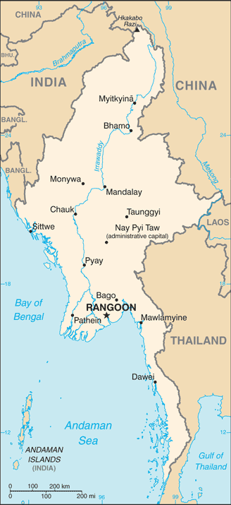 |
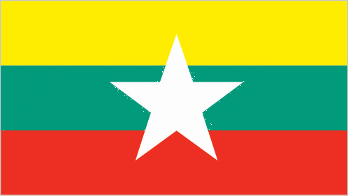
| The national flag of Myanmar (Burma) | Borderline map of Myanmar (Burma) |
| Flag description: design consists of three equal horizontal stripes of yellow (top), green, and red; centered on the green band is a large white five-pointed star that partially overlaps onto the adjacent colored stripes; the design revives the triband colors used by Burma from 1943-45, during the Japanese occupation. | Border length: total: 6,522 km. Border countries (total: 5): Bangladesh 271 km, China 2,129 km, India 1,468 km, Laos 238 km, Thailand 2,416 km. |
Did you know about Myanmar (Burma)?
- In 1886, Myanmar became a province of British India. It separated from India in 1937, and gained independence from British colonial control in 1948.
- Myanmar is one of the worlds biggest teak exporters, though reserves are diminishing rapidly.
- The deep-red rubies mined in Myanmar are considered to be the best in the world.
Facts of Myanmar (Burma) (MM)
Name conventional long form: Union of Burma, conventional short form: Burma, local long form: Pyidaungzu Thammada Myanma Naingngandaw (translated as the Republic of the Union of Myanmar), local short form: Myanma Naingngandaw, former: Socialist Republic of the Union of Burma, Union of Myanmar. Note: since 1989 the military authorities in Burma and the current parliamentary government have promoted the name Myanmar as a conventional name for their state; the US Government has not adopted the name, etymology: both “Burma” and “Myanmar” derive from the name of the majority Burmese Bamar ethnic group
Codes: ISO; MM, Internet; .mm
Capital city: Rangoon
Language(s): Burmese (official language). Note: minority ethnic groups have their own languages
National holiday(s): Independence Day, 4 January (1948); Union Day, 12 February (1947)
Motto: N/A
Currency: Burmese kyat (MMK), since 1952
GPS: 22 00 N, 98 00 E, Rangoon; 16 48 N 96 09 E
Location: Southeastern Asia, bordering the Andaman Sea and the Bay of Bengal, between Bangladesh and Thailand
Geography note: strategic location near major Indian Ocean shipping lanes; the north-south flowing Irrawaddy River is the country’s largest and most important commercial waterway
Land boundaries: Bangladesh 271 km, China 2,129 km, India 1,468 km, Laos 238 km, Thailand 2,416 km, total: 6,522 km
Maritime boundaries: Andaman Sea, Bay of Bengal
Coastline: 1,930 km
Area: total: 676,578 sq km; land: 653,508 sq km, water: 23,070 sq km (total 261 228,12 mi2), slightly smaller than Texas.
Roadways: total: 34,377 km (includes 358 km of expressways) (2010)
Waterways: 12,800 km (2011)
Local time (capital): UTC+6.5, 11.5 hours ahead of Washington DC during Standard Time
Note to the local time: N/A
Population in Myanmar (Burma): 53 855 735
Population in Rangoon: 4 344 100 (including the metropolitan areas)
Urbanization: urban population: 34.1% of total population (2015)
Major urban areas population: RANGOON (Yangon) (capital) 4.802 million; Mandalay 1.167 million; Nay Pyi Taw 1.03 million (2015)
Population growth rate: 1% (2016 estimate)
Birth rate: 18.2 births / 1,000 population (2016 estimate)
Death rate: 7.9 deaths / 1,000 population (2016 estimate)
Age structure: 0-14 years: 25.77% (male 7,476,436 / female 7,183,049) 15-24 years: 17.73% (male 5,109,120 / female 4,978,572) 25-54 years: 43.54% (male 12,326,900 / female 12,442,398) 55-64 years: 7.49% (male 2,003,593 / female 2,256,146) 65 years and over: 5.47% (male 1,353,723 / female 1,760,481) (2016 estimate)
Median age: total: 28.6 years; male: 28 years, female: 29.3 years (2016 estimate)
Ethnic groups: Myanmarn 68%, Shan 9%, Karen 7%, Rakhine 4%, Chinese 3%, Indian 2%, Mon 2%, other 5%
Religions: Buddhist 87.9%, Christian 6.2%, Muslim 4.3%, Animist 0.8%, Hindu 0.5%, other 0.2%, none 0.1%note: religion estimate is based on the 2014 national census, including an estimate for the non-enumerated population of Rakhine State, which is assumed to mainly affiliate with the Islamic faith (2014 estimate)
Government type: Unitary parliamentary constitutional republic
Legal system: mixed legal system of English common law (as introduced in codifications designed for colonial India) and customary law
National anthem: Kaba Ma Kyei (Till the End of the World)
Known national hazards: destructive earthquakes and cyclones; flooding and landslides common during rainy season (June to September); periodic droughts
Major infectious diseases: The The degree of risk(s): very high food or waterborne diseases: bacterial and protozoal diarrhea, hepatitis A, and typhoid fever vectorborne diseases: dengue fever, malaria, and Japanese encephalitiswater contact disease: leptospirosisanimal contact disease: rabies (2016)
Land use: agricultural land: 19.2%; arable land 16.5%; permanent crops 2.2%; permanent pasture 0.5%; forest: 48.2%; other: 32.6% (2011 estimate)
Agricultural products: rice, pulses, beans, sesame, groundnuts; sugarcane; fish and fish products; hardwood
Industries: agricultural processing; wood and wood products; copper, tin, tungsten, iron; cement, construction materials; pharmaceuticals; fertilizer; oil and natural gas; garments; jade and gems
Export commodities: natural gas; wood products; pulses and beans; fish; rice; clothing; minerals, including jade and gems
Main export partners: China 37.7%, Thailand 25.6%, India 7.7%, Japan 6.2% (2015)
Import commodities: fabric; petroleum products; fertilizer; plastics; machinery; transport equipment; cement, construction materials; food products edible oil
Main import partners: China 42.2%, Thailand 18.5%, Singapore 11%, Japan 4.8% (2015)
Navigate the countries in Southeast Asia faster and easier while driving, use the interactive Google maps for your driving directions. The continuously updated database contains over 220 countries and territories digitally mapped, hundreds of millions of businesses and places around the world positioned on the map.
Get fresh GPS navigation, traffic, and transit information – no matter what part of Myanmar (Burma), Rangoon, any other city and country in Asia, or the world you’re in.
Do you like this Myanmar (Burma) information page? Please don’t forget to share it with others! Thank you.